When you get a wilderness permit to go out on "May Lake trail", which trailhead should one use?
Trailhead #1: Snow Flat trailhead
I see one trailhead at the end of a 'rough road' about 1 or 2 miles from where it leaves Tioga road. The area is marked Snow Flat on the map. From here ML is 1.2 miles away.
Trailhead #2:
There is a trailhead very close to the junction of the rough road and Tioga road. The trail pretty much runs parallel to the road and meets the snow flat trailhead (#1). Seems to be the extension of Tenaya Lake/Tuolumne Meadows trail along snow creek. This is 2.4 miles long to Trailhead #1.
Trailhead #3:
There is a trailhead a little west of the west end of Tenaya Lake. 1.2 miles long and it meets Trailhead #1.
Where is the Tuolumne Meadows shuttle bus stop #11 - is it at Trailhead #3? (Shuttle bus stop #11 is named May Lake Trailhead and I assume that is exactly the location that the Wilderness Permit is valid for).

The Moon is Waxing Gibbous (79% of Full)
Re: where exactly is the May Lake trailhead?
All posts are those of the individual authors and the owner
of this site does not endorse them. Content should be considered opinion
and not fact until verified independently.
|
where exactly is the May Lake trailhead? June 14, 2011 09:01PM | Registered: 15 years ago Posts: 14 |
June 14, 2011 09:28PM | Registered: 15 years ago Posts: 2,321 |
Quote
rpf123
When you get a wilderness permit to go out on "May Lake trail", which trailhead should one use?
Trailhead #1: Snow Flat trailhead
I see one trailhead at the end of a 'rough road' about 1 or 2 miles from where it leaves Tioga road. The area is marked Snow Flat on the map. From here ML is 1.2 miles away.
Trailhead #2:
There is a trailhead very close to the junction of the rough road and Tioga road. The trail pretty much runs parallel to the road and meets the snow flat trailhead (#1). Seems to be the extension of Tenaya Lake/Tuolumne Meadows trail along snow creek. This is 2.4 miles long to Trailhead #1.
Trailhead #3:
There is a trailhead a little west of the west end of Tenaya Lake. 1.2 miles long and it meets Trailhead #1.
Where is the Tuolumne Meadows shuttle bus stop #11 - is it at Trailhead #3? (Shuttle bus stop #11 is named May Lake Trailhead and I assume that is exactly the location that the Wilderness Permit is valid for).
The trailhead is at the end of the "rough road" where there is car parking. How you get to that point is of no matter. If you walk up from 120 on the rough road to the parking area you will be entering from trailhead #17. If you hike in on one of the other methods you will still be entering at trailhead #17.
From the start of trailhead #17 you will still have to hike to a point that day that is far enough in to satisfy the distance from the trailhead before camping requirement.
There is a pdf file that has all the trailheads in the park with indications showing how far you have to hike prior to camping. I will send you a private message with my email.
Old Dude
June 14, 2011 09:46PM | Registered: 14 years ago Posts: 7,421 |
June 14, 2011 09:50PM | Registered: 15 years ago Posts: 2,321 |
June 14, 2011 09:51PM | Registered: 14 years ago Posts: 7,421 |
Why not just say go here:
Trailhead stuff is here if needed:
http://www.nps.gov/yose/planyourvisit/wildpermits.htm
1. Once you know where you want to begin your hike from, use the trailheads map [1 MB PDF] to determine the name of your trailhead.

Trailhead stuff is here if needed:
http://www.nps.gov/yose/planyourvisit/wildpermits.htm
1. Once you know where you want to begin your hike from, use the trailheads map [1 MB PDF] to determine the name of your trailhead.
June 15, 2011 12:21AM | Registered: 15 years ago Posts: 4,173 |

|
Re: where exactly is the May Lake trailhead? June 14, 2011 09:29PM | Registered: 15 years ago Posts: 14 |
June 14, 2011 09:37PM | Registered: 14 years ago Posts: 7,421 |
Lemme splain:
It's very simple.
Heading North to May Lake? - That is "May Lake" Permit
Heading South toward Snow Creek - That is "May Lake/Snow Creek" Permit
It doesn't matter if you start ON Tioga (which will be the case if May Lake road doesn't open yet).
Or if you start at the End of May Lake Road.
With either permit you can start at either place if you want. If you run into a ranger I guarantee
they will not give you any grief.
The shuttle bus will dump you on Tioga.
June 14, 2011 09:38PM | Registered: 15 years ago Posts: 2,321 |
Quote
rpf123
Shuttle bus stop #11 must be at Trailhead #3, becauase bus-stop #12 is Olmstead which is between Trailhead #3 and Trailhead #2. And wilderness permit should be good for that...
The shuttle bus stop numbers have no relation to the trailhead numbers. May Lake has two trailhead numbers, #16 which starts at 120 where the rough road intersects 120. This is #16 trailhead goes south along snow creek. Trailhead #17 which is at the north end of the rough road goes north toward May Lake.
Old Dude
June 14, 2011 09:48PM | Registered: 14 years ago Posts: 7,421 |
June 14, 2011 09:51PM | Admin Registered: 15 years ago Posts: 17,051 |
June 14, 2011 09:52PM | Registered: 14 years ago Posts: 7,421 |
June 14, 2011 09:52PM | Admin Registered: 15 years ago Posts: 17,051 |
June 14, 2011 10:00PM | Registered: 14 years ago Posts: 7,421 |
Sorry I got into this.
But maybe this will clear it up:
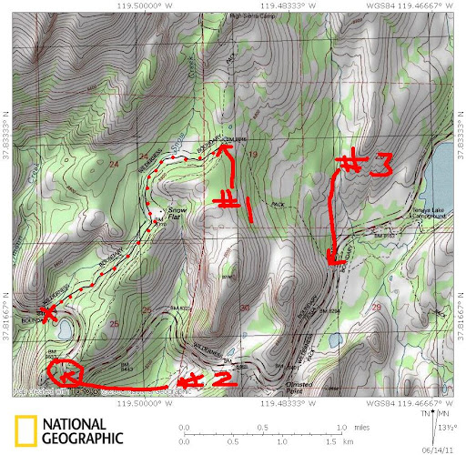
Dotted red line is May Lake Road.
#1 - End of May Lake Road (it's actually Old Tioga Rd. btw)
If road is open and you have "May Lake" permit that is where you want to start -
you can go south if you have May Lake/Snow Creek TH
#2 - Tioga / Snow Creek Trail junction
This is more than likely where the bus will dump you off.
Head north - May Lake TH
Head south - May Lake/Snow Creek TH
#3 - NOT a Trailhead - play frogger to get across
If want you can park at the X and walk the road too. There are bear boxes there.
Shoulda went to bed
But maybe this will clear it up:
Dotted red line is May Lake Road.
#1 - End of May Lake Road (it's actually Old Tioga Rd. btw)
If road is open and you have "May Lake" permit that is where you want to start -
you can go south if you have May Lake/Snow Creek TH
#2 - Tioga / Snow Creek Trail junction
This is more than likely where the bus will dump you off.
Head north - May Lake TH
Head south - May Lake/Snow Creek TH
#3 - NOT a Trailhead - play frogger to get across
If want you can park at the X and walk the road too. There are bear boxes there.
Shoulda went to bed
June 14, 2011 10:02PM | Registered: 14 years ago Posts: 7,421 |

June 15, 2011 03:31AM | Moderator Registered: 15 years ago Posts: 1,876 |
Quote
chick-on
Also btw... #3 from Tioga Road to May Lake Road... that is Old Tioga Also.
As Chick-on stated previously in this thread, the May Lake Road is actually part of the Old Tioga Road. Then it turned SE at the present day parking area and this "wide boulevard" trail follows the old roadbed.
Here is a link that provides information and a map of the various road incarnations:
http://www.yosemite.ca.us/library/tioga_road/title.html
June 19, 2011 07:12PM | Registered: 13 years ago Posts: 398 |
Last summer we got off the shuttle on the east side of Tenaya Lake, and hiked around the backside of the lake before heading up to May Lake HSC. We took the grey trail shown that starts between 18 and 19, and goes up to 17 on the map. We found it difficult to find that trailhead from where we were coming from though; especially trying to look for it while walking along the busy road.
July 27, 2011 07:20AM | Registered: 14 years ago Posts: 7,421 |
OK. I'll admit I'm wrong when I'm wrong.
#3 is "May Lake Trailhead" according to the Tuolumne Meadows Shuttle Bus stop.
I personally don't understand the TM Shuttle Bus. Why does it only go to Olmsted?
This last weekend I saw a couple of cars parked there too. Why you'd park there is
questionable. It would make a nice starting point for my Murphy Ridge route if
making a loop by May Lake and back out.
July 27, 2011 07:56AM | Registered: 12 years ago Posts: 159 |
That was probably a car with our group. We were starting in TM and ending at May Lake and wanted to leave a car rather than use the shuttle. When the dirt road was closed and the Sunrise parking was packed, we left our car there where the trail crosses Tioga.
We ended up going back out through TM and picking that car up on the way out. It seemed like a good idea at the time...
We ended up going back out through TM and picking that car up on the way out. It seemed like a good idea at the time...
July 27, 2011 08:26AM | Registered: 15 years ago Posts: 4,173 |
Quote
chick-on
OK. I'll admit I'm wrong when I'm wrong.
#3 is "May Lake Trailhead" according to the Tuolumne Meadows Shuttle Bus stop.
I personally don't understand the TM Shuttle Bus. Why does it only go to Olmsted?
In past years, the Tioga Road shuttle did start at either the May Lake TH parking lot, or at least at the May Lake Road/Tioga Road junction. Don't know when or why they shorten the shuttle route.
Sorry, only registered users may post in this forum.

