Welcome! Log In Create A New Profile Recent Posts
Nevada Falls

The Moon is Waxing Gibbous (54% of Full)


Advanced

Re: The Falls on Fireplace Creek (long)

All posts are those of the individual authors and the owner of this site does not endorse them. Content should be considered opinion and not fact until verified independently.

The Falls on Fireplace Creek (long)
June 17, 2011 04:32PM
This is part of my posts on abandoned roads and off-trail hikes near Yosemite Valley. It is a side trip from the Old Big Oak Flat Road hike. But that thread already has 77 posts, so I'll start a new one about the waterfall.

See Old Big Oak Flat Road Thread

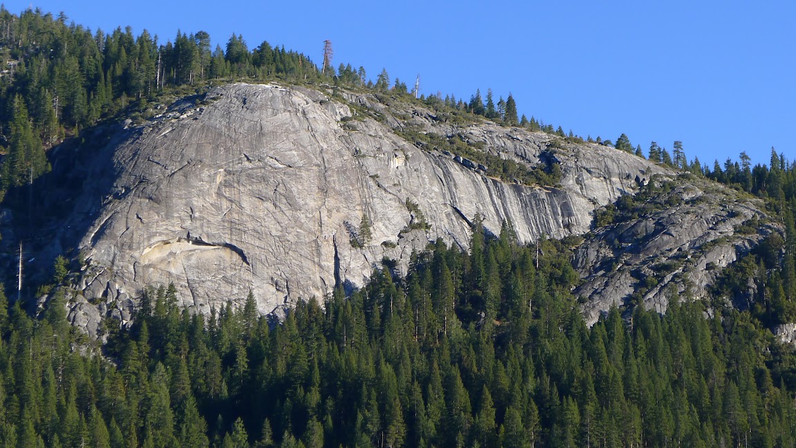
We drove into the Valley on Saturday, when the snow melt was filling all the waterfalls. From the Half Dome View turnout near the Foresta tunnels, or even better from across the valley at the famous Tunnel View, you can see a waterfall on Fireplace Creek. This creek flows down alongside the great gray cliffs known as Fireplace Bluff. It is a continuous cascade for a couple thousand feet, but they are in the woods and can't be seen unless you go there. An exception is the falls, which is about a hundred feet tall. The lower third of it is hidden in the trees.

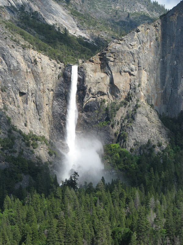
Here is a view from the Wawona tunnel entrance:


Anyway, it looked like a nice bushwhack, so I went up to take a look. The hike up along the old road is well described elsewhere. You only have to climb a few hundred feet from the valley floor to get the best view anywhere of Bridalveil Falls.


Beyond that, you follow the old road past the swtichback, past the pipe rail at Rainbow View, and on to Fireplace Creek. Shortly after the pipe rail, as I was going up, I met Mr. Bear coming down. It wasn't at a place where either of us could get off the road, with a steep bank on one side and a stonework drop on the other.


A bear usually has the right of way, but it was a very long way back to any place where I could safely get off the trail. So I waved my hat and began loudly singing "My Grandfather's Clock". After two verses, he got a disgusted look on his face (everyone is a critic) and turned around. Eventually he found a ravine and disappeared up the hill...

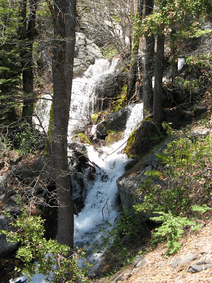
The old road starts at elevation 4000 feet. Fireplace Creek crossing is at 5350. The base of the falls is at 5800. The creek was a bit high for crossing, but I didn't intend to cross. I backed off to a good place to start up, and bushwhacked up the hill, keeping the cascade occasionally in sight. Here is the lower third of the falls. The rock face is convex, and there is no place on this side of the creek to see the upper two-thirds of it:


To the right of the falls is a long smooth granite cliff whose base slants up to the right. I was able to follow along to where I could get above it, and double back towards the top. At this point the creek is back to its usual cascade:


One-way distance was only four miles, but the off-trail part was steep dirt and pine needles. Elevation gain was 2200 feet. 400 of those were from climbing up above the falls. There were absolutely no tourists and no gum wrappers anywhere on this hike.
Re: The Falls on Fireplace Creek (long)
June 17, 2011 11:07PM
Here are some maps:
map link


Re: The Falls on Fireplace Creek (long)
June 18, 2011 10:04AM
Love the entries on the old roads. Wish I lived closer to Yosemite like I used to to take advantage of the great information.

So, Fireplace Creek looked too high to cross? I'm really beginning to reconsider my North Rim trip for next weekend. Just sounds like there are limited options (initially wanted to start at Tamarack, but held Snow Creek or Yosemite Falls out as possibilities too) and all creek crossings are fast, furious, and high.
Re: The Falls on Fireplace Creek (long)
June 18, 2011 06:04PM
Quote
KC2669
So, Fireplace Creek looked too high to cross? I'm really beginning to reconsider my North Rim trip for next weekend. Just sounds like there are limited options (initially wanted to start at Tamarack, but held Snow Creek or Yosemite Falls out as possibilities too) and all creek crossings are fast, furious, and high.

I didn't try. The flooded part of the road was shallow, but about 15 feet wide. It looked to be only boot-top deep, but there were undoubtedly deeper spots.

The snow is vanishing at an amazing rate. I would guess that in a week or so, all the creeks with small drainage areas, like Fireplace Creek, will be much smaller. On a trek from Snow Creek to Yosemite Creek trails, there is a good bridge at Yosemite Creek, and you don't have to cross Snow Creek at all. Your biggest problem might be Indian Creek. I would be willing to try it, but would bring water shoes and hiking poles in case I couldn't find a suitable log crossing....
avatar Re: The Falls on Fireplace Creek (long)
June 21, 2011 07:12AM
Very cool.
I've looked up from that road many times now... and said it would be fun to zig up the slides and shrub and cliffs to towards the top o Ribbon.
Looks do-able. wink

I presume you've been to the top o Royal Arch Cascade?
Was gonna go up Indian Canyon and then zig back down (yeah, a LONG way back down) to the top.
With the water starting to subside and the valley becoming a zoo... prob. not this year...


Chick-on is looking at you!
Re: The Falls on Fireplace Creek (long)
June 21, 2011 08:13AM
Quote
chick-on
Very cool.
I've looked up from that road many times now... and said it would be fun to zig up the slides and shrub and cliffs to towards the top o Ribbon.
Looks do-able. wink

I presume you've been to the top o Royal Arch Cascade?
Was gonna go up Indian Canyon and then zig back down (yeah, a LONG way back down) to the top.
With the water starting to subside and the valley becoming a zoo... prob. not this year...

Yes, from where I turned around it certainly looks OK to continue on to Ribbon Meadow. That was my original interest in this area, to find a short cut down from the end of El Cap Ridge to the Valley. However, I've concluded that while it may be shorter, it certainly won't be any easier or faster than the long way around.

Hiking up from the old road to where I turned around, it had all been forest. It's quite possible that things could get bushy farther up. Or not. Time to go take look? This part of the canyon gets very hot later in the summer.

Yes, I've been to the top of the Royal Arches Cascade, but in low water. Met a climber there who had just finished the climb, and who set off to go down the North Dome Gully in flip-flops. I was very impressed by that. I had come down from the North Dome Trail, and subsequently descended via Indian Canyon....
avatar Re: The Falls on Fireplace Creek (long)
June 21, 2011 08:57AM
Ok. So I also assume it's not too bad to get to the top of Washington from Royal Arch.
Spying it from all over... it looks very angled... but looking at things from far away
can be very deceiving. As you know it doesn't take much to make it...
Route was gonna be something like
Indian Canyon->Royal Arch->Wash Col->North Dome->Basket->Snow Creek.
Comment?

(sorry if I sorta digress from the subject of the thread)


Chick-on is looking at you!
Re: The Falls on Fireplace Creek (long)
June 21, 2011 12:41PM
Quote
chick-on
Ok. So I also assume it's not too bad to get to the top of Washington from Royal Arch.
Spying it from all over... it looks very angled... but looking at things from far away
can be very deceiving. As you know it doesn't take much to make it...
Route was gonna be something like
Indian Canyon->Royal Arch->Wash Col->North Dome->Basket->Snow Creek.
Comment?

(sorry if I sorta digress from the subject of the thread)

Yes. Whether you come down from the North Dome saddle or come in from the west, either way you walk across the same bit of slick rock to get to Washington Column. Easy stuff, as long as you don't dwell too much on how it rolls away and gets steeper below you. You won't have any trouble.

The end of the climb, which is just to the east of the falls, has a nice view. So does Washington Column, though there is some brush.
Re: The Falls on Fireplace Creek (long)
January 14, 2012 06:15PM
There was no snow, so I cancelled my ski trip and spent a few days with friends in the Valley last week. One bit of unfinished business was to scout the rest of the hike up past Fireplace Falls.


This map shows the uphill part of the trip. It leaves the Old Big Oak Flat Road just east of Fireplace Creek, and ends up at the El Capitan Trail. From there, we hiked down that trail to its junction with the Old Big Oak Flat Road at Gentry's Station, then followed the old road back to the start. No snow at all.

The gate down at the highway was open, so we drove up the old road to where it starts its climb to the west, and parked there.

Since the falls were pretty much dried up, I skipped the rock ribs just east of the falls, and followed a major game trail about fifty yards to the east, up through a break in the cliff band. This was steep dirt all the way. Then we hiked along the creek above the falls, and at the first convenient place where there wasn't a rock wall on the other side, we crossed over and went onto the zone between forest and slick rock. It was easy walking, not very steep.


But a short walk to the left shows what the bluff is like:


The views are good, but the low angle January sun made photography difficult. Here is a view back to the Tunnel View parking lot:


A bit higher and we get a view of the Big Meadow at Foresta. Also the tunnel #2 entrance on the road to Crane Flat, and the talus pile which marks the end of the Old Coulterville Road:


Finally, we reach a large open area near the top, with good views. To the west, across a deep gully, is the rib of rock that the El Capitan trail runs up:


That's the trail over there, but you can't really see it from here:


Now that I have checked it out, I probably won't do the loop in this direction again. The steep dirt on the lower half was covered with pine needles at this season, and was difficult going in some places. It would be much easier to go up the El Cap Trail, and come down beside the bluff...


Edited 1 time(s). Last edit at 07/16/2012 08:38AM by wherever.
avatar Re: The Falls on Fireplace Creek (long)
January 16, 2012 09:25AM
Very cool.

The view of the bluff from Old Inspiration:


Looking at those and topo map I would try this way:


(re-reading your post... looks like you may have already said that though)

Not sure what you mean by tunnel #2. That's the first tunnel heading east.

Thanks for posting


Chick-on is looking at you!
Re: The Falls on Fireplace Creek (long)
January 16, 2012 09:07PM
Quote
chick-on
Very cool.

The view of the bluff from Old Inspiration:


Looking at those and topo map I would try this way:


I didn't try the west bank route, because I really wanted to get up this time. It seemed impossible to tell whether that slanting ledge going up would be easy, or whether it would alternate between steep sooth rock and impenetrable bushes. The sad thing is that I stood right at the sharp left bend in your route and didn't go a bit farther to check out the route going down. I was thinking about what was ahead. Perhaps one more scouting trip is needed. Any excuse for one is welcome...


Quote
chick-on
Not sure what you mean by tunnel #2. That's the first tunnel heading east.

You are right. It's not #2. It's #3. The gov'ment numbers them from the valley. See
http://yosemitenews.info/forum/read.php?3,48261,48783#msg-48783
avatar Re: The Falls on Fireplace Creek (long)
January 30, 2012 07:39AM
I don't propose stuff I wouldn't do myself.

You will find that the route RIGHT NEXT to Fireplace Bluffs is worth the effort.
Very minimal shrub. Just hug the side of the sheer wall.

Gmap4 Map from Garmin Vista HCx

Gmap4 Map from Garmin eTrex 30

I'll get some photos together soon


Chick-on is looking at you!
avatar Re: The Falls on Fireplace Creek (long)
January 30, 2012 10:50AM
Quote
chick-on

Gmap4 Map from Garmin Vista HCx

Gmap4 Map from Garmin eTrex 30


It looks like the eTrex 30 produces a cleaner more accurate track than the Vista HCx (either that or you took a really nasty fall according to the Vista HCx (or was it Larry that was carrying the Vista HCx and he accidentally (ahem) took that nasty fall)).


Edited 1 time(s). Last edit at 01/30/2012 11:26AM by plawrence.
avatar Re: The Falls on Fireplace Creek (long)
January 30, 2012 05:26PM
Although the 30 looks cleaner.... amazingly (to me) alongside the bluff and
above it... the Vista has a much better track. Why? beats me... maybe it
was dog tired like me?
Here's the tracks on same map:


Chick-on is looking at you!
avatar Re: The Falls on Fireplace Creek (long)
January 30, 2012 05:31PM
Two of my favorite of next to the Bluff:


Chick-on is looking at you!
Re: The Falls on Fireplace Creek (long)
January 31, 2012 03:01PM
Fabulous. Thanks. I will certainly have to try that route. It's common in Yosemite for a path to exist along the base of a slick rock face, where the runoff has kept the brush at bay. This one looks like a winner.

I glad to hear that there was no problem with bad places going up along the base of the bluff. From across the valley, you just can't tell, as you know from your photo:


One of the reasons for scouting this area was to find a shortcut down from the El Cap Ridge hike. This one might work. Thanks again.
avatar Re: The Falls on Fireplace Creek (long)
January 31, 2012 03:09PM
It's incredibly fabulous... actually... only two spots where shrub dancing was required...

Here's another shot of the Bluff:


and a zoom:


And the other rock knobly that I was talking about:


I am definitely going to sleep atop this baby... and also check out the Falls further upstream on Cascade Creek

Thanks


Chick-on is looking at you!
Re: The Falls on Fireplace Creek (long)
June 18, 2011 10:44AM
"My Grandfather's Clock
Was too large for the shelf
So it stood 90 years on the floor."

Wow, I hadn't heard anything about that song in years.
Re: The Falls on Fireplace Creek (long)
June 18, 2011 08:54PM
Quote
Louis
"My Grandfather's Clock
Was too large for the shelf
So it stood 90 years on the floor."

Wow, I hadn't heard anything about that song in years.

My understanding is that any current songs would make the bears come running at you, not go in the other direction.

My dad loved that song. He would be 105 years old this month.
Re: The Falls on Fireplace Creek (long)
June 19, 2011 08:55AM
Quote
wherever
A bear usually has the right of way, but it was a very long way back to any place where I could safely get off the trail. So I waved my hat and began loudly singing "My Grandfather's Clock". After two verses, he got a disgusted look on his face (everyone is a critic) and turned around. Eventually he found a ravine and disappeared up the hill...

My wife and I both laughed out loud at that one! VERY funny! Head roll
Re: The Falls on Fireplace Creek (long)
June 19, 2011 01:40PM
Where did the BOF road route beyond Fireplace Crick? Those FB cliffs?

Was just up there yesterday. Well not even half as far as you went. Have been occasionally climbing up there for decades in order to take rainbow pics of Bridalveil. Sometimes I climb right up from Black Springs. This be yesterday:


That was with my new Canon SX130 that complements my G10 and I got mainly for something with alot more zoom (12x). Also exposed a couple 150mm (wider view with sky) 4x5 sheets. Rather fun trying to snap off a pic when the mist colors are best because it changes moment to moment continuously. Of course the big stream flows now, given some afternoon breezes, mean more mist in the air, and larger rainbows. As I was starting up, a young couple was coming down. Low numbers of people have always been going up there and no doubt a few old photographers. The trail is of course on the topo though curiously not on the park trail map maybe because one has to navigate through several sections of minor talus where slides have covered the old road. Note the Rockslides contain areas of poison oak that is some of the highest at elevation one can find in the Sierra. A good patch is along the road at 4.3k. Far more PO is along the base of talus. Few people are aware of it, but such areas all around the valley where big talus meets the floor are where the bears be during the day.


Edited 1 time(s). Last edit at 06/19/2011 01:41PM by DavidSenesac.
Re: The Falls on Fireplace Creek (long)
June 19, 2011 07:12PM
Quote
DavidSenesac
Where did the BOF road route beyond Fireplace Crick? Those FB cliffs?

You can see it all at the acme mapper. (link) Swith back and forth between the topo view and the satellite view.

There are numerous previous posts on this hike. Here is a thread with comments that go on for three pages: (link)
Sorry, only registered users may post in this forum.

Click here to login