All posts are those of the individual authors and the owner of this site does not endorse them. Content should be considered opinion and not fact until verified independently.

avatar Photos from El Cap June 11-13
June 19, 2011 04:21PM
I wandered to the top of El Cap last weekend, June 11-13, first time I'd been up there.
It was awesome. I took a bunch of pictures, below is a preview, more here: http://www.qitnl.com

El Capitan, Southwest Face:


Some climbers:


Southwest Face:


Ribbon Falls:


Horsetail Falls:


Another climber:


More of that series here:
http://www.qitnl.com/v/061111/

Next is a set for those who like their boots wet.

Cathedral Peak, Matthes Crest:


Mt Starr King, Gray Peak:


Red Peak, Merced Peak:


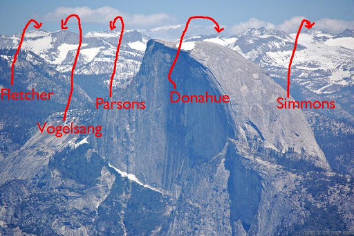
Can someone ID these things behind HD? I think I may be climbing some of them this summer.
Sorry about the lousy light:


Clouds in the way, but this light is nicer:


More better:


For all the postholers in the house, more here:
http://www.qitnl.com/v/061211/

Finally, a look south.

Taft Point at sunset:


Bridalveil:


Staring down Middle Cathedral:


From top:


To bottom:


More of that here:
http://www.qitnl.com/v/061311/
Re: Photos from El Cap June 11-13
June 19, 2011 04:48PM
Cool shots!
Re: Photos from El Cap June 11-13
June 19, 2011 07:11PM
Very nice!!! Can't wait til Thursday!
avatar Re: Photos from El Cap June 11-13
June 20, 2011 11:18AM
edit: <my response on the peaks was here... reworking that...>

Went to top o Ribbon last year in April, if interested some here:
https://picasaweb.google.com/yosemite.chick.on/Ribbon

I like the one of Middle. Gotta go up there. And also Horsetail. Wanna hike to the top o that one...


Chick-on is looking at you!


Edited 1 time(s). Last edit at 06/20/2011 11:29AM by chick-on.
avatar Re: Photos from El Cap June 11-13
June 20, 2011 11:42AM
Not 100% certain of Donahue and Fletcher... but they fit the picture...


Chick-on is looking at you!
avatar Re: Photos from El Cap June 11-13
June 20, 2011 03:09PM
Thanks for the ID - that confirms my suspicions but I wasn't quite sure what I was looking at. I plan to hit the Vogelsang/Parsons/Fletcher area later this summer.
Re: Photos from El Cap June 11-13
September 10, 2011 05:59PM
Very nice photos! I've never seen Horsetail Falls before. Which route did you take to the top, btw? I'm thinking about cross-countrying there, a straight shot from Tioga Road. Looks really doable without much elevation change. Gotta find the marker too.
Re: Photos from El Cap June 11-13
September 10, 2011 07:28PM
Quote
Ohnivy-Drak
Very nice photos! I've never seen Horsetail Falls before. Which route did you take to the top, btw? I'm thinking about cross-countrying there, a straight shot from Tioga Road. Looks really doable without much elevation change. Gotta find the marker too.

Surely you jest. The Horsetail Falls in Yosemite flows over the rim of El Capitan at about the 6200 foot level.
See http://mapper.acme.com/?ll=37.73147,-119.62890&z=15&t=T&marker0=37.73147%2C-119.62890%2C1.0%20km%20ExSE%20of%20El%20Capitan%20CA
Give the map link a minute or two, for it to fill in the topo lines.

The fastest route to El Cap is up the Yosemite Falls Trail, or come in from the west via the Foresta trailhead. You can hike down from Tioga Road, as you said, but it's a long day. see http://yosemitenews.info/forum/read.php?3,26797,26797 Or you can hike the trail along Yosemite Creek, then take the spur past Eagle Peak to El Capitan. Either way, you've got a two or three thousand foot descent from a Tioga Pass entry before you get to the lip of the falls, and then you still have to get home afterwards.
Re: Photos from El Cap June 11-13
September 11, 2011 11:42AM
Quote
Ohnivy-Drak
Very nice photos! I've never seen Horsetail Falls before. Which route did you take to the top, btw? I'm thinking about cross-countrying there, a straight shot from Tioga Road. Looks really doable without much elevation change. Gotta find the marker too.
Horsetail fall is so small, unless you know where to look, you won't see it most of the time.
avatar Re: Photos from El Cap June 11-13
September 11, 2011 08:50PM
Thanks. I came up from Yosemite Falls, the Tioga Road had yet to open. The trail at the rim was still covered in snow so I just followed the contour around Eagle Peak, which turned out to be a shortcut and a lot more fun.
Sorry, only registered users may post in this forum.

Click here to login