I am looking for information about this route: Hiking the South Fork Merced River upstream from Wawona to Gravelly Ford.
If anyone has traveled this route, I would very much appreciate any descriptions or information you can provide.
It appears on the map as if there may be difficulties.
Thanks,
- K

The Moon is Waxing Gibbous (83% of Full)
Re: S. Fork Merced - Upstream from Wawona
All posts are those of the individual authors and the owner
of this site does not endorse them. Content should be considered opinion
and not fact until verified independently.
|
S. Fork Merced - Upstream from Wawona July 14, 2011 03:14PM | Registered: 12 years ago Posts: 22 |
July 14, 2011 05:56PM | Registered: 14 years ago Posts: 7,421 |
I'll say something in the highly probable case no one else does...
Uh... uh... with high water... uh... uh... no way you make it to Gravely Ford
Well, I certainly wouldn't attempt it.
You could make it to Crescent Creek probably w/o much issue... but from Crescent Creek to Iron Creek
there is a major squeeze spot that w/o being able to cross the River... you are probably hosed.
The section from Iron Creek to Gravely Ford would also be impossible in high water imo.
It sure looks like fun though in lower water. I wonder if anyone has taken a Kayak down it from Quartz TH.
Why not bop down from Quartz Mtn TH? Or go down Iron Creek? And take a peek...
Guarantee you that the river is screaming now. I've only gone over Gravely late in the year... would be interested to see it now.
Anyone ...
(btw... I love these kinda queries)
* I haven't done this route... but there are few I haven't looked at...
|
Re: S. Fork Merced - Upstream from Wawona July 14, 2011 11:01PM | Registered: 12 years ago Posts: 22 |
Thanks. Yeah, that water stuff might be in the way.
I'm planning a long journey in early August.
One segment is from The Valley to Chiquito Pass, and I'm trying to choose an interesting, westside route.
What if I just followed the south shore of the river, up from Wawona, so I wouldn't have to cross it.
Those squeeze spots, cliffs, and bushes still might be prohibitive.
But I thought there was a chance that someone had gone up there and would know if it goes.
July 15, 2011 06:43AM | Registered: 14 years ago Posts: 7,421 |
Unless the water is really low there is no way you will get to Iron Creek from Wawona staying on the south side.
I wouldn't count on the water being low enough in early August this year. But I guess it is possible.
What is your route? Up Merced and Over Post and Fernandez? Over Red Peak Pass?
Why Chiquito? (I presume it's the former route... )
Regardless, the south is not super popular it seems but there's a number of great things down there.
Lots of great ridges with great views.
Trail location in spots again... is for taking you from pt. A to pt. B... not for enjoying the best of the journey imho.
July 15, 2011 08:42AM | Registered: 14 years ago Posts: 7,421 |

|
Re: S. Fork Merced - Upstream from Wawona July 15, 2011 04:56PM | Registered: 12 years ago Posts: 22 |
|
Re: S. Fork Merced - Upstream from Wawona August 24, 2011 02:40PM | Registered: 12 years ago Posts: 22 |
Here's a little follow up...
August 1, 2011.
Approximate flow 180 cfs.
Shortly after the swinging bridge:
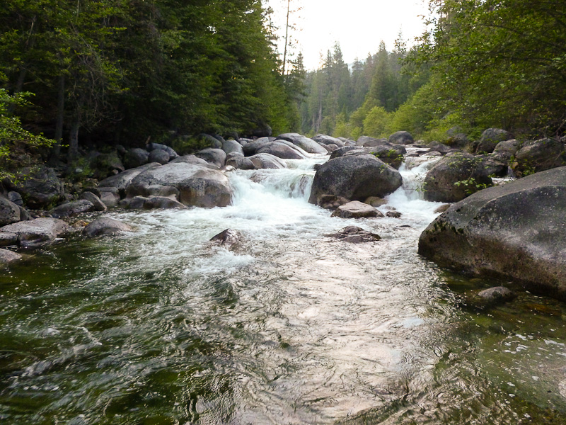
...the bushwhacking got intense. Steep slide slope with loose dirt and heavy growth. Or cliffy.
Here's some images:
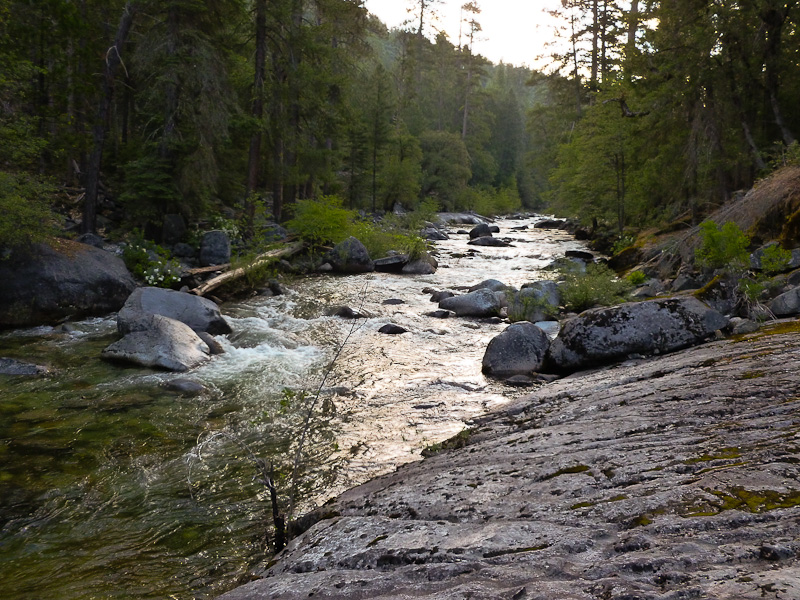
Generally the travel along the south bank was difficult.
Some would probably describe it as unpleasant, ridiculous, or idiotic.
I made about 5 river miles in 7.5 hours, and was working hard the whole time.
The north bank looked worse, with a lot more, and taller, cliffs.
I cannot recommend this route unless the water level allows walking in the bed.
At which time I can image this to be a very enjoyable trip.
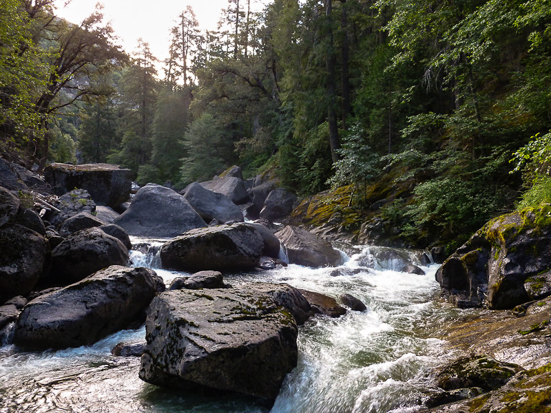
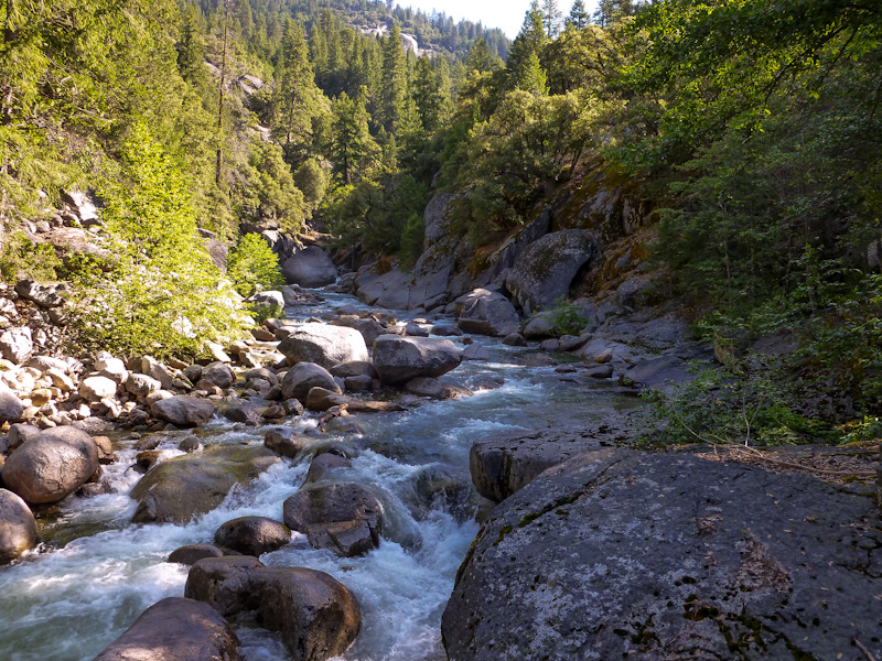
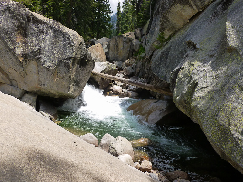
Then, at the base at the cliffs visible in the photo provided above by Mr. Chick-on, immediately west of Iron Creek, the canyon constricted impassably:
After some 4th class recon around the slabs, I found no way through this area at river level.
(Probably goes ok at low water)
There appeared to be several options for climbing 800 feet over the top and south of this obstacle.
I choose to escape the river entirely, cross over and climb the north wall to Crescent Lake.
As this gave me the best chance to rejoin my intended route on schedule.
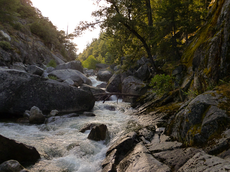
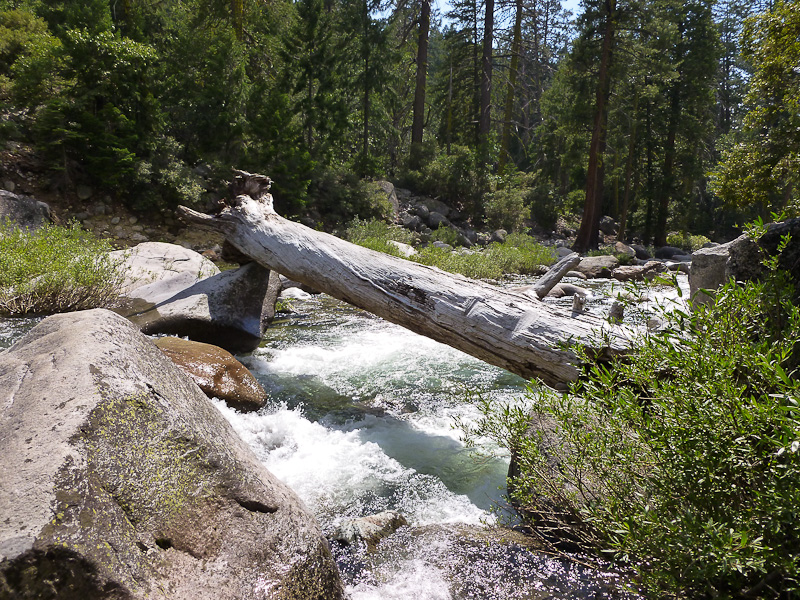
My bridge, near river mile 30:
The ascent of upper Crescent Creek was steep and loose hiking, but straightforward. Definitely best on the west side.
This was a great little diversion to a rarely visited place. It is interesting to me that a trail was never built in this valley.
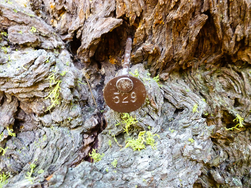
I only saw one sign of humans. Around river mile 27 or 28, about 100 feet above the water. Amidst thick forest with no trail in sight:
Enjoy.
(fixed links 3/24/12)
Edited 1 time(s). Last edit at 03/24/2012 07:28PM by Klas.
August 1, 2011.
Approximate flow 180 cfs.
Shortly after the swinging bridge:
...the bushwhacking got intense. Steep slide slope with loose dirt and heavy growth. Or cliffy.
Here's some images:
Generally the travel along the south bank was difficult.
Some would probably describe it as unpleasant, ridiculous, or idiotic.
I made about 5 river miles in 7.5 hours, and was working hard the whole time.
The north bank looked worse, with a lot more, and taller, cliffs.
I cannot recommend this route unless the water level allows walking in the bed.
At which time I can image this to be a very enjoyable trip.
Then, at the base at the cliffs visible in the photo provided above by Mr. Chick-on, immediately west of Iron Creek, the canyon constricted impassably:
After some 4th class recon around the slabs, I found no way through this area at river level.
(Probably goes ok at low water)
There appeared to be several options for climbing 800 feet over the top and south of this obstacle.
I choose to escape the river entirely, cross over and climb the north wall to Crescent Lake.
As this gave me the best chance to rejoin my intended route on schedule.
My bridge, near river mile 30:
The ascent of upper Crescent Creek was steep and loose hiking, but straightforward. Definitely best on the west side.
This was a great little diversion to a rarely visited place. It is interesting to me that a trail was never built in this valley.
I only saw one sign of humans. Around river mile 27 or 28, about 100 feet above the water. Amidst thick forest with no trail in sight:
Enjoy.
(fixed links 3/24/12)
Edited 1 time(s). Last edit at 03/24/2012 07:28PM by Klas.
August 24, 2011 04:04PM | Registered: 14 years ago Posts: 7,421 |
Sweet. You still had a long a way to go to Gravely (about 4 miles).
Actually it sounds right up my alley. I sorta got the feeling you thought I was full of it...
so I never did mention anything about maybe walking the ridge to Mt. Raymond after
taking the trail thru Mariposo Grove from Wawona.
After looking some more now... I kinda wanna do that and drop down to the river and
check out BM 6402 and the squeeze spot. Looks very impressive. Muir Gorge-like.
Then again the area east of the squeeze looks incredibly interesting.
Anyway, two questions.
a - was there any poison oak to contend with?
b - so did you just go up Horse Thief Canyon and up and over Triple Divide and skip Sing/Gale? or wutt?
I've seen the tree markers in a couple of other spots in the park. If there's one... usually there is
a large number. at least that is what I have seen. Not sure how exactly they are used to
monitor the forest though.
Thanks so much for coming back and sharing your experience
|
Re: S. Fork Merced - Upstream from Wawona August 24, 2011 09:21PM | Registered: 12 years ago Posts: 22 |
Actually, while planning ahead I had seriously considered the ridge over Mt. Raymond. Ultimately I went with the river... I would like to try the Mt. Raymond route, the ridge looked walkable from Crescent Lake, have you done it?
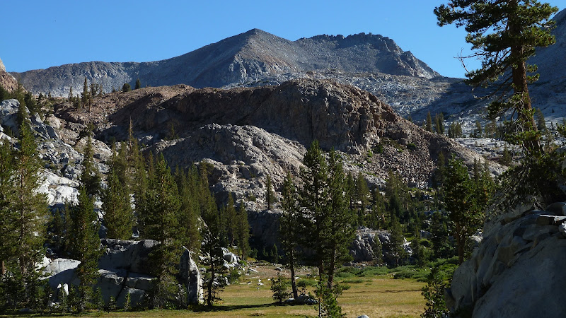
Regarding BM6402, it is super. Here's a shot:
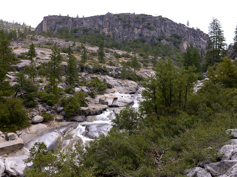
The squeeze spot is created by BM6402 on the north, and the slabby "dome" (seen in your photo above) to the south. These two formations make an interesting contrast. The south dome is light colored granite, exfoliated, round and smooth. BM6402 looks older, a blocky vertical fortress of dark rock. They stare at each other across the river. I would like to ask a geologist.
A) Only saw poison oak a few times, was not an issue.
B) After camping below Crescent Lake, at 6,000' see map above "Camp2", I followed trail... Buck Camp - Moraine Meadows - Breeze Lake, and yes skipped Sing/Gale.
I continued the next day... Fernandez Pass - ridge to Alpine Lake Saddle - 10,200 contour around point 10,518 - up and over Triple Divide.
Or in other words, back through this:
(fixed links 3/24/12)
Edited 1 time(s). Last edit at 03/24/2012 07:30PM by Klas.
Regarding BM6402, it is super. Here's a shot:
The squeeze spot is created by BM6402 on the north, and the slabby "dome" (seen in your photo above) to the south. These two formations make an interesting contrast. The south dome is light colored granite, exfoliated, round and smooth. BM6402 looks older, a blocky vertical fortress of dark rock. They stare at each other across the river. I would like to ask a geologist.
A) Only saw poison oak a few times, was not an issue.
B) After camping below Crescent Lake, at 6,000' see map above "Camp2", I followed trail... Buck Camp - Moraine Meadows - Breeze Lake, and yes skipped Sing/Gale.
I continued the next day... Fernandez Pass - ridge to Alpine Lake Saddle - 10,200 contour around point 10,518 - up and over Triple Divide.
Or in other words, back through this:
(fixed links 3/24/12)
Edited 1 time(s). Last edit at 03/24/2012 07:30PM by Klas.
August 24, 2011 11:13PM | Registered: 12 years ago Posts: 343 |
August 25, 2011 06:50AM | Registered: 14 years ago Posts: 7,421 |
Yeah. Nice!
The meadowy area down on the right there... that is Horse Thief Canyon.
Pretty little known gem of Yosemite.
Here's TD from there:
maybe you have the same photo-ish?
Haven't done Raymond. Or TD for that matter. (have done Gale/Sing/Merced Pk though... )
The loop from Wawona->Mariposa Grove->Raymond Ridge->BM6402->Crescent->Crescent Ridge to Wawona Dome->Trail looks sweet.
Raymond Ridge looks pretty straightforward. Crescent Ridge I've done some of and is nice too.
Too much schtuff to do! Gonna snow too soon... o well... there's next year, right?
Have fun and thanks
Sorry, only registered users may post in this forum.

