Why is it always open? Because after you get to Lake Elizabeth, it will require about four miles of hiking off a maintained trail to get to Nelson Lake. And most people just aren’t comfortable doing that. The irony is that the first three miles of that “off-trail” adventure are on a pretty darn clear use trail. It’s only the last mile that gets a little confusing. But if you know how to read a map, you can’t miss the lake.
Day One: We left August 12 and got a very quick version of the permit spiel—probably because they could see on their computer that this was not our first permit. The smoke from the controlled burn at Crane Flat made the sky muggy on the drive to TM, and then we got into the smoke from the Glacier Point Fire. Sigh.
Still, it was a sunny day, and we were on the trail! The hike up to the pass into Nelson Lake takes you to the end of the meadow, and then straight up the right-hand (West) side of the canyon. Near the top the trail got a little blurry at a stream crossing (what’s new?) but we picked it up again as we neared the top of the ridge. For those interested in following along at home, you always want to aim at the lowest point on the right-hand side of this ridge of Unicorn Peak. )
There were some nice views from the pass here, but the smoke gave them a slightly dingy tint.
The trail down the canyon was even easier to follow, about two miles down to the end of the granite outcropping on the left side of the canyon. At this point the trail gets murky, and we simply followed our maps up and over a couple of ridges and up into Nelson lake. (It lies directly between two major domes/ridges, so it can’t really get lost!)
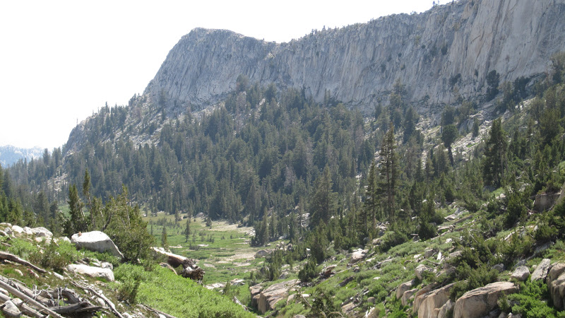
Echo Canyon
Nelson is a beautiful lake with a huge meadow at the northeast end and walls of granite on the south side. Did we mention the meadow? Because the mosquitoes here were horrific. We had picked a spot that we thought would get enough breeze to blow them away, only to discover that they were flying in clouds and landing on the leeward side of each of us. And then the wind died.
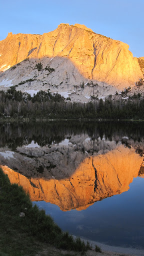
Nelson Lake
We were in our tents by 8 p.m. with our headnets ready for the next morning. Nice sunset, by the way.
Day Two: And the bugs were back the next morning as well. A quick breakfast and we waltzed up the ca
nyon along the edge of the meadow towards Reymann Lake. From Nelson this looked like we might hit a wall or two of granite, but we kept to the right side of the canyon, and it was a piece of cake. A few nice granite slabs led us to an overview of Nelson behind us. And in front of us, Reymann Lake, surrounded by meadow.
Reymann Lake
Yep. The mosquitoes here were even worse. Even in the middle of the morning, bright sun, they were everywhere. We inhaled some, put headnets on, and climbed past Reymann Lake, this time keeping to the trees on the far left-hand side of the pass. This turned out to be the perfect approach, and led us neatly into the pass over the saddle between Rafferty and Johnson Peaks. (Both peaks looked pretty easy to climb from this ridge, for those of you who are peak baggers!) Great views here, and from the saddle we could see Rafferty Canyon below. But we could also see a ridge to our southeast that looked perfectly doable…and would lead us more directly towards Tuolumne Pass.

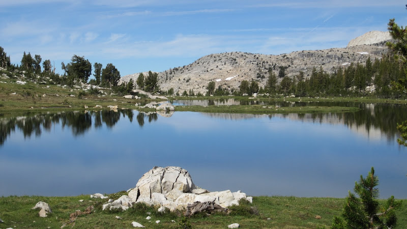
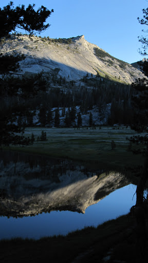
Evelyn Lake
That hike, traversing across the high slopes of Rafferty Peak, led us to some amazing views of Yosemite’s High Country. Wonderful stuff at 10,000 feet.
From the top of the next saddle, we could see the Rafferty Creek Trail wending along through the meadow about 1,000 feet below. But instead of heading straight down to the trail and then hiking back up to Tuolumne Pass, we decided to head straight towards the pass itself. This meant more off-trail travel, but after we got down the first step section of granite, it was really a pleasant hike. And my navigation was pretty accurate—we hit the trail about 500 from Tuolumne Pass itself.
The rest of the trip was on established trails, but that didn’t mean it wasn’t fun. We passed through the urban core of Vogelsang High Sierra Camp (filled the water bottles with no filtering!) and then headed up over Vogelsang Pass. Here again the Glacier Point Fire made the views seem smoggy---too bad, because Vogelsang has spectacular views. But we could clearly see Bernice Lake, our campsite that night, hanging over the edge of Lewis Canyon.
We met a lot of people on the back side of Vogelsang Pass, most of them without packs, hiking from HSC to HSC. And many of them seemed to be suffering! (We did meet two charming Swiss women at Tuolumne Pass who were day-hiking up Rafferty, across Evelyn, and then down Lyell…and they were really enjoying it, God bless them.)
We camped way up on the West ridge above Bernice Lake, hoping to get into the wind and away from the mosquitoes. That didn’t work, and even though I saw a lot of fish rising on the lake below, I couldn’t convince myself that fishing for them was going to be fun. We watched the sun set through headnets and went to bed early again. The roar of the big waterfall on the far side of the lake serenaded us all night long.
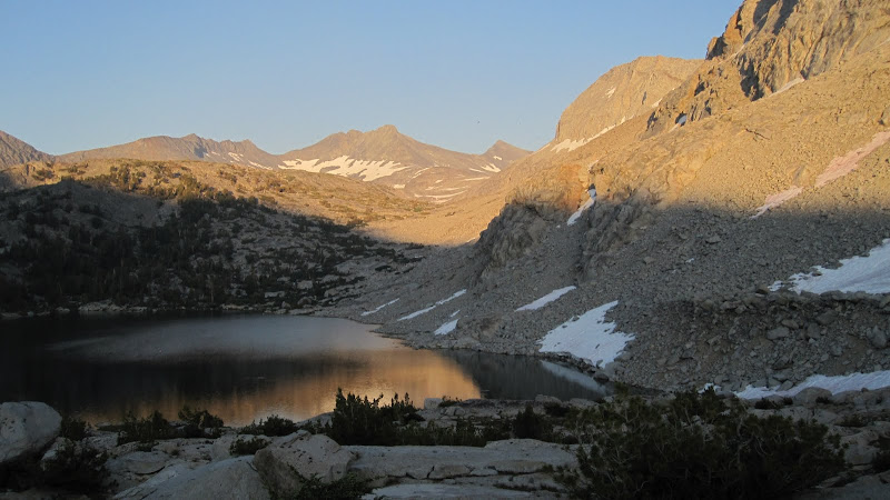
Bernice Lake
Day three: The next morning things were a little different. For one thing, the temperatures had dropped just a bit, and the bugs were a bit chilled. And the smoke from the fire was gone, so that we ate breakfast with a clear view of the Clark Range sparkling in the morning sun. And then we hiked down from Bernice Lake and down Lewis Canyon. Clouds were blowing in from the south, and at times it looked as if it might rain. Lewis Creek kept us company the whole way down, and this was the beginning of the best part of the trip. From the expansive views of the High Country, we now hiked through forests and waterfalls, (Florence Creek was perfect!) flowers and fungi, hidden pools and cascades.
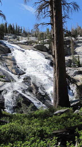
Florence Creek Falls
A great hike, ending with somewhat smoky views of Merced Lake and Half Dome.
Once down at the junction, we crossed Lewis Creek and climbed up the granite on the east side of Fletcher Creek. We were still a bit worried about rain, but the sun came out, the wind still blew, and the trail followed the wonderful four miles of waterslide that is Fletcher Creek. The views down canyon towards the Merced and across the way towards the Clark Range were amazing.

Clark Range from Fletcher Canyon
Once at the top, we broke out into the meadows below Tuolumne Pass, snapping photos all the way, and hiked up into Emeric Lake.
This is a beautiful Lake, but camping here is problematic. We finally settled on a site on the ridge above the lake's eastern shore. (Shaffer’s trail guide suggests entering this basin from below, by crossing Fletcher Creek and following Emeric’s outlet steam up the granite to the lake. But in this wild water year, there was no way we were going to try to cross Fletcher Creek in that area—we might have ended up in Merced Lake!) The best campsites were clearly on the far side of the lake, but we didn’t feel like clambering over the huge talus blocks or crossing the bug infested meadows, to get there.
Still, the wind shift, the cooler temperatures, and maybe the change of scenery had reduced the mosquito population to a bearable number, and we really enjoyed this evening. Before sunset, we walked up to the top of the ridge where we were camped, and watched the sunset on Vogelsang and other peaks.
Emeric Lake
Day Four: A perfect day. We hit the trail early, and simply loved the hike up to Tuolumne Pass through alpine ponds, trees, Boothe Lake, meadows, and high peaks all around. And then the trail slowly dipped down through the high meadows, and the peaks slowly disappeared as we descended into Rafferty Canyon. We loved the tiny waterfall about half-way down, and found a great lunch spot beside the creek and off the trail.

Cascade on Rafferty Creek
All of a sudden, after lunch, we were back in the land of the hikers. We had seen only a few people (outside of Vogelsang Pass) for the last three days, but now we were meeting a new group every few hundred yards. Some seemed pretty much out of their element, and others were obviously enjoying things. One group was arguing about whether or not to treat their water (and asked us to referee!) another group was resting in the shade; other groups were huffing and puffing up the climb.
We did worry about one small girl in a Boy Scout group who was flushed, gasping and clearly overheated and dehydrated…and many of the people seemed unprepared to hike the whole way to Vogelsang—which was the destination for most of the groups. One couple, clearly experienced, were on their way up Lyell Canyon to Donahue Pass with smiles on their faces. Sweet.
It was an easy walk back along the Tuolumne to the campground. Back to the car, back to town, and back to showers. And stories to tell.
You can see the photos on our Picasa page, here:
https://picasaweb.google.com/balzaccom/YosemiteNelsonBerniceAndEmericLakes#
Check our our website: http://www.backpackthesierra.com/
Or just read a good mystery novel set in the Sierra; https://www.amazon.com/Danger-Falling-Rocks-Paul-Wagner/dp/0984884963


