
Edited 1 time(s). Last edit at 08/16/2011 09:37PM by Ohnivy-Drak.
|
Ahwiyah Point August 16, 2011 09:35PM | Registered: 13 years ago Posts: 931 |
August 17, 2011 07:34AM | Registered: 14 years ago Posts: 7,421 |


|
Re: Ahwiyah Point August 17, 2011 05:00PM | Registered: 14 years ago Posts: 755 |
Quote
chick-on
From what I pretend I know...
You go up the Half Dome Slabs to NW face .. and it's all more or less class 3-ish.
Ahwiyah and Bushido Gully from what I have heard are class 3.
I wouldn't go without a rope... even though there will prob. be fixed ropes already
in places.
(what you should really take from this is... it's prob. closer to class 4... and
you should go and ask at the mountaineering place in Curry)
wherever will chime in... now
I wanna go up Bushido and down other side some day... but there is just tooooooo
much to doooooo out there!!!!!!!!! not gonna do 1/2 of what I had planned this yr.
|
Re: Ahwiyah Point August 17, 2011 05:27PM | Registered: 13 years ago Posts: 931 |
Quote
wherever
Quote
chick-on
From what I pretend I know...
You go up the Half Dome Slabs to NW face .. and it's all more or less class 3-ish.
Ahwiyah and Bushido Gully from what I have heard are class 3.
I wouldn't go without a rope... even though there will prob. be fixed ropes already
in places.
(what you should really take from this is... it's prob. closer to class 4... and
you should go and ask at the mountaineering place in Curry)
wherever will chime in... now
I wanna go up Bushido and down other side some day... but there is just tooooooo
much to doooooo out there!!!!!!!!! not gonna do 1/2 of what I had planned this yr.
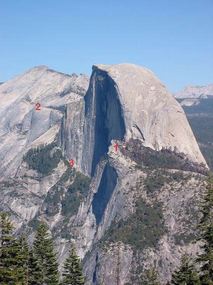
As ordered: Yeah, I've poked around up there. Never been actually on top of the thing. Tough brushy ledges and probably class four, but the real problem is that there is no need to go there. The rounded top means that you can't see the fabulous sheer cliff below you. The view from there of the face of Half Dome is good, but the view from the wooded ridge above it is just as good. The view of Tenaya Canyon is no better than from Quarter Domes and the Diving Board.
If you still want to go over there, I would recommend the following: Take the Half Dome trail to the start of the steps on the subdome, then follow the climbers trail down to the bottom of the face. From there, go over to the grove above Ahwiyah Point and go out as far you you want for views, then come back and follow the big ledge at the base of the face as far as it goes. Get your pics and return home.
Or continue up the class four route to the Diving Board, but remember that it takes longer than you might think. At the end of the face ledge, you have to bushwhack down a couple of hundred feet to get to the western end of the face, and it is a long, exposed scramble up to the Diving Board. I would never do it without a rope. Also be warned that the gully that you are ascending (Which I hear that the whippersnappers call Bushido...Roper never called it that!) is famous for holding ice well into summer.
|
Re: Ahwiyah Point August 17, 2011 06:46PM | Registered: 14 years ago Posts: 755 |
Quote
Ohnivy-Drak
[According to a climbers forum on supertopo.com, there's a zig-zag route up the NE Gully which the author considered Class 3. Looks dangerous in any season. I was just curious if anyone has been to the top. I've never seen a photo of anyone up there.
I also thought about your suggested route, going around and down from Subdome. Not that I would ever attempt it, but maybe it's for "Chicks" and "Burds"
Diving Board is on my list, looks doable. Not sure about looking directly down though...


August 18, 2011 08:03AM | Registered: 12 years ago Posts: 254 |
|
Re: Ahwiyah Point August 18, 2011 08:22AM | Registered: 14 years ago Posts: 755 |
Quote
Hitech
Quote
wherever
It's easy enough...
I'm guessing we have different ideas of easy.
|
Re: Ahwiyah Point August 18, 2011 01:43PM | Registered: 13 years ago Posts: 931 |
August 18, 2011 02:09PM | Registered: 15 years ago Posts: 4,173 |
August 18, 2011 04:45PM | Registered: 15 years ago Posts: 670 |
Quote
plawrence
By any chance has anyone gone up to the Diving Board via the Le Conte Gully route from Happy Isle? Supposedly that was the route that Ansel Adams took when he went up there to shoot his famous photo, "The Monolith".
Summit.org: Le Conte Gully route
August 18, 2011 05:23PM | Registered: 12 years ago Posts: 343 |
August 18, 2011 06:53PM | Registered: 14 years ago Posts: 7,421 |
|
Re: Ahwiyah Point August 18, 2011 02:44PM | Registered: 14 years ago Posts: 755 |
Quote
Ohnivy-Drak
Wow. This route to the DB is out of my league. From which way did you get back down? Via the usual Lost Lake route?
August 18, 2011 02:50PM | Registered: 12 years ago Posts: 254 |
|
Re: Ahwiyah Point August 18, 2011 07:00PM | Registered: 14 years ago Posts: 755 |
Quote
Hitech
ANYTHING requiring ropes is not easy. Especially since I have no climbing training!
|
Re: Ahwiyah Point September 23, 2011 11:11PM | Registered: 13 years ago Posts: 931 |
Quote
wherever
Quote
Hitech
ANYTHING requiring ropes is not easy. Especially since I have no climbing training!
OK. Stay away from the Death Slabs approach from Mirror Lake. You should be able to follow the climbers trail down from the subdome, as I described. Gawk at the face, explore the ledge and the grove, and go back the way you came....
September 25, 2011 09:19PM | Registered: 15 years ago Posts: 4,173 |
Quote
Ohnivy-Drak
A nice report from one of the crazies.
http://www.snwburd.com/bob/trip_reports/clouds_rest_3.html

August 18, 2011 07:23PM | Registered: 12 years ago Posts: 343 |
August 18, 2011 09:34PM | Registered: 15 years ago Posts: 4,173 |
|
Re: Ahwiyah Point September 26, 2011 07:27PM | Registered: 12 years ago Posts: 285 |
Quote
plawrence
Thanks for the link to that 1940 Guide.
Here's the one paragraph excerpt it has about Le Conte Gully (It rates it a Class 4 because of one 25' Class 4 pitch, the rest is just Class 2 rock scramble):
September 27, 2011 10:39AM | Registered: 14 years ago Posts: 7,421 |
September 27, 2011 07:21PM | Registered: 12 years ago Posts: 343 |
September 27, 2011 08:29PM | Registered: 14 years ago Posts: 7,421 |
|
Re: Ahwiyah Point October 12, 2011 09:46PM | Registered: 12 years ago Posts: 285 |
no not yet, just ment that there is a clear path that breaks off from the sierra point trail that fits the decription for leConte GullyQuote
chick-on
Quote
ryanmj
the route is clear where it breaks off from sierra point, deffinetly has gotten use in the last few years but I dont know what the difficulty is.
Are you saying you went up LeConte? And it was easy? Or what?
September 27, 2011 09:08PM | Registered: 15 years ago Posts: 670 |
September 27, 2011 09:26PM | Registered: 12 years ago Posts: 343 |
|
Re: Ahwiyah Point October 12, 2011 09:48PM | Registered: 12 years ago Posts: 285 |
Quote
QITNL
I'm not sure of the points you reference, but when you get there, the turn is pretty obvious. You wiggle up all the garbage until you hit the wall and the trail to Sierra Point takes a hard right. You go hard left to LeConte and can follow a faint use trail for a while.
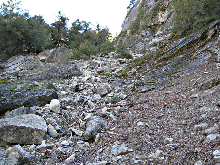
One other trick, at the base of the route to SP: after you turn off the freeway and clamber through the initial rockpile, head to the right as soon as possible. Get off the big blocks as soon as you can, maybe thirty yards or so. The use trail begins there, way down low. I always see some knuckleheads spending hours wading up through that talus and say see you later, pals.
|
Re: Ahwiyah Point October 13, 2011 09:58AM | Registered: 13 years ago Posts: 864 |
October 13, 2011 12:29PM | Registered: 12 years ago Posts: 343 |


