
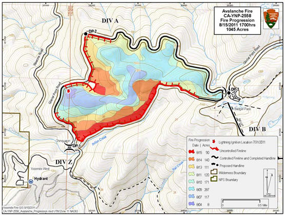
Avalanche Fire: (37 39.794 x 119 42.238; 6,400 feet, Mariposa Co.) This lightning caused fire has been burning in Yosemite National Park since it was discovered on the afternoon of July 31, 2011. The fire was observed during a reconnaissance flight near Avalanche Creek and Glacier Point Road within Yosemite’s Congressionally designated wilderness area. Due to a strong high pressure weather system, poor smoke air dispersion and potential negative smoke impacts the fire is being held at 1,045 acres.
Smoke is visible from the Valley, Glacier Point Road and in the direction of transport winds. Park fire managers and firefighters are sensitive to smoke, visitation, and human health concerns and therefore diligently timed burning operations to coincide with optimal smoke dispersion. The park is collaborating with the Mariposa County Air Pollution Control District (MCAPCD) by communicating daily concerning potential air quality impacts, mitigations, and to support each agency’s responsibility to public health.
Air monitoring equipment is installed within Yosemite West, El Portal and Yosemite Valley to obtain daily air quality levels. Landscape features have been identified as management action points within the fire perimeter to limit the fire’s spread. The fire line is along roads, trails, and previous fire footprints. Actions may be used by firefighters to minimize and reduce smoke impacts, such as helicopter water drops to cool portions of the fire.
Smoke continues to be present along the roadways. As firefighters and fire equipment work along the roads, drivers are urged to adhere to posted 25 mph speed limits, possible single lane closures and traffic officer instructions.
The fire has backed down to the Chinquapin facility and along the Glacier Point Road portion of the fire perimeter. The fire is being held along the historic Old Glacier Point Road to the south. Eighty-five firefighters and managers are committed to the fire, including units from the USFS and BLM. Fire resources are also being released from the fire.
Combined with previous fires, roadside mechanical thinning, vegetation debris pile burning, and prescribed fires, this fire is providing a defensible fire buffer to the communities of Yosemite West, Badger Pass Ski Resort, Glacier Point and other park infrastructures. Although numerous fires have occurred adjacent, the most recent being the 2009, 3,500-acre Grouse Fire, this area has no recorded fire history. Extensive logging did occur in the early 1900s.
Managing naturally occurring lightning fires is consistent with the current Yosemite Fire management Plan and Environmental Impact Statement.
Bald Fire: (37 50.823 x 119 47.434, approximate 6,200-foot elevation, Tuolumne Co.): Reported on June 24 by the Yosemite helitack and Stanislaus National Forest’s Pilot and Smith Peak fire look-outs, fire managers believe this was a lightning-caused fire started during a June 5 thunderstorm. Firefighters declared the 210-acre fire contained at 2 p.m. June 29. Rain and snow fell onto the fire perimeter on June 29, adding up to more than 2.5 inches of precipitation. The fire occurred in designated Wilderness but is within a zone where fires are put out due to threats to property, structures and other infrastructures. The fire was approximately 1.5 miles northwest of the community of Aspen Valley. Yosemite firefighters were assisted by Hot Shot crews from the Sequoia, Los Padres and Stanislaus national forests and Sequoia & Kings Canyon National Parks.
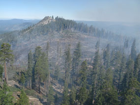
Ground fire effects show around Bald Mountain.
Many fires have occurred in this area over the years due to lightning, the largest being the 1996 Ackerson Fire that burned more than 60,000 acres in the park. The fire was burning in a remote area, where the terrain was steep and rugged. Minimum Impact Suppression Tactics were used by firefighters to minimize impacts to wilderness; this includes, for example, the use of natural fires breaks of rock areas rather than cutting hand lines.
Bald’s Fire Effects: The photo is a good representation of perfect fire effects—the essence of what fire mangers and ecologists want. The Bald Fire is essentially a ground fire cleaning the forest floor of an overabundance of vegetation. This fire has opened the forest canopy and surface of fuels, setting an ideal mosaic for the ground. An overaccumulation grew after the 1996 Ackerson Fire, demonstrating a need for the return of fire and how fire benefits the ground. Although the Bald Fire is a suppression fire, the park still gained ecological effects.
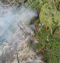
In the Bald Fire, an overaccumulation of mountain whitethorn (Ceanothus cordulatus) burns through the vegetation.
Edited 1 time(s). Last edit at 08/17/2011 04:56PM by eeek.

