Does anybody have any maps (maybe chick-on?) that would show roads like the old/new Wawona on the same quad sheet or something similar? Maybe even just the old or new 'hand drawn" onto the older/newer version of the road. I would love to see something "semi' official that shows both at the same time...its just a curiosity thing for me.
Thanks
All posts are those of the individual authors and the owner
of this site does not endorse them. Content should be considered opinion
and not fact until verified independently.
|
Older roads superimposed on newer roads September 16, 2011 08:08AM | Registered: 12 years ago Posts: 23 |
|
Re: Older roads superimposed on newer roads September 16, 2011 11:00AM | Registered: 12 years ago Posts: 259 |
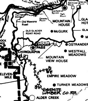
Went up the Old Wawona Rd last year. See below for a quick map I made of the road based on my GPS track. If you plan on hiking it, the road itself is pretty easy to follow most of the way. The 'start' or north point is by far the easiest place to start it, and it is just a few hundred yards up from the Bridalveil falls parking lot. The other end is near the long pullout on 41 but is almost impossible to see/find. After you reach the road's highest elevation, about 3/4's of it's length from Bridalveil, the road quickly becomes very overgrown. Thereafter it is somewhat hard to follow and involves a lot of bushwhacking.

|
Re: Older roads superimposed on newer roads September 16, 2011 01:41PM | Registered: 13 years ago Posts: 617 |
Quote
buster
Went up the Old Wawona Rd last year. See below for a quick map I made of the road based on my GPS track. If you plan on hiking it, the road itself is pretty easy to follow most of the way. The 'start' or north point is by far the easiest place to start it, and it is just a few hundred yards up from the Bridalveil falls parking lot. The other end is near the long pullout on 41 but is almost impossible to see/find. After you reach the road's highest elevation, about 3/4's of it's length from Bridalveil, the road quickly becomes very overgrown. Thereafter it is somewhat hard to follow and involves a lot of bushwhacking.
Actually, the other end is in Wawona. The close-to-Grouse-Creek point you mention is simply where it crosses the current alignment. If you cross over the road and poke around west of the current road, you'll find the remains of the bridge abutments where the road crossed Grouse Creek and, from there, the continuation of the road. I've not hiked the length of that section so I'm not sure where it comes back up but from here to at least Bishop Creek, it's mostly below (i.e., west of) or coincident with the current alignment. Another easy-to-find section starts a few hundred feet down Henness Ridge Road (the road that leads to Yosemite West) and hits the current road near Bishop Creek.
I've been meaning to create the sort of overlay maps you mention. You can do a very accurate one by getting old and new USGS maps, importing them in to Photoshop (or the equivalent), overlaying them, aligning them and then erasing everything except the road from one of the layers. Conceptually simple but quite time-consuming...maybe as those long winter nights settle in I'll get to it! Meanwhile, the Paden/Schlichtmann book I mentioned in this thread compares the old and new Big Oak Flat and (part of) Tioga Roads but the maps are hand-drawn and very approximate...they're good enough to guide you if you're on the roads but I certainly wouldn't trust them as gospel.
There's also an end-to-end (but again, only approximate) hand-drawn map in Keith Trexler's brief monograph about the Tioga Road
Tom Bopp (Wawona historian and long-time pianist at the Wawona Hotel) tells me he's done this exercise with the Wawona Road but he's working on a Wawona history book and is saving the map for that (in other words, he'll talk about it and give you detailed hints about where to find the road but doesn't want the map itself floating around). Of course, as he said to me last time we talked, "I'm happy to give you the clues but isn't it more fun to get out and find it yourself?" (I actually agree with that...just wish I lived closer to Yosemite so I didn't have to wait a year between trips!).
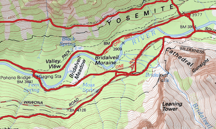
BTW, the Wawona Road is trickier to track than the others because when they built the new road, they intentionally "obliterated" (the word used in the superintendant reports of the period) parts of the old road to prevent people from using it (the stretch from BVF to Inspiration Point was left open as a "scenic drive" for a number of years but a bad storm year damaged parts of the IP approach and they decided to close the road at that point). FYI, the section of road slightly south of BVF is actually NOT the Valley end of the road. If you follow the line of the old road from here across the current road, you'll see where it continues briefly to the west of the current road. It only goes a couple of hundred feet before it gets completely confused and I wasn't able to figure out exactly where it came out (it looks like it might have looped back to the current road directly across from the current BVF parking lot entrance but I wouldn't swear to that). One more reason to create that overlay map!
There's also the old Glacier Point Road. From GP to a point a couple of miles east of Bridalveil CG, the current road uses the old alignment (this is where the road gets very narrow. I've not walked the remaining stretch of the old road but it's easy to find on current maps as pretty much the whole stretch is designated as various trails now.
October 23, 2011 06:38PM | Registered: 14 years ago Posts: 7,421 |
Dang, I missed this one. Great map by buster.
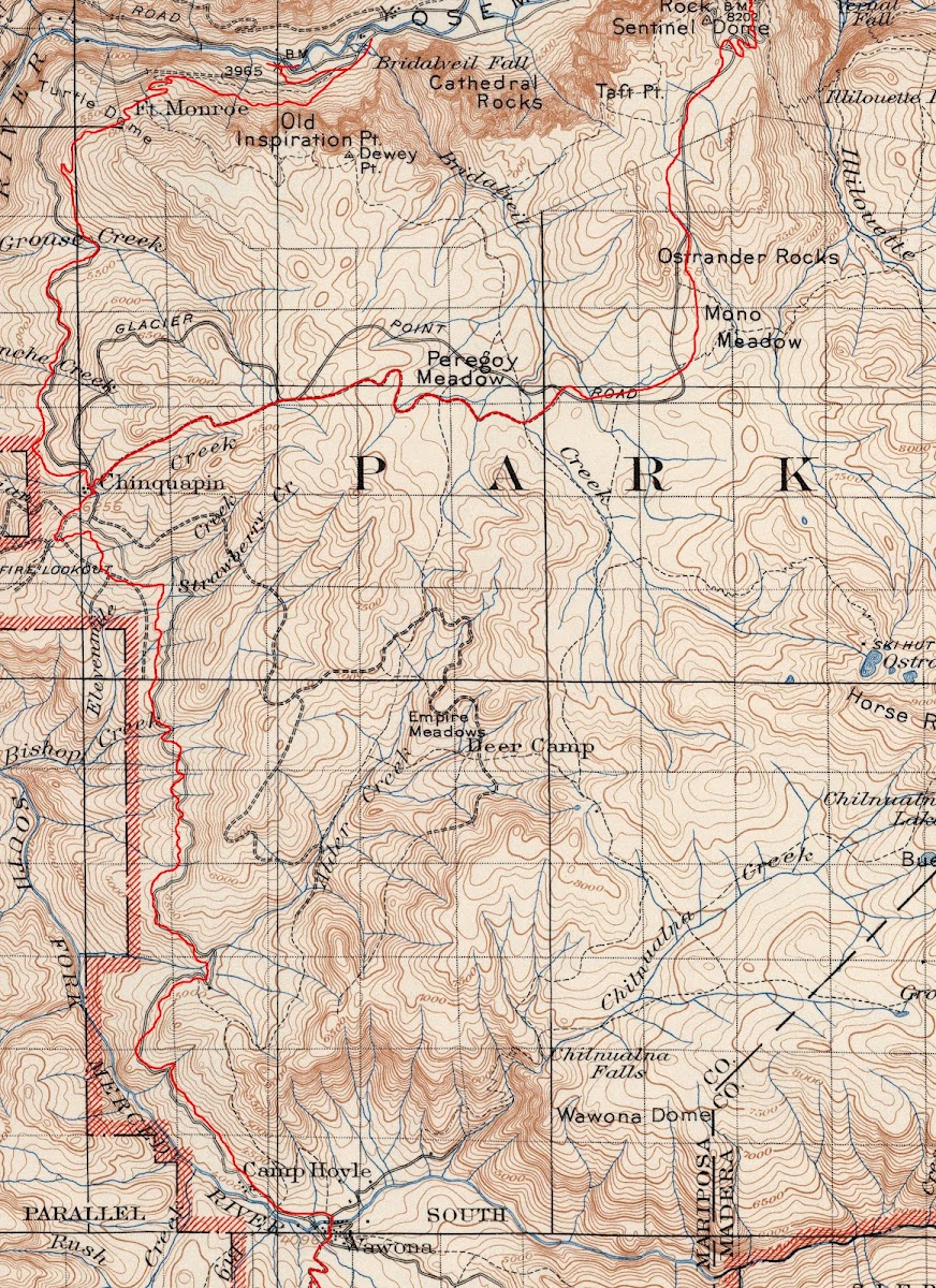
Superimposing a 1930's map onto USGS quad produces the same:

The area just south of Chinquapin some of that road is right on USGS. But there was also some
rail in that area from The Yosemite Lumber co. Was just in that area and was trying to figure out
where exactly it went in the past. Some of it is now trail and you can see cables and ties.
Other portions have been left to nature to retake. (the red in this map includes some of that
that I want to explore soon) Also w/r to that... there were buildings in Empire Meadow... but
I certainly didn't see them when I was there a few years ago.

Supposedly, according to "Yosemite Resources " by Linda Greene .. Wawona rd. south of
here follows the same path ... old vs. new:
i.e.:

Almost all of Tioga is on present USGS maps. It's just that it is now a trail perhaps.
Poke around here for more stuff:
https://picasaweb.google.com/yosemite.chick.on/YoseMaps
Have fun

Superimposing a 1930's map onto USGS quad produces the same:
The area just south of Chinquapin some of that road is right on USGS. But there was also some
rail in that area from The Yosemite Lumber co. Was just in that area and was trying to figure out
where exactly it went in the past. Some of it is now trail and you can see cables and ties.
Other portions have been left to nature to retake. (the red in this map includes some of that
that I want to explore soon) Also w/r to that... there were buildings in Empire Meadow... but
I certainly didn't see them when I was there a few years ago.
Supposedly, according to "Yosemite Resources " by Linda Greene .. Wawona rd. south of
here follows the same path ... old vs. new:
i.e.:
Almost all of Tioga is on present USGS maps. It's just that it is now a trail perhaps.
Poke around here for more stuff:
https://picasaweb.google.com/yosemite.chick.on/YoseMaps
Have fun
|
Re: Older roads superimposed on newer roads October 23, 2011 09:53PM | Registered: 14 years ago Posts: 755 |
In case the map above gives you the same squint that it gives me, try this link. Then use the magnifying glass icon, if your browser shrinks it to fit on the screen. It should then show up at 1600 pels wide.
https://lh3.googleusercontent.com/-sSRLq1R1cIA/TqRXogkMEdI/AAAAAAAAUEg/6IEhTeJ3gLg/s1600/chinq-overlay.JPG
https://lh3.googleusercontent.com/-sSRLq1R1cIA/TqRXogkMEdI/AAAAAAAAUEg/6IEhTeJ3gLg/s1600/chinq-overlay.JPG
October 24, 2011 07:07AM | Registered: 14 years ago Posts: 7,421 |
Here's another great map:
It's the only one I have been able to find that shows Yosemite Lumber Co. rail near Empire.
It also shows Old Badger Pass and Old Wawona Rd. Old BP is also on current USGS maps.
It's in great condition and is a Ski Trail from Chinquapin to Badger Pass. Actually the entire
stretch from Chinquapin to Bridalveil is a ski trail... of course you can hike these too.
|
Re: Older roads superimposed on newer roads October 23, 2012 11:56AM | Registered: 13 years ago Posts: 617 |
I've been trying to do a Wawona Road overlay of a current USGS map with a pre-1933 USGS map (1933 is when the current road was completed). Unfortunately, it looks like somewhere in that time frame, USGS switched from using 1:125000 as the standard scale to using 1:62500 as the standard scale so overlaying these two is a bit problematic (and resizing one of them has, at least so far, not worked that well but that may just be my inexperience with the software I'm using (gimp)). Even if that wasn't an official change-over, all the old USGS maps I have are 62500 and the newer ones are all 125000.
Anybody here know where I can find either a 125000-scale pre-1933 USGS map of the Wawona Road corridor or a newer one (one that shows the current alignment...theoretically anything after 1933 but it might have been a few years before they got the whole new alignment on the map) at the 62500 scale?
And for anybody on this thread that I haven't already contacted off-list about your addiction to old roads, just thought I'd take a minute to say thanks for being on this list and sharing what you know about this stuff! I've been pretty swamped since I got back from last month's trip to Yosemite but once I get a chance to get my pictures off the camera (and my tracks off the GPS), I'll post some details about the stretch of the old Wawona in the area where it crosses the current alignment near Grouse Creek. Rob, I wish I could say I had lots of detail about what happens beyond the Grouse Creek bridge. The clearing for the old changing station is pretty obvious but beyond that, you're right...this is a real mess. My wife and I tried to start following beyond that point but it was at the point where you pretty much had to start clearing the undergrowth to look for the stone edging that went along the sides of the old road even to guess what direction to go in. It's on the list for my next visit to slog through this section but I really need this comparative overlay to know for sure where to go. Some of the old books generically say things like "the old and new alignment are the same from here to here" but my experience has been that that's not always true.
The Green map, above, for example, says that after the stretch past 11-mile rejoins the current road that the alignments are the same all the way to Wawona but I'm fairly certain that's not true. If nothing else, I've had a number of conversations with Tom Bopp (pianist at the Hotel Wawona and also a dedicated Wawona historian who has traced out all the remaining segments of the old road) and he's pointed me to a couple of places from the Wawona CG to a few miles north of there where the old alignment is a significant ways to the east of the current road.
BTW, if you start that Eleven Mile stretch right off of Henness Ridge Road, you can easily get confused by the maze of old forest roads in that area. I DID manage to follow it from that area south but, in retrospect, it would have been much easier to follow in the north-bound direction (assuming you don't miss the spot where the old and new alignments diverge a few miles south of there). There is one spot, heading north, where the road forks shortly before getting back to Henness. The right-hand fork goes up to the afore-mentioned maze. I followed the left fork briefly but not enough to know for sure where it went. Since I found no signs of Eleven Mile Changing Station (not even a clearing where it might have been), I wonder if this was a spur road down to the changing station. I need to check this out a bit more thoroughly on my next trip as well.
|
Re: Older roads superimposed on newer roads October 23, 2012 12:20PM | Registered: 12 years ago Posts: 45 |
The growth is so lush and thick on these west-facing slopes at around 5,000 feet elevation that it is easy to understand how the old road has become so hard to trace in just 80 or so years. Of course, the intentional obliteration that the Park Service did back then certainly hasn't helped matters. Wonder why they didn't try to obliterate the old Tioga Road and old GP Road around the same time? The only portions of the old Tioga Road that appear to have been intentionally obliterated were some (but not all) of the segments bypassed by the 1961 realignment, not the pieces bypassed in 1934 and 1937 (east and west, respectively). Of course, the Old BOF Road was kept open to vehicle travel to the Valley until 1945 and to Gentry Station until 1965, so it's easy to understand why they didn't bother trying to convert that road "back to nature" (I use quotes because it would have been more natural to simply let the roads deteriorate in place).
David, a question: when I was poking around the Henness Ridge/Wawona Road intersection last weekend, I could not determine where the Old Wawona Road went to the north of where it intersected Henness Ridge Road. There was a steep ravine there and I could see no signs of the road going down into it (nor why it would have done so, given the need to climb to Chinquapin). I spotted the old RR grade on the east side of the new WR, leading to Deer Camp (at first thinking it was the Old WR, but after reviewing maps, determining it was the former timber RR grade and that the old WR was on the west side of the new WR south of Henness Ridge Road). But it looked like there was a graded road heading toward Chinquapin on the east (upslope) side of the current WR starting just opposite of the modern WR/Henness Ridge Road intersection, and I'm wondering if this might be the old WR between Henness Ridge and Chinquapin. It seemed to be somewhat higher up the hillside than the current WR, meaning that it would have had to curve back somewhat steeply downhill along the creek (Indian Creek, I think?) just south of Chinquapin junction in order to reconnect with the line of the current WR -- since I am assuming that the old WR/old GP road intersection was in the same location as the current Chinquapin intersection, and there is no sign of any old WR junction with the old GP road anywhere east of Chinquapin and higher up the slope. I don't think this is part of the old RR grade, since my maps don't show the old RR as ever going to Chinquapin -- instead, it seems to follow the modern Henness Ridge Road (which probably IS the old RR grade) west to the Yosemite West area and then progressively downslope towards an incline down into the Merced River canyon.
I recall seeing some map somewhere in one of my books (perhaps one of Hank Johnston's) showing that the old and new Wawona Roads were on almost completely different alignments between Wawona and the Valley, which makes sense as they would have needed to maintain traffic flow on the old road while building the new one -- and given what we know about how the 1870s-era stage roads were built, there is simply no way it would have looked anything like the current alignment in terms of its grades and curve geometry.
Edited 1 time(s). Last edit at 10/23/2012 12:24PM by Rob65.
|
Re: Older roads superimposed on newer roads October 23, 2012 06:59PM | Registered: 13 years ago Posts: 617 |
Quote
Rob65
David, a question: when I was poking around the Henness Ridge/Wawona Road intersection last weekend, I could not determine where the Old Wawona Road went to the north of where it intersected Henness Ridge Road.
I'm not completely clear about the stretch between there and Grouse Creek (one of the reasons I need to make that map overlay!). There are definitely a few spots along the road where the old road is under the new (not as in "at a lower elevation" but as in "they built the new road on top of the old" ) and I think at least some of this stretch falls into that category. However, I'm not positive you're still on the OWR when you intersect Henness Ridge Road. Shortly south of there, there's a spot where it feels like the original road might have turned east and intersected the current alignment a little south of Henness. That's a guess but, if it's right, you might be right about it continuing a bit to the east of the current road before turning north again (although, if that's the case, it would have to cross the current alignment again before approaching the Grouse Creek area, where it most definitely is west of the current alignment).
If you head further west on Henness, there's a dirt road off to the right (i.e., heading north) but aside from being a good ways out of line with where the "Eleven Mile" segment is, it just doesn't feel like the OWR but, in general, there's such a tangle of logging and forestry roads in that immediate area that it's hard to sort them all out without a combination of old and new maps and just plain being on the ground and looking.
Sorting out that stretch (between Henness and Grouse) is definitely on the to-do list for my next visit.
BTW, somewhere midst my bookmarked sites I think I have a description of a hike along some of the old RR beds in that area and that might help sort some of this out. I don't have time to look just now but I'll see what I can dig up.
|
Re: Older roads superimposed on newer roads October 23, 2012 08:49PM | Registered: 12 years ago Posts: 45 |
I think you are right that the OWR curved east to cross the new WR just south of the Henness Road intersection. My guess is that it is at least partially overlain by the new WR between there and some point north of Chinquapin, since I don't think the location of Chinquapin junction has changed. But there may be a short piece of it that parallels the new WR on its east side before curving back west into the current alignment at Indian Creek, just south of the Chinquapin comfort station (former gas station). Clearly, at some point north of Chinquapin, the OWR diverges again from the new WR to parallel it on its west (downslope) side from there to Grouse Creek. There must have been a culvert (or possibly a bridge) over Avalanche Creek as well, presumably downstream of where the current WR crosses it.
October 24, 2012 07:04AM | Moderator Registered: 14 years ago Posts: 7,421 |
You may find this of interest:

I'll have to play around with alignment of the old road. Mostly I've done a lot of
looking at old maps and this kind of stuff in preparation for trying to find the old
trails.
I presume you guys have hike Alder Creek trail towards SF Merced. The old
road is blatantly obvious and is part of the trail for a stretch there.
It drops off it eventually and the old road is nice and overgrown with Manz.
|
Re: Older roads superimposed on newer roads October 24, 2012 08:36AM | Registered: 13 years ago Posts: 617 |
 I assume the purple line is the current alignment of the road?
October 24, 2012 09:09PM | Moderator Registered: 14 years ago Posts: 7,421 |
October 25, 2012 08:41AM | Moderator Registered: 14 years ago Posts: 7,421 |
Played around quite a bit with 1920 and 1948 maps.
Here's what ended up with for 1920 with Wawona Road overlaid:

Here to zoom:
https://lh3.googleusercontent.com/-8-i37e1gCBk/UIlU8b5sHpI/AAAAAAAAAK0/QYHzZEYMRhs/s1600/WR-1920-Overlay.jpg
If you use only the 1948 and 1920 you should be able to get a good idea of where the old road was.
I did the best I could for the time I spent. (the wife says I spend WAY too much time looking at maps btw)
Can send you the gimp xcf file with 1948, 1920, current USGS and a bunch of other layers that drew to
try to align the 1920 if you want to play around yourself.
Have fun
Here's what ended up with for 1920 with Wawona Road overlaid:
Here to zoom:
https://lh3.googleusercontent.com/-8-i37e1gCBk/UIlU8b5sHpI/AAAAAAAAAK0/QYHzZEYMRhs/s1600/WR-1920-Overlay.jpg
If you use only the 1948 and 1920 you should be able to get a good idea of where the old road was.
I did the best I could for the time I spent. (the wife says I spend WAY too much time looking at maps btw)
Can send you the gimp xcf file with 1948, 1920, current USGS and a bunch of other layers that drew to
try to align the 1920 if you want to play around yourself.
Have fun
|
Re: Older roads superimposed on newer roads October 25, 2012 10:48AM | Registered: 14 years ago Posts: 755 |
Many thanks. That certainly clears up the situation at Grouse Creek. I had thought the old road crossed the creek lower down the hill than it does. That knowledge will be useful when I start scouting the old trail from there to the west. Of course, there might be nothing but a terrible thicket there.
It looks like there might also be some interesting stuff around Eleven Mile Station on the old stage road...
It looks like there might also be some interesting stuff around Eleven Mile Station on the old stage road...
January 08, 2013 07:24AM | Moderator Registered: 14 years ago Posts: 7,421 |
Here's 1938 on 1951 overlay for those that have an interest in this stuff:
David's comments w/r to a number of trails/roads (to that effect) around Chinquapin should make sense now.
That area of the park had rails and a lot of logging going on. I also recall seeing a picture of a ski 'resort' around
Eleven Mile at one time. If I ever find that photo again I'll stick it here.
Enjoy
January 08, 2013 09:33AM | Registered: 15 years ago Posts: 4,173 |
Cool overlay.
Have you found any remnants of the 1938 road that splits off just above Bridalveil Fall and terminates by Fern Springs?
Also that alignment there doesn't seem to match up with the old Wawona Road that crosses the current Wawona Road a bit higher up than shown on your overlay.
.
Have you found any remnants of the 1938 road that splits off just above Bridalveil Fall and terminates by Fern Springs?
Also that alignment there doesn't seem to match up with the old Wawona Road that crosses the current Wawona Road a bit higher up than shown on your overlay.
.
January 08, 2013 11:13AM | Moderator Registered: 14 years ago Posts: 7,421 |
Looking at the maps the section you speak of they moved by 1938.
Pretty sure you mean the spot I have marked in this map:

This is 1918 map with 1938 roads drawn in. Pretty crazy how many roads they put into the meadows back then.
In direct response to your question... no. I did see the spur on the map when on the portion b/t new wawona and Bridalveil..
just didn't explore it. Noted it last weekend though to check it out. (along with... is there any remnant of old El Cap bridge)
And yes, I know the overlay is a bit off at Pohono Bridge... but it looked so good everywhere else I didn't bother to stretch it there to
make it fit (I could have just erased that portion )
)
Pretty sure you mean the spot I have marked in this map:
This is 1918 map with 1938 roads drawn in. Pretty crazy how many roads they put into the meadows back then.
In direct response to your question... no. I did see the spur on the map when on the portion b/t new wawona and Bridalveil..
just didn't explore it. Noted it last weekend though to check it out. (along with... is there any remnant of old El Cap bridge)
And yes, I know the overlay is a bit off at Pohono Bridge... but it looked so good everywhere else I didn't bother to stretch it there to
make it fit (I could have just erased that portion
)|
Re: Older roads superimposed on newer roads January 08, 2013 11:36AM | Registered: 13 years ago Posts: 617 |
I believe that's the northern-most segment of the old Wawona Road. If you come down the old Wawona to the point where it crosses the current alignment a couple hundred yards south of the Bridalveil Fall parking lot entrance and just head straight, you'll immediately see the segment to which you might be referring. It's very easy to follow for the first few hundred feet and then it just turns into a mess...I tried to trace it to Southside Dr once but couldn't do it. In particular, there's a spot where it looks like it might have continued straight (which would have had it coming out somewhere near Fern Spring) or made a sharp right (which would have put it back on the current Wawona Road pretty much right at the entrance to the Bridalveil parking lot). Chick-on's map makes it look like you're talking about a different road, however and the road he drew on the map makes it look like that could well be the source of my confusion about the quasi-fork on the old Wawona Road.
Chick-on, wherever, dearborn: any of you (or any of the other old-road junkies here) have any clarification on this?
Chick-on, wherever, dearborn: any of you (or any of the other old-road junkies here) have any clarification on this?
January 08, 2013 01:37PM | Moderator Registered: 14 years ago Posts: 7,421 |
|
Re: Older roads superimposed on newer roads January 08, 2013 02:00PM | Registered: 13 years ago Posts: 617 |
Quote
chick-on
I have yet to see a map where there is a spur to Fern Spring.
Yes, that makes it MUCH clearer (and also explains my confusion about whether or not the road went one way or the other or just plain forked). Since the left-side of the fork was massively debris-ridden, I was confused about how sharply it actually veered left (I wasn't even sure if it was part of the road!) and, even so, probably should have said "somewhere in the direction of Bridalveil Meadow" rather than "near Fern Spring" (but "near Fern Spring" was easier to type!
 ).
).Thanks (as always) for the clarification! These overlays are endlessly fascinating to me...especially when they point out some of the more subtle re-alignments of the road (like Southside Dr being slightly further north in 1918).
|
Re: Older roads superimposed on newer roads January 11, 2013 12:13PM | Registered: 12 years ago Posts: 45 |
January 14, 2013 07:29AM | Moderator Registered: 14 years ago Posts: 7,421 |
Have fun. I'm pretty certain you'll find something of interest (we did).Quote
Rob65
I was always confused about this tangle of roads. Thanks for clearing it up -- on my next visit, I think I will investigate the road from the Northside Drive/Old BOF Road junction south to the site of the former Lower Iron Bridge (El Cap Bridge) to see what is left there.
January 14, 2013 10:50AM | Moderator Registered: 15 years ago Posts: 2,321 |
|
Re: Older roads superimposed on newer roads January 14, 2013 06:55PM | Registered: 12 years ago Posts: 45 |
January 14, 2013 07:23PM | Moderator Registered: 14 years ago Posts: 7,421 |
February 08, 2013 07:48AM | Moderator Registered: 14 years ago Posts: 7,421 |
February 08, 2013 07:34PM | Admin Registered: 15 years ago Posts: 17,050 |
|
Re: Older roads superimposed on newer roads February 08, 2013 08:48PM | Registered: 12 years ago Posts: 1,976 |
February 08, 2013 08:58PM | Moderator Registered: 14 years ago Posts: 7,421 |


February 20, 2013 02:38AM | Registered: 15 years ago Posts: 4,173 |
Quote
chick-on
In direct response to your question... no. I did see the spur on the map when on the portion b/t new wawona and Bridalveil..
just didn't explore it. Noted it last weekend though to check it out.
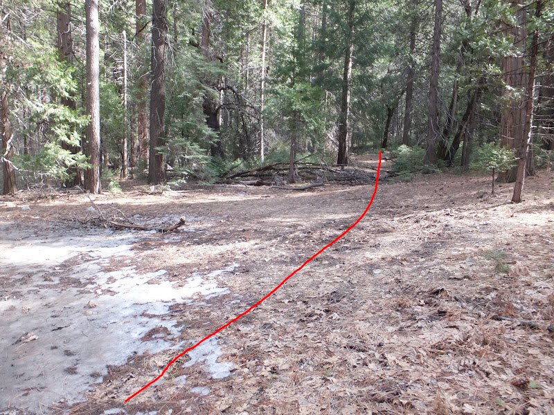
Well, I checked it out again this old portion of the Wawona Road on Monday (from where it starts across from the modern Bridalveil Parking Lot entrance to where it intersects again with the modern Wawona Road. It's still in surprisingly good shape (probably because AT&T cables are buried beneath it).
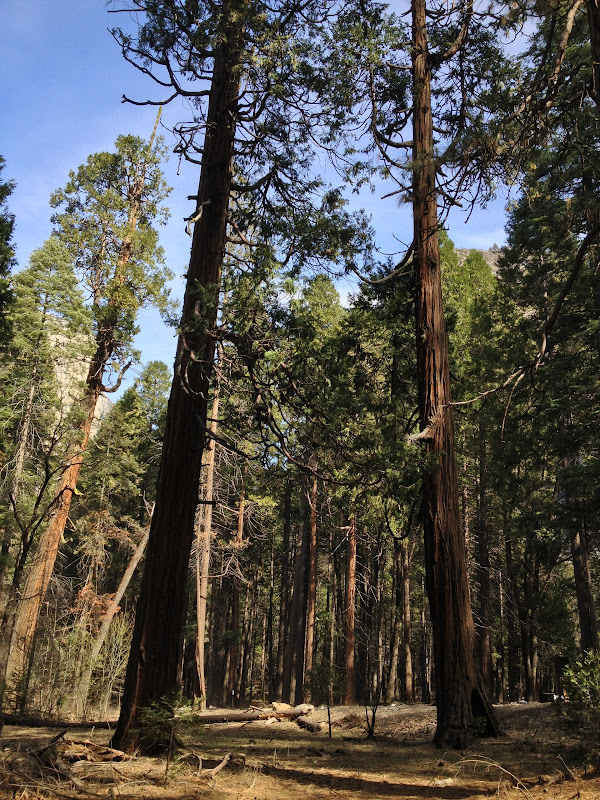
If you know where to look, the beginning of the Wawona Road is actually easy to spot because the because the builders of the old Wawona wagon road decided way back then to mark the start of the Wawona Road, symbolically, with a pair of giants sequoias (which today are a bit sickly looking as giant sequoias go) with the old road going between the two trees.
Here's are several pictures of the giants sequoias that mark the beginning of the old Wawona wagon road on the valley floor:


And here's a video of the small segment of the Old Wawona Road:
Edited 1 time(s). Last edit at 02/20/2013 08:26AM by plawrence.
February 20, 2013 06:47AM | Moderator Registered: 14 years ago Posts: 7,421 |
February 20, 2013 09:33AM | Registered: 15 years ago Posts: 4,173 |

February 20, 2013 09:44PM | Moderator Registered: 14 years ago Posts: 7,421 |
To be more certain... or just confuse yourself more....
if you have a Garmin that can take custom maps...
you can create a KMZ and stuff it in your Garmin and
precisely walk the old road...
Here's a screen shot of walking that section along with
an old map put into Garmin.... note that the old Yose Valley
maps are extremely accurate.

this is what the track looks on a modern map:

Of course I've already created a KMZ so if you really want it... and
don't want to do the work yourself... its free today if you ask for it.

Have fun
if you have a Garmin that can take custom maps...
you can create a KMZ and stuff it in your Garmin and
precisely walk the old road...
Here's a screen shot of walking that section along with
an old map put into Garmin.... note that the old Yose Valley
maps are extremely accurate.
this is what the track looks on a modern map:
Of course I've already created a KMZ so if you really want it... and
don't want to do the work yourself... its free today if you ask for it.
Have fun
March 18, 2013 05:56PM | Moderator Registered: 14 years ago Posts: 7,421 |
Quote
plawrence
If you know where to look, the beginning of the Wawona Road is actually easy to spot because the because the builders of the old Wawona wagon road decided way back then to mark the start of the Wawona Road, symbolically, with a pair of giants sequoias (which today are a bit sickly looking as giant sequoias go) with the old road going between the two trees.
Do you have a link? Because took a look ... twice actually... and boy, they sure just look like Incense Cedars.
March 19, 2013 01:25AM | Registered: 15 years ago Posts: 4,173 |
Quote
chick-on
Quote
plawrence
If you know where to look, the beginning of the Wawona Road is actually easy to spot because the because the builders of the old Wawona wagon road decided way back then to mark the start of the Wawona Road, symbolically, with a pair of giants sequoias (which today are a bit sickly looking as giant sequoias go) with the old road going between the two trees.
Do you have a link? Because took a look ... twice actually... and boy, they sure just look like Incense Cedars.
When I looked at those trees, to my eyes both the bark, the needles, the branch structure, and the shape of the crowns appeared to look more like sequoias than incense cedars. There are a number of incense cedars in that general area, including one, IIRC, very near those two trees, that look a bit different (including looking far more healthier) than those two rather sickly trees. Incense cedars thrive on the valley floor and those two trees are not thriving at all. (And the old road definitely went between those two trees.)
But I've been mistaken before. It wouldn't be the first time. I'll take another look at them myself the next time I'm in Yosemite and even get a good whiff of the bark to see if it has the telltale scent of an incense cedar.
Edited 1 time(s). Last edit at 03/19/2013 01:26AM by plawrence.
March 20, 2013 07:11AM | Moderator Registered: 14 years ago Posts: 7,421 |
Yeah, I just don't know. Couldn't convince myself they were Sequoias.
Where's that basil bird when I need him?
Here's a photosynth of the trees:
http://photosynth.net/view.aspx?cid=8d4c312a-0da3-4842-ae24-0240f16f9afc
And here's some comparison:
Sequoia next to The Museum (near the trunk section) (south side) :

Incense Cedar near Museum (Indian Village) :

One of trees in question:

looking up:

So... you may be right. It's just that all 3 of these trees are about the same size.
The pictures sure make it look so. Just dunno for sure.
Take a look again... and someone else too.
Where's that basil bird when I need him?
Here's a photosynth of the trees:
http://photosynth.net/view.aspx?cid=8d4c312a-0da3-4842-ae24-0240f16f9afc
And here's some comparison:
Sequoia next to The Museum (near the trunk section) (south side) :
Incense Cedar near Museum (Indian Village) :
One of trees in question:
looking up:
So... you may be right. It's just that all 3 of these trees are about the same size.
The pictures sure make it look so. Just dunno for sure.
Take a look again... and someone else too.
|
Re: Older roads superimposed on newer roads March 20, 2013 07:20AM | Registered: 13 years ago Posts: 864 |
March 20, 2013 07:31AM | Moderator Registered: 14 years ago Posts: 7,421 |
Nope. The ground around there is pretty clean. Looked around a bit... couldn't find anything.
On a related note... also got completely confused (a somewhat ongoing theme) on the Mirror
Lake loop. The leaves on the trees there... boy... I can't tell any difference b/t Incense and Sequioa.
Gave up quickly there trying to find anything looking like a Sequioa.
On a related note... also got completely confused (a somewhat ongoing theme) on the Mirror
Lake loop. The leaves on the trees there... boy... I can't tell any difference b/t Incense and Sequioa.
Gave up quickly there trying to find anything looking like a Sequioa.
March 24, 2013 03:04AM | Registered: 15 years ago Posts: 4,173 |
Went back there on Saturday. With the help of binoculars, I have to admit that the foliage of those two trees appear to be closer to that of the incense cedar (and not the giant sequoia as I originally thought). So the Chick-on is correct, they're probably incense cedars (though the bark does not have any sort of strong incense cedar scent to it). It also puzzles me why those two incense cedars are so sickly looking, especially compared to the more robust looking incense cedars that are just to the west of the pair.
One other reason why I originally thought they were giant sequoias is because the one closest to the road has a good size fire scar on the bottom of its base. I didn't think incense cedars could survive with such a deep fire scar.
Edited 1 time(s). Last edit at 03/24/2013 10:07PM by plawrence.
One other reason why I originally thought they were giant sequoias is because the one closest to the road has a good size fire scar on the bottom of its base. I didn't think incense cedars could survive with such a deep fire scar.
Edited 1 time(s). Last edit at 03/24/2013 10:07PM by plawrence.
March 25, 2013 07:15AM | Moderator Registered: 14 years ago Posts: 7,421 |
I understand. Believe me... I was hoping... but just couldn't fit the square peg in.
Went back myself Sat and Sunday... and with the clue of basilblop...
Sequioa next to an Incense:

Three(!) Sequioas right near Sentinel Bridge:

One of dem:
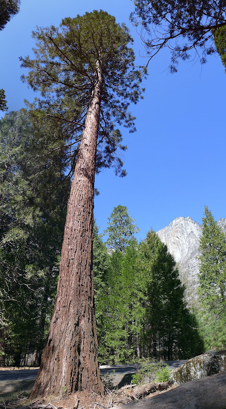
And.... the two sickly Incense Cedars in question: (def. not Sequioa's)

Thanks Peter
(and I'll just add... it doesn't matter if you're wrong or right... as long as in the end we get it Half Dome Right)
(or 80% Dome Left)
Went back myself Sat and Sunday... and with the clue of basilblop...
Sequioa next to an Incense:
Three(!) Sequioas right near Sentinel Bridge:
One of dem:
And.... the two sickly Incense Cedars in question: (def. not Sequioa's)
Thanks Peter
(and I'll just add... it doesn't matter if you're wrong or right... as long as in the end we get it Half Dome Right)
(or 80% Dome Left)
March 25, 2013 08:46AM | Registered: 15 years ago Posts: 4,173 |
Thanks for the photos of the ones located at the Old Yosemite Village site by Sentinel Bridge. I was by there last Saturday too but didn't take any photos of those sequoias.
I was using as comparison the one that was marked in front of the Yosemite Museum (I think you posted a photo of it above).
(There are several more sequioas located in the Yosemite Cemetery too.)
I was using as comparison the one that was marked in front of the Yosemite Museum (I think you posted a photo of it above).
(There are several more sequioas located in the Yosemite Cemetery too.)
|
Re: Older roads superimposed on newer roads March 25, 2013 01:53PM | Registered: 13 years ago Posts: 864 |
I also agree--the ones on the old Wawona road segment are incense cedars. (On the other hand, I believe there is a sequoia at the other end of the current Wawona road, between the entrance and comfort stations...)
As for the real sequoias near Sentinel Bridge, I remember reading that there used to be a small metal fence around one of them... probably long gone.
As for the real sequoias near Sentinel Bridge, I remember reading that there used to be a small metal fence around one of them... probably long gone.
|
Re: Older roads superimposed on newer roads March 25, 2013 11:59AM | Registered: 12 years ago Posts: 1,976 |
Hopefully I can explain this clearly. If you look at the foliage of a cedar tree, they are in sections that look like a fan and the needles are in a flat plane and they are usually a brighter green. Sequoia foliage flairs out more from the branches/stems and their needles are very prickly looking and do not lie flat against each other. The bark of a large sequoia is usually more spongy looking than a cedars.
The cedars in Yosemite are Incense Cedar and interesting enough are used to make pencils and they don't have much fragrance. The cedar species that is fragrant and is used for closets and such is the Spanish Cedar.
The cedars in Yosemite are Incense Cedar and interesting enough are used to make pencils and they don't have much fragrance. The cedar species that is fragrant and is used for closets and such is the Spanish Cedar.
March 25, 2013 01:36PM | Moderator Registered: 14 years ago Posts: 7,421 |


October 24, 2011 07:39AM | Registered: 14 years ago Posts: 7,421 |

October 22, 2012 11:42AM | Registered: 15 years ago Posts: 4,173 |
|
Re: Older roads superimposed on newer roads October 22, 2012 12:58PM | Registered: 14 years ago Posts: 755 |
Quote
chick-on
Here's Old Tioga drawn on a Park Map.
I could be wrong drawing it off the current road by Porc. Pine Flat though.
The rest is right. It used to go by Soda Springs/Parsons.
Here's his map at a more legible scale. Use the magnifier symbol, if your browser shrinks it to fit on the page....
https://lh5.googleusercontent.com/-n3702roGJik/TqV3YQdKG8I/AAAAAAAAUE4/P9DjK8O6Ij4/s1600/OldTioga.jpg
I agree, it looks right. Note that a lot of the road east of Porcupine Flat has become part of the trail system.
|
Re: Older roads superimposed on newer roads October 22, 2012 02:41PM | Registered: 12 years ago Posts: 45 |
We have had some discussion on the old Tioga Road on the Carlon thread:
http://yosemitenews.info/forum/read.php?3,58064,60460#msg-60460
Toward the bottom of that thread, I've pointed out some corrections to this map; particularly that the Old Tioga Road largely follows a different alignment than the current road from Tuolumne Meadows to Tioga Pass, unlike what is shown on this map. I'm not good with drawing on digital maps, but could provide all of the details as I know them to someone who can do such a drawing.
October 23, 2012 07:31AM | Moderator Registered: 14 years ago Posts: 7,421 |
That was my intention. For you to see this and comment. Pretty much you said what
I thought you would. Someday I will follow your directions going from, more or less,
Tenaya Lake area to Tioga Pass with GPS in hand and get a nice track.
The closedcountour guy has sections of the road in his map.
May / Tenaya Lake area:
http://www.closedcontour.com/?zoom=7&lat=37.82571&lon=-119.4839&layers=B
Porcupine / Yose Creek area:
http://www.closedcontour.com/?zoom=7&lat=37.81752&lon=-119.55471&layers=B
Tuolumne Meadows area:
http://www.closedcontour.com/?zoom=7&lat=37.87904&lon=-119.32874&layers=B
Old Dude and I did a double take when hiking the old road near Gaylor stream area:
October 23, 2012 07:47AM | Moderator Registered: 14 years ago Posts: 7,421 |
Also, Rob, you may be interested in this:
http://yosemitenews.info/forum/read.php?3,27002,27002#msg-27002
This gist of it was simply... the sign was still there with mileage but the trail
has been more or less obliterated. Still need to go and try following it from
Tioga down. Why park service still has the old signs with the trail on them up
is a mystery to me. As I mentioned in that thread though... it helped me
out convincing the wife to just hike back up to the car at mono mdw th.
Also, in that thread is a link to the 1948 yose map:
http://gisserver.princeton.edu:81/navigatorMapViewer.htm?map=912
But even better is the 1928 map:
http://gisserver.princeton.edu:81/navigatorMapViewer.htm?map=916
or 1920:
http://gisserver.princeton.edu:81/navigatorMapViewer.htm?map=923
|
Re: Older roads superimposed on newer roads October 23, 2012 11:10AM | Registered: 12 years ago Posts: 45 |
October 23, 2012 01:10PM | Moderator Registered: 14 years ago Posts: 7,421 |
October 23, 2012 02:42PM | Registered: 12 years ago Posts: 578 |
December 24, 2012 07:32AM | Moderator Registered: 14 years ago Posts: 7,421 |

December 24, 2012 12:45PM | Admin Registered: 15 years ago Posts: 17,050 |
December 24, 2012 07:45PM | Registered: 15 years ago Posts: 4,173 |
December 25, 2012 07:24AM | Moderator Registered: 15 years ago Posts: 1,876 |
October 28, 2013 07:10AM | Moderator Registered: 14 years ago Posts: 7,421 |

|
Re: Older roads superimposed on newer roads May 31, 2014 01:20AM | Registered: 9 years ago Posts: 1 |
Regarding the old and new Tioga Road routes: Decades ago I researched some old Sierra Club Bulletins -- Bulletins from when several important Club members, including Ansel Adams, were protesting the modernizing of the road as a speedy highway. The streamlining of the Old Tioga Road, it was said, required the new road to pass through an area north of Polly Dome that was still unspoiled wilderness. I would like to see a more detailed map of just the part from where the road encounters Tenaya Lake up to the area around the pass where it enters the Tuolumne drainage, showing what changes were done there to turn the old road into a highway.
There is a sad story associated with this that is largely forgotten today. The widening of the old road to construct the current highway, in an act of great geological sacrilege, blasted through one of the finest examples of glacial polish in the world. The pass that contains Tenaya Lake is the route where the biggest stream of ice from Tuolumne Basin's Mer de Glace overflowed into the Merced drainage. Over this unjointed and particularly hard silicious granite, glacial ice, 2,400 feet deep and over two miles wide, had ground the granite to a mirror sheen,where the polish remained unweathered and uneroded due to its altitude and exposure. This geological artifact was especially significant to the story of Yosemite Valley's creation, since one of the primary reasons for Yosemite's extraordinary grandeur is that the Valley received far more ice than was produced within just the Merced drainage. While the original river canyon of Yosemite was carved entirely by Merced River Basin waters, the later glacial valley that we know today was carved by the combination of both Merced Glacier ice and Tuolumne ice that spilled over the Cathedral Range at several passes. The largest of these tongues of extra ice came through Tenaya Pass, making Tenaya Canyon far grander in scale than it should have been due to its small drainage area. All of that extra ice contributed to making the main Yosemite Valley bigger as well. John Muir was the first one to realize this fact. The best place to see this with the time-traveling eyes of a geologist is from the summit of the Cockscomb above the Echo Peaks, one of the best viewpoints in the park. On both sides of this cluster of peaks the mountains have been smoothed by flowing ice, but the Cockscomb, Echo Peaks, and Matthes Crest remained above the surface. A great deal of ice also flowed into the Upper Merced Valley over the divide between Cockscomb and Vogelsang, but it was shallower and slower-moving than the ice going through Tenaya Pass. Geologists know that bare and smooth granite surfaces do not weather much at all because water runs off quickly and the surfaces dry fast in the sunlight. The glacial polish beside Tenaya Lake on its northwest side was unusual in that it was created at the base of a very large glacier, but once the glacier was gone, the polish was uncovered at the crest of a divide. Thus it is it both remarkably smooth, almost mirrorlike, from the great weight of the glacier, and it is exposed in a place where it could catch the morning sunlight and remain unweathered, lasting thousands of years undiminished in its splendor. It took human dynamite, sadly from the National Park Service itself, to destroy this precious geological relic in an instant, the feature that gave Tenaya Creek its original name -- Py-we-ack, the "river of glistening rocks."
To see a picture of some of what remains, go to: http://www.yosemite.ca.us/library/geologic_story_of_yosemite/images/55-b.jpg.
Two excellent maps of the ice sheets are at: http://www.nps.gov/history/history/online_books/geology/publications/pp/160/images and http://pubs.usgs.gov/imap/i1885/i1885.pdf.
Edited 1 time(s). Last edit at 05/31/2014 06:33AM by robertsturner52.
June 09, 2014 07:22AM | Moderator Registered: 14 years ago Posts: 7,421 |
robertsturner52,
Thank you for this post. Much appreciated. The Old Tioga Road from Tenaya Lake to Tuolumne Meadows
follows the trail... just south of the new road. If you hike this trail it will be evident.
What I personally don't know with certainty is if the old road went north or south of Tenaya Lake itself.
I've been told south but with the topography and all I question the validity of that.
As for glacial polish, Yosemite area has sooooo many examples... I hear you on the blasting...
if you simply follow Tenaya Creek a bit a ways down... you will come to an incredible example of
glacial polish and carving. There are many pictures on this site of that location. It's fairly easy to
get to off trail and a amazing location.
I don't know who is in charge but I just shake my head when I see granite blasted for seemingly
ridiculous reasons in the backcountry. Granite along a creek next to a dome... blasted... because
I guess it's not obvious that the trail goes between this dome and the river.
Anywho. Just wanted to say thanks for the post.
|
Re: Older roads superimposed on newer roads June 09, 2014 07:40PM | Registered: 13 years ago Posts: 617 |
Quote
chick-on
What I personally don't know with certainty is if the old road went north or south of Tenaya Lake itself.
I've been told south but with the topography and all I question the validity of that.
I've always wondered about the alignment here, as well. I don't ever recall hearing that it went south of the lake (and, as you say, it seems unlikely). I do seem to remember reading commentary that one of the reasons that the Sierra Club was opposed to the new alignment was that it came much to close to the Lake but, every old/new map overlay I've seen shows that the alignments were essentially the same along the north shore of the lake. Take a look at this, for example:

(Nicer TIFF image here but apparently, I can't embed a TIFF in these messages).
There's the obvious diversion at Olmstead Point where the old road went north of that dome and the new road cut through it but then it seems to share an alignment briefly before swinging south of the new alignment. This particular map doesn't make it clear exactly where the lake is in relation to the road but it looks like the swing-to-the-south is east of the lake (well, it's actually more of a swing-to-the-NE just NNE of the lake!). I've not hiked this middle stretch of the OTR yet so I've only got maps to go by.
June 09, 2014 07:41PM | Admin Registered: 15 years ago Posts: 17,050 |
|
Re: Older roads superimposed on newer roads June 09, 2014 10:05PM | Registered: 14 years ago Posts: 755 |

June 24, 2014 07:00AM | Moderator Registered: 14 years ago Posts: 7,421 |
Hiked from TM to Tenaya Lake with Z Old Guy last weekend.
Without question there are two sections of The Old Tioga Road...
One near FairView / Cathedral Creek crossing... The other right
at Pywiack Dome. Could not find any other remnants.. which
leads me to believe that the road followed the current alignment...
it's either that... or it was so woefully constructed that it has been
entirely obliterated. Even though the trail on the maps looks
plausible (the actual trail has been moved higher) as the old road...
personally was unable to find anything resembling a road..
and ... that really says alot in my book since these old roads
are blatantly obvious when you see them.
Anywho.... the maps:

Red = Old Tioga Road
Black = Road from very crude 1929 map (I do not believe this alignment on current map) (BM are too far off)
This is a 1956 map... mainly b/c I love the old pullouts... which need to explore
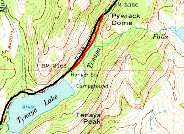
The Pywiack section you can hike all the way down to Tenaya Lake parking lot (or vice-versa ... or both-a-versa)
Enjoy
Without question there are two sections of The Old Tioga Road...
One near FairView / Cathedral Creek crossing... The other right
at Pywiack Dome. Could not find any other remnants.. which
leads me to believe that the road followed the current alignment...
it's either that... or it was so woefully constructed that it has been
entirely obliterated. Even though the trail on the maps looks
plausible (the actual trail has been moved higher) as the old road...
personally was unable to find anything resembling a road..
and ... that really says alot in my book since these old roads
are blatantly obvious when you see them.
Anywho.... the maps:
Red = Old Tioga Road
Black = Road from very crude 1929 map (I do not believe this alignment on current map) (BM are too far off)
This is a 1956 map... mainly b/c I love the old pullouts... which need to explore
The Pywiack section you can hike all the way down to Tenaya Lake parking lot (or vice-versa ... or both-a-versa)
Enjoy
|
Re: Older roads superimposed on newer roads October 22, 2012 01:12PM | Registered: 13 years ago Posts: 1,697 |
Sorry, only registered users may post in this forum.

