http://www.usgs.gov/newsroom/article.asp?ID=3024
As usual, I couldn't paste the article so hope the link works...

The Moon is Waxing Gibbous (72% of Full)
Re: USGS maps become available
All posts are those of the individual authors and the owner
of this site does not endorse them. Content should be considered opinion
and not fact until verified independently.
|
USGS maps become available November 08, 2011 10:13AM | Registered: 13 years ago Posts: 693 |
November 08, 2011 01:13PM | Admin Registered: 15 years ago Posts: 17,051 |
Nearly 124,000 high resolution scans of the more than 200,000 historical USGS topographic maps, some dating as far back as 1884, are now available online. The Historical Topographic Map Collection includes published U.S. maps of all scales and editions, and are offered as a georeferenced digital download or as a scanned print from the USGS Store.
"These maps harken back to California's past, when its awesome topography could make a simple trip for staples a day-long journey in a horse-drawn buckboard," said USGS director Marcia McNutt. "The uses of these maps for scientists, historians, educators, and even by those who simply want to be reminded of a time when life moved a little slower, are limited only by our imagination."
Historical maps are an important national resource as they provide the long-term record and documentation of the natural, physical and cultural landscape. The history documented by this collection and the analysis of distribution and spatial patterns is invaluable throughout the sciences and non-science disciplines. Genealogists, historians, anthropologists, archeologists and others use this collection for research as well as for a framework on which a myriad of information can be presented in relation to the landscape. For more than 130 years, the USGS topographic mapping program has accurately portrayed the complex geography of our nation through maps using the lithographic printing process. The historical collection contains high resolution scanned images from the USGS legacy series and other sources and was made public mid-September, 2011.
Historical maps are offered to the public at no cost in GeoPDF format or as a printed copy for $15 plus a $5 handling charge from the USGS Store and can be used in conjunction with the new USGS digital topographic map, the US Topo. Check the website for continuous updates.
The project is part of the USGS National Geospatial Program (NGP) continuing efforts to support the mapping and location-based data needs of the Nation.
November 08, 2011 03:38PM | Registered: 13 years ago Posts: 424 |
November 08, 2011 07:45PM | Registered: 13 years ago Posts: 1,351 |
Thanks for the link.
I checked the Vogelsang area, at both the 7.5/15 minute and larger scales, and they don't yet have the maps Chick-On posted, the oldest dated from 1947. I did find a 1899 15 minute map of where I live, so that was pretty cool.
(Edit: plawrence, I saw your post in another thread, and they do seem to have some old maps of the valley. At the 30 minute scale back to 1897)
Edited 1 time(s). Last edit at 11/08/2011 07:51PM by ttilley.
November 08, 2011 10:00PM | Moderator Registered: 15 years ago Posts: 1,918 |
Yeah, kinda a bummer they don't have the ones Princeton have.
Those are some of the best maps I have seen. Love those.
Regardless, awesome USGS is doing this. Some really great old maps with old trails.
Of course you can search for "Yosemite". But for reference... here are the Quads for Yosemite:

The adjoining map is typically marked on the map. They do vary it seems depending on year and/or size.
(one I can think of is simply "Tuolumne Meadows" )
Here's the link to Old Topos that includes links to Berkeley and Princeton:
http://yosemitenews.info/forum/read.php?1,5185
 to HikerChick395 for finding this
Those are some of the best maps I have seen. Love those.
Regardless, awesome USGS is doing this. Some really great old maps with old trails.
Of course you can search for "Yosemite". But for reference... here are the Quads for Yosemite:
The adjoining map is typically marked on the map. They do vary it seems depending on year and/or size.
(one I can think of is simply "Tuolumne Meadows" )
Here's the link to Old Topos that includes links to Berkeley and Princeton:
http://yosemitenews.info/forum/read.php?1,5185
to HikerChick395 for finding this|
Re: USGS maps become available November 09, 2011 08:02AM | Registered: 13 years ago Posts: 693 |
November 09, 2011 12:32PM | Moderator Registered: 15 years ago Posts: 1,918 |
November 09, 2011 01:48PM | Admin Registered: 15 years ago Posts: 17,051 |
November 09, 2011 02:03PM | Registered: 15 years ago Posts: 4,173 |
Quote
bill-e-g
Downloaded a zillion of them already. Thanks again. Purty much I seldom look at Topix mainly due to
after posting something over there pretty much I was told I don't do real backpacking.
Okay, I took time to read that thread over there. Pretty funny and pretentious comment by the "Founding Member" of High Sierra Topix.

Edited 3 time(s). Last edit at 11/09/2011 05:44PM by plawrence.
November 10, 2011 08:57AM | Moderator Registered: 15 years ago Posts: 1,918 |

|
Re: USGS maps become available November 09, 2011 02:04PM | Registered: 15 years ago Posts: 619 |
November 09, 2011 05:42PM | Registered: 15 years ago Posts: 2,321 |
|
Re: USGS maps become available November 10, 2011 08:24AM | Registered: 13 years ago Posts: 693 |
Quote
bill-e-g
Downloaded a zillion of them already. Thanks again. Purty much I seldom look at Topix mainly due to
after posting something over there pretty much I was told I don't do real backpacking.
Yeah, I'm a real slacker compared to some of their standards. Yet, I won a little photo contest held there with a photo of North Lake. (I did get a snide remark from someone on Topix' faceybook site that that location was close to a road...hey, the people voted...)
I do enjoy reading their trip reports and photos, though. There is a lot of criticism over there. That's why I enjoy the positive and fun attitude of these forums and I have learned so much about places I thought I really knew. LOVE photos and trip reports here, too...just wish I could share my photos easier.
November 10, 2011 09:06AM | Moderator Registered: 15 years ago Posts: 1,918 |
Picasa! Picasa!
Picasa is IMHO the best site for sharing pix. You can easily open a new gmail account
and then upload photos to picasa. If for some reason you need to be 'invited' then just
PM me w/your email adx and I'll do that. Please share pix. Too many do not imo.
I seriously get a little frustrated ... I like sharing and showing.. wish others would more.
As for what you do and whatnut. Honestly I'm not into the pissing contests. If you
wanna hike for 300 days a year. go crazy. I know we got it good... and I'm able to
pursue my passion. It's fun to share that. Getting a little ribbing has always been fun.
Getting people jealous or getting flamed isn't the goal. I personally have a lot of
goals which keeps me going back for more and exploring more and more.
It keeps it fun. I hope I don't offend too often. That's certainly not the goal.
Anywho. Have a nice day. I'll be in the mountains (even if I'm in a cube)
|
Re: USGS maps become available November 12, 2011 12:47AM | Registered: 14 years ago Posts: 755 |
Bill-e-g has mentioned this before, but it you are interested in older Yosemite maps, there are a few on the David Rumsey historical map site that are of interest. I was reminded of this again on Thursday, when I had a couple of hours to kill in San Francisco, and went up to the history room in the Main Library. I saw a map there that was very interesting with respect to the recent threads on the Old Big Oak Flat Road and on the Mariposa Trail that first brought white men into the park. See link:link
This map was issued by the California Geological Survey in three editions. I believe that the copy I saw was the second edition, circa 1870, since Gentry's Station on the Big Flat Trail was labeled by name. The Old Big Oak Flat Road had not been finished yet, so the trail shown from there to the valley floor is the old horse trail. When I asked about making a photocopy, the attendant suggested coming back with my own camera, but said that the same map is on the Rumsey site. Sure enough, it is, though that one is the the 1867 version. See link: link
One nice thing about this link is that you can blow the thing up by an enormous amount in your browser. Or with some effort, you can download a compressed jpeg of 11,728 by 7842 pixels. This allows you to select any piece that you want with good resolution. For example, here is a small section of relevance to the recent threads on the Hill Painting (link) and on the old Big Oak Flat horse trail (link)

In the picture above, "1" indicates where the Mariposa Trail crosses what I call 1st Saddle in the cited link, then it follows Meadow Brook to Mt Beatitude at "2". Gentry's station is at "3".
The other interesting historical map at the Rumsey is the the USGS Yosemite map of 1893. See link: link Both of these maps show the coffin-shaped outline of the Yosemite Grant, but this one has it clearly delineated in red. What is special about this map is that there is also an 1883 version (link) that he has overlaid onto Google Earth. Then by moving the overlay opacity slider back and forth, you can switch between the old map and the aerial view. What you do is go to this page link and then click on "Launch Google Earth Application" (assuming that you already have Google Earth on your computer). The resulting view of the earth has little flags where he has put overlays. Zoom in on Yosemite, and you have it.
For example, here is the whole map:
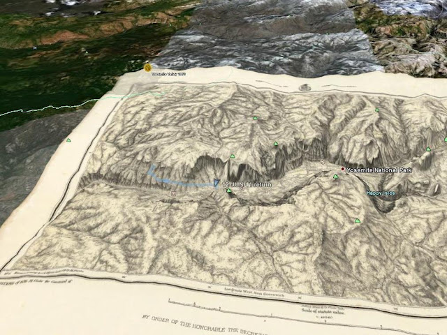
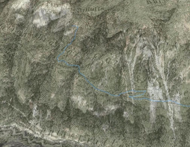
I have added the return gps track from my hike to the top of Falls at Fireplace Creek (link).
into Google Earth, so it shows as a faint blue trace, with a flag at the start. You can then see the map in a 3D view, with a faint blue gps track:

Or see the earth:
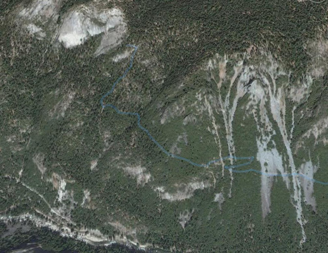
Or by playing with the overlay opacity slider, you can see a ghostly mixture of the two:
Looking in the other direction, you can see how this old map has Mt Beatitude and Old Inspiration Point interchanged from what everyone else says. But that's a subject for a post elsewhere; this one is already too long.
Edited 1 time(s). Last edit at 11/12/2011 12:54AM by wherever.
This map was issued by the California Geological Survey in three editions. I believe that the copy I saw was the second edition, circa 1870, since Gentry's Station on the Big Flat Trail was labeled by name. The Old Big Oak Flat Road had not been finished yet, so the trail shown from there to the valley floor is the old horse trail. When I asked about making a photocopy, the attendant suggested coming back with my own camera, but said that the same map is on the Rumsey site. Sure enough, it is, though that one is the the 1867 version. See link: link
One nice thing about this link is that you can blow the thing up by an enormous amount in your browser. Or with some effort, you can download a compressed jpeg of 11,728 by 7842 pixels. This allows you to select any piece that you want with good resolution. For example, here is a small section of relevance to the recent threads on the Hill Painting (link) and on the old Big Oak Flat horse trail (link)
In the picture above, "1" indicates where the Mariposa Trail crosses what I call 1st Saddle in the cited link, then it follows Meadow Brook to Mt Beatitude at "2". Gentry's station is at "3".
The other interesting historical map at the Rumsey is the the USGS Yosemite map of 1893. See link: link Both of these maps show the coffin-shaped outline of the Yosemite Grant, but this one has it clearly delineated in red. What is special about this map is that there is also an 1883 version (link) that he has overlaid onto Google Earth. Then by moving the overlay opacity slider back and forth, you can switch between the old map and the aerial view. What you do is go to this page link and then click on "Launch Google Earth Application" (assuming that you already have Google Earth on your computer). The resulting view of the earth has little flags where he has put overlays. Zoom in on Yosemite, and you have it.
For example, here is the whole map:
I have added the return gps track from my hike to the top of Falls at Fireplace Creek (link).
into Google Earth, so it shows as a faint blue trace, with a flag at the start. You can then see the map in a 3D view, with a faint blue gps track:
Or see the earth:
Or by playing with the overlay opacity slider, you can see a ghostly mixture of the two:
Looking in the other direction, you can see how this old map has Mt Beatitude and Old Inspiration Point interchanged from what everyone else says. But that's a subject for a post elsewhere; this one is already too long.
Edited 1 time(s). Last edit at 11/12/2011 12:54AM by wherever.
November 13, 2011 05:52PM | Moderator Registered: 15 years ago Posts: 1,918 |

Sorry, only registered users may post in this forum.

