Is 120 closed for the season? The cal trans website says "closed due to snow" but not "closed for the winter". Does anyone have any info on whether or not it will reopen in 2011?
Does anyone know how much snow is up on Gin flat or up along the snow creek trail? Would either place be good for snow shoeing? We have a long weekend coming up and are itchin' to get out.
Thanks for any help.

The Moon is Waxing Gibbous (75% of Full)
Re: Road Closures and snow questions
All posts are those of the individual authors and the owner
of this site does not endorse them. Content should be considered opinion
and not fact until verified independently.
|
Road Closures and snow questions November 10, 2011 07:02AM | Registered: 12 years ago Posts: 44 |
November 10, 2011 07:29AM | Registered: 15 years ago Posts: 2,321 |
Quote
riverkat
Is 120 closed for the season? The cal trans website says "closed due to snow" but not "closed for the winter". Does anyone have any info on whether or not it will reopen in 2011?
Does anyone know how much snow is up on Gin flat or up along the snow creek trail? Would either place be good for snow shoeing? We have a long weekend coming up and are itchin' to get out.
Thanks for any help.
The NPS will usually try to get 120 open but will close it for the season if keeping it plowed is futile. A lot of early snowfalls melt off pretty quickly but this batch of storms seems to keep coming so it might not reopen. There is no overnight parking on 120 after October 15th so even if 120 is open you can only dayhike off it.
The Snow Creek trail from the valley is usually snow free with no snow until the rim. Lug your shoes and use them if needed.
Old Dude
Edited 1 time(s). Last edit at 11/10/2011 07:29AM by mrcondron.
November 10, 2011 09:14AM | Moderator Registered: 15 years ago Posts: 1,918 |
I doubt there is really many places in Yosemite where the snow shoeing would be decent.
IMO you need a good couple feet of snow to make it worth the added effort. Less than
that and it's just added weights on your feet... (i.e. just post hole thru the snow if it's that little)
Even if there is snow on the Snow Creek trail ppl will typically just walk up it w/o snowshoes.
(in the same fashion as Yose Falls trail)
ala as in picture #18 here:
https://picasaweb.google.com/yosemite.chick.on/SnowCreek
Have fun... we'll be there too this weekend
|
Re: Road Closures and snow questions November 11, 2011 08:27AM | Registered: 12 years ago Posts: 44 |
I have read acouple of things about the snow creek trail.... and am wondering if you folks have any information on the following..
I read that later in winter there are some avalanch zones along this trail..... does any one have any references as to where they are? Does the NPS post anything on the trail, in print or on the web where I can reference avalanche information?
How long is the trail from the valley to Tioga Pass rd?
How far the cabin from the mirror lake trailhead?
Thanks in advance for any assistance....
|
Re: Road Closures and snow questions November 11, 2011 02:40PM | Registered: 13 years ago Posts: 931 |
Quote
riverkat
I have read acouple of things about the snow creek trail.... and am wondering if you folks have any information on the following..
I read that later in winter there are some avalanch zones along this trail..... does any one have any references as to where they are? Does the NPS post anything on the trail, in print or on the web where I can reference avalanche information?
How long is the trail from the valley to Tioga Pass rd?
How far the cabin from the mirror lake trailhead?
Thanks in advance for any assistance....
Never been on the trail during cold season. From the valley to Tioga, whichever route you take, is minimum 12 miles. The cabin is ~7800 feet, near Watkins.
November 12, 2011 08:44AM | Registered: 15 years ago Posts: 2,321 |
Quote
Ohnivy-Drak
Quote
riverkat
I have read acouple of things about the snow creek trail.... and am wondering if you folks have any information on the following..
I read that later in winter there are some avalanch zones along this trail..... does any one have any references as to where they are? Does the NPS post anything on the trail, in print or on the web where I can reference avalanche information?
How long is the trail from the valley to Tioga Pass rd?
How far the cabin from the mirror lake trailhead?
Thanks in advance for any assistance....
Never been on the trail during cold season. From the valley to Tioga, whichever route you take, is minimum 12 miles. The cabin is ~7800 feet, near Watkins.
From Mirror Lake to Olmstead Point it's closer to nine miles. You have to get back though.
Old Dude
|
Re: Road Closures and snow questions November 13, 2011 06:03PM | Registered: 14 years ago Posts: 755 |
Quote
riverkat
I read that later in winter there are some avalanche zones along this trail..... does any one have any references as to where they are?
I think that what you have read about is info from people who are using the Snow Creek Trail to get to the bunk cabin at Tulomne Meadows. There are serious avalanche zones around Olmstead Point. Don't try going in that area without some more detailed information. But I am not aware of any problems until you get well past Mt. Watkins. I have camped at the Mt. Watkins saddle, and can recommend it. There is also good camping before and after the bridge that the trail takes over Snow Creek, after you reach the valley rim. Be aware that it is a lot of work to do all that uphill. The 106 switchbacks are not well suited for skis, if they happen to be snow covered, and the postholing can be very tiring. If the snow has an icy crust, the switchbacks can also be likely to give you a broken ankle, since there are stone steps and things underneath.
The best thing about this route is that you can just turn around if it gets to be too much. There are plenty of other things worth doing instead.
November 13, 2011 05:34PM | Moderator Registered: 15 years ago Posts: 1,918 |
Where did you read that? There are not av. spots on the trail to speak of really. I think maybe you are getting some bad info?Quote
riverkat
I have read acouple of things about the snow creek trail.... and am wondering if you folks have any information on the following..
I read that later in winter there are some avalanch zones along this trail..... does any one have any references as to where they are? Does the NPS post anything on the trail, in print or on the web where I can reference avalanche information?
Of course melting snow above does fall down... so maybe you read something like that and made conclusions
or people are making it worse than what it is.
At least that is my take on it. Been up it many times. Conditions vary of course. But even when talking to a ranger at the
top ... he said he had to posthole all the way to the top... after a big dump... never a mention of Avs.
To Tioga Pass rd. is approx 9.5 miles. The spot you want to get onto the road is the Snow Creek trail jct. up on Tioga.Quote
riverkat
How long is the trail from the valley to Tioga Pass rd?
If you think you are going to go directly via the trail that drops down from Watkins area... uh.. think again
(been there... done that... but never again!)
You can either follow the ski trail all the way to the road... or if you able to follow the western trail you can go thataway
up to that same jct. (done both).
Mirror Lake Trailhead? That would be Happy Isles TH Parking area..Quote
riverkat
How far the cabin from the mirror lake trailhead?
From there it is approx. 7 miles. via the ski trail... but if you haven't done it before... you're gonna be
surprised how far it is before you REALLY start going up...
November 13, 2011 05:56PM | Admin Registered: 15 years ago Posts: 17,051 |
November 13, 2011 06:13PM | Moderator Registered: 15 years ago Posts: 1,918 |
Yeah.
If you look at this set. The map at the end-ish...
https://picasaweb.google.com/yosemite.chick.on/OlmstedPt
The track on the east... that was not the way to go...
The track coming back... that is the ski trail..
Ok. It's not the ski trail before and after the cabin... (south)..
I prefer to bust own trail at times. esp. fun coming down.
If you look at this set. The map at the end-ish...
https://picasaweb.google.com/yosemite.chick.on/OlmstedPt
The track on the east... that was not the way to go...
The track coming back... that is the ski trail..
Ok. It's not the ski trail before and after the cabin... (south)..
I prefer to bust own trail at times.
esp. fun coming down.|
Re: Road Closures and snow questions November 13, 2011 06:20PM | Registered: 12 years ago Posts: 44 |
Thanks for the info! We have every intention of staying on the trails and staying clear of trouble. This board is one of the best sources of info I have come across and I appreciate everyone's input. Ideally we can get up there before the snow gets too bad as we are not skiers - just hiker/backpacker types. We do look for trails that push us physically so we welcome the challenge of the steepness - that being said we are older and know that injuries both serious and mild can take a long time to heal. We appreciate every one's words of caution and will definitely heed them when we step forth.
You are so right about being able to turn around if it gets to be too much or it looks unsafe. Just hope we can explore part of the park from a new perspective. If you all have ideas for other winter hikes please do share.. I am already getting cabin fever. Running inside more than outside and rowing on a land rower instead of out on the water with my crew is boring. I need a little mountain fix and some cross training.
You are so right about being able to turn around if it gets to be too much or it looks unsafe. Just hope we can explore part of the park from a new perspective. If you all have ideas for other winter hikes please do share.. I am already getting cabin fever. Running inside more than outside and rowing on a land rower instead of out on the water with my crew is boring. I need a little mountain fix and some cross training.
November 13, 2011 11:02PM | Registered: 15 years ago Posts: 4,173 |
|
Re: Road Closures and snow questions November 14, 2011 06:33AM | Registered: 12 years ago Posts: 44 |
Quote
plawrence
Quote
riverkat
If you all have ideas for other winter hikes please do share.
As long as you don't mind hiking through the snow, the Pohono trail can be nice in winter, as can the El Capitan trail through Ribbon Meadow from the Big Oak Flat/Foresta Road Trailhead.
Snow just adds to the adventure and challenge - so long as things are not trecherous (like say doing Forester pass in a heavy snow year - I'm neither a smoker nor a drinker but after crossing that in mid june two years ago I could have used a shot and a smoke) and we are not in serious danger of falling. I will look those two trails up on the map this afternoon. Hooray! something new and exciting! Thanks!
November 14, 2011 07:13AM | Moderator Registered: 15 years ago Posts: 1,918 |
We can just list all the trails sans 4 Mile and that would be your answer.
However, not sure how much snow shoeing you have done or winter
travel. It's not winter calendar-wise yet... but as soon as the next big dump
comes in that throws down 4 feet of snow... then winter has arrived...
until that melts off. Travel on snow in winter is a completely different animal
than travel in June. Thru the whole year typically you can get up Yose Falls,
Snow Creek, and Nevada Fall w/o any extra equipment.
Beyond there you will prob. want some flotation device if you plan
on going a lot further. This will quickly become apparent if you attempt
otherwise.
From the 2 Peter mentioned:
El Cap - 10 miles. 3K+climb. If you can do that in a day in winter conditions... kudos
Pohono - If you want a winter experience... then just wait until Badger Pass opens
and go from there imo.
I'd put links to photos sets of both of these.. but I suspect people are getting sick of
me doing that. Not sure Peter has done the two he mentioned in winter... but
just a word to the wise... winter travel is easily 2x as hard as travel in summer.
And do not expect to follow any trail for some.
Sorry if I said a bunch of stuff you already know... but red flag came up with 'to El Cap'...
(also... don't even 100% count on being able to park at the Old Big Oak Flat TH
in winter) (they do not nec. always plow it)
Be Safe ... have fun
November 14, 2011 12:07PM | Registered: 15 years ago Posts: 4,173 |
Maybe I should clarify – I wasn't necessarily recommending both complete trails as a day hike, especially in winter with its short days (though smaller segments of each trail can be done as a day hike in winter), but more as relatively straightforward overnight backpacking trips, especially for just a winter weekend getaway.
Edited 1 time(s). Last edit at 11/14/2011 12:19PM by plawrence.
Edited 1 time(s). Last edit at 11/14/2011 12:19PM by plawrence.
November 14, 2011 12:27PM | Registered: 15 years ago Posts: 4,173 |
Quote
bill-e-g
Sorry if I said a bunch of stuff you already know... but red flag came up with 'to El Cap'...
Note that in my post I didn't state "to El Cap", but I'm just referring to the trail itself, which I always refer to as the El Capitan Trail. In winter, my usually destination on that trail is just to area around Ribbon Meadow.
November 14, 2011 01:58PM | Moderator Registered: 15 years ago Posts: 1,918 |
No worries. I was simply trying to provide a bit more information.
Even to Ribbon Meadow is 16 miles round trip. And that is a difficult 8 in winter if you are busting your own trail.
Not to mention the crossing of Wildcat, Tamarack, and Coyote which may give some much pause.
Even in April I've seen many not get past Tamarack.
That being said... in winter... with shovel in hand... any spot can be a nice camp spot.
Have fun
November 14, 2011 06:32PM | Registered: 15 years ago Posts: 2,321 |
November 14, 2011 08:17PM | Admin Registered: 15 years ago Posts: 17,051 |
Quote
mrcondron
Isn't there a picture or something having to do with crossing Tamarack?
You mean this one?
http://yosemitephotos.net/main.php/v/mrcondron/IMG_4296.JPG.html
November 14, 2011 09:56PM | Moderator Registered: 15 years ago Posts: 1,918 |
That picture was May 20th.
Here's the same spot in late April:
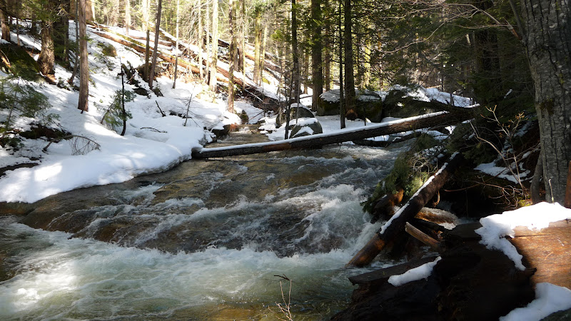
It's a non trivial crossing.
At this particular time I saw no one beyond Tam. Creek... and a bunch o peeps camped on the west side.
You can via Crane Flat / Tamarack CG... and avoid it... but that is one long haul...
Snow conditions vary greatly too and can play a huge part in how far you can go.
Sorry if I state the obvious.
Here's the same spot in late April:
It's a non trivial crossing.
At this particular time I saw no one beyond Tam. Creek... and a bunch o peeps camped on the west side.
You can via Crane Flat / Tamarack CG... and avoid it... but that is one long haul...
Snow conditions vary greatly too and can play a huge part in how far you can go.
Sorry if I state the obvious.
|
Re: Road Closures and snow questions November 15, 2011 08:59PM | Registered: 12 years ago Posts: 44 |
WOW! great pics of the same location.... had no idea that tamarak creek was like that.. Do not think I will attempt that crossing either. Being swept away by a raging torrent of water ranks right up there with falling off the side of forester pass.
Loved your second creek crossing Eek... made me laugh out loud.
I am thinking the Pohono trail might be fun for winter but I still hope to get up to that trail with tamarack creek sometime....
thanks everyone for all your great input.
Loved your second creek crossing Eek... made me laugh out loud.
I am thinking the Pohono trail might be fun for winter but I still hope to get up to that trail with tamarack creek sometime....
thanks everyone for all your great input.
November 14, 2011 08:33PM | Admin Registered: 15 years ago Posts: 17,051 |

November 15, 2011 11:48PM | Registered: 13 years ago Posts: 424 |
November 17, 2011 07:25AM | Moderator Registered: 15 years ago Posts: 1,918 |
You should hit the reply button so the conversation is in line.
(I think you do mostly though)
Anyway, just for the record.. those 2 pix were two different years..
although the transition is very valid. If you really look you'll see
there really isn't a huge amount of snow. And also... imo
the creek was fairly simple to get over... (there are many more logs
further upstream). YMMV (I've never falled in freezing water...
and I don't plan on it)
Sorry, only registered users may post in this forum.

