Welcome! Log In Create A New Profile Recent Posts
Tenaya Lake, Yosemite National Park

The Moon is Waxing Gibbous (55% of Full)


Advanced

Re: Indian Canyon

All posts are those of the individual authors and the owner of this site does not endorse them. Content should be considered opinion and not fact until verified independently.

Indian Canyon
November 27, 2011 09:19PM
wherever and chick-on have covered the Indian Canyon "trail" scramble already:

http://yosemitenews.info/forum/read.php?3,29137,29137#msg-29137

http://yosemitenews.info/forum/read.php?3,25265,26069#msg-26069

http://yosemitenews.info/forum/read.php?3,36903,36905#msg-36905

Indian Canyon is the canyon to the right (east) of Yosemite Falls when looking at the falls head-on; the mouth of it is near Church Bowl. James Hutchings paid to have a (toll) horse trail built up Indian Canyon in 1874, but it fell into disrepair only a few years later due to the difficulty of maintaining it. It didn't help that Conway had built the nearby more scenic trail to the top of Yosemite Falls around the same time.

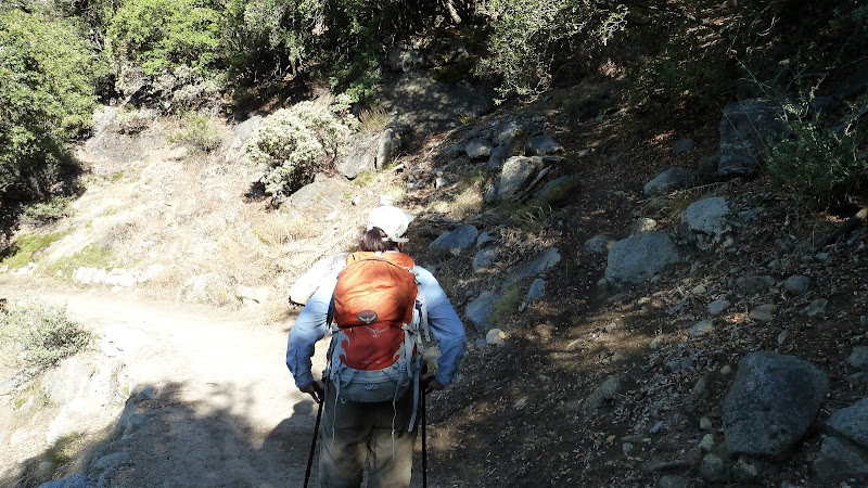
The "junction" with this trail and the portion of the valley loop trail between Lower Yosemite Falls and Church Bowl is roughly 100 yards east of an open talus field that is near the highest part of the trail in this section. When I was there it was marked by a few ducks, and in fact the lower several switchbacks were similarly ducked--probably because the trail is used as a climbers' access route.

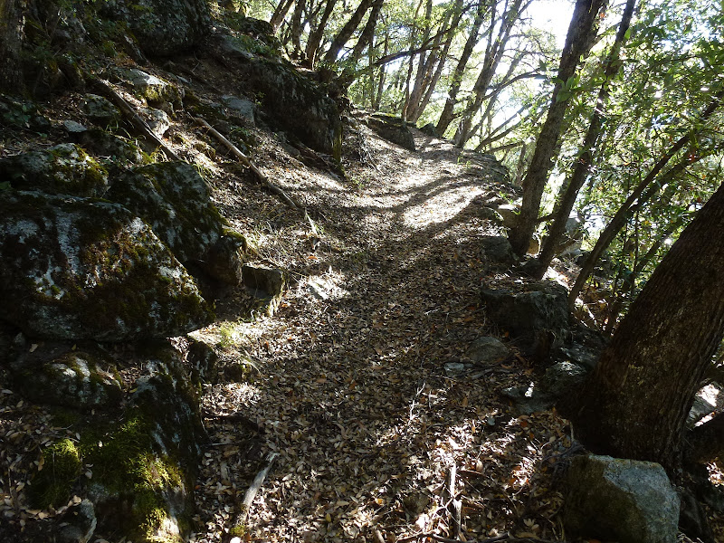
For some reason I was expecting a minimally-constructed trail, but in fact this trail had been built to about the same standard as the Yosemite Falls trail. The trail was about 3' wide and had substantial rock work. The trail is surprisingly well preserved below 5000' and above 6000'; between these elevations, either I was far off-route, or it was obliterated by rockfall.


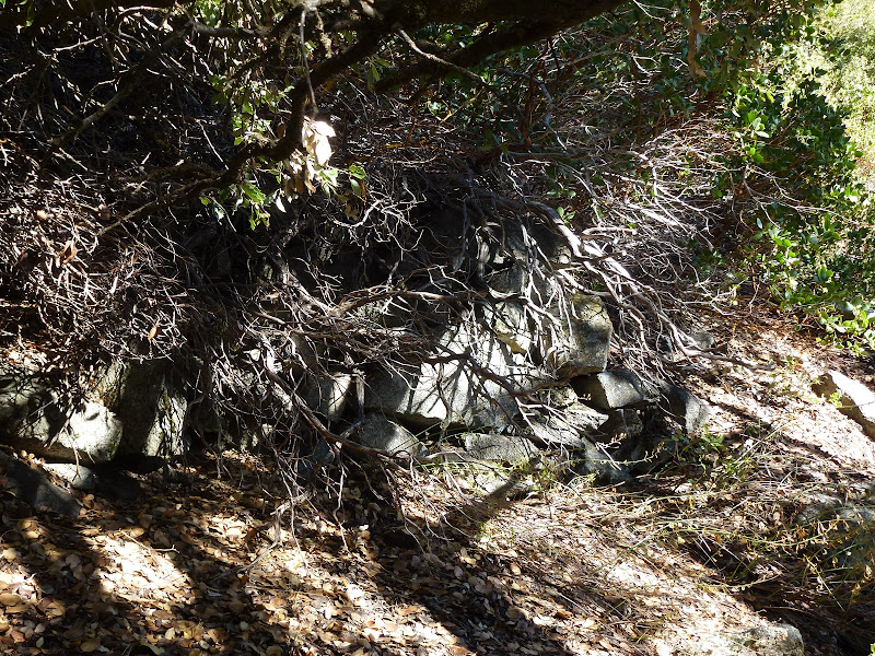
In several places mature trees and bushes are growing in the middle of what should be (based on the rock work) the trail. This was annoying since it was always easier to follow the trail than to scramble around, and in many places the trail's condition was not consistent with having a mature oak tree or manzanita bush growing in it.


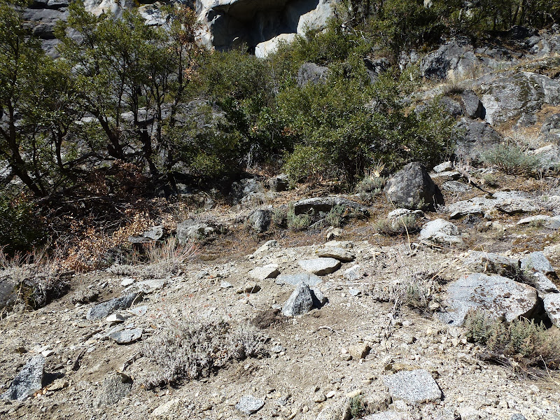
The on-"trail" portions were mostly fine, but the middle section was rough-going. The steepness was bad enough, but the slope in these sections is very unstable--footing was often a challenge. In these sections my progress was one step at a time, and more than a few times I "aid-climbed" by pulling on branches and bushes. I kicked a few rocks down that tumbled for what seemed to be hundreds of feet. Towards the top, one steep section was covered with 6" of slippery Jeffrery pine needles. In these sections it's not at all surprising that the trail was hard to maintain--or that there are no signs of it any more. Or, perhaps it's more surprising that so much of this trail still remains.


In short, for someone who likes finding and following old trails, or just likes a good scramble, Indian Canyon provides a way to make a shorter north-valley loop--although I'd still recommend the Snow Creek/North Dome/Yosemite Falls trails instead. The views are decent--but the Yos. Falls, Four Mile, and Snow Creek trails are all better.

That said, going down Indian Canyon may be preferable to the sand-on-bowling-balls slip-sliding experience that the Yosemite Falls trail has become...

More Pictures
Re: Indian Canyon
November 27, 2011 10:16PM
Thanks for the photos. Except for Chick-on and his good wife, I think that you are the only one who has reported being up there since my post.

I see that my photo link had gone bad. I'll try to fix it, but here is the key photo:


The white numbers show the route, in sequence as if you were doing it going down hill.

Yes, much of the stonework in the middle is missing. The avalanches sweep through from numbers 4 to 7 in the winter. So it's just talus and scree. But the route continues through there at the same grade. There are actually remains of a couple of nearly invisible switchbacks in that area, but they don't help...just keep plugging along below the cliffs, like it shows in Chick-on's photo...


Edited 1 time(s). Last edit at 12/17/2011 03:08PM by wherever.
Re: Indian Canyon
November 28, 2011 01:32PM
Quote
wherever
Thanks for the photos. Except for Chick-on and his good wife, I think that you are the only one who has reported being up there since my post.

I see that my photo link had gone bad. I'll try to fix it, but here is the key photo:


The little red numbers show the route, in sequence as if you were doing it going down hill.

Yes, much of the stonework in the middle is missing. The avalanches sweep through from numbers 4 to 7 in the winter. So it's just talus and scree. But the route continues through there at the same grade. There are actually remains of a couple of nearly invisible switchbacks in that area, but they don't help...just keep plugging along below the cliffs, like it shows in Chick-on's photo...
Little red numbers?? You guys are killing me, I am color blind, green and red look almost the same. Can't you make the numbers yellow, or blue or white? (I do see a 4 and a 5, but not much else)


Edited 1 time(s). Last edit at 11/28/2011 01:33PM by hotrod4x5.
Re: Indian Canyon
November 28, 2011 06:26PM
Quote
hotrod4x5
Little red numbers?? You guys are killing me, I am color blind, green and red look almost the same. Can't you make the numbers yellow, or blue or white? (I do see a 4 and a 5, but not much else)

OK. Sorry. That was one of the first pictures that I ever posted. I've sort of lost the original, and will just have to paste some bigger numbers on top of the little red ones.
See if this is better:


I think that the roof below #13 is the Yosemite Medical Center.
Re: Indian Canyon
November 29, 2011 06:33AM
Quote
wherever
Quote
hotrod4x5
Little red numbers?? You guys are killing me, I am color blind, green and red look almost the same. Can't you make the numbers yellow, or blue or white? (I do see a 4 and a 5, but not much else)

OK. Sorry. That was one of the first pictures that I ever posted. I've sort of lost the original, and will just have to paste some bigger numbers on top of the little red ones.
See if this is better:


I think that the roof below #13 is the Yosemite Medical Center.
Thank you!
Re: Indian Canyon
November 29, 2011 06:34AM
Looking at the photo, it seems like it would be less steep going up the center, the forested area. What is the reason for not going that way?
Re: Indian Canyon
November 29, 2011 07:21AM
Quote
hotrod4x5
Looking at the photo, it seems like it would be less steep going up the center, the forested area. What is the reason for not going that way?

The present-day answer is that wherever's excellent scramble-by-numbers route (thanks!) follows where the old trail is/was, and where the trail is in good shape, the going is relatively easy. Based on the reports I have read of people going up the canyon closer to the creek, it is much more rocky. Apparently the phone lines to Tuolumne ascend Indian Canyon, and there are ladders in places to help maintain them, so it is do-able. If you go this route, just hope that someone isn't on the "trail" far above kicking loose rocks down (yes, I did yell "rock!"--seems odd to do that on a solo off-trail scramble...)
avatar Re: Indian Canyon
November 29, 2011 07:33AM
Quote
hotrod4x5
Looking at the photo, it seems like it would be less steep going up the center, the forested area. What is the reason for not going that way?
Because you like to follow old trails. smiling smiley

What you are failing to realize is just how steep it is. If you do the math... it's 1 mile up and 2500 ft. gain.
And the very last portion is very very steep.

This is from just just east of the trail:

and very near the top. Which means you got one heck of climb.

I may do it one day... anyway...

I know QITNL has done the creek route... maybe he will chime in.


Chick-on is looking at you!
Re: Indian Canyon
November 29, 2011 07:45PM
Before I did the research to learn where to look for the original Indian Canyon Trail and its predecessor Indian trail, I did some scouting up from below, starting west of, but too close to, Indian Creek. Endless talus. Big boulders, small boulders, loose boulders. Endless. The actual trail is mostly on dirt and much easier. I finally found the correct route from above, where the start is much more obvious.

I never actually tried going up along the creek bed. But Hutchings described that route in his 1870 guide. This was before the Indian Canyon Trail was built, and he apparently didn't know about the Indian trail:

...Let us repair to the foot of
an almost inaccessible mountain gorge, named Indian Canyon, situ-
ated about a quarter of a mile to the east of the Yo-Semite Falls,
and nearly opposite to the hotel, for the purpose of making the
ascent. This, also, is a fatiguing and difficult task, that few have
ever undertaken.

In order the better to insure our success, we must start early in
the morning. The day may prove to be very warm ; yet, after
fairly entering the canyon, the trees and shrubs that grow between
the rocks, afford us a very grateful shelter, for a quarter of the
distance up, when the almost vertical mountain side on our right
throws its refreshing shadow across the ascent, for the greater por-
tion of the remaining distance.

Thus protected, we climb over, creep beneath, or walk around,
the huge boulders that form the bed of the gorge ; and which,
owing to their immense size, frequently compel us to make a de-
tour in the sun to avoid them, and to seek as easy an ascent as pos-
sible in the accomplishment of this, our excessively fatiguing task.

A cascade of considerable volume is leaping over this, dashing
past that, rushing between those, and gurgling among these rocks,
affording us gratuitous music, and drink, as we climb. Large pine
trees that fell across the canyon, during the rapid melting of the
snow, have been lifted up and tossed, like a skiff by an angry sea,
to the top of some huge rocks, and there left.

Onward and upward we toil, the perspiration rolling from our
brows ; but we are cheered and rewarded by the increasing novelty
and beauty of the scenes that are momentarily opening to our view
as we ascend.

About noon we can reach the summit of the mountain. It is im-
possible to describe the magnificent panorama that is here spread
out before us....


So. How hard can it be?
avatar Re: Indian Canyon
November 30, 2011 02:14PM
I like that description, but the hike up the creek is no longer that hard, thanks to some well-placed cables and ladders. The telephone line which runs from the Valley to the Tioga Road roughly follows the creek bed.

You can find some photos and a brief description here:
http://www.supertopo.com/climbing/thread.php?topic_id=1238987
http://www.qitnl.com/v/050210/

From the looks of the phone cable, I figured it was no longer used, some ancient relic - but apparently that's not the case. This connection went down over the winter and required repair this summer. You may remember there was no phone service in the Tuolumne Meadows area for a few weeks. During that spell, I noticed a number of AT&T trucks parked at the Porcupine Creek trailhead (the one with the phone booth). My guess is that is where the phone line meets the road. I wouldn't be surprised if there was a fairly decent use trail following the cable from that point.

One other note: the talus field behind the stables (noted as "you've gone too far" above) is the start for the Sunnyside Bench hike. After you reach the top of the slide and take a hard left turn over to the bench, you'll find another use trail that heads in the opposite direction, to the right. I bet this trail meets up with the Indian Creek trail somewhere around marker 11 on the photo above.
avatar Re: Indian Canyon
November 30, 2011 03:20PM
Bowing to his greatness Thanks Joe... rekindles my desire to go that way someday...


Chick-on is looking at you!
Re: Indian Canyon
November 27, 2011 10:17PM
Thanks! Nice pictures and report. I was planning on doing that exact route on Nov 6, but a few inches of snow the previous day persuaded me to try something tamer.
avatar Re: Indian Canyon
November 28, 2011 06:37AM
Kewl. Been up once and down once now. Came down with backpack when did Snow Creek/Basket Dome:
http://yosemitenews.info/forum/read.php?3,29798

Just a note. Every time that the wifey and I have been in the valley since first going up Indian Canyon in Oct. of 2010..
I say to her "Indian Canyon" to which she replies "no friggin way" or "you can, I'm not!".
It is just supa dupa steep in a number of spots.
You have been warned (again).

Have fun


Chick-on is looking at you!
avatar Re: Indian Canyon
November 29, 2011 12:18AM
So to find the start I'd start behind the Med Center, not Church Bowl?

Start at Church Bowl, head towards the Med Center on the rim trail, look to the right for something that looks like a good startup?
Re: Indian Canyon
November 29, 2011 07:10AM
Quote
qumqats
So to find the start I'd start behind the Med Center, not Church Bowl?

Start at Church Bowl, head towards the Med Center on the rim trail, look to the right for something that looks like a good startup?

Yes... If you get to the open talus field with large rocks and a good view of Lost Arrow, you have gone too far. I would add that if you're not comfortable with something like locating and climbing the old the old trail to Sierra Point, Indian Canyon may be a bit ambitious...
avatar Re: Indian Canyon
November 29, 2011 07:17AM
Quote
basilbop
Quote
qumqats
So to find the start I'd start behind the Med Center, not Church Bowl?

Start at Church Bowl, head towards the Med Center on the rim trail, look to the right for something that looks like a good startup?

Yes... If you get to the open talus field with large rocks and a good view of Lost Arrow, you have gone too far. I would add that if you're not comfortable with something like locating and climbing the old the old trail to Sierra Point, Indian Canyon may be a bit ambitious...

Exacta-mundo.

Z start of the trail:


See this? Then go back east and look again:


Chick-on is looking at you!
Re: Indian Canyon
August 05, 2018 05:00PM
With a Sept. trip to the Park starting to take shape, I'm
once again looking for something scary to do. I've tried
to find the trail head to Indian Canyon twice and failed
both times. I'm going to copy the photo of the starting
spot offered in this thread and see if the third time is
a charm. A question about this hike: Is it even worth
looking for the trail head at the TOP of the canyon, or
is it even tougher to find?

I was once overwhelmed by the prospects of doing the
Ledge Trail, but got little slice of heaven out of my system.
Now, I can't quite thinking about this hike.

Maybe I should go back to collecting dust bunnies.
Re: Indian Canyon
August 06, 2018 09:15AM
The Indian Canyon trail is definitely easier to find from the bottom than the top, so I'd start there. Chick-on and I have both done the "trail" and we struggled to find it from the top. And, even once on it, it's very overgrown at the top, hiding whatever rockwork or other signs of the "trail" still exist.

Also, going up, it will be easier to turn around and go back down if you find out that Indian Canyon is not your cup of tea. The "turn around" option starting from the top isn't nearly as attractive...
Re: Indian Canyon
August 07, 2018 06:47PM
Thank you for the expertise. The bottom it is.
Sorry, only registered users may post in this forum.

Click here to login