Welcome! Log In Create A New Profile Recent Posts
Nevada Falls

The Moon is Waxing Gibbous (59% of Full)


Advanced

Tenaya Lake to Lone Boulder

All posts are those of the individual authors and the owner of this site does not endorse them. Content should be considered opinion and not fact until verified independently.

Tenaya Lake to Lone Boulder
May 21, 2012 07:45PM
This weekend: a short dayhike along the wonderful stretch of Tenaya Creek between Tenaya Lake and the Lone Boulder. Despite the general warnings about the dangers of travel into Tenaya Canyon, this upper segment is mostly easy and safe cross-country travel. If you like open, polished granite and clear pools, and cascades, and don't mind some cross-country travel, add this one to your bucket list.

We started at the Sunrise Trailhead and left the trail at the first indication it was going up and away from Tenaya Creek, over a low rocky ridge. The cross-country travel from here was straightforward until the creek enters a narrow slot. Near here, on the opposite (west) shore is a sign warning of dangers ahead. This is informally known as "Admonition Point". (Yes, we did return to Tioga Road--eventually.)


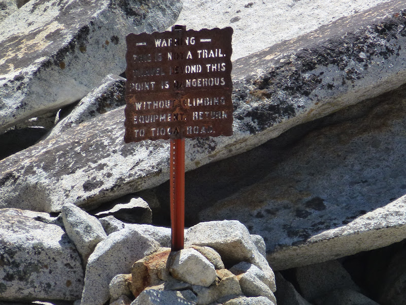
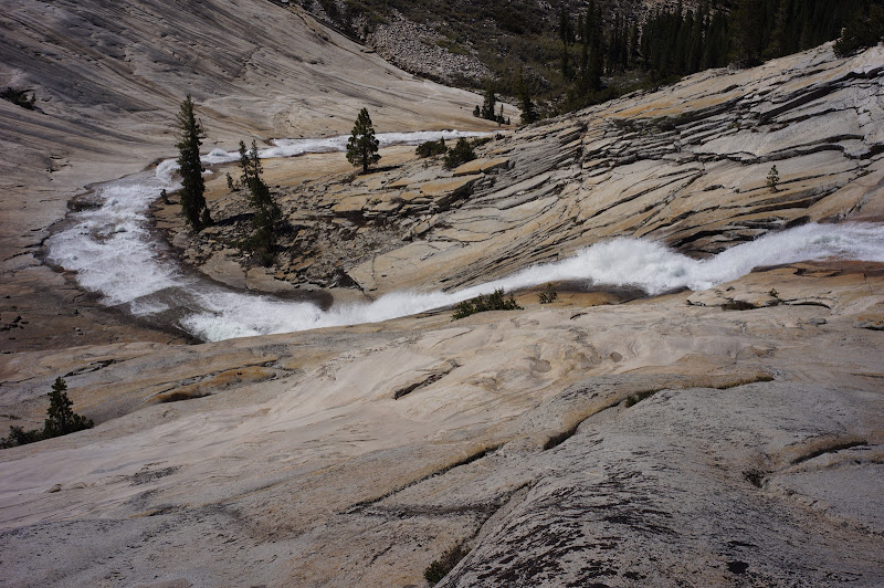
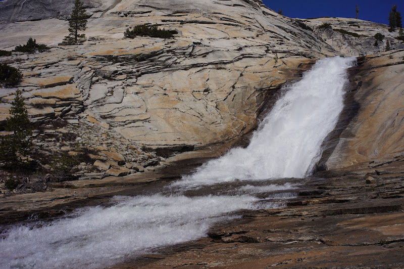
Some trip descriptions suggest crossing the creek, but I can see no reason for this other than being able to read the admonition: the west side of the creek does get tight, but the left is passable, and just below the sign is the highlight of the trip: a cascade dropping into a large, open granite bowl, with the creek gracefully curving around before its final plunge into generically-named "Glacial Valley". (There is a less-steep gulley just east of the creek here that could also be used to enter "Glacial Valley".)


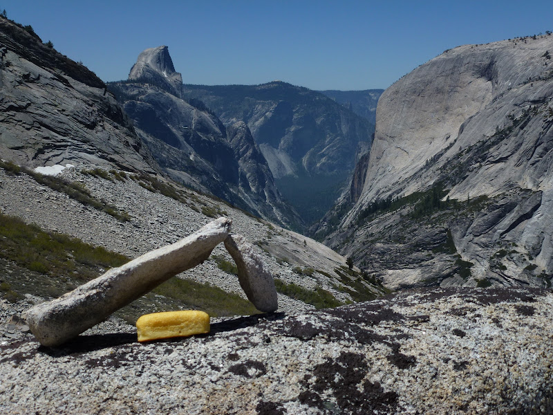
Below this granite bowl--a worthy destination on its own--travel is generally good, except for a messy section near the creek from Sunrise Mountain. Past this creek, the terrain changes from open forest and granite slabs to brush and talus. A final climb up a granite slope leads to the infamous Lone Boulder, with excellent views into Tenaya Canyon. (This is also the end of the "easy" part of the route down Tenaya Canyon and would be a more appropriate location for the "admonition" sign...)


Conditions: There was basically no snow along Tenaya Creek or going around Pothole Dome. There were a few mosquitoes out at the Sunrise trailhead. There were no sightings of pink birds. Strange, this seems to be their preferred habitat.

More Pictures
avatar Re: Tenaya Lake to Lone Boulder
May 21, 2012 07:50PM
Is that a new twinkee?

(nice pictures, thanks)
avatar Re: Tenaya Lake to Lone Boulder
May 21, 2012 07:58PM
A week late... again...


Looks like it is down a tad bit from last last weekend.

Berry Kewl. And thanks for making me have to go find that darn sign now!

Tanks for Sharon


Chick-on is looking at you!
avatar Re: Tenaya Lake to Lone Boulder
May 21, 2012 08:01PM
Peeps may want to peek at this one again for some comparison:

http://yosemitenews.info/forum/read.php?3,50759


Chick-on is looking at you!
Re: Tenaya Lake to Lone Boulder
May 21, 2012 08:08PM
Quote
chick-on
A week late... again...

Berry Kewl. And thanks for making me have to go find that darn sign now!

Tanks for Sharon

think its right before it drops down into the polished granite area. I always follow the outlet but ive heard its easier (not that its hard) to follow the sunrise trail for about a mile than cut across.
Think water will be low enough to do the entire canyon early July?
avatar Re: Tenaya Lake to Lone Boulder
May 21, 2012 08:29PM
That bowl is one of the more spectacular spots in the park.


Old Dude
avatar Re: Tenaya Lake to Lone Boulder
May 21, 2012 09:30PM
Quote
ryanmj
I always follow the outlet but ive heard its easier (not that its hard) to follow the sunrise trail for about a mile than cut across.
Think water will be low enough to do the entire canyon early July?
I went in that way last last weekend. And then back out following the creek. It doesn't matter.
All ways are fairly trivial. Not sure the need for cairns... so I knocked them all down.
I mean, really, how you gonna get lost? You're following the creek...

Early July may still be too early. Prob. mid to late July is my guess when the flow out of Tenaya will be down to
a trickle.


Chick-on is looking at you!
Re: Tenaya Lake to Lone Boulder
May 21, 2012 09:55PM
Quote
chick-on

And thanks for making me have to go find that darn sign now!

Tanks for Sharon

Ah, I love this thread. We missed the sign also. But that was the least important thing we missed on our trek last year.
avatar Re: Tenaya Lake to Lone Boulder
May 21, 2012 09:26PM
Quote
basilbop
Some trip descriptions suggest crossing the creek

I've gone down it both ways ... and both ways were fairly simple imo
except maybe the Av. Gully close to where you go up to the Lone Boulder.
The N side is maybe slightly more open and easier... if you can cross
just above the last pool down by the trees.. but then you have to
cross again at some point if you want to go to the Lone Boulder...

You could take the ridge E of Olmsted (BM 8664) all the way and drop
down onto the top of Pywiack and cross there too. I did most of that
ridge and it is spectacular.


Chick-on is looking at you!
avatar Re: Tenaya Lake to Lone Boulder
May 21, 2012 09:51PM
OK. Funny. Looked at a few sets of mine... and I have numerous photos of the sign.
I dunno... why the heck would you be on that side? Seems a crappy spot to have it.
I mean, you're gonna traverse the canyon. The south side certainly isn't difficult at that point.


Thanks Basil!


Chick-on is looking at you!
Re: Tenaya Lake to Lone Boulder
August 05, 2012 07:55PM
Did this as a day hike on 1 August. I'd been to the rock bowl twice before, my favorite place in the park, but this time I did the entire upper canyon. Coming up from the flats into the rock bowl gave me a view of it that I'd never seen before, a complete lunar landscape, an ocean of granite.

I've also found it easier to scramble up the granite to the south of Tenaya Creek from the narrows where the sign is and come into the rock bowl from above than to boulder/big rock the creek in. This route elimintes two crossings of the creek which was not a big deal this time but can be.

I hiked for six hours and did not see another soul. The creek was bone dry until the stream that runs off of Sunrise joined the Teneya Creekbed, resulting in what appeared to be stagnant pools at the water table. One interesting thing was that at one point in the stream bed, water flowed over a tiny lip of granite where it did not pool or flow, just disappeared. It seems like the glacial polished surface is coming loose from the underlying granite and creates a tunnel like effect.

Here are the pix:

https://picasaweb.google.com/110580852447260035638/YosemiteNationalParkUpperTenayaCanyon

The only downside was to my backside, scrambling down the talus slope to the east of Lone Bolder, let's just say that the rocks are not fully consolidated and one flipped on me and scraped my tush. Lone Boulder itself was a bit of a schlep, and all of the walking on hard, sloped granite did not do my knees any favors for the next day's hike to Bunnell Falls.

I should count myself lucky and with humility that the spirit of Chief Tenaya let me off so easily.


Edited 1 time(s). Last edit at 08/05/2012 08:00PM by marcos.
Re: Tenaya Lake to Lone Boulder
August 05, 2012 09:02PM
does that creek run out of Tenaya Lake? I am just wondering where to locate this of Hwy 120. Also, does the creek run along where Clouds Rest would be or is the drop off before that. Just wondering, I want to go there. Looks like a real nice place to do some easy cross country and to hit some nice pools to swim!
________________

West Fork Trail-the most popular trail on the Coconino National Forest.


Edited 1 time(s). Last edit at 08/05/2012 09:02PM by redfox1939.
Sorry, only registered users may post in this forum.

Click here to login