All posts are those of the individual authors and the owner of this site does not endorse them. Content should be considered opinion and not fact until verified independently.

Ostrander Rocks and Illilouette Ridge
June 11, 2012 07:49PM
We were looking for an easy "day off" hike on Friday, so we did some off-trail hiking at Ostrander Rocks and Illilouette Ridge. Perfect day. Gorgeous easy hike. No people. I'll add this to my list of short family "bushwhacks".


I would have sworn that Chick-on or somebody recently posted about this hike. But all I can find is this link: Illilouette Ridge

We first hiked over to the rocks, and decided that there was no easy way up the highest (north) one. Then back to Illilouette Ridge and along it to its north end, which is close to the parking lot for Sentinel Dome. Didn't see a soul until we hit the lot. One guy had gone back along the ridge to get the car and bring to the to Sentinel Dome lot.

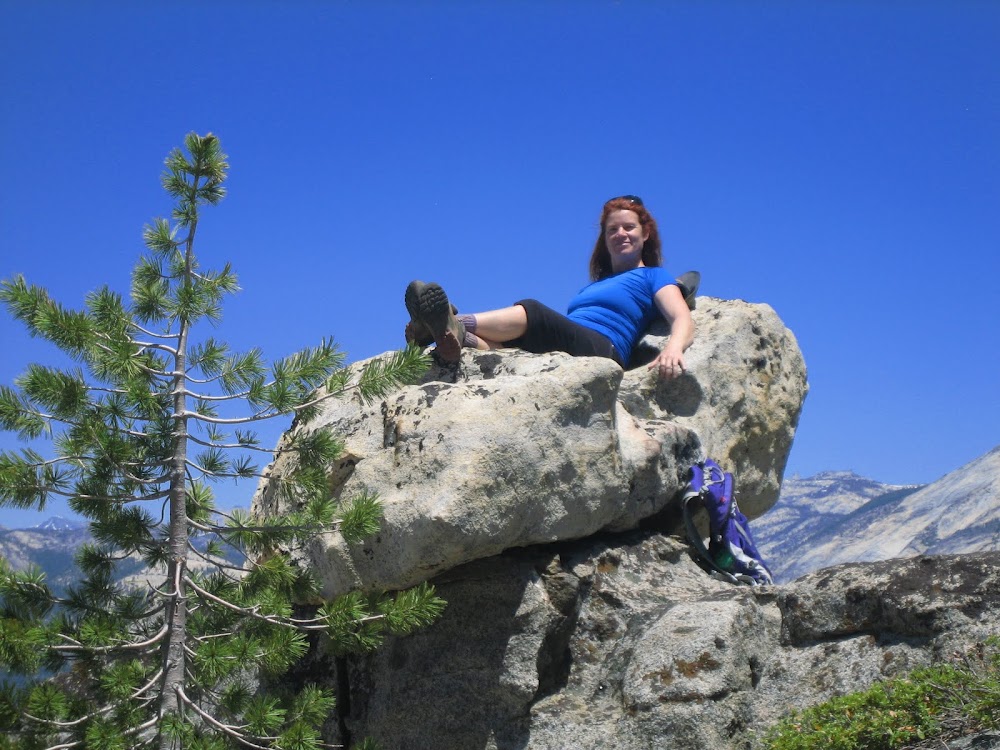
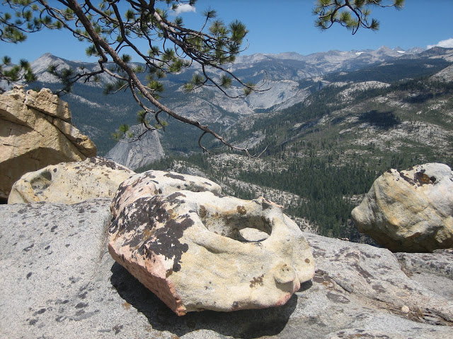
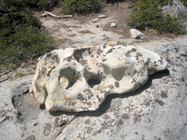
Our only problem was a mostly dead camera battery. We will have to go back and take more photos. Here is a photo of a neat rock with a horizontal hole and a black-looking vertical one that goes all the way through.


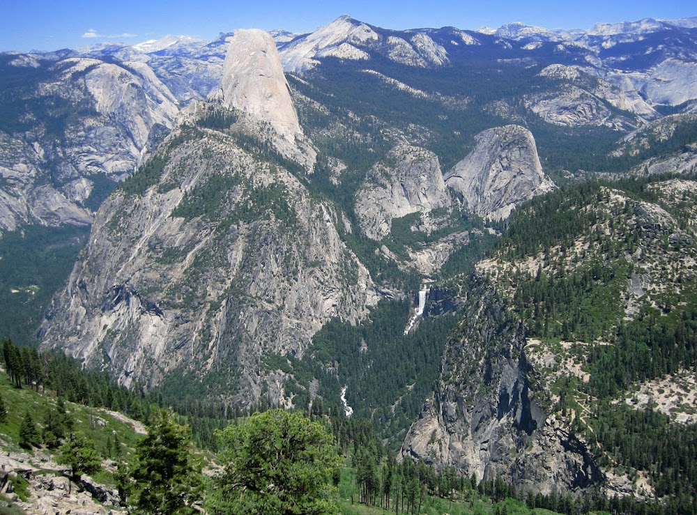
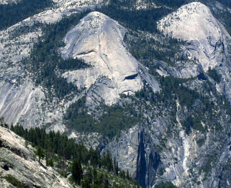
Here is a view of North Dome, Basket Dome, and the tops of Washington Column and the North Dome Gully.


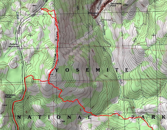
The hike along the ridge is 2.5 miles. I recommend doing it from south to north, because the views just keep getting better and better as you go along.

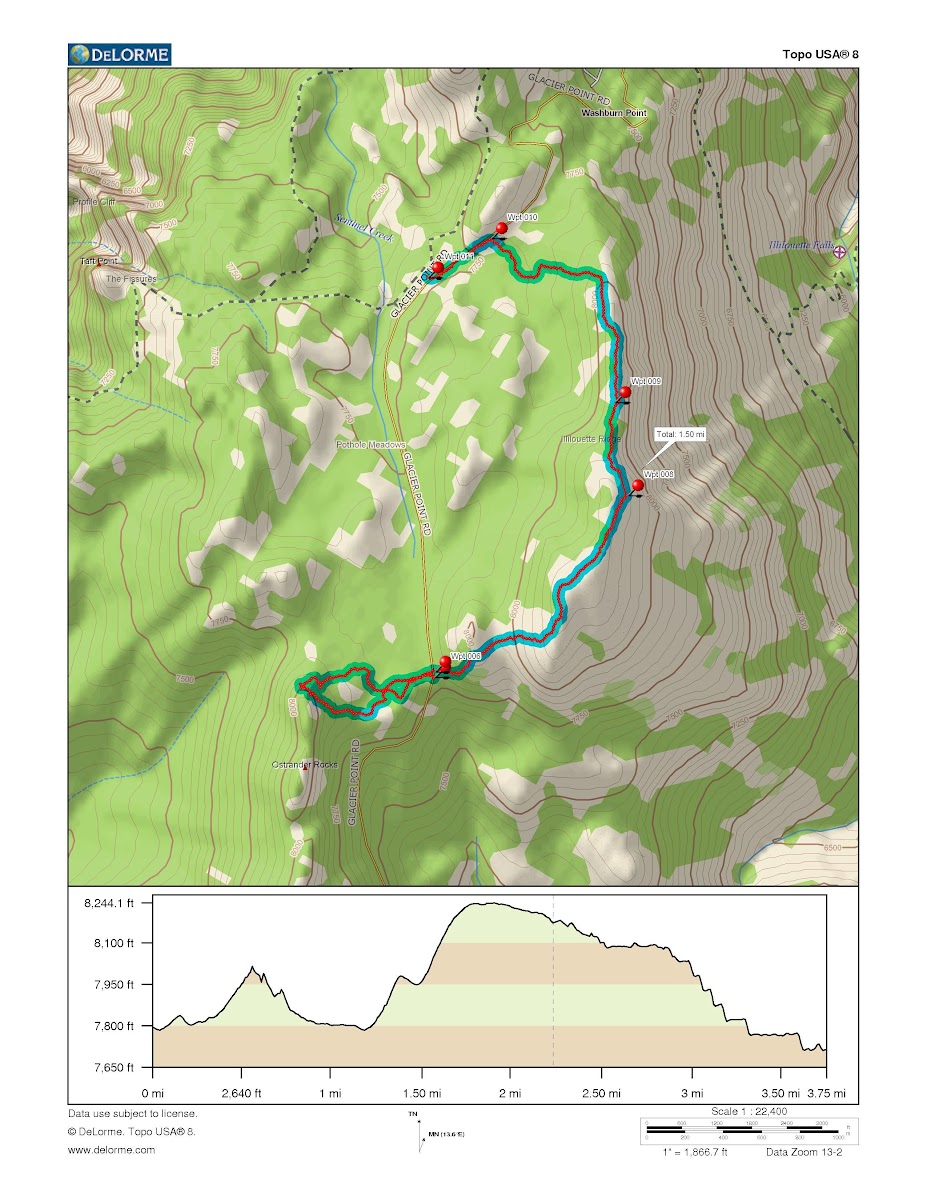
You can park on the wide shoulder of the road, which is visibly between the ridge and the rocks. Waypoint 6 on the map. After hiking to the north end of the ridge, just hook back to the parking lot, waypoint 11 on the map. If you don't want to do a car spot, just park at Sentinel Dome lot and hike up from across the road.


Edited 1 time(s). Last edit at 06/13/2012 10:56AM by wherever.
Re: Ostrander Rocks and Illiouette Ridge
June 13, 2012 08:20AM
After a late morning bike ride in the valley, my husband and I drove up to Washburn and Glacier Point on Friday (no hiking.) It was indeed a beautiful day...many days of the week were what I call HD. If you're wearing polarized sunglasses, you can't believe your eyes how clear it is...so many details visible.
avatar Re: Ostrander Rocks and Illilouette Ridge
June 13, 2012 12:48PM
If you're only going to go to the best view on the north end of the ridge, the best place to park is the G9 turnout.
This about 1/4 of a mile past the Sentinel Dome parking lot towards Glacier Point.
message post with G9 photo
avatar Re: Ostrander Rocks and Illilouette Ridge
June 20, 2012 06:53AM
You reminded me how cool this ridge is... so we (read I) decided to
start our trek up to Hoover Lakes at G9. Missed the holey rock on way in...
got it on the way out ... thanks. It's a sweet ridge. Wife loved it.
You can also park at waypt. 6 in the photo above. There is some old
tele-something wire and knobs that runs b/t GP rd and the first knob east
of it. Also the little saddle between that knob and Ill Ridge... to me ... that
kind of stuff is what I just love about Yosemite. Great little open area that
you wouldn't expect.


Chick-on is looking at you!
Re: Ostrander Rocks and Illilouette Ridge
June 20, 2012 09:31AM
Quote
chick-on
You reminded me how cool this ridge is... so we (read I) decided to
start our trek up to Hoover Lakes at G9. Missed the holey rock on way in...
got it on the way out ... thanks. It's a sweet ridge. Wife loved it.
You can also park at waypt. 6 in the photo above. There is some old
tele-something wire and knobs that runs b/t GP rd and the first knob east
of it. Also the little saddle between that knob and Ill Ridge... to me ... that
kind of stuff is what I just love about Yosemite. Great little open area that
you wouldn't expect.

You know that I like to find old artifacts. We did park at waypoint 6 and hiked up from there, but didn't see any telephone wire. We saw something interesting at the north end of the hike. In the flat woods at the north end of the hike, halfway between the ridge and the road, where my track makes a little detour. Someone had bulldozed an open trench (more than a hundred feet long) in the ground and used it as a dump. Hundreds of bottles, rusted steel cans, and some bigger stuff. No aluminum soda cans or pop tops. I figure it dates back to before the burning down of the Glacier Point Hotel. When the hotel died, they just walked away from it. That would make it fifty years old, or older. My camera was dead when I was there, but I plan to go back some time and get photos to embarrass the Park Service with. And see if I can find something to put a date on the place.

Maybe I'm confused, but G9 is a strange place to start a hike to Hoover Lakes. Did you hike down to Glacier Point and out that way, or did you head south and down the ridge?

Here is Chick-on's photo of G9. It's at the high point adjacent to Sentinel Dome. https://lh5.googleusercontent.com/-SF-H_x3AxkM/TkMf8WmM9LI/AAAAAAAARnA/SCgOLkTF_B8/s1600/P1250728.JPG


Edited 1 time(s). Last edit at 06/20/2012 09:32AM by wherever.
avatar Re: Ostrander Rocks and Illilouette Ridge
June 20, 2012 09:44PM
Hmm... well I guess that explains these:

I didn't run into any this time... this photo is from 2010 when first went up there. I went further north
this time both in and out and didn't see any bottles. I'll have to go back and check it out.

Here's the wire... I took this for you. (I know you like this stuff):

I don't see this line on any old maps that I looked at.

As for a strange route to Hoover Lakes... well... sure... looked like this:

I have the entire route if really interested... but this is the area in question.
(the theory was ... if I can hike on 41 from Grouse to Chinquapin... I can do this little bit... )
And we were laughing on account the VERY first thing we had to do was crawl over a log the second we
got onto the Mono Mdw trail. Precious.

The hike down was steep but interesting...


And the creek... that is a Yosemite Nugget of Gold...


Chick-on is looking at you!
Re: Ostrander Rocks and Illilouette Ridge
June 10, 2013 02:48PM
It was too hot on Saturday to do our planned hike on the Snow Creek Trail. So we did the Illilouette Ridge instead. Absolutely one of the best beginner bushwhacks. Less than three miles long, less than 400 feet of vertical rise at the beginning (we started at the south end). Great views to the north and east.


There are lots of interesting rocks. Like the holey rock mentioned earlier on this thread. Like "Fred Flintstone meets the Queen of Sheba":

avatar Re: Ostrander Rocks and Illilouette Ridge
June 11, 2013 07:46AM
How come ur buddie didn't traverse Ostrander? smiling smiley

There's a really good way to Washburn Point from Ill. Ridge... well... really good in winter:
http://yosemitenews.info/forum/read.php?3,63610,63610#msg-63610

I was hoping you would go in search of the lost Peregoy Meadow Trail.
It would complete a nice loop... although I'm more interested in if there is any rockwork
still present (if there ever was any really)... west of Ost. Rocks.


Chick-on is looking at you!
Re: Ostrander Rocks and Illilouette Ridge
June 11, 2013 12:33PM
Quote
chick-on
I was hoping you would go in search of the lost Peregoy Meadow Trail.
It would complete a nice loop... although I'm more interested in if there is any rockwork
still present (if there ever was any really)... west of Ost. Rocks.

What? There is a lost trail that I never heard of? Time to hit the old maps again....
avatar Re: Ostrander Rocks and Illilouette Ridge
June 11, 2013 01:57PM
Quote
wherever
Quote
chick-on

I was hoping you would go in search of the lost Peregoy Meadow Trail.
It would complete a nice loop... although I'm more interested in if there is any rockwork
still present (if there ever was any really)... west of Ost. Rocks.

What? There is a lost trail that I never heard of? Time to hit the old maps again....


To whet your appetite a bit more:

“Born in Baltimore (1826) Charles Peregoy came to California in search of gold (1849). He engaged in mining in Calaveras and Mariposa counties. Sometime in the 1850's Peregoy bought a ranch at Mormon Bar about two miles from the town of Mariposa. Shortly after Charles Peregoy made the final payment on the Mormon Bar ranch, John C. Fremont claimed the land as part of his Mexican land grant and demanded that Peregoy pay him rent on his property. The latter refused and took the case to court where it was litigated for seventeen years before finally being settled in Peregoy's favor. Faced with the possibly of losing his property, he decided to concentrate on stock raising rather than making costly improvements on the land. During the summer months Peregoy drove his cattle through Mormon Bar, past Clark's Station (Wawona) and up toward Glacier Point to the spot later known as Peregoy Meadows. Here he established a cattle camp and lived with his wife and five children during the summer.

In the late 1860's tourist travel into Yosemite increased considerably. Tourists could travel by stage as far as White and Hatch's mill on Chowchilla Mountain. They made the remainder of the trip on horseback as there was then no roads into the Valley. Tourists took the trail from White and Hatch's to Clark's Station, where they stopped to visit the Big Trees. The next day they usually rode to Inspiration Point then down to the Valley floor. The trail led past the Peregoy cattle camp and many weary travelers stopped to ask for food or a night's lodging, so Charles and Mary decided to put up a small hotel, called Mountain View House (1869). This consisted of two buildings with accommodations for sixteen people. Mountain View House ceased to be important as an overnight stopping place when wagon roads from Coulterville, Big Oak Flat, and Wawona were completed (1875). Charles Peregoy died in Mariposa (1904) at the age of 78. The inn was not used after 1919 and was dismantled by a Civil Conservation Corps crew during the 1930s. The location of the fireplace is still barely visible. See Pacific Historian vol. 6, no. 3, pp. 123-128. "Charles and Mary Agnes Peregoy--Yosemite Pioneers" by Bea Peregoy (Great-Granddaughter). "


Register of the Mountain View House (Peregoy Meadows, Calif.) Hotel Register, 1869-1878


Edited 1 time(s). Last edit at 06/11/2013 01:58PM by plawrence.
Re: Ostrander Rocks and Illilouette Ridge
June 11, 2013 02:26PM
OK. I concede. You two have already mentioned this.
http://yosemitenews.info/forum/read.php?3,54523,54580#msg-54580

Do you have the portion of that old map that shows more of the trail?
Re: Ostrander Rocks and Illilouette Ridge
June 11, 2013 03:01PM
According to Browning's place names book, Peregoy's meadow and hotel sat exactly where the current Bridalveil Campground is located. He and his wife ran it until 1878.

So the trail would be the original alignment of the Glacier Point Road.
avatar Re: Ostrander Rocks and Illilouette Ridge
June 11, 2013 04:53PM
Not exactly. It looks like this:


You can find the Pothole Mdw section on this map in greater detail:
http://gisserver.princeton.edu:81/navigatorMapViewer.htm?map=911


Chick-on is looking at you!
Re: Ostrander Rocks and Illilouette Ridge
June 11, 2013 08:16PM
Quote
chick-on
Not exactly. It looks like this:


You can find the Pothole Mdw section on this map in greater detail:
http://gisserver.princeton.edu:81/navigatorMapViewer.htm?map=911

Hm. I don't believe for a minute that the trail went over that lump next to Ostrander Rocks. Otherwise, it's all about the stream crossing of Bridalveil Creek, isn't it. I see that you show two versions of the Glacier Point Road, but they still cross on the same bridge.

I'm sure that there is/was something there. It would be worth a look. But remember that the Peregoys were cattle or sheep people. The trail shown might be more of a cowpath...


Edited 1 time(s). Last edit at 06/11/2013 08:17PM by wherever.
avatar Re: Ostrander Rocks and Illilouette Ridge
June 11, 2013 10:22PM
Looks to me like it was a "real" trail from 1918 to 1938 and beyond. I don't see it
on 1948 map. So there is hope... although there's a whole lotta woods there so... it
may not be discernible. The red line drawn in the map above is the current alignment
of the GP road. The black line... I just drew over the dotted trail so it would be
obvious what trail talking about. In the Princeton link you can see where the trail goes..
unfortunately it's cut off... as those old maps are simply amazing..
ok... to be clearer... I drew in the trail on a modern map... simply by looking at the
old map... I'll overlay it someday when I have more time and am willing to go look.
(I have a bunch of other old trails still to go in search of) (and canyons and domes to explore)


Chick-on is looking at you!
Sorry, only registered users may post in this forum.

Click here to login