Welcome! Log In Create A New Profile Recent Posts
Yosemite Valley

The Moon is Waxing Gibbous (77% of Full)

JanSport


Advanced

Re: 2012 Yosemite trip; Part 1, Rockslides to Cascade Creek

All posts are those of the individual authors and the owner of this site does not endorse them. Content should be considered opinion and not fact until verified independently.

2012 Yosemite trip; Part 1, Rockslides to Cascade Creek
September 29, 2012 09:26PM
2012 Yosemite trip; Part 1, Rockslides to Cascade Creek

Yosemite 2012 trip. Day 2: Cascade Creek to Yosemite Falls

2012 Yosemite Trip, Part 3 (days 3-5): YOsemite FAlls to Olmsted Point and May Lake

2012 Yosemite Trip, Part 4 (days 6-8); Tuolumne Meadows, Glen Aulin, Cold Canyon, Miller Lake, Matterhorn Canyon, Burro Pass

2012 Yosemite Trip, Part 5 (days 9 and 10): Slide Canyon; Mule Pass; Crown, Robinson, Peeler Lakes; Kerrick Canyon, Peeler Lake, Rodgers Lake

2012 Yosemite Trip, Part 6 (days 11-13): Rodgers Lake, Rodgers Meadow, Pate Valley Grand Canyon of the Tuolumne, Waterwheel Falls, Le Conte Falls, Tuolumne Meadows

Aerial pics from plane of Northern Yosemite

A few words a pictures from our Yosemite backpacking trip: July 19 - July 31 (13 days of backpacking).

We travelled from Nashville and Cleveland to Sacramento, then used the Amtrak system to Merced, and the YARTS system to travel into Yosemite Valley. We arrived in the valley on July 18th, and after setting up camp in the backpackers camp, buying fuel, getting permits, renting bear canisters for my nephews, talking to rangers, and eating, we decided to wander up from the backpackers camp to Mirror Lake. Upon arriving we never saw a lake. We barely saw a puddle. I have never been there before so do not know what it normally looks like, but I am wondering if the following picture is where the lake might normally reside.


The next morning we took our time getting packed up and moving. We were beginning our hiking adventures on this day, but the route was relatively short. The first four days would take us form the Valley at the Rockslides trailhead up to the Cascade Creek footbridge and then along the North Rim past El Capitan, Eagle Peak, Yosemite Falls, YOsemite POInt, North Dome, Indian Rock, Snow Creek, and ending at Olmsted Point on Tioga Road where we would catch the shuttle to the Tuolumne Meadows backpacking campground.

We took the El Capitan shuttle to the trailhead or near it (or so I though). In retrospect it may have made sense to go to the next stop. We walked for a while along a trail on the north side of the road past El Capitan until it merged with the Old Big Old Flat Road. This was near the Rockslides Trailhead. There we began walking along the old road, a task that was regularly interrupted by rockslides, washouts, etc. Here is a view east from the old road.


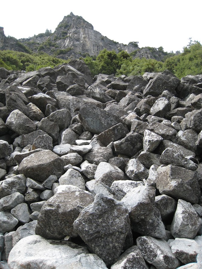
To be completely truthful, I found the rockslides a little unnerving when I thought about it a bit. Rocks (both relatively small, and quite large) covered a wide swath looking uphill beside the trail and also looking downhill. It was clear that we were the things that were out of place here. In fact, the rockslide was so imposing on the uphill side that it felt as though it could all "readjust" at any moment and we would be toast. Perhaps the rocks have not moved since coming to rest back in the 1940's (or whenever it occurred). On the other hand.....


There were several sections of the road that were washed out. I believe the section below is a section we had to pass through (that is, before the uphill climb). While negotiating the various obstacles we ran into a Search and Rescue group that appeared to be from some surrounding community based on their shirts. They were in bright neon colors, had very very small packs, and were moving very quickly downhill. When they saw us with our large heavy packs moving uphill they gave us one of those "looks" and wished us well.


Finally we came to the section we had all been wondering about -- the section of the rockslide where we had to head up the rockslide itself to meet up with the top section of the road "switchbacks". One of the nephews eagle eyes came in useful as he quickly spotted the rock "wall" at one end of a switchback that would be our target. It was not a walk in the park. Finding a path, balancing the heavy pack, and keeping on target required considerable effort. Some of the smaller rocks actually MOVE. That makes it interesting. Some of the "space" between rocks goes down rather deep. Again, there was an acute awareness of how soft and squishy people are compared to rocks, an awareness heightened by being in the midst of a stream of rocks that at some point actually flowed for a bit. Eventually we made our target, and once back in the edge of the woods on the old road, stopped to rest for a bit.


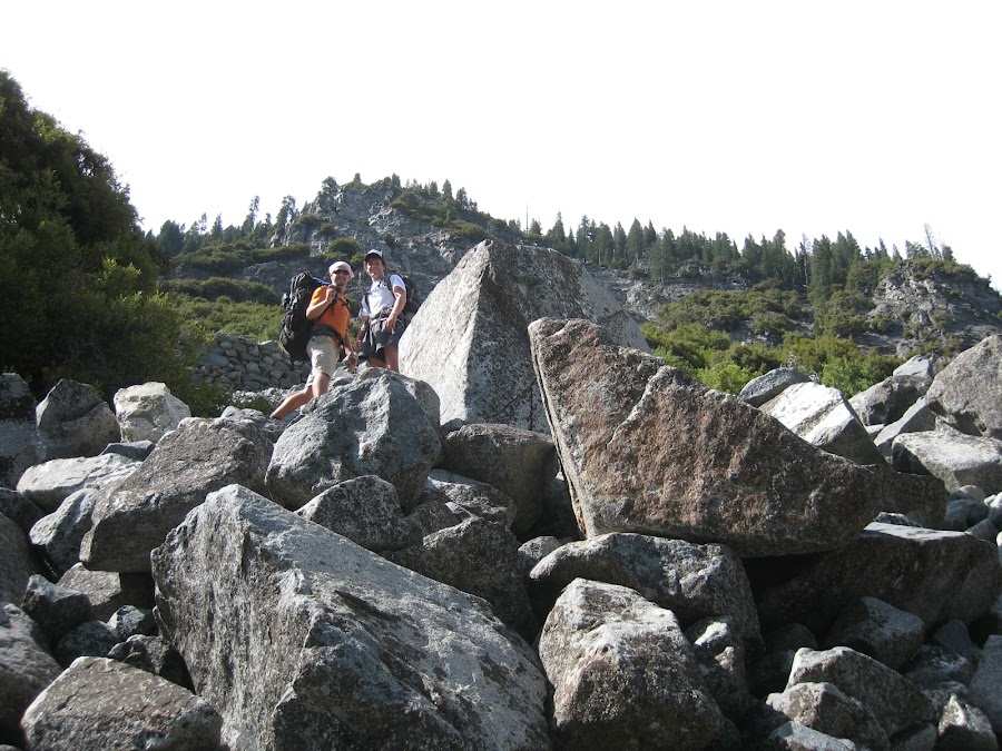
This is looking back from where we had just come, although in truth in shows only a small portion. The rock "wall" of the road is visible just left of the center and the main part of the climb up lie beyond and down from that.


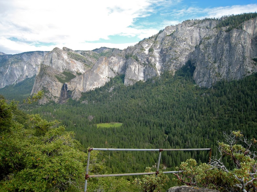
I dont' know where this is. Maybe Inspiration point?


Is this inspiration point?


Once beyond the rockslides the going was pretty easy as the Old Big Oak Flat Road moved steadily upwards through a pine forest. Most of the walking was on a bed of pine needles, with the old road occasionally showing through.


We made it to the Cascade Creek footbridge and the most obvious camping spot, up on a large granite shelf to the left of the trail overlooking the creek, was occupied by a group of kids with a few adults for some type of boys camp. So, we ended up camping on the north side of the bridge not far from the trail. Further back there was a great swimming hole that was deep and quite cold. One of the nephews insisted on jumping in, and rather miraculously was back out in about the same amount of time it took to get in. It was the coldest water we would encounter during the next 13 days.

That night was a new moon. We spent some time laying on the footbridge staring into the universe, or more precisely the Milky Way, the center of which made itself very visible. It's amazing the number of stars that appear in certain areas of the sky under a new moon in a remote area. This was not a Nashville or Cleveland sky.


It's very possible some of the identifications I have made or will make will be wrong. Please correct if you are inclined to do so.


Edited 4 time(s). Last edit at 02/19/2023 03:39PM by Frank.
avatar Re: 2012 Yosemite trip; Part 1, Rockslides to Cascade Creek
September 30, 2012 07:33AM
Mirror Lake, geologically speaking, is in its death throes. Eventually, many lakes fill in with sediment to the point where they evolve into meadows. That's what's happening to Mirror Lake.

Thanks for the trip report.
Re: 2012 Yosemite trip; Part 1, Rockslides to Cascade Creek
September 30, 2012 10:51AM
Nice photos. Thanks.

Mirror Lake was formed a few hundred years ago, when 11 million cubic meters of rock fell off the side of Washington Column. It formed a dam at least a hundred feet high. Since then, the dam has been eroding and the lake filling in with sediment. It's pretty much gone now. Early photos of the park show that it was still a pretty good lake at that time. The sand mining by the rangers was an attempt to restore the lake to what it had been in the early days...

http://landslides.usgs.gov/docs/wieczorek/reg015-08.pdf

The rockslides on the Old Big Oak Flat Road are a different matter. There wasn't any gigantic rockfall in modern times. Instead, the whole talus field moves slowly during the freeze and thaw each winter. There will be groups of boulders tumbling, but nothing that would produce the apparent disaster that you see.
avatar Re: 2012 Yosemite trip; Part 1, Rockslides to Cascade Creek
September 30, 2012 10:39AM
Your top picture is of Upper Mirror "Lake", here's another view from the day after Thanksgiving, 2011:

Re: 2012 Yosemite trip; Part 1, Rockslides to Cascade Creek
September 30, 2012 01:51PM
Great report...I'm not clear if this was your first trip to the park or just the first time you've been to some of these locations but if, as I suspect, it's your first visit to the park, what a fabulously far-reaching route you've chosen!

The railing you saw is most commonly known as Rainbow View (for the views of the rainbows that often surround Bridalveil Fall across the Valley). The name Inspiration Point has actually been applied to a number of locations over the years. The original one (now commonly known as Old Inspiration Point) was along the horse trail the Mann Brothers built from Wawona up to the south side of the Valley in the mid-19th century (still accessible as a side-trip off the current Pohono Trail but takes a little looking to identify). Once the old Wawona stage road was built in the 1870's, it had it's own Inspiration Point significantly to the west (and at a much lower elevation) than OIP. This is still easy to get to via a quick (if steep) trek up the Pohono Trail from Tunnel View (aka Discovery View) or by following the Old Wawona Road up from the vicinity of Bridalveil Fall parking lot (this is a longer but more gentle route that also takes you through Artist Point). There was an effort (although, off the top of my head, I'm not sure of when) to get what we now generally call Rainbow View to be designated as New Inspiration Point and, for a number of years, there was a sign there that called it that but most maps that indicate this location refer to it as RV.

By the way, there's a very interesting thread elsewhere in this Forum discussing the location of several disputed historic south-rim viewpoints and it includes some discussion of OIP.


Edited 2 time(s). Last edit at 04/22/2013 12:18PM by DavidK42.
avatar Re: 2012 Yosemite trip; Part 1, Rockslides to Cascade Creek
September 30, 2012 10:59PM
Quote
DavidK42

This is still easy to get to via a quick (if steep) trek up the Pohono Trail from Tunnel View (aka Discovery View)...


One of my small pet peeves of Yosemite is the official name of ”Tunnel View”: Discovery View.

This wasn't the view that ANY explorer of Yosemite saw when they first laid their eyes on Yosemite Valley.

The Park Service could name the viewpoint for the Yosemite Park Superintendent who was one of the main driving forces behind the Wawona Tunnel, C.G. Thomson.

Thomson View would be a more appropriate name for the vista.

Or maybe they could name it “Ansel View” for Ansel Adams who took some of his most famous photographs of Yosemite Valley from this – then new – vista point.


.
Re: 2012 Yosemite trip; Part 1, Rockslides to Cascade Creek
October 01, 2012 09:52AM
Quote
plawrence
One of my small pet peeves of Yosemite is the official name of ”Tunnel View”: Discovery View.

Completely agree with you on that one...I typically only use the name in a "which named view is that?" type discussion and, even then, always reference it to the apparently widely preferred "Tunnel View" (which I quite like as a name since it somewhat captures the sense of driving through that long tunnel in reduced light and suddenly that awesome view jumping into sight (unfortunately, often accompanied by careless tourists jumping into the road but that's another story)). Truth be told, I can't even recall the last time I ever heard somebody call it "Discovery View" and that's fine by me! winking smiley
Re: 2012 Yosemite trip; Part 1, Rockslides to Cascade Creek
October 01, 2012 10:25AM
When did they start calling it Discovery View? I don't remember Tunnel View being referred to as Discovery View until after they redesigned that area in 2008.
avatar Re: 2012 Yosemite trip; Part 1, Rockslides to Cascade Creek
October 01, 2012 12:17PM
I think it was officially changed in the late '70's...


Update: It was officially changed in the late 1980's, August 1989 to be exact.

Here's a link to the official USGS GNIS record of the name: Discovery View


.


Edited 2 time(s). Last edit at 10/01/2012 12:26PM by plawrence.
Re: 2012 Yosemite trip; Part 1, Rockslides to Cascade Creek
October 01, 2012 12:54PM
Thanks for the info on the name change. Myself, and most of the people that I talk to about Yosemite, started going prior to the name change so either the name change was never noted or the old name is used out of habit. I still think that Tunnel View is a more apt name for it since you are coming out of the tunnel when you see the view and the first view of the valley was "discovered" at another location. I guess it is one of those "A rose by any other name...." things.


Edited 1 time(s). Last edit at 10/01/2012 12:55PM by parklover.
Re: 2012 Yosemite trip; Part 1, Rockslides to Cascade Creek
October 01, 2012 01:45PM
Quote
parklover
Thanks for the info on the name change. Myself, and most of the people that I talk to about Yosemite, started going prior to the name change so either the name change was never noted or the old name is used out of habit. I still think that Tunnel View is a more apt name for it since you are coming out of the tunnel when you see the view and the first view of the valley was "discovered" at another location. I guess it is one of those "A rose by any other name...." things.

I think that their rationale was that "Tunnel View" sounds like a view of the tunnel. The tunnel view is not very far downhill from the view that the original party of white men first got. Their first view of the valley was from an Indian trail that passed near New Inspiration Point, but the switchbacks built for the Old Wawona Road have obscured exactly where that spot was.
avatar Re: 2012 Yosemite trip; Part 1, Rockslides to Cascade Creek
October 01, 2012 02:14PM
Quote
wherever

I think that their rationale was that "Tunnel View" sounds like a view of the tunnel. The tunnel view is not very far downhill from the view that the original party of white men first got. Their first view of the valley was from an Indian trail that passed near New Inspiration Point, but the switchbacks built for the Old Wawona Road have obscured exactly where that spot was.

Discovery View/Tunnel View is downhill by hundreds of feet and quite a bit further north too. It's simply a misnomer in my opinion to call it Discovery View and it could easily be changed to some name that's more appropriate. I already suggested two alternatives: Thomson View or Ansel View (or even Ansel's View).

What would be neat though would be for the Park Service historians and anthropologist to determine by the available evidence approximately where the Mariposa Battalion first saw Yosemite Valley and place a historically marker at that site. I know you think it's near New Inspiration Point. And it could very well be in that area based on some of the evidence.

.
Re: 2012 Yosemite trip; Part 1, Rockslides to Cascade Creek
October 01, 2012 06:40PM
Quote
plawrence
Quote
wherever

I think that their rationale was that "Tunnel View" sounds like a view of the tunnel. The tunnel view is not very far downhill from the view that the original party of white men first got. Their first view of the valley was from an Indian trail that passed near New Inspiration Point, but the switchbacks built for the Old Wawona Road have obscured exactly where that spot was.

Discovery View/Tunnel View is downhill by hundreds of feet and quite a bit further north too. It's simply a misnomer in my opinion to call it Discovery View and it could easily be changed to some name that's more appropriate. I already suggested two alternatives: Thomson View or Ansel View (or even Ansel's View).

What would be neat though would be for the Park Service historians and anthropologist to determine by the available evidence approximately where the Mariposa Battalion first saw Yosemite Valley and place a historically marker at that site. I know you think it's near New Inspiration Point. And it could very well be in that area based on some of the evidence.

.

Well, we have been through some of this before:
http://yosemitenews.info/forum/read.php?3,48350,49227#msg-49227
avatar Re: Change name of "Discovery" View to Moonlight Rock View!
April 22, 2013 12:14PM
Quote
plawrence
Quote
wherever

I think that their rationale was that "Tunnel View" sounds like a view of the tunnel. The tunnel view is not very far downhill from the view that the original party of white men first got. Their first view of the valley was from an Indian trail that passed near New Inspiration Point, but the switchbacks built for the Old Wawona Road have obscured exactly where that spot was.

Discovery View/Tunnel View is downhill by hundreds of feet and quite a bit further north too. It's simply a misnomer in my opinion to call it Discovery View and it could easily be changed to some name that's more appropriate. I already suggested two alternatives: Thomson View or Ansel View (or even Ansel's View).


Thank's to wherever's recent thread about the location of Moonlight Rock:

http://yosemitenews.info/forum/read.php?3,65416

Valley of the Yosemite from Moonlight Rock (Muybridge)


I humbly recommend to the Park Service that they change the name "Discovery View" (aka Tunnel View) to either Moonlight Rock View or Moonlight Rock Point. smiling smiley

.
Re: Change name of "Discovery" View to Moonlight Rock View!
April 22, 2013 12:20PM
Sounds more romantic than Discovery View or Tunnel View.
avatar Re: 2012 Yosemite trip; Part 1, Rockslides to Cascade Creek
October 01, 2012 11:56AM
.


Edited 1 time(s). Last edit at 10/01/2012 12:17PM by plawrence.
avatar Re: 2012 Yosemite trip; Part 1, Rockslides to Cascade Creek
February 10, 2013 12:46AM
This is a really nice trip report and you've provide this forum with a very useful resource. Nice of you to link everything up at the top of the page.
avatar Re: 2012 Yosemite trip; Part 1, Rockslides to Cascade Creek
February 13, 2013 10:10AM
Quote
QITNL
This is a really nice trip report and you've provide this forum with a very useful resource. Nice of you to link everything up at the top of the page.

Nail on the head. Thanks for posting the report. It's fun to read and follow along on a map, noting additional places I'd like to visit.
Sorry, only registered users may post in this forum.

Click here to login