
The Moon is Waxing Gibbous (61% of Full)
Re: Bridge out on 140?
All posts are those of the individual authors and the owner
of this site does not endorse them. Content should be considered opinion
and not fact until verified independently.
January 27, 2013 09:52AM | Registered: 13 years ago Posts: 398 |
Is there still a temporary one-lane bridge crossing the Merced River along route 140? It was near a rock slide. If so, should I expect a backup there on a Friday afternoon this time of year? Coming from the Bay Area. Enjoyed taking that route last winter, vs via 120. No traffic to speak of that time.
January 27, 2013 10:25AM | Moderator Registered: 14 years ago Posts: 1,634 |
January 27, 2013 11:20AM | Registered: 13 years ago Posts: 398 |
January 27, 2013 11:33AM | Moderator Registered: 14 years ago Posts: 1,634 |
If you are coming from the East Bay, take 580 south from the Altimont Pass. Then take the Modesto exit and stay on C132 through Modesto, through Waterford, through La Grange, until you reach Merced Falls Road. Turn right. Stay on that for a ways until you get to Hornitos Road. Then turn left on that and then an immediate right across the bridge over the river. Stay on that road - Hornitos Road AKA J16 - bearing to the right when you get to Hornitos, and then turn left on Old Toll Road. That will bring you to HW 49, then turn right to Mariposa.
That should only add a half hour to 45 minutes to the drive.
I tried to put up a link, but it didn't work.
Edited 2 time(s). Last edit at 01/27/2013 01:59PM by Dave.
That should only add a half hour to 45 minutes to the drive.
I tried to put up a link, but it didn't work.
Edited 2 time(s). Last edit at 01/27/2013 01:59PM by Dave.
January 27, 2013 02:15PM | Registered: 15 years ago Posts: 305 |
Quote
Dave
If you are coming from the East Bay, take 580 south from the Altimont Pass. Then take the Modesto exit and stay on C132 through Modesto, through Waterford, through La Grange, until you reach Merced Falls Road. Turn right. Stay on that for a ways until you get to Hornitos Road. Then turn left on that and then an immediate right across the bridge over the river. Stay on that road - Hornitos Road AKA J16 - bearing to the right when you get to Hornitos, and then turn left on Old Toll Road. That will bring you to HW 49, then turn right to Mariposa.
That should only add a half hour to 45 minutes to the drive.
I tried to put up a link, but it didn't work.
Thank you for this. I will try it the next time I'm visiting my brother in San Fran.
January 27, 2013 03:08PM | Registered: 13 years ago Posts: 398 |
January 27, 2013 04:57PM | Moderator Registered: 14 years ago Posts: 1,634 |
I take that route from Mariposa all the time. It doesn't add that much to the trip time but is a hell of a lot more relaxing. I took that route last month, I came around a corner and there, standing on a fence post, was a bald eagle. You'll never see that taking the freeway. The scenery is far better than what you'd see along 99. There are several lakes/resevoirs along the way. Each has a little store that sells hamburgers. It's nice to get one and sit by the lake watching things.
|
Re: Bridge out on 140? January 27, 2013 06:54PM | Registered: 13 years ago Posts: 617 |
As long as we're talking about alternate routes, when I visit Yosemite, I usually spend a few days at the end of the trip visiting friends in Petaluma. By now, I mostly know the route (I basically take 120 to I-205 to I-580 and then up the 101 to Petaluma) but usually have a GPS running just to remind me of a couple of turns that I sometimes forget. I notice that, whether I'm using my own Garmin unit or the Magellan units that Hertz rentals often have in them, right after I make the turn at Yosemite Junction (i.e., the spot where 120 and 108 become the same road for a while), the GPS wants me to turn on to Obyrnes Ferry Rd. In fact, when I don't do this, it spends the next 10 or 15 miles telling me to turn around and go that way (it doesn't get what I'm doing until I'm almost in Oakdale).
I've never taken the Obyrnes route and, looking at a map, I'm not sure exactly where it would be taking me (possibly up to 4 and then to the I-5?). Anybody familiar with that road? Obyrnes looks like a fairly twisty mountain road that would seem to be much slower than 120. Does that make any sense as a way to get back to the 101 north of San Francisco or is it just one of those things where it happens to be a mile shorter so the GPS gets adamant about it?
Since I'm looking to move to Petaluma some time this year, in general I'd be interested in alternate routes between there and the Park.
January 28, 2013 08:16AM | Registered: 11 years ago Posts: 308 |
Quote
DavidK42
I've never taken the Obyrnes route and, looking at a map, I'm not sure exactly where it would be taking me (possibly up to 4 and then to the I-5?). Anybody familiar with that road? Obyrnes looks like a fairly twisty mountain road that would seem to be much slower than 120. Does that make any sense as a way to get back to the 101 north of San Francisco or is it just one of those things where it happens to be a mile shorter so the GPS gets adamant about it?
Since I'm looking to move to Petaluma some time this year, in general I'd be interested in alternate routes between there and the Park.
I live in Lodi (which is right on Hwy 99) and if I'm taking the Hwy120 option through Groveland and Big Oak Flat I always take O'byrnes Ferry Road. It leads over to Copperopolis and Hwy 4, which I then take down to Escalon Bellota road (slightly off topic here) and then 'weasle' my way though the farm land back to home. I can completely avoid Hwy 99 if I choose to do so. Here's how I normally go (only showing to the junction)

FYI, it's 3hrs from Lodi to Yosemite Valley using this route, depending on traffic and as far as I can tell, the time difference is negligible when compared to the Oakdale route. As always YMMV. I certainly take this route when I'm headed to the high country. Hwy 4 can be slow sometimes if you get stuck behind traffic as it's only one way in each direction with very few (only one I think) passing lane available. Fewer towns and the associated traffic though, which I prefer.
In the winter or if we're looking for a change of pace, we'll take Hwy 99 to Merced, then Mariposa, and follow the river up. That route seems to add about 15 mintues, but it depends on what we feel like doing. There are certainly fewer food options on the route I've shown.
|
Re: Bridge out on 140? January 29, 2013 08:51AM | Registered: 13 years ago Posts: 617 |
Yeah, in my case, my only interaction with 99 is to cross under it on the way to I-580. Heading up towards the Lodi area would take me significantly out of my way unless I wanted to take 12 all the way out to Sonoma and then take the back roads into Petaluma (which would probably be significantly longer (although Google Maps says it's only about 20 min longer)). Once I'm living out there and able to go to Yosemite far more than the once or twice a year I manage now, I may actually try that route.
January 29, 2013 04:57PM | Registered: 13 years ago Posts: 424 |
I had to chime in on this. I had never taken that route until my friend recommended it when I was driving back home on some monday holiday (either labor day or memorial day) and while it does add a little time, it is a very nice drive. I needed to go to Vacaville so I went up through Copperopolis to highway 4 to highway 12, then highway 113 into the backway to vacaville.
To get to petaluma you could go highway 12, to highway 80, to highway 37 which connects to the 101. Although I want to say that highway 4 goes all the way through to highway 80 which ties into 37, so that may be a better route.
To get to petaluma you could go highway 12, to highway 80, to highway 37 which connects to the 101. Although I want to say that highway 4 goes all the way through to highway 80 which ties into 37, so that may be a better route.
January 28, 2013 12:22AM | Registered: 15 years ago Posts: 4,173 |
Quote
Dave
...then turn left on Old Toll Road. That will bring you to HW 49, then turn right to Mariposa.
Has the county gotten around repaving that rough 2.5 mile portion of the Old Toll Road that starts about 1.5 miles west of Old Toll Road junction with Hwy 49? The rest of that road is in decent shape, but that 2.5 mile portion seems to be just filled in potholes after filled in potholes (unless the county has recently repaved it in the past several years).
Edited 3 time(s). Last edit at 01/28/2013 12:28AM by plawrence.
January 28, 2013 09:55AM | Moderator Registered: 14 years ago Posts: 1,634 |
Quote
plawrence
Has the county gotten around repaving that rough 2.5 mile portion of the Old Toll Road that starts about 1.5 miles west of Old Toll Road junction with Hwy 49? The rest of that road is in decent shape, but that 2.5 mile portion seems to be just filled in potholes after filled in potholes (unless the county has recently repaved it in the past several years).
No, that section is still has a diversity of patches. That just makes it more interesting.
January 28, 2013 02:21PM | Registered: 15 years ago Posts: 145 |
Quote
Dave
If you are coming from the East Bay, take 580 south from the Altimont Pass. Then take the Modesto exit and stay on C132 through Modesto, through Waterford, through La Grange, until you reach Merced Falls Road. Turn right. Stay on that for a ways until you get to Hornitos Road. Then turn left on that and then an immediate right across the bridge over the river. Stay on that road - Hornitos Road AKA J16 - bearing to the right when you get to Hornitos, and then turn left on Old Toll Road. That will bring you to HW 49, then turn right to Mariposa.
That should only add a half hour to 45 minutes to the drive.
I tried to put up a link, but it didn't work.
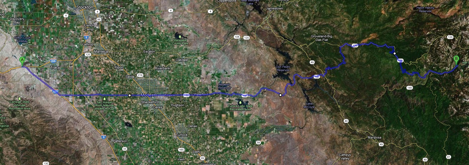
Last year I tried something similar - Bay Area over Altamont Pass, South on 580 briefly (instead of 205 through Tracy), then East on 132 to Coulterville (at Hwy 49), then 14 miles along Greeley Hill Road to 120, where you end up on 120 about 7 miles East of Groveland.
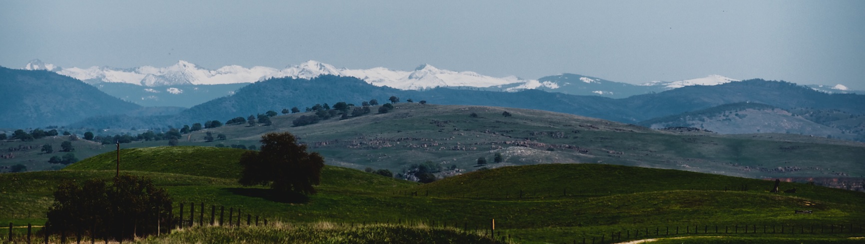
That added around 45 minutes to the faster 120 route through Oakdale; was great to get out of traffic, and rarely stuck behind a slow driver. Foothills between La Grange & 120 are a little remote, with little cell coverage. Very fun if you have a sports car driving style, and there's a pull-over-and-stop-for-a-photo view between Waterford & La Grange (2nd photo below, with Mt. Clark at left - hope for a clear day!).
Edited 1 time(s). Last edit at 01/28/2013 02:34PM by vdrummer.
January 28, 2013 03:37PM | Moderator Registered: 14 years ago Posts: 7,421 |

January 28, 2013 07:34PM | Registered: 15 years ago Posts: 4,173 |
Honestly, it's easier to spot Half Dome (and the Clark Range) from Patterson than from Denair or Turlock.
And you won't have to waste your wife's time driving around the backroads. Just pull off I-5 when you get to Patterson. Your wife could then be enjoying a latte at Starbucks while you snap photos of Half Dome and the rest of the Sierra crest.
.
And you won't have to waste your wife's time driving around the backroads. Just pull off I-5 when you get to Patterson. Your wife could then be enjoying a latte at Starbucks while you snap photos of Half Dome and the rest of the Sierra crest.
.
January 28, 2013 08:43PM | Moderator Registered: 14 years ago Posts: 7,421 |
January 29, 2013 07:43AM | Moderator Registered: 14 years ago Posts: 7,421 |
January 29, 2013 08:57AM | Registered: 15 years ago Posts: 4,173 |
January 29, 2013 01:41PM | Registered: 15 years ago Posts: 4,173 |
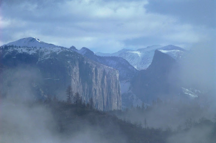
And talking about Half Dome surrounded by clouds, here's a shot I took yesterday afternoon from a bit further back than your photo.
The image is a bit soft and blurry because of a constant gusty wind that was buffeting the lens. (Once the wind died down Half Dome was obstructed by the clouds. Oh well.)

The image is a bit soft and blurry because of a constant gusty wind that was buffeting the lens. (Once the wind died down Half Dome was obstructed by the clouds. Oh well.)
January 28, 2013 08:41PM | Registered: 13 years ago Posts: 398 |

January 29, 2013 09:49PM | Registered: 15 years ago Posts: 145 |
Quote
chick-on
Awesome shot of the Clark Range.
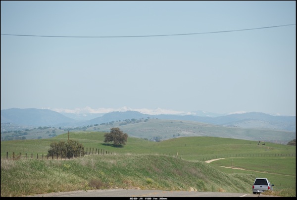
I've gone out the backroads a few times in search of the elusive Turlock shot.
Took my wife that-a-way once. She more or less said "next time you want
to take all day to get back home... make sure I'm not with you"
Thanks, Sir Chick. Did a decent amount of editing in Aperture with Nik Color EFX plug in. The original looks like this:
January 28, 2013 09:28PM | Moderator Registered: 14 years ago Posts: 1,634 |
You can bypass the Altamont by taking Patterson Pass Road. When you reach the pass you'll see a farm house down on the left and the road cut on the right. About 100 yards past the pass, almost directly across from the farm house, in the bank of the road cut will be some fossil oyster shells that are 28 million years old.Quote
vdrummer
Last year I tried something similar - Bay Area over Altamont Pass, South on 580 briefly (instead of 205 through Tracy), then East on 132 to Coulterville (at Hwy 49), then 14 miles along Greeley Hill Road to 120, where you end up on 120 about 7 miles East of Groveland.
Oh, check the route on that map. There seems to be something wrong with the Eastern portion.... unless you have 4 wheel drive.
Edited 1 time(s). Last edit at 01/28/2013 09:31PM by Dave.
January 29, 2013 05:04PM | Registered: 13 years ago Posts: 424 |
I have to agree, 132 is very pretty and a great drive. Although I did it 132 to 99 to 120 back to 205 & the altamont and on home.
On a sidenote, I did that back in October on the recommendation of my buddy who I dropped off in Coulterville. He said "You should go that way, see some new country, you have GPS right?" I reply that sure I have my iphone, I'll figure out how to get on 99 Northbound. Lucky me this is right when Apple did away with using Google maps for their maps and went their own way. Apple's directions send me into an old railyard which my phone claimed was HWY 99. I ended up just heading west and eventually hit the highway.
On a sidenote, I did that back in October on the recommendation of my buddy who I dropped off in Coulterville. He said "You should go that way, see some new country, you have GPS right?" I reply that sure I have my iphone, I'll figure out how to get on 99 Northbound. Lucky me this is right when Apple did away with using Google maps for their maps and went their own way. Apple's directions send me into an old railyard which my phone claimed was HWY 99. I ended up just heading west and eventually hit the highway.
January 27, 2013 10:30AM | Moderator Registered: 15 years ago Posts: 2,321 |
Quote
Paris92
Is there still a temporary one-lane bridge crossing the Merced River along route 140? It was near a rock slide. If so, should I expect a backup there on a Friday afternoon this time of year? Coming from the Bay Area. Enjoyed taking that route last winter, vs via 120. No traffic to speak of that time.
Two temporary (a few more years probably) one lane bridges are in place. They divert 140 traffic across the Merced River to the old railbed and back again to 140 after passing the rockslide. There is a traffic signal system that meters the east/west traffic. The maximum delay should be fifteen minutes but if traffic is light the delay will only be a couple of minutes or even no delay if you catch the light right.
This rockslide zone is expected to remain unstable for many years to come so a permanent route around it is in the process of being devised and as with everything in this area there will be countless proposals and fights over which one gets implemented.
Some video early on: http://www.nps.gov/yose/photosmultimedia/ferguson.htm
As things stand: http://www.dot.ca.gov/dist10/environmental/projects/fergusonslide/index.htm
If you can't get enough: http://gigapan.com/gigapans/4852
Old Dude
January 27, 2013 11:19AM | Registered: 13 years ago Posts: 398 |
January 27, 2013 01:33PM | Admin Registered: 15 years ago Posts: 17,050 |
January 27, 2013 02:59PM | Registered: 13 years ago Posts: 398 |
Sorry, only registered users may post in this forum.

