Welcome! Log In Create A New Profile Recent Posts
Fern on the Four Mile Trail, Yosemite National Park

The Moon is Waxing Gibbous (58% of Full)

nordvpn


Advanced

Re: Old Wawona Rd - Alder Crk. to Wawona CG

All posts are those of the individual authors and the owner of this site does not endorse them. Content should be considered opinion and not fact until verified independently.

avatar Old Wawona Rd - Alder Crk. to Wawona CG
March 06, 2013 07:54AM
This Map is quite excellent
or if you prefer
https://lh3.googleusercontent.com/-8-i37e1gCBk/UIlU8b5sHpI/AAAAAAAAAK0/QYHzZEYMRhs/s1600/WR-1920-Overlay.jpg

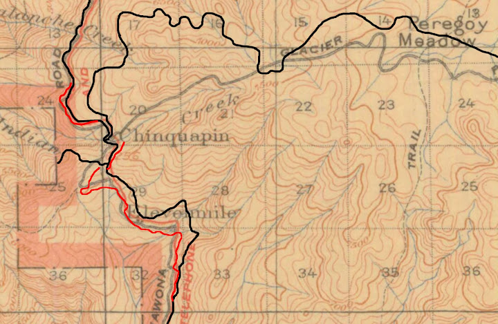
Here's the actual GPS route of the old road from where SF Merced River trail hits the old road all the
way down to Wawona Campground:

or to zoom:
https://lh4.googleusercontent.com/-a9c5xnkmllo/UTdiRCJ4ZUI/AAAAAAAACLI/YIYtY2GlKgs/s1600/OldWawona-Alder.jpg
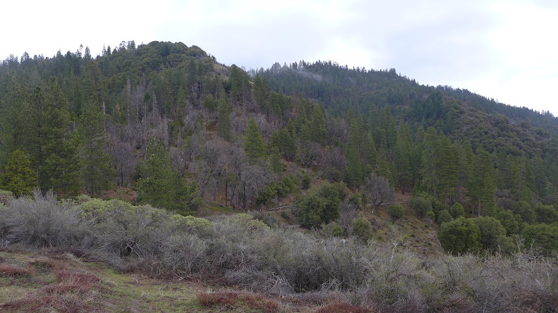
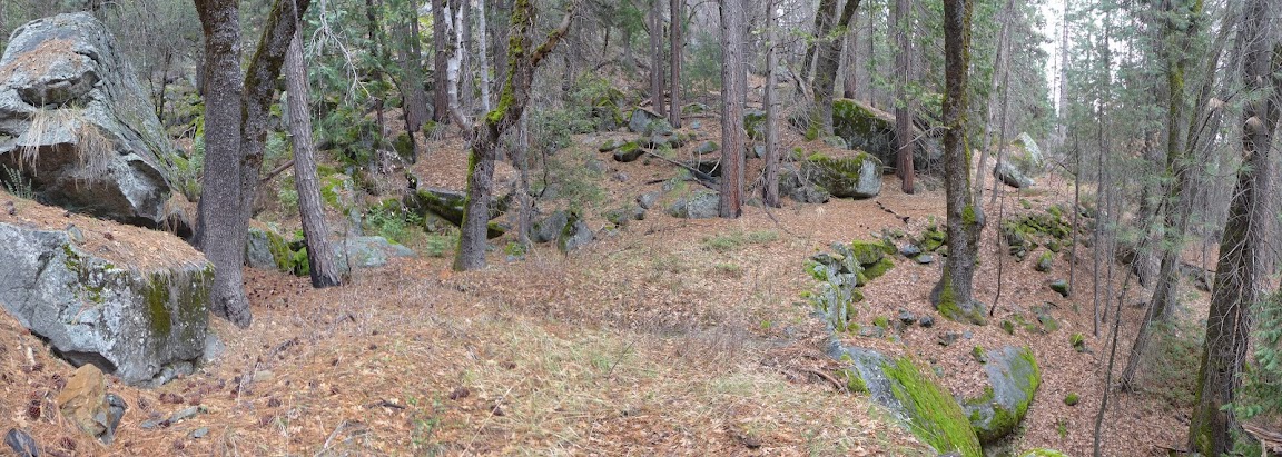
The abutment across Alder is very interesting and there is a LOT of rockwork along the way. Fairly clear sailing...
but if you look closely you'll quickly realize that I removed some of the tracks leading to the road..
As mentioned in the past... the SF Merced Trail follows the old road for a bit to the north before diving off it ... have not followed
the north section.. but with this section and it's beauty... def. it is an endeavor that must be done (well.. I gotta see it)

Take a good look at this view from the helipad along Wawona Rd:

or bigger:
https://lh4.googleusercontent.com/-rpG0OdvOPlY/UTdjErp6LII/AAAAAAAACLQ/HDw6pbbof1o/s1600/P1110554.JPG

Don't worry... I'll post some pictures of the road itself.


Chick-on is looking at you!
avatar Re: Old Wawona Rd - Alder Crk. to Wawona CG
March 06, 2013 12:01PM
Good to know that the 1920 map is reliable (btw, this is 1920 Princeton map, correct?).

I assume when overlaying the current roads, you were focusing mostly on the new Wawona Road. The reason I ask is it seems that the overlay of the current Glacier Point Road appears to be a bit misaligned with the old Glacier Point road around the vicinity of Badger Pass. (I find it interesting too that back in 1920, McGurk Meadow appeared to go by another name, Peregoy Meadow.)

Anyway, thank you very much for the photos of the old Wawona Road, but please post more!

.
avatar Re: Old Wawona Rd - Alder Crk. to Wawona CG
March 06, 2013 04:58PM
A few of the actual road:


For those that want to hike the entire length from Alder Creek... I highly recommend you take a really close look at the GPS track.
And if it wasn't obvious in the first post picture... the old road is right there... right above the new road...


Chick-on is looking at you!
avatar Re: Old Wawona Rd - Alder Crk. to Wawona CG
March 06, 2013 08:26PM
It's amazing how nice and clear the old road is in your photos.

Was most of the old road between Alder Creek and the Wawona CG in such great condition, or did you have to do some heavy duty bushwhacking (or even trail finding) on other parts of this segment of the old Wawona Road?

.
avatar Re: Old Wawona Rd - Alder Crk. to Wawona CG
March 06, 2013 11:30PM
Quote
plawrence
It's amazing how nice and clear the old road is in your photos.

Was most of the old road between Alder Creek and the Wawona CG in such great condition, or did you have to do some heavy duty bushwhacking (or even trail finding) on other parts of this segment of the old Wawona Road?

.

that is what I was wondering. If it doesn't require a whole lot of thick brush and bushwacking, then I may hike this segment of the old road sometime this summer.

fantastic pictures, thanks!!!
Re: Old Wawona Rd - Alder Crk. to Wawona CG
March 07, 2013 08:36AM
You KNOW I'm eatin' this stuff up, chick-on! hot smiley Can't post too much of this stuff for me! Would love to see some pictures of what it looks like getting to the old road from the new.
avatar Re: Old Wawona Rd - Alder Crk. to Wawona CG
March 07, 2013 10:24AM
Can't stress this enough. Gotta say something. Otherwise no more you get.

For those interested... yeah, of course... I took a zillion photos...
And since David is coo coo for Old Roads... I geotagged them... and stuffed
them up on a Picasa Album for his enjoyment.

If you really want too many photos to look at and see what a whole heck of a lot
of the road looks like... then PM me and I'll send you the link.

One thing which I'm surprised Peter didn't notice... is that there is a small little
gap in the middle of the GPS track above... well... that's because that section of
the road is no longer... and to get around it requires some daring doo of climbing
up VERY STEEP hillside. (of which I did not)
So... you want to do the hike in those 2 sections. One from Mosquito Creek.
And the other from either Wawona CG... or from a turnout about 1/2 mile south of
the helipad and zig up.
(I removed the tracks where I was poking around and also the to and fro from
the around the helipad area and then again about 1/2 mile south of the helipad)

Have fun... this road is pretty darn awesome. Yes, some bushwhack.. but very very little.
YBWMV (your bushwhacking may vary)
tongue sticking out smiley


Chick-on is looking at you!


Edited 2 time(s). Last edit at 03/07/2013 06:44PM by chick-on.
Re: Old Wawona Rd - Alder Crk. to Wawona CG
March 07, 2013 02:52PM
Awesome! I've always wondered about the OWR between Chinquapin and Wawona. Any traces of the old Alder Creek entrance station site from back when that was the south entrance to the park?
avatar Re: Old Wawona Rd - Alder Crk. to Wawona CG
March 07, 2013 06:08PM
Quote
Rob65
Awesome! I've always wondered about the OWR between Chinquapin and Wawona. Any traces of the old Alder Creek entrance station site from back when that was the south entrance to the park?

I didn't poke around too much right next to the new road.
It kinda looks like the old and new are the same at the
bend by Mosquito Creek where the buildings used to be
(according to what I see on some old maps)
These old maps can be pretty misleading w/r to the buildings.
I know I've looked around Fort Monroe many times... and
always in the wrong location... with a better map next time
hope to at least stand where the old buildings sat.


Chick-on is looking at you!
Re: Old Wawona Rd - Alder Crk. to Wawona CG
March 07, 2013 06:34PM
This is a great thread. Many thanks. It's on my to-do list....
Re: Old Wawona Rd - Alder Crk. to Wawona CG
March 07, 2013 10:42PM
Quote
chick-on
Quote
Rob65
Awesome! I've always wondered about the OWR between Chinquapin and Wawona. Any traces of the old Alder Creek entrance station site from back when that was the south entrance to the park?

I didn't poke around too much right next to the new road.
It kinda looks like the old and new are the same at the
bend by Mosquito Creek where the buildings used to be
(according to what I see on some old maps)
These old maps can be pretty misleading w/r to the buildings.
I know I've looked around Fort Monroe many times... and
always in the wrong location... with a better map next time
hope to at least stand where the old buildings sat.


I believe the old Alder Creek entrance station was moved to the Wawona NPS maintenance area in 1971. I can only hope that it is still on the premises.
avatar Re: Old Wawona Rd - Alder Crk. to Wawona CG
March 08, 2013 01:25AM
Quote
Dearborn

I believe the old Alder Creek entrance station was moved to the Wawona NPS maintenance area in 1971. I can only hope that it is still on the premises.

Hmmm. Is that near the Alder Creek Trail TH parking lot (near the campground reservations office) in Wawona?

I thought I saw an older building similar to this one in that general vicinity:

The Alder Creek Entrance Station
avatar Re: Old Wawona Rd - Alder Crk. to Wawona CG
March 08, 2013 06:58AM
Quote
Dearborn
I believe the old Alder Creek entrance station was moved to the Wawona NPS maintenance area in 1971. I can only hope that it is still on the premises.
Wow. If you are doing that from memory.

Looks like there were 3 buildings. Maybe 4.
Comfort Station
Ranger Station / Checking Station
Barn


According to Greene1987
- Checking Station was moved to 41/Mariposa Rd in 1933
- Barn was moved to Chinquapin in 1934

And directly from Yosemite Resource v3 - Greene
#2000:
Ranger office (old Alder Creek
fee collection cabin); NPS (1924);
moved to area of #4000 ca. 1934
and then to behind #4027 in 1970

#4027:
Office (old ECW office; now Wawona
district ranger headquarters)
NPS, CCC (1934)

At least that is what I see. Thanks!
Definitely looks like it is still there in Wawona. Something to look for next time.


Chick-on is looking at you!
avatar Re: Old Wawona Rd - Alder Crk. to Wawona CG
March 07, 2013 06:46PM
Quote
chick-on

One thing which I'm surprised Peter didn't notice... is that there is a small little
gap in the middle of the GPS track above... well... that's because that section of
the road is no longer... and to get around it requires some daring doo of climbing
up VERY STEEP hillside. (of which I did not)
So... you want to do the hike in those 2 sections. One from Mosquito Creek.
And the other from either Wawona CG... or by the Helipad and zig up.
(I removed the tracks where I was poking around and also the to and fro from
the helipad)

Have fun... this road is pretty darn awesome. Yes, some bushwhack.. but very very little.
YBWMV (your bushwhacking may vary)
tongue sticking out smiley


Sorry, I really didn't pay close attention to that small gap in your tracks. I would have thought it was just a blip caused by your GPS losing, temporarily, the satellite signals.

Could you post a photo of that gap, please. (I'm pretty sure you took one. wink ). I would also appreciate a link to your photo set if you don't mind. I thought you knew that I was very much interested in the old road of Yosemite too. (Though I think it might just be the four of us: you, me, David, and Wherever.)

By the way, what took out that small section of the old road? A landslide?

.
Re: Old Wawona Rd - Alder Crk. to Wawona CG
March 07, 2013 11:00PM
Me too!!White flag
Re: Old Wawona Rd - Alder Crk. to Wawona CG
March 07, 2013 11:36PM
Me tree!
avatar Re: Old Wawona Rd - Alder Crk. to Wawona CG
March 07, 2013 11:55PM
Quote
druid
Me tree!

You wood!
avatar Re: Old Wawona Rd - Alder Crk. to Wawona CG
March 08, 2013 12:30AM
knot yew?


Chick-on is looking at you!
Re: Old Wawona Rd - Alder Crk. to Wawona CG
March 08, 2013 01:00AM
Wa wona I?
avatar Re: Old Wawona Rd - Alder Crk. to Wawona CG
March 08, 2013 08:07AM
Tuol of ewe

tongue sticking out smiley


Chick-on is looking at you!
avatar Re: Old Wawona Rd - Alder Crk. to Wawona CG
March 08, 2013 07:21AM
Landslide. There's a few photos in the set.

Basilbop and Buster are also really keen on these old roads.

It's somewhat amusing to me. Put it in Backpacker magazine and I'd bet
there'd be a zillion peeps going that-a-way. I keep hearing Rockslides
due to the Backpacker article. Thing is... this road here... it's in better shape
than that road imo. Sure, it doesn't have the El Cap and views of the valley.
But it's still pretty darn kewl. I'd also bet half the ppl going up Rockslides
with their backpack come back whining or simply saying 'never gonna do that again'.


Chick-on is looking at you!
avatar Re: Old Wawona Rd - Alder Crk. to Wawona CG
March 08, 2013 07:16AM
One thing to think about is simply...
This road was completed in 1875.


Chick-on is looking at you!
avatar Re: Old Wawona Rd - Alder Crk. to Wawona CG
March 11, 2013 07:52AM
Just an incredible work to piece together the history of the Old Wawona Road can be found
here --> HAER History of The Old Wawona Road

All the credit goes to DavidK42 for finding that!

Myself... I have to admit... I'm more apt to just look at a map and go explore rather than read.
If you read the above link... there's a lot to be learned. Just great stuff.

Thanks!


Chick-on is looking at you!
Re: Old Wawona Rd - Alder Crk. to Wawona CG
March 11, 2013 09:00AM
Quote
chick-on
Just an incredible work to piece together the history of the Old Wawona Road can be found
here --> HAER History of The Old Wawona Road
Yes, those HAER reports are fascinating reading for fans of the old roads. They have a handful of cool old photos, as well. For example, here's the old road peeling off towards Eleven Mile Station:


I also stumbled across these other very cool old photos on my computer...I'd completely forgotten about these and, in fact, need to do a bit of research to figure out the actual websites where I pulled them.
An unidentified changing station along the OWR:


A particularly precarious stretch of the OWR:


Winter on the OWR:


Quote
chick-on
Myself... I have to admit... I'm more apt to just look at a map and go explore rather than read.
If you read the above link... there's a lot to be learned. Just great stuff.

Oh sure...rub it in! Some of us HAVE to resort to reading about it (at least for most of each year!) tongue sticking out smiley
avatar Re: Old Wawona Rd - Alder Crk. to Wawona CG
March 11, 2013 05:30PM
Quote
DavidK42
Quote
chick-on
Myself... I have to admit... I'm more apt to just look at a map and go explore rather than read.
If you read the above link... there's a lot to be learned. Just great stuff.

Oh sure...rub it in! Some of us HAVE to resort to reading about it (at least for most of each year!) tongue sticking out smiley

Love the old photos! Send a link if you have one. I haven't run across those.

I didn't mean to rub anything in. Moreso I was poking fun at myself for my "research" consisting
of playing around with maps and looking at pictures and not doing much reading.

The account of the old road makes it sound like the section between Alder and Bishop may not be
quite as nice as the overlay map makes it out to be. We shall see. The only thing I know at this
point is that the SF Merced Trail follows the old road for a bit and then dives off it... the section
of road to the north of the trail looked like a Manzanita Jungle. But you never know. It may be like
that for 10 ft. or ... yum.


Chick-on is looking at you!
Re: Old Wawona Rd - Alder Crk. to Wawona CG
March 11, 2013 07:12PM
Quote
chick-on
I didn't mean to rub anything in. Moreso I was poking fun at myself for my "research" consisting
of playing around with maps and looking at pictures and not doing much reading.

I absolutely know that, my friend...you're my eyes and ears on the ground until I can get my butt relocated to within a few hours of Yosemite (even then, you'll probably STILL be getting to places I can't make it to!) Smiling dogpile
Re: Old Wawona Rd - Alder Crk. to Wawona CG
March 11, 2013 07:41PM
Quote
DavidK42
An unidentified changing station along the OWR:

SO, historical detectives, anybody want to venture a guess as to WHICH changing station this is? In the post above, I identified it as being along the OWR but, looking again, I can't swear that it isn't one of the other old roads. If it is the OWR, I'd be totally guessing as to which of them it was.

For that matter, I'm not certain the 3rd photo's along the OWR either. The background is very washed out but it looks like it might be the lower Merced River Canyon which would could make this the stretch of the OBOFR a little way beyond Rainbow View where the road bears right and leaves the edge of the canyon. I'll have to pull out some of my photos of that stretch of the road as it is now and see if I can piece it up with that.Anybody have thoughts on either of these.
Re: Old Wawona Rd - Alder Crk. to Wawona CG
March 13, 2013 11:37PM
No idea on the whereabouts of this photo, but the third photo (the "precarious" one) might be along the stretch of the OWR north of Grouse Creek where it makes a steep climb up toward Turtleback Dome and, eventually, Fort Monroe.
avatar Re: Old Wawona Rd - Alder Crk. to Wawona CG
March 14, 2013 08:15AM
Missed this post. I dunno. The canyon there looks like SF Merced.
(thanks David... now this is something I'd waste time on)


Chick-on is looking at you!
Re: Old Wawona Rd - Alder Crk. to Wawona CG
March 11, 2013 06:28PM
Great reading. Thanks for posting.
Re: Old Wawona Rd - Alder Crk. to Wawona CG
March 11, 2013 06:27PM
Wow this stuff is amazing. The last picture in David K42's series in particular knocks me out. Look at the flow of the waterfall.

I'm also struck by how quickly the old road seems to be being recaptured by nature.


Edited 1 time(s). Last edit at 03/11/2013 06:29PM by hegel.
avatar Re: Old Wawona Rd - Alder Crk. to Wawona CG
March 11, 2013 07:45PM
Quote
hegel
Wow this stuff is amazing. The last picture in David K42's series in particular knocks me out. Look at the flow of the waterfall.

I'm also struck by how quickly the old road seems to be being recaptured by nature.
One thing you have to realize is that many of the old photos are taken with a very long exposure.
Long exposure = exagerated flow in the falls typically.

Interesting comment w/r to be recaptured. I have the nearly opposite feeling. I'm just amazed at
just how good of shape many of these old roads are in. Even more amazed at just how nice the
rockwork on the roads are. For me it's makes hiking the old roads so interesting.
These are far from your typical NF road out in the woods.


Chick-on is looking at you!
avatar Re: Old Wawona Rd - Alder Crk. to Wawona CG
March 11, 2013 10:31PM
Quote
hegel

Wow this stuff is amazing. The last picture in David K42's series in particular knocks me out. Look at the flow of the waterfall.

Nice, but the flow wasn't as great as this one:
Re: Old Wawona Rd - Alder Crk. to Wawona CG
March 11, 2013 07:00PM
WARNING: The following message could be harmful to your schedule! smiling bouncing smiley

The first one is from the HAER report you mentioned but your link goes to the Wikisource summary of it. You need to find the Library of Congress page for the original publication which includes a bunch of photos.

Next two are part of the massive collection of the Online Archive of California. There are lots of sub-collections there but two especially nice ones are the San Joaquin Valley & Sierra Foothills Photo Heritage collection and the Views of Calaveras and Mariposa Counties, California, 1890 collection which only has about a dozen Yosemite shots but they're very nice (and are the source of the two photos above). BTW, all these links include filters to pick out the Yosemite items but there's a lot of other great material in the collections as well.

The last one is from a 1926 publication called Lights and Shadows of Yosemite. The picture itself is near the bottom of this page. This last one is posted at the fabulous Yosemite Online Library which has been mentioned in this forum in the past but for anyone who's NOT seen it, well, let's just say that your schedule is REALLY screwed now! Rolling on floor laugh


Edited 1 time(s). Last edit at 03/11/2013 07:03PM by DavidK42.
Re: Old Wawona Rd - Alder Crk. to Wawona CG
March 11, 2013 07:31PM
And as long as I'm pointing to the HAER reports for all my fellow old road junkies, there are also HAER reports about the Tioga, Big Oak Flat and Coulterville roads:

Big Oak Flat Road (aka HAER No.CA-147) in easily readable Wikisource form or the Library of Congress version with pictures.

Tioga Road (CA-149) is at Wikisource or Library of Congress.

and the Coulterville Road (CA-146) at the Library of Congress (for some reason, Wikisource doesn't seem to have this one).

Just repeating from above but, in order to keep all four of the principal old roads together in one message:

Wawona Road is at Wikisource and Library of Congress
Re: Old Wawona Rd - Alder Crk. to Wawona CG
March 11, 2013 07:34PM
Thanks for the sources.
Re: Old Wawona Rd - Alder Crk. to Wawona CG
March 12, 2013 08:09PM
chick-on: good point about exposure time on the old photos. I hadn't thought about that.

As to the recapturing of the old roads: I was thinking that the wilderness was coming back in her own terms; liesurely, assuredly, where a hundred years is the equivelent of our just getting up out of bed. You can see the mat of leaves covering the road; the beginnings of bushes; trees fallen across the road; rockfall; etc.

There must be something between Geologic time, which is ridiculously large and expansive, and human time, which is notoriously brief. Maybe Nature's time, which we can comprehend but which is longer and slower than our own.

Over the last twenty years or so I've been watching the trees around Echo Valley grow in recovery from a fire that I never witnesssed. In those years I've marked their slow growth. I'll never live to see this new forest develop into adolescence, much less maturity. At the moment they're no more than a crowded stand of small trees that deer take refuge in at dusk. In my imagination I can picture a not too distant stand of stately Cedar and Jeffrey Pine in this area, but who knows? There are other fires to come. I'm glad I've been able to see what I've seen.
avatar Re: Old Wawona Rd - Alder Crk. to Wawona CG
March 12, 2013 08:36PM
hegel, well said
we're just visitors on this planet... and we'll all be gone...
humanity and all in a blink of the cosmic eye
enjoy your time and make it lasting


Chick-on is looking at you!
Re: Old Wawona Rd - Alder Crk. to Wawona CG
March 12, 2013 09:35PM
I remember going to Yellowstone after the big fire and seeing the tiny grasses and pine trees break their way through the soil. Each trip that we have gone back we stop in the same place to look at the changes and they are amazing. Now those tiny seedlings are over ten feet tall and are crowded together. There are still burnt trees standing and when the wind blows you can hear them creaking. It is a amazing experience being surrounded by all these young trees and see the old trees, now with the burnt bark off , swaying like silver ghosts in the wind. In the years to come the new trees will grow and shade the ground and a succession of plant types will come and go. I have waymarked the spot on my GPS so we will find the area even if it is many years between trips so we can go back and see the changes.
Re: Old Wawona Rd - Alder Crk. to Wawona CG
March 13, 2013 12:24AM
When I moved from Merced/Stanislaus Counties to Yellowstone in 1974, the first thing I noticed was the impossibly thick Lodgepole Pine forests in Yellowstone. I thought that WHEN a fire starts in that vegetation, there will be a firestorm that makes its own weather. The summer of 1988 was virtually unparalleled in its intensity and the standing dead wood was drier than kiln-dried lumber! I saw streetlights coming on in Cody - 50 miles from the fire - at 2:00 in the afternoon and scorched pine needles were deposited in Cody by the wind (glad they weren't burning!). As a former Yellowstone employee, I received a more than generous helping of scorn for allowing the fires to burn. Actually, Yellowstone was in full fire suppression a month before they publicly admitted it, but several of the fires reached 1,000 acres - in their first hour! Several subsequent large fires in the northern Rockies have taught the residents that the September equinox storms actually extinguish the huge fires - and not mortal man. At the time, I vacationed in Yosemite with my wife and young children and I brought along some pictorial publications on the 88 Yellowstone Fire for Yosemite friends. Little did we know that Yosemite was going to experience its own firestorm in the summer of 1990. My family and I were evacuated early in the day from Lower River campground, with the evacuations starting at the eastern most Valley campgrounds and moving west as the morning progressed. As we drove down the Arch Rock Road, there were smoldering fires within 3-4' of the roadway that would soon flare up with the heat of the day. A lof of thought went into that evacuation and I still commend the people who pulled it off. A final observation on the Yellowstone Fires of '88: I visited a fire camp on a day off and one of my colleagues pointed out the old twisted trees on the ridge tops. He said those were the trees that survived the last big fire some 300+ years before.


Edited 1 time(s). Last edit at 03/13/2013 12:26AM by Dearborn.
avatar Re: Old Wawona Rd - Alder Crk. to Wawona CG
March 13, 2013 03:30AM
it is amazing the effects that fires have on the land
avatar Re: Old Wawona Rd - Alder Crk. to Wawona CG
April 23, 2013 07:50AM
Been finding and hiking bits and portions of this road off and on this year due
to the ridiculously low amount of snow at lower elevations. I'd like to hear from
anyone who has found sections other than what is marked on these maps.
(only thing I know for certain is that there is a section S of Grouse abutment...
just haven't taken time to look there yet)
(and the section N of Grouse is fairly ... hehehe... simple to follow)

Some sections N of Alder:


Sections around Chinquapin:


Also been hiking and finding bits and portions of Yosemite Lumber RR lines.
Some of those are just great fun to locate... uh.. I mean.. thrash thru.

Have fun


Chick-on is looking at you!
Re: Old Wawona Rd - Alder Crk. to Wawona CG
April 23, 2013 11:36AM
So do you think the piece you show as being east of the current WR between the Henness Ridge Road junction and Indian Creek is part of the Old WR? I had wondered, but other map overlays on another thread here seemed to show that the Old WR is somewhere to the west of the current WR all the way to Chinquapin (which didn't make sense to me given the topography -- such a road would have had to lose a lot of elevation before climbing back up to Chinquapin -- assuming that the old Chinquapin junction was in the same location as the current junction (has this been confirmed?). Your track stops right at Indian Creek -- what happens between there and Chinquapin?
avatar Re: Old Wawona Rd - Alder Crk. to Wawona CG
April 23, 2013 04:50PM
Quote
Rob65
So do you think the piece you show as being east of the current WR between the Henness Ridge Road junction and Indian Creek is part of the Old WR? I had wondered, but other map overlays on another thread here seemed to show that the Old WR is somewhere to the west of the current WR all the way to Chinquapin (which didn't make sense to me given the topography -- such a road would have had to lose a lot of elevation before climbing back up to Chinquapin -- assuming that the old Chinquapin junction was in the same location as the current junction (has this been confirmed?). Your track stops right at Indian Creek -- what happens between there and Chinquapin?
I'm not sure. But it is w/o question an old road with old telegraph wire on it. It seemingly just stops where I drew it. I couldn't find any abutment over Indian Creek
and it's very steep on the other side (north) of Indian. I put it in in case anyone wanted to go explore more. To the north of Henness which goes to Yosemite West and to the west of
New Wawona Rd. I could not find anything that was remotely looking like a road to me. There was snow at Indian so I MAY have seen some sort of abutment but wasn't entirely sure.
Definitely did not find anything looking like a road... so either they obliterated the road there... or it is indeed actually east of New Wawona. The old map certainly doesn't show it there
so just confused. When you find sections of these old roads they are pretty hard to not follow and say with certainty 'this is it'. That is certainly the case N of Chinquapin and all the
other sections I have drawn in. This really leads me to lean towards that it is Old Wawona and the 90 degree left turn I somehow missed. Needs more exploring.
(anyone doing so will enjoy it) (by enjoy I mean... climbing over and under some huge downfall and whatnot)


Chick-on is looking at you!
avatar Re: Old Wawona Rd - Alder Crk. to Wawona CG
April 23, 2013 05:10PM
This is the Indian west of New Wawona. It appears that maybe there is some rock work there....

It was hard to tell... and enough snow and water to just come back again with less...


Chick-on is looking at you!
Sorry, only registered users may post in this forum.

Click here to login