The very juicy thread (well, juicy to at least 3 or 4 of us on this list!) that chick-on recently started about the old Wawona Road between the CG and Alder Creek got me thinking about an even older route through that area:
Various people (including me) have mentioned this trail here in the past. It was the route from Wawona to the Valley before the old Wawona Road was built. Unless I'm forgetting something on some of the particularly old maps I have around here, I've never seen it specifically called out on maps but, from the descriptions I've read, it would seem to have been at least partly along the lines of what we now call the Alder Creek trail. Any of my other old-road/trail-junky brethren here know anything specific about this? Searching the forum, the only hits I found were something I posted a couple of years ago (and, more indirectly, here). I think there was an earlier alignment of the Pohono Trail (which went out to the vicinity of Fort Monroe before turning to go out towards GP and that this may have been part of the remains of this old Mann Brothers route as well.
I'll do a bit more research when I have a little more time but I wanted to start this thread while it was on my mind.
All posts are those of the individual authors and the owner
of this site does not endorse them. Content should be considered opinion
and not fact until verified independently.
|
Mann Brothers trail to the Valley March 08, 2013 12:18PM | Registered: 13 years ago Posts: 617 |
March 08, 2013 12:48PM | Registered: 15 years ago Posts: 4,173 |
March 10, 2013 06:46PM | Moderator Registered: 14 years ago Posts: 7,421 |
The links to the Old Wawona Road and Old Big Oak Flat Road were SO good.
Just excellent.
I've seen the old Mariposa trail and Mono trail, etc. on very old maps by Hoffmann...
So I took that and placed it onto a 1906 map... and got this:
It's pretty amazing that the very very crude map of Hoffmann is actually as good as
it is and am able to get it anywhere close to being a believable route.
Prehaps more on this later.
Here's the map:
(red are the old trails) (blue is Alder Creek, Merced, SF Merced)
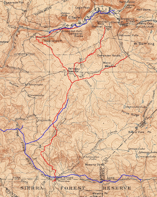
https://lh4.googleusercontent.com/-_Mnnfk9VLPg/UT02q-U3JLI/AAAAAAAACQE/tNJ7doU0zPM/s1600/MannsTrail-HoffmanOn1906.jpg
Unless rock work was done trails are nearly impossible to make out (is that a man made trail or game trail)

Just excellent.
I've seen the old Mariposa trail and Mono trail, etc. on very old maps by Hoffmann...
So I took that and placed it onto a 1906 map... and got this:
It's pretty amazing that the very very crude map of Hoffmann is actually as good as
it is and am able to get it anywhere close to being a believable route.
Prehaps more on this later.
Here's the map:
(red are the old trails) (blue is Alder Creek, Merced, SF Merced)
https://lh4.googleusercontent.com/-_Mnnfk9VLPg/UT02q-U3JLI/AAAAAAAACQE/tNJ7doU0zPM/s1600/MannsTrail-HoffmanOn1906.jpg
Unless rock work was done trails are nearly impossible to make out (is that a man made trail or game trail)
|
Re: Mann Brothers trail to the Valley March 10, 2013 07:39PM | Registered: 13 years ago Posts: 617 |
Quote
chick-on
I've seen the old Mariposa trail and Mono trail, etc. on very old maps by Hoffmann...
So I took that and placed it onto a 1906 map... and got this:
First off, thank you (yet again!
 ) for the overlay map! I don't think I've seen these Hoffmann maps you mention, though. Did you find them online somewhere?
March 11, 2013 07:46AM | Moderator Registered: 14 years ago Posts: 7,421 |
Quote
DavidK42
I don't think I've seen these Hoffmann maps you mention, though. Did you find them online somewhere?
David Rumsey has an excellent collection
And you can download them in super high defintion by creating userid and login
David Rumsey Yosemite Map Collection
So 3 great sources for old maps
Princeton (THE best Yosemite Valley Maps... period)
David Rumsey
USGS
USGS and David Rumsey have many of the same
Need to try again to see if can purchase a few of the Princeton Maps.
They are just that good. Wondering if Yosemite Research Library has them....
March 10, 2013 10:13PM | Registered: 15 years ago Posts: 4,173 |
Thank you for the overlay.
So do you think the current Alder Creek Trail is not the same as the old Mann Brothers trail? And besides rock work, could there still be some blazes on trees from the old Mann Brothers trail (or is it more likely those trees are now long gone)?
Edited 1 time(s). Last edit at 03/11/2013 01:16AM by plawrence.
March 11, 2013 07:38AM | Moderator Registered: 14 years ago Posts: 7,421 |
Quote
plawrence
Thank you for the overlay.
So do you think the current Alder Creek Trail is not the same as the old Mann Brothers trail? And besides rock work, could there still be some blazes on trees from the old Mann Brothers trail (or is it more likely those trees are now long gone)?
Same trail? Perhaps most is... but even the current trail doesn't align entirely with a modern Topo Map.
It's been moved in at least one area. Add to that that a large portion of the area has been logged and
a number of rail lines put in.. and certainly any original blazes are long gone along with the trees they
were on. Regardless, more or less, the route is basically the same. The path of least resistance
usually is the way they went.
All this is pretty much my take on things so take it as you wish.
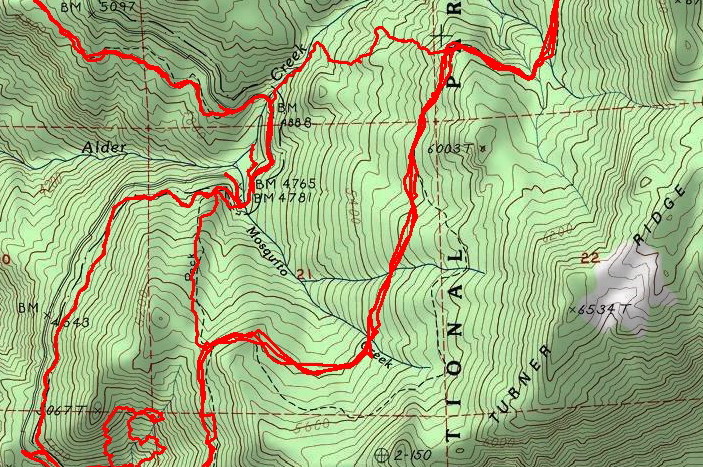
Here's the logged lands map I made:

March 11, 2013 07:41AM | Moderator Registered: 14 years ago Posts: 7,421 |
March 11, 2013 10:15AM | Registered: 15 years ago Posts: 4,173 |
March 11, 2013 05:23PM | Moderator Registered: 14 years ago Posts: 7,421 |
The trail zigs off the old railroad line at the north there where the gps tracks and dotted trail diverge.Quote
plawrence
BTW, have you ever hiked x-country to the top of the Turner Ridge shown on your map? Looks like taking the abandon trail would lead you halfway up to the top of the ridge.
Have not followed the old railroad bed south of there yet... that along with a complete
Turner Ridge traverse have been on the list o things to do for a few years now... eventually will do it...
only been on the ridge west of Turner Meadow... it's nice. really nice. But then again I'm easily amused by
open ridges and exfoliating granite.

March 11, 2013 10:14PM | Registered: 15 years ago Posts: 4,173 |
March 12, 2013 12:10PM | Moderator Registered: 14 years ago Posts: 7,421 |
To complete the picture (or make it more muddled) (or just make you cry)
Here's more of Hoffmann Survey Map on 1906 map including the Trail to Mono.

https://lh3.googleusercontent.com/-Szob-r5Krug/UT98vVMG31I/AAAAAAAACRw/mPlKfO1x5Dk/s1600/MonoTrail.jpg
Here's more of Hoffmann Survey Map on 1906 map including the Trail to Mono.
https://lh3.googleusercontent.com/-Szob-r5Krug/UT98vVMG31I/AAAAAAAACRw/mPlKfO1x5Dk/s1600/MonoTrail.jpg
March 12, 2013 12:22PM | Registered: 15 years ago Posts: 4,173 |
March 12, 2013 02:48PM | Moderator Registered: 14 years ago Posts: 7,421 |
Much better maps and write-up can be found here w/r to the "Trail to Mono"
http://yosemitenews.info/forum/read.php?3,58253,58253#msg-58253
http://yosemitenews.info/forum/read.php?3,58253,58253#msg-58253
Sorry, only registered users may post in this forum.

