http://yosemitenews.info/forum/read.php?3,57870,57870#msg-57870
http://yosemitenews.info/forum/read.php?3,42174,42257#msg-42257
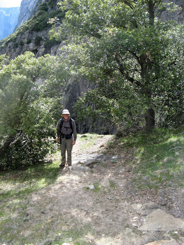
My memory of the place was tainted by the fact that my previous trek up there was with my two (then) high school daughters, whose hiking shoes were more like sneakers. All I can remember from that hike was my constant worry that they would slide too much on the loose dirt and go over the edge. This trip offered a good chance to reset my calibration on how risky or not the place really is....
Although the west end of the bench is a fine sunny flat ledge, most of the ledge is 50 to 100 feet wide covered with steep dirt at the critical angle, mixed with loose rocks. In that respect it is like a lot of the stuff in Utah or the Grand Canyon. Fortunately, most of it is also covered with trees and bushes, and the use trail does not feel exposed, except in a few places. The climbers guide lists it as class 2+, with one interesting spot. That spot occurs early on, where the trail is along the upper part of the ledge and crosses a stream bed using an easy ledge walk along the upper cliff face. Except for exactly one place, where a bulge at stomach level puts you almost off balance, and the hand holds are uncomfortably low for a tall guy like me. My buddy went through there without blinking, and I would have done so, too, in 1960. While going in either direction I stretched up and then squatted down and hemmed and hawed a few times before proceeding. I did notice that the deer simply went fifty feet down a steep dirt bank, crossed the gully, and went fifty feet back up steep dirt on the other side. With beginners and a hand line, that route might be faster than talking them past the tricky spot...
The usual problem with finding Sunnyside Bench, if you haven't been there, is finding the entry to the ledge. We did it by starting up the Indian Canyon Trail (see http://yosemitenews.info/forum/read.php?3,49133), because we are enamored of its fine switchbacks and stonework, but it is easy to get too high and to be cut off by stone buttresses coming down from Yosemite Spires. In the photo below, I am showing the GPS track from our descent, which is more like the usual route:

The photo has two X's and three arrows. The route starts alongside the government horse pens in the northwest corner of the service compound in Yosemite Village. A good trail along its fence will take you to the paved northside hiking trail (first arrow). Follow the trail until you pass the only long talus scar in this region (second arrow). Turn left and go up the hill until you pass the end of the talus scar, then head up to the left. If you continue too far straight up, you will miss the turn-off and have to come back down to the ledge's entry point. Some people prefer to go up on the talus, or up in the woods along its west edge, but coming down it seemed to us that the east edge in the trees was easier.
The third arrow marks the interesting place. The X at the west end marks the apparent end of the bench. However, if you step up to the cliff face, you will find that some nice soul has cut a perfect trail behind a dense row of manzanitas that takes you around a corner to a pair of splendid overlooks of Middle Yosemite Falls and the lip of Lower Yosemite Falls.
Note that when Google Earth pastes a GPS trace onto a steep bit of terrain, any slight disagreements about GPS coordinates will cause the track to veer up and down the hill. Here is the same track as the Delorme unit saw it:

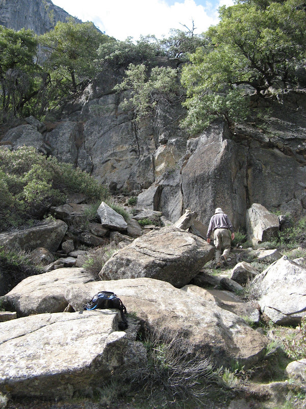
That bump two thirds of the way along the ledge, where you climb up to the cliff face and then back down to the lower lip, is real. That's what the use trail does, maybe to avoid some brush or some nasty loose stuff. Here is what it looks like when you do get down after that detour:

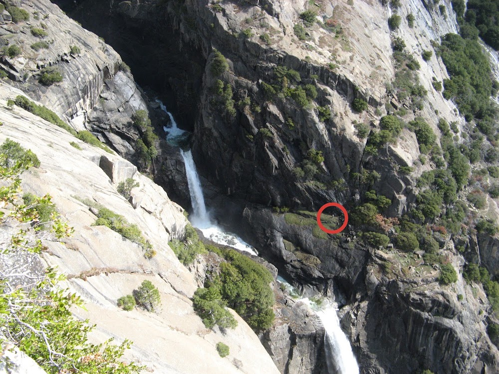
The use trail doesn't go as close to the edge as where the photographer was standing to get this view. But the bush marked X will be mentioned again.
And the end of the bench is the splendid place marked on both maps. There is a fine tree that you can lean out on and look down at the tourists on the bridge below the lower falls. John Muir napped here.
Looking back, you get a good view of Half Dome, etc, and the storm coming in from the southeast. Sorry about the overexposed foreground...

Looking uphill, you see the start of the class 3+ hike up to Fern Ledge, the Lost Arrow, and the Upper Falls area. My buddy went up there a ways, but it's not for me. Hidden behind that bush in the middle left is the hacked-out trail to the lookouts above the lip of the Lower Falls. Unfortunately, the spray there from the Middle Falls was enough to keep our cameras under wraps.
As the drizzle began, we made our way back to Yosemite Village, where my buddy discovered that his wife's camera was no longer attached to his belt. It was decided that he would go back in the morning to look for it, while I went up the Falls trail to the pipe railing at Oh My Gosh Point to get some photos.

The X shows the flat spot at the end of the main trail, as mentioned above. A trail behind the bushes takes you to the pair of lookouts.
Here is our man looking for his camera at the middle falls lookout. No camera.
And at the lower falls lookout. No camera.

Then up towards Fern Ledge. Here is an easy friction bit above the "more interesting" spot:

And on up to the edge of the area wet with spray. Nice view, no camera.

Actually, the camera was in that bush mentioned earlier. He found it while on his way back. By afternoon, the poor weather had returned, and my afternoon hike was aborted by light rain, light hail, and lightning as I approached Union Point.
There was some comment earlier on this forum to the effect that Sunnyside Bench is dangerous, and that a number of people had died there. Well, it is obviously hazardous. Don't go up there on my say-so. But that reference made to the book "Death in Yosemite" isn't quite accurate. In the chapter with the list of deaths while scrambling around (not actually rock climbing), Sunnyside Bench is mentioned a dozen times. But that seems to be a reference to the whole area beneath Yosemite Point. Six of those people died above the ledge (three of them after having crossed over from the Yosemite Falls Trail and maybe falling while route-finding down from Fern Ledge). Another three died below the bench while scrambling around on the slabs of the Sunnyside Bench Climb, which starts way down by the tourist area at the base of the lower falls. Of the remaining three, one was fooling around in the dark, and the other two might have been on the down-climb from the aforementioned rock climbing route....the text is unclear. None of these death reports mentions walking along the ledge, though it's possible that the latter two people were doing so. But more likely not. A one sentence citation doesn't leave much room for precision, especially if you never distinguish between Sunnyside Bench and a popular climb with the same name...
On Friday, we had to leave by one o'clock. So we hiked up to Hidden Falls and on the abandoned trail to the base of Snow Creek Falls. The Hidden Falls hike has been covered elsewhere.
http://yosemitenews.info/forum/read.php?3,63839,64687#msg-64687
http://yosemitenews.info/forum/read.php?3,64500,64523#msg-64523
Its use trail starts at the southeast end of the bridge that is the farthest point on the Mirror Lake loop trail. The distance off the main trail is less than a half mile, but the use trail is wiped out in a few places by old snow avalanche tracks and such. The use trail runs close to the bank of the creek, so it's impossible to get very lost. If you lose the trail, look for it near the river.
Right now, Tenaya Creek is running full, and the huge boulders around the falls are wet and greasy-feeling from the spray. Unlike my comment about Sunnyside Bench, the book does mention someone who slipped near here and died. That situation applies to almost any river area in the park. Be careful. This is a lovely little falls.
The old trail to Snow Creek Falls starts at the northwest end of the same bridge. From the bridge approach you can see a bit of stonework where it starts . The old trail follows along the bank of Tenaya Creek until it hits Snow Creek, then follows along that creek until it appears to end at the lip of a normally dry overflow channel. But the trail is just washed out. After a bit of boulder scrambling, you will see a few stone steps going on to the edge of the forest at the cliff base.
At this point, the falls are more of a cascade:

The banks of this creek are a lot steeper than they appear in the photo, and are not an attractive scramble. Nearby is an uncommon view of the overhung belly of Basket Dome, with the Snow Creek Trail passing diagonally upward somewhere across the middle of the view:

This old trail is much shorter than the one to Hidden Falls. Maybe a quarter mile of easy going, except for some rocks at the very end. Another perfect beginner bushwhack.
Edited 1 time(s). Last edit at 04/05/2013 11:14AM by wherever.

