Welcome! Log In Create A New Profile Recent Posts
Deer in Yosemite

The Moon is Waxing Gibbous (84% of Full)


Advanced

Re: Moonlight Rock on the old Mariposa Trail (long)

All posts are those of the individual authors and the owner of this site does not endorse them. Content should be considered opinion and not fact until verified independently.

Moonlight Rock on the old Mariposa Trail (long)
April 21, 2013 02:01AM
OK, this post won't be very interesting unless you like to read about the abandoned old roads and trails in Yosemite Park. We have been hiking around, tracing a bunch of the old routes. These include the old Mono Trail, the Old Big Oak Flat Road, the Old Wawona Road, the Mariposa Trail, etc. This post will make a lot more sense if you have previously read the comments about famous old viewpoints along the south rim. see

http://yosemitenews.info/forum/read.php?3,48350

Anyway, I was up there this week with three grade-school-age grandkids. Not a good trip for doing rough bushwhacking, but the kids were more than happy with Oh My Gosh Point (on the Yosemite Falls Trail), and with the long loop trail around Mirror Lake. And they did the wonderful kids' hike from Tunnel View up to (new) Inspiration Point, then down the abandoned old road along the top of the cliff above the tunnel and onward to the base of Bridalveil Falls.

But, of course, I couldn't avoid poking into a bit of history. There is a new book at our library, called "The Inventor and the Tycoon: A Gilded Age Murder and the Birth of Moving Pictures", about Leland Stanford and Eadweard Muybridge. Muybridge was an interesting character, crackpot, photographer, and murderer. He killed his wife's lover, and got off partly on an argument of insanity, the evidence for which was partly based on photos of him on the cliffs of Yosemite.

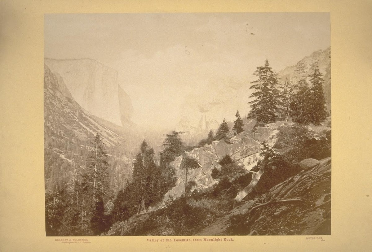
He was also the first to take a large plate camera to the valley. He got some great photos. In 1872, he took a photo from Moonlight Rock that was widely circulated:
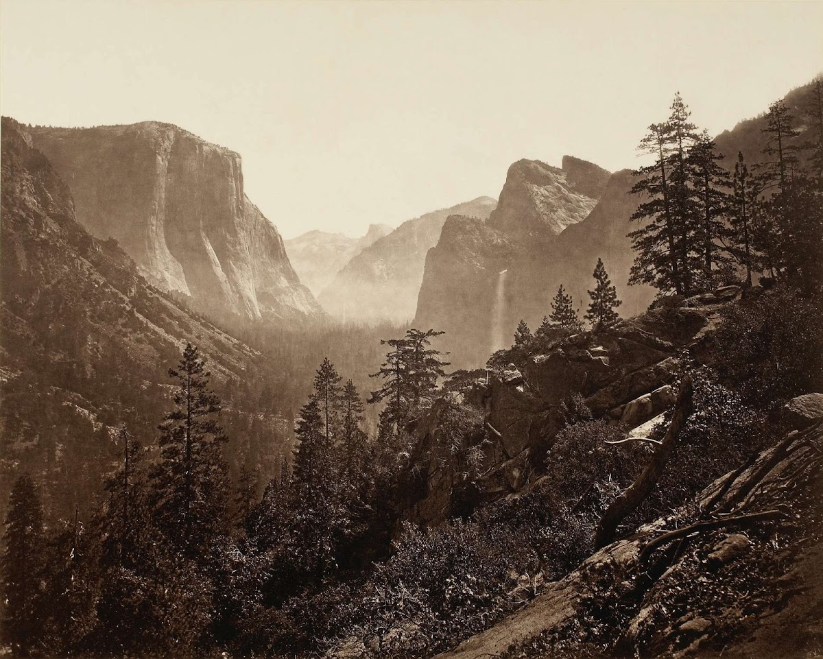


Unfortunately, photographic emulsions of the time were mostly blue-sensitive, which accentuates the haze. Thus, Sentinel Rock is essentially invisible in the above photo, but it is actually in the scene...

The view looks familiar, right? Moonlight Rock must be somewhere near Inspiration Point. It also must be near the Mariposa Trail. The reason for this is in the timing. There were no roads into the valley in 1872. Two years later, you would have seen the Old Big Oak Flat Road being built across that talus pile over towards El Capitan. A year after that, the wagon road from Wawona to the valley was completed, and you could have taken a photo from New Inspiration Point. But in 1872, there was only the mule trail that came down through Meadow Brook meadow to the valley rim, then down past Old Inspiration Point and all those other named points mentioned in that first link above.

Large plate photography was a big deal in those days, because the cameras were huge. You had to make the photographic emulsion on the spot and coat the glass plate with it in a light-proof tent immediately before making the exposure. So you needed mules, even more than Hill needed them for his easel and canvas. Wherever Moonlight Rock is, it must be next to the old Mariposa Trail.

One way that these places got named was by the muleteers, who were the tour guides of the day. It was important that the tourists thought that you took them to all the best places, so the guides named everything along the route. Hence, today's Inspiration Point is where it is because the previous one was on the Mariposa mule trail, not on the Wawona Road. When the road was built, it didn't go by the original Inspiration Point, so they named a new one where the road touched the old trail. By that reasoning, the name should have been moved again when the newest road and tunnel was built in 1933. But too many people had now been to the previous Inspiration Point, so they had to name the new place "Discovery View", i.e. "Tunnel View and parking lot". Artist Point is another example. There is no point there, at least not along the road where the name is applied....

Anyway, Moonlight Rock must be some lookout point in that vicinity, accessible before either road was built.

If you look at the old maps, they consistently show the Mariposa Trail coming down the ridge to New Inspiration Point, then continuing northeast down the hill to the bank of the Merced near the Pohono Bridge. The Old Wawona Road has some switchbacks below Inspiration Point, then crosses the old trail and descends at a uniform grade straight to the Bridalveil parking lot. The new Wawona Road and tunnel do the same thing, but at a lower elevation and a less steep grade. There was a period when the foot trail was bent west to hit Fort Monroe, when it was the entry station to the park, but after that ceased to be true it reverted to the older route, now called the Pohono Trail.

In 1893, the USGS issued a version of the 1883 Wheeler map with the roads highlighted in red, as an attachment for some Yosemite legislation:


In that map, courtesy of the Rumsey collection, the Mariposa Trail is clearly seen to touch the road at (new) Inspiration Point, then continue down to the valley at a steeper pitch than the road. The trail, which was based on the old Indian route, would not want to cross Artist Creek or Meadow Brook while traversing a steep hillside. It would just go directly down the hill. The trail itself was famously steep, according to writings of the tourists on muleback. The map above predates the period when the trail was re-routed over to Fort Monroe and down the road to the valley.

Here is a 1910 map, courtesy of Chick-on, showing that later route. Coming down the trail (now called the Pohono Trail) you were expected to hike on the road from Fort Monroe down to the valley, if you didn't have a horse to carry you.
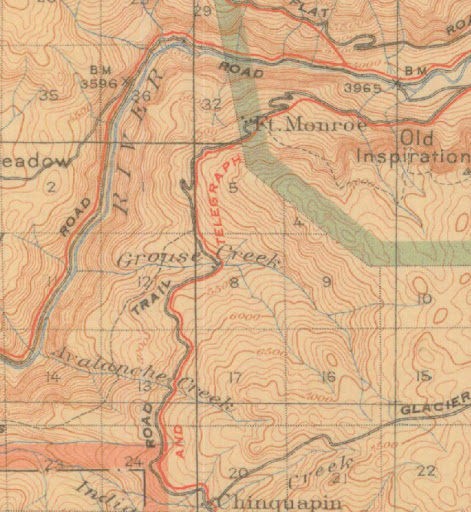


After the old Wawona Road and Fort Monroe were both abandoned, the foot trail went back to the original Mariposa alignment, i.e., directly to New Inspiration Point, then shortcutting the Wawona Road switchbacks until you hit the old road again. There you had the choice, as you do today, to continue down to Discovery View or follow the old road acting as a trail to the base of Bridalveil Falls. Here is a map from the Hill's Point thread:
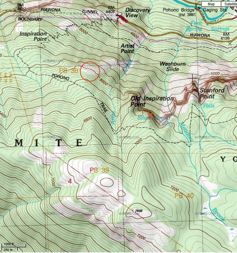


The circle and X are only relevant to that previous thread.

So the first question is, can we locate Moonlight Rock? How closely does the current trail to Inspiration Point align with the original Mariposa Trail?

Quite closely, as it turns out. We drove to Discovery View, grandkids and all, and whipped out the Muybridge photo. Stood at the trail head at the east end of the parking lot. Sighted the alignment of Lower Cathedral Rock, Sentinel Rock, Half Dome, etc. Humpf. We were only fifty feet from our destination. They have built their parking lot and trail head at the base of Moonlight Rock, and right athwart the original Mariposa Trail!


A few steps up the trail, and you can see the same little escarpment that Muybridge did, and the same panorama (except for some trees blocking the view) if you step out onto the wet rock. Of course, the view from the parking lot is virtually the same. A photo that took Muybridge half a day to produce in 1872 now takes ten seconds.


I expect that it was called "Moonlight Rock" because it glistens in the sun when wet with moisture, which is most of the time in the Spring:


So much for that bushwhack. We went on with the planned hike to Inspiration Point, and down the old road to the base of Bridalveil Falls.

But this all leaves us with another bit of untrodden abandoned trail.....the Mariposa Trail from Discovery View and Moonlight Rock down to the Pohono Bridge. There aren't many route choices, because it is all cliffs to the west and somewhat steeper to the east. If you look at the topo map above, you'll see where to look for the old trail. If Chick-on doesn't get there first, we'll check it out some day when we only have time for a short hike....


Edited 2 time(s). Last edit at 05/04/2013 09:08PM by wherever.
Re: Moonlight Rock on the old Mariposa Trail (long)
April 21, 2013 04:05PM
Awesome! I've seen Moonlight Rock before without knowing what it was. I, too, am very interested in what has become of the long abandoned (since 1876, I presume) segment of the Mariposa Trail from Moonlight Rock down to the valley floor. Could be a fun bushwhack.

Did the Mariposa Trail follow what is now the Pohono Trail east from Old Inspiration Point toward Taft Point? If so, where did it branch south toward Wawona? Seems odd that the trail would have gone that far east rather than taking a more direct routing along the eventual Wawona Road corridor.
Re: Moonlight Rock on the old Mariposa Trail (long)
April 21, 2013 04:24PM
As I understand it, the original "Mariposa Trail" trail followed a branch coming off the southern route of the (Indian) Mono Trail up around Badger Pass. It hit the current Pohono Trail at Silver Strand Falls, after coming down Meadow Brook (which goes over the falls) The quotes are because it was named the Mariposa Trail after a lot of people at the time thought that this was the route followed by the Mariposa Battalion on its way to the first white man's sighting of the valley. But this is the indians' summer route coming from the east. In the link quoted at the start of this thread, I think that you will find a reference that tries to prove that the Mariposa Battalion used a lower or Spring route, because there was still snow on the ground, and that the first sighting of the valley was actually from New Inspiration Point.

Anyway, the route that did go more directly to Wawona was called the Mann Trail, I think. It hooked up with the Mariposa/Pohono Trail somewhere near Old Inspiration Point. I'm sure that some people in this forum have much more detailed info on that than I do. But I have never seen any reference to the exact route down from Moonlight Rock to the crossing of Artist Creek and the Pohono Bridge. This was a heavily traveled route until the first road went in, and there might be something to see, just as there was along the Old Big Oak Flat Horse Trail (for that, see http://yosemitenews.info/forum/read.php?3,48394,48394#msg-48394)....
Re: Moonlight Rock on the old Mariposa Trail (long)
April 21, 2013 05:07PM
Really love these old road threads. Keep them coming.
Re: Moonlight Rock on the old Mariposa Trail (long)
April 21, 2013 07:00PM
Quote
wherever
OK, this post won't be very interesting unless you like to read about the abandoned old roads and trails in Yosemite Park.

Well, I expect you know by know that I'm firmly in the "unless" group! Thanks for this really interesting thread. I don't recall having come across the Moonlight Rock moniker before so this was an especially cool read for me. Thanks, also, for the details of the realignment time frames of the Pohono Trail...I'd seen it move around on maps from various periods but (especially given my interest in the Old Wawona Road), I'm a bit embarassed that I never made the connection between why the realignments happened when they did!

Quote
wherever
But this all leaves us with another bit of untrodden abandoned trail.....the Mariposa Trail from Discovery View and Moonlight Rock down to the Pohono Bridge.

And just when I thought I was getting to check off most of my "really-need-to-check-that-out" bits of lost road/trail in that part of the park... grinning smiley
avatar Re: Moonlight Rock on the old Mariposa Trail (long)
April 22, 2013 06:51AM
Awesome. Thanks. Here's another photo had stashed away in "places need to go find".
Very very cool.


And here's the overlay map of the bit of trail from Discovery down to Pohono Bridge:

(as you linked it's also in the BOF Horse Trail)

I don't have enough digits on my flippers to count how many times been looking at old maps and find another segment
of trail that no longer exists. And then there's the old railroad beds...


Chick-on is looking at you!
Re: Moonlight Rock on the old Mariposa Trail (long)
June 09, 2013 09:38PM
We drove to Yosemite on Wednesday, and had three hours to kill in the afternoon. So we checked out the old Mariposa Trail from Moonlight Rock (aka Tunnel View) down to the Pohono Bridge, as was suggested previously on this thread.

One thing that you will find on that old trail is a viewpoint that I guarantee that you have never seen in a photo before.


Of course, the mule drivers wouldn't have thought twice about cutting a few trees that are blocking the view. They would have considered it a public service...

You can compare the above photo with the view taken an hour later from the parking lot:


I think that the view of Cathedral Rocks is nicer in the first view....

The air was hazy, the sky was overcast, and there was occasional drizzle. So the sky in those photos is too bright compared to the landscape. Sorry.

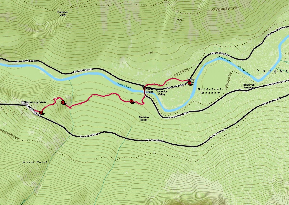
We started our hike at the Valley View parking spot, but we could have used the parking spot at the south end of the Pohono Bridge, or one of the many at Fern Spring. After some thought, we decided that the old Indian trail would have gone past Fern Spring, before any bridges existed, and we left the road there. As a result, we started up the hill too soon, and ended up scrambling across several unpleasant narrow ravines, before we backed down and picked up the trail near its middle. The gps trace below is from our return trip. The route description below reads as if you are starting at the tunnel mouth and heading down to the bridge. It's the faster route, anyway, and can be done in that direction in an hour.


This is a view from Google earth, looking south. The tunnel parking lot is in the upper right hand corner. You can just make out Moonlight Rock above the left end of the parking lot, and the part of the Mariposa Trail presently in use (aka Pohono Trail) going up from the middle of the parking lot. A hundred yards or so of the old trail, which ran at the foot of Moonlight Rock, is now covered by asphalt and dirt fill. The waypoint shown was punched in when we first hit the old trail while going down.

To get there, go to the farthest east end of the parking lot. Looking down from there, you will see a small ravine starting at that point, and you have to traverse to the right across dirt fill to get onto its east bank. You will find the old trail there (waypoint start), just as it disappears beneath a half dozen or so fallen trees. Pass those on the left and pick up the trail beyond them, heading down to the right.

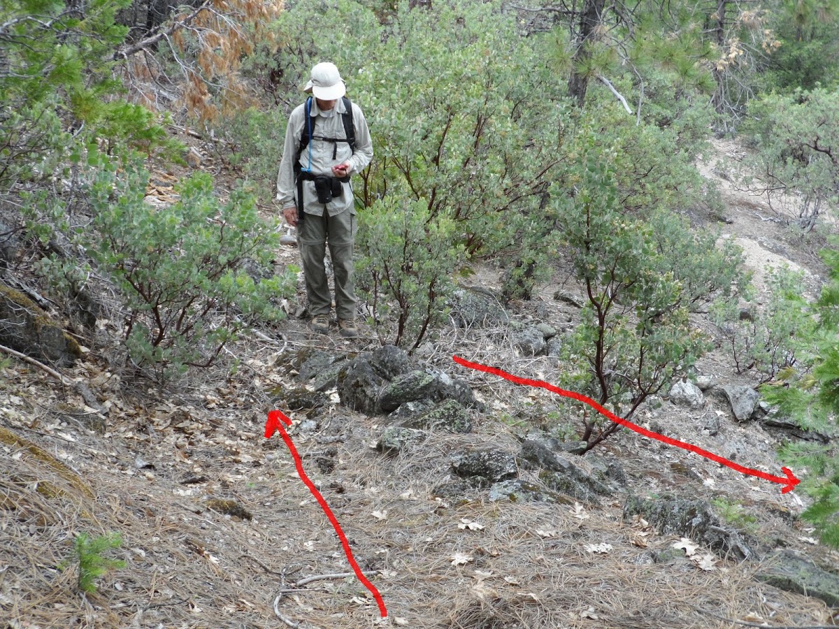
The only switchbacks on the entire trail are in this next section, going down to the lookout. Maybe four or so. The trick is to not lose the trail in a brief band of manzanitas just above the lookout. Beyond that point, we had no difficulty following the trail until we neared the waypoint end. There is no masonry stonework, but stones have been moved to either side of the trail, and there is a small dip in the surface where the mules walked. It looks like a hiking path, and is very similar to the old horse trail on the north side of the valley, which was in use at the same time. Here is a photo of one of the few switchbacks:


And here is a map from gmap4, with north at the top:


The waypoint marked end is the last place where the trail is clearly distinct. I think that the trail went to Fern Spring, and/or to the 1870s bridge, and/or to the south side valley road at various times. The ground has been disturbed by road building and a buried phone line, so the last hundred yards of the trail to the bridge has become diffuse.

Compared to what it was like where we tried to go up too soon, the trail is routed perfectly to obtain the easiest route. Except for some things growing in the way, it is a very pleasant hike. But what else would you expect from the people who lived here for thousands of years before we showed up?

It would take almost no effort to restore this as a hiking trail. Just cut down some brush. There is no stonework to restore. The crossing of Artist Creek and of the other small creeks were all dry during this early part of June. The creek crossings might be awkward in a Spring flood, but lots of hiking trails have this property....
avatar Re: Moonlight Rock on the old Mariposa Trail (long)
June 11, 2013 11:01PM
Quote
wherever

It would take almost no effort to restore this as a hiking trail. Just cut down some brush. There is no stonework to restore. The crossing of Artist Creek and of the other small creeks were all dry during this early part of June. The creek crossings might be awkward in a Spring flood, but lots of hiking trails have this property....


It would be totally cool if the Park Service restored this trail as an extension of the current Pohono Trail. Note how appropriate the name would be with the Pohono Trail – after the restoration – starting (or ending) at the Pohono Bridge! smiling smiley

.
Re: Moonlight Rock on the old Mariposa Trail (long)
June 12, 2013 12:55AM
Quote
plawrence
Quote
wherever

It would take almost no effort to restore this as a hiking trail. Just cut down some brush. There is no stonework to restore. The crossing of Artist Creek and of the other small creeks were all dry during this early part of June. The creek crossings might be awkward in a Spring flood, but lots of hiking trails have this property....

It would be totally cool if the Park Service restored this trail as an extension of the current Pohono Trail. Note how appropriate the name would be with the Pohono Trail – after the restoration – starting (or ending) at the Pohono Bridge! smiling smiley
.

I was a bit too glib there. You would also have to cut through a bunch of fallen logs....

Anyway, it's not going to happen. They would have to make some more parking places, either at the bridge or at nearby Fern Spring. That's a bigger deal than the trail work that would be needed.
avatar Re: Moonlight Rock on the old Mariposa Trail (long)
June 12, 2013 01:11AM
Not necessarily in regards to the parking spaces. They could keep the current Pohono Trail starting point at Tunnel View as the official one for backpacking and wilderness permits purposes and have backpackers park their vehicles there.

The trail down to the Pohono Bridge would be mainly for the purpose to elegantly connect the Pohono Trail with the Yosemite Valley Loop Trail — a worthwhile endeavor in my humble opinion.

.
avatar Re: Moonlight Rock on the old Mariposa Trail (long)
November 04, 2013 07:18AM
Tanks for this. Finally did it yesterday:


smiling smiley

If anyone does this (does anyone?) ... be prepared for a bushwhack and looking for the trail in various spots...
and climbing over and under and around a number of fallen logs. Not a problem xcountry... but more of an
issue when trying to follow a trail. Anywho. Thanks for this. Much appreciated.
(I'd post a GPS track... but the one above is stellar... and you'd just say "wth were you DOING?!" ) tongue sticking out smiley


Chick-on is looking at you!
Re: Moonlight Rock on the old Mariposa Trail (long)
June 10, 2013 05:58PM
Fantastic! Another short hike to schedule for my next visit! Thanks so much for sharing!
Sorry, only registered users may post in this forum.

Click here to login