Welcome! Log In Create A New Profile Recent Posts
Tenaya Lake, Yosemite National Park

The Moon is Waxing Gibbous (60% of Full)


Advanced

Re: A Four Mile Trail track for gophersnake

All posts are those of the individual authors and the owner of this site does not endorse them. Content should be considered opinion and not fact until verified independently.

avatar A Four Mile Trail track for gophersnake
May 09, 2013 09:22PM
It includes some perhaps interesting tidbits...

(hiked part of the old trail in a couple of places)

Track has not been modified at all other than where we went after GP proper has been removed.

from Garmin eTrex30

Click here for Z Track on Gmap4

If you click on Satellite... you can really zoom in...

Have fun


Chick-on is looking at you!
avatar Re: A Four Mile Trail track for gophersnake
May 10, 2013 07:34AM
Well... I guess that went over well...

How about this track of 4 Mile + old part by Union Pt. + trek up to Base of Sentinel
Completely from GPS. Not a bit of touch-up.

Click Here

Done all the Old 4 Mile sections that I know about (thx to the people who share on this site)
but not in one fell swoop... so for that I'd have to play with a number of files...


Chick-on is looking at you!
avatar Re: A Four Mile Trail track for gophersnake
May 10, 2013 07:40AM
Quote
chick-on

Done all the Old 4 Mile sections that I know about (thx to the people who share on this site)...


How about the old alignment of the Four Mile trail, that according to one of the old overlay's that you posted, supposedly went by Moran Point. wink

.
avatar Re: A Four Mile Trail track for gophersnake
May 10, 2013 07:46AM
Wha! Purty shure ur trying to lead me on a wild chick-on chase again...

It was just a spur.

http://yosemitenews.info/forum/read.php?3,38632,38632#msg-38632


Chick-on is looking at you!
avatar Re: A Four Mile Trail track for gophersnake
May 10, 2013 10:37AM
I was actually referring to this part of an overlay map that you posted on Sept. 2011:

http://yosemitenews.info/forum/read.php?3,46585,47062#msg-47062


wink
avatar Re: A Four Mile Trail track for gophersnake
May 10, 2013 11:11AM
You mean this?

http://yosemitenews.info/forum/read.php?3,47695,47695#msg-47695

(ewe shood change ur login id to turk-ee)

tongue sticking out smiley


Chick-on is looking at you!
avatar Re: A Four Mile Trail track for gophersnake
May 10, 2013 11:14AM
Reading that thread... obviously I have a worked track already... now I just need to find it...


Chick-on is looking at you!
Re: A Four Mile Trail track for gophersnake
May 10, 2013 01:28PM
While poking around for something else awhile ago* I came upon this historical photo:


Wikimedia Source

This picture seems to be from around 1902 (or 1905)-ish, if not earlier. Although not conclusive, it appears that the 4MT switchbacks that can be seen are consistent with the known location of the "old 4MT route" that chick-on and others have recently re-traced. (That said, the one steep trail leading up/right from Union Point is probably the old gravity-fed, wooden-pipe water system, not the 4MT itself.)

(* Unfortunately, this photo didn't shed any light onto the location of the Eagle Peak benchmark...)
avatar Re: A Four Mile Trail track for gophersnake
May 12, 2013 11:32AM
Great photo. If I was a stickler I'd say that's not exactly Eagle Peak... and that the benchmark
wasn't put up until later... but I wouldn't do that.

Took that photo and flopped that trail onto pix took from Eagle Pk:


Well... as close as I could get it...

Then from there took another look at the 1918 map with current GP trail on it:


and the 1938 map with current GP trail on it:


From the 38 just not sure how much more old trail there is out there hiding other than what we have
already found. The track of the Union Pt. section isn't perfect... need to redo that one...

O well... prob. way TMI... had fun doing it though. Thx


Chick-on is looking at you!
avatar Re: A Four Mile Trail track for gophersnake
May 10, 2013 01:13PM
Quote
chick-on
a wild chick-on chase again...

Isn't that what you do most weekends?
avatar Re: A Four Mile Trail track for gophersnake
May 10, 2013 04:36PM
Quote
eeek
Quote
chick-on
a wild chick-on chase again...

Isn't that what you do most weekends?

Sure... but that's self-inflicted


Chick-on is looking at you!
avatar Re: A Four Mile Trail track for gophersnake
May 11, 2013 02:11PM
Thanks, chick-on. smiling smiley Another one for my collection. I hope you (and gmap) don't mind that I downloaded some screen shots to study later.

What was that loop in the track, a little way after the creek crossing? Did you actually go exploring below the trail? If so, what did you find? I've sometimes wondered exactly where the trail (current version) runs relative to the cliffs above and below, but I thought I'd rather resolve that by mapping than by bushwhacking.

My mapping data are still pretty rough, with some known errors that I was hoping to resolve this summer. I wasn't going to post any of it for a while yet but since we've opened up the subject, here goes. I'm going to focus here on the lower (west) end of the trail, below about 5000'. Here's how I plotted that part:


Here are the same data overprinted on a topo map. I apologize for the quality. One image was a TurboCad drawing of my plot, the other a .jpg of the map. They weren't real compatible so I literally overprinted them by running the same sheet through the printer twice. What you see here comes from a scan of the result. The thin black line is my plot; the broken blackish lines are a mix of the trail as shown on the map and poorly-rendered contour lines. I hadn't discovered gmap yet when I made this; next time I'll get my map from there.


I should mention that the dashed blue lines are radials from Columbia Rock. I can see CR from many places along the trail, so taking bearings to it gives me a check on my position. My compass (see my avatar) reads to 1/2 degree. Allowing for errors, I can still guess at my location within a hundred feet or so and (equally important) know where to look from Columbia Rock for the landmarks that I've noted while on the trail.

Here's the plot I made from the GPS data at the Trimble site:


Looking only at the lowest ("Bottom" ) series of switchbacks, between Southside Drive and the creek crossing, I like my version about the best. I know there are six switchbacks, and roughly how they're shaped. Your plot shows more than six, and the Trimble plot does some strange things to the shape of the uppermost switchback ("B6" ).

For me, this isn't the most interesting part of the trail but it's the part where I have the most complete data. I'm especially interested in the "Long" series of switchbacks, just above the area in these pictures. The topo shows 25 switchbacks in that series but I count 35. Several trail sections are so short, 30' or less between switchbacks, that it would be hard to show them on a topo. Those make especially good landmarks though, precisely because if I can see a pair of switchbacks only 30' apart, I can be sure I'm not looking at "L19" and "L20" (about 580 feet apart).
avatar Re: A Four Mile Trail track for gophersnake
May 11, 2013 04:17PM
At home... so I spent some time putting together the various pieces had lying around.
First of all... thanks to everyone here that contributes to this sort of thing.
Many years ago I asked on this site about old maps and trails... and it has really
blossomed. It's amazing these old maps and the number of old trails one can find.
Looking around last week found yet another couple hadn't seen before.

Anyway, I'm impressed with your mapping. Very neat. What I was showing on the
first post was that the GPS track is pretty good. Well... very very good.
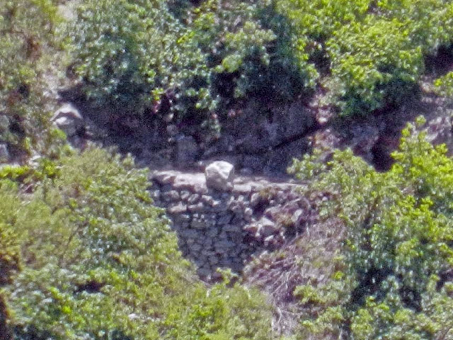
The bottom section there... that is the old trail in some pieces... I was on a hike
with the wife up 4 Mile and I just "had" to hike the old section... and then after the
creek had to again go look for the old trail... funny thing is... basilbop caught
me with my hand in the cookie jar there... unknowingly we ran into each other
and hiked that section east of the creek. It's in great shape. Above there to
the Union turnoff... I think the rest is obliterated.... so it would be interesting to
hear if anyone has seen any old portions there.

The second post has all of the lower four mile ... along with a little jaunt to base of
Sentinel Falls.
The key with those 2 posts were that you can really get some nice tracks with a good GPS.
Absolutely no post processing was done on those gpx files.

Since haven't hiked Old 4 Mile in one fell swoop... I have to edit and merge and whatnot...
But after a bit of that...

Putting it all together we end up with something like this:

Old Four Mile on modern map:

Or
Gmap4 Link with GPX Track of Old 4 Mile Trail

Here is a track of Current 4 Mile in it's entirety:
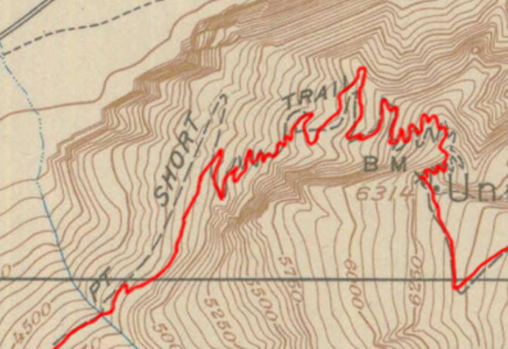
Gmap4 Link with GPX Track of Current 4 Mile Trail

If I overlay my Old 4 Mile Trail track onto a 1918 map it ends up coming out like this:


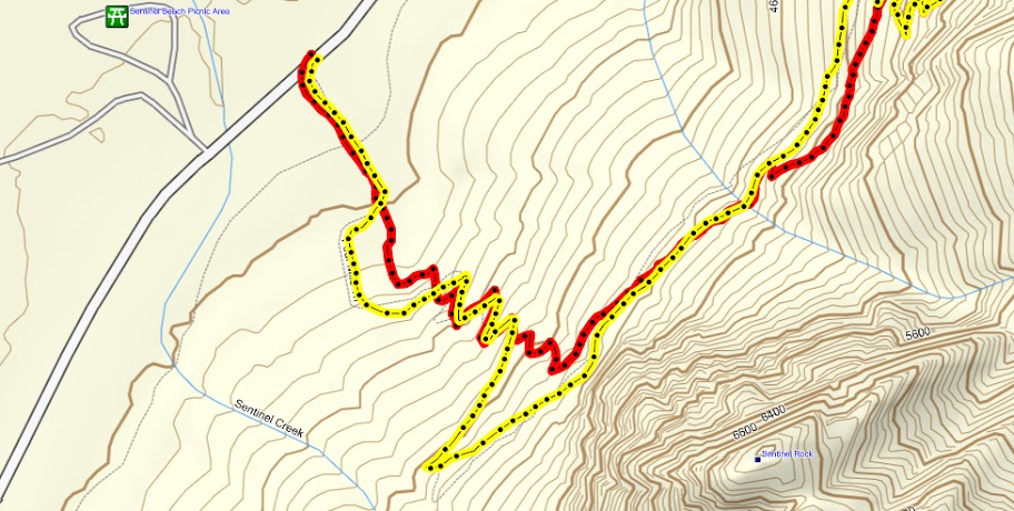
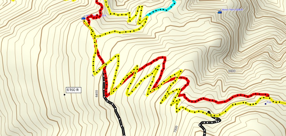
And here's a few captures of MapSource screens of my tracks:
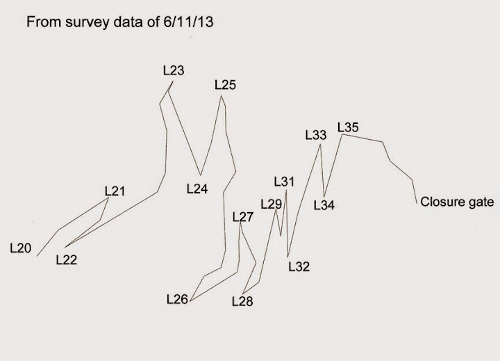
Lower Portion


Section that you said has 35 (looks about right)


Upper Switchers


And if you want... here's the whole thing on Gmap4 ... complete with trek along Waterworks and to Sentinel Trail
Gmap4 Link to GPX with 4 Mile Trails

Hopefully you find this of interest.
Feel free to snag the .gpx files and play around... and copy or d/l any of the pix.

Have fun


Chick-on is looking at you!
avatar Re: A Four Mile Trail track for gophersnake
May 11, 2013 06:13PM
Quote
chick-on

Upper Switchers


That's not the correct location of Moran Point (in the upper right-hand corner of this map), is it?

I thought Moran Point was located where the turquoise colored track was heading.
Re: A Four Mile Trail track for gophersnake
May 11, 2013 10:42PM
Quote
plawrence
That's not the correct location of Moran Point (in the upper right-hand corner of this map), is it?

I thought Moran Point was located where the turquoise colored track was heading.

You are correct. But Moran Point isn't nearly as well defined as Union Point. A lot of the photos "taken from Moran Point" are taken from the gully to the east of the rocks that contain the stonework. That spot is higher than what we think should be called the point, since the steps take you down a ways.

In any case, they have it located too far to the east. It looks like someone knew an elevation (6200 feet), and looked for a plausible "point" at that elevation.
avatar Re: A Four Mile Trail track for gophersnake
May 12, 2013 11:24AM
Yeah... I was "this close" to editing that map and removing Moran Pt. since I thought it might be asked.


Chick-on is looking at you!
avatar Re: A Four Mile Trail track for gophersnake
May 12, 2013 01:51PM
Quote
chick-on
Section that you said has 35 (looks about right)

It does, it does!! I only have data for the first 20 but here's my plot, with my switchback numbers. I call this the "Long" series (the one below the creek crossing is "Bottom", the ones above it "Short" and "Top" ).


Here's yours with my numbers added:


It looks like yours and mine agree with each other better than either one agrees with the "trail" line on the topo! grinning smiley At first it looked like yours was missing a couple of switchbacks but they're actually in there. Now I am impressed. Here's that part of yours at higher magnification:


I'm going to reread that recent GPS thread and probably start thinking about getting a GPS like yours. Kinda hate to give up my advanced low-tech technology, though. sad smiley
avatar Re: A Four Mile Trail track for gophersnake
May 13, 2013 06:50AM
Quote
gophersnake
It looks like yours and mine agree with each other better than either one agrees with the "trail" line on the topo! grinning smiley

<snip>

I'm going to reread that recent GPS thread and probably start thinking about getting a GPS like yours. Kinda hate to give up my advanced low-tech technology, though. sad smiley

The trails drawn on USGS maps are sometime woefully incorrect.
Take a look at JMT to Clark Pt.

Whereas the really old maps are incredibly detailed.

Don't give up your low-tech methods. Have fun with it.
Was just trying to enlighten a bit that GPS technology is pretty amazing... and can be
a lot of fun. For me... once I saw a GPS with maps on it... I just had to have it...
Garmin GPS 12Map... still have it... only took it along when I knew I was going off trail
Once better maps were available and they removed selective availability...
Then eventually got into taking GPS all the time and saving the tracks for fun...
Like a camera... kinda wish I'd have had it along since started this goofy journey.
It's a lot of fun.... and gives me a good idea of what there still is to see or haven't
seen in too long...
As in:


Chick-on is looking at you!
avatar Re: A Four Mile Trail track for gophersnake
June 23, 2013 10:14PM
I did some more surveying when I was there a week or two ago. I have data for the whole Long Series by now. This is still a little rough, and not to the same scale as the other one:


Going back in a few days. With luck, I might nail the Short Series then. That's the part between this ^ and the Union Point junction.

I noticed something strange in this area. There's a thin wire running at treetop height across several trail sections. I haven't found where it begins or ends. I took a few pics but they don't tell much. I'll try to get a few more soon.
avatar Re: A Four Mile Trail track for gophersnake
May 12, 2013 02:16PM
Quote
chick-on
Section that you said has 35 (looks about right)

There's something I've noticed in that section that I wanted to run by you. Several times I've looked at (and photographed) something that I guess could be a natural feature, but that looks like an old trail or road joining the current trail about 2/3 of the way from L16 to L17. Here's the pic that makes it look most like an old trail or road. The current FMT runs along the right edge of the pic:


I may learn more about this "junction" when I study your old trail/new trail tracks but I thought you (or someone) might already recognize it and know the story. For identification, here's L17. It's one of the more recognizable switchbacks with all those slanting trees:


It looks to me as though when they laid out the old and new trails, a major consideration was whether/where/how to cross those white chutes like the one beyond L17, to minimize the chances of the trail getting wiped out by an avalanche or rockslide.
avatar Re: A Four Mile Trail track for gophersnake
May 13, 2013 06:54AM
I'll take a look next time thru. I seem to recall some old time photo that looks very similar.
In that area there certainly were less switchers originally. It holds some hope that
there may be some snippets left to explore.

That's all I know.... now we wait for basilbop to tell us. wink

Thanks for all the pix and drawings. Good stuff


Chick-on is looking at you!
Re: A Four Mile Trail track for gophersnake
May 13, 2013 06:17PM
Just wanted to say a quick thank you for a really fascinating thread. Normally I'd be studying things and commenting in much more detail but just haven't had much time to spend at the computer lately (I wish I could say that was because I was out hitting the trails but it's mostly that I've been really busy with work-related stuff). Since one or two of you are probably wondering why I haven't commented on this one, trust me, it's not because I haven't been reading (and trying to soak up) every word, picture, map and track! hot smiley
avatar Re: A Four Mile Trail track for gophersnake
May 24, 2013 10:04PM
My "Four Mile Trail" project is actually several projects in one. At first it was only about coming up with a more accurate plot of the trail than the USGS topo maps showed. Later I expanded it to include pictures of all the switchbacks. Still later, I noticed that I could get a good view of the area from Columbia Rock. The project expanded to include tracking what the trail looked like from there and how to locate the parts that I couldn't see yet (or couldn't recognize when I saw them).

Last year I was scouting the trail for features near the trail that might be big enough and conspicuous enough to be recognizable from Columbia Rock. This week I spent two days on the Four Mile Trail itself (surveying and photographing) and part of a day on Columbia Rock spotting and photographing bits of the FMT. Here are a few of the connections I've made so far. First, here are the two switchbacks I'll be talking about, L13 and L18:


-----------------------------------


Stuff around L13 that I thought might be identifiable from Columbia Rock -- a rock, from below:


Same rock from above:


Same rock captured in a picture of the L13 switchback:


L13 from Columbia Rock, at extreme zoom (something like 35 to1):


-----------------------------------


Stuff around L18 that I thought might be identifiable from Columbia Rock:


L18 from Columbia Rock:


Without all the pics and data that I'd already collected, and all the questions that I'd puzzled over, there would have been no way of knowing where to point the zoom lens. I also lucked out this week; the light was good, the air was clearer than other times, and there were plenty of people on the trail. grinning smiley

More to come, eventually, but those were the highlights from this trip.
avatar Re: A Four Mile Trail track for gophersnake
June 02, 2013 02:30PM
As I said, more to come eventually.

Near the creek crossing (around the 4600-foot level, between the "Bottom" and "Long" series of switchbacks) I noticed a white rock on the edge of the trail that I thought would be visible from Columbia Rock:


Sure enough. I'd gotten previous shots of it, both from CR and from Leidig Meadow, but never under such good conditions. Here it is from CR at maximum zoom:


L1, the first switchback in the "Long Series", is near one of the conspicuous white "avalanche chutes" that cross the slope where the FMT runs. I gather that the builders of the trail tried to cross these chutes as seldom as possible and to pick their location carefully when they did. They often reinforced the slope with stonework uphill and down from the crossings. In this case they appear to have simply turned back from the chute and eventually crossed it much farther up. Here's a view of the L1 switchback showing a "use trail" into the chute:


Here are two views up the chute from near that same spot:


Here's a long zoom of the same area from Columbia Rock. As far as I can tell those are the same rocks and the same crooked doug fir, and there's a tiny glimpse of the trail at the far right:


I'm pretty new to Picasa Web. I think I made the right settings and chose the right URLs so everyone will be able to see these pics, not just me.

Still more to come, eventually. winking smiley
avatar Re: A Four Mile Trail track for gophersnake
June 02, 2013 08:11PM
Is this Gigapan of any use to you?

View from Eagle Peak of Yosemite Valley


Expand it full screen for the best effect.

You have a pretty good view of a lot of 4-mile trail.
avatar Re: A Four Mile Trail track for gophersnake
June 02, 2013 08:23PM
Quote
qumqats
Is this Gigapan of any use to you?

Yes, thank you. smiling smiley

Someone else turned me on to the views in http://www.xrez.com/yose_proj/yose_deepzoom/index.html Those are great, too. I wasn't sure if/when I'd get to Eagle Peak myself, especially schlepping a tripod and maybe a scope, but I'm sure some views from there (however I get them) will be a big help in answering questions about the trail that I haven't even thought to ask yet.

-----------------
Edited to add: I just followed the Gigapan picture link upstream (http://gigapan.com/gigapans/), ran a search for everything tagged "yosemite", waded through 37 pages of results, and bookmarked 25 or 30 for future reference. grinning smiley


Edited 1 time(s). Last edit at 06/03/2013 01:26AM by gophersnake.
Sorry, only registered users may post in this forum.

Click here to login