I have a backpacking trip planned on the 10th-14th of June. My plan was to start in Tuolomne and go down Lyell Canyon to Donahue Pass>Agnew Pass>Parker Pass and back to Tuolomne.
Im looking for opinions on whether or not there will be too much snow to do the route in June, as well as any wisdom from people more experienced with the area.
Thanks, happy hiking.

The Moon is Waxing Gibbous (56% of Full)
Re: Donahue Pass
All posts are those of the individual authors and the owner
of this site does not endorse them. Content should be considered opinion
and not fact until verified independently.
|
Donahue Pass May 29, 2013 08:03PM | Registered: 10 years ago Posts: 15 |
|
Re: Donahue Pass May 29, 2013 09:24PM | Registered: 13 years ago Posts: 864 |
There is still a fair amount of snow in the high country, and I wouldn't be surprised to encounter snow near Parker, Gem and Donohue Pass--but not Koip Peak Pass, which despite being higher melts out sooner.
Here are some pre-parrot pictures from a trip we did July 4th 2006, which was an unusually wet year:
Parker Pass:
Koip Peak Pass:

Approaching Gem Pass from the north:

And Donohue Pass:

The snow wasn't the worst part of the trip... it was the high water crossings, especially (and surprisingly) Crest Creek (slippery and swift), but also crossing both the outlet of Alger Lakes and the Lyell Fork on snow bridges.
I doubt mid-June this year will be as bad, and it looks like the next several days will be warm.
More Pix
Here are some pre-parrot pictures from a trip we did July 4th 2006, which was an unusually wet year:
Parker Pass:
Koip Peak Pass:
Approaching Gem Pass from the north:
And Donohue Pass:
The snow wasn't the worst part of the trip... it was the high water crossings, especially (and surprisingly) Crest Creek (slippery and swift), but also crossing both the outlet of Alger Lakes and the Lyell Fork on snow bridges.
I doubt mid-June this year will be as bad, and it looks like the next several days will be warm.
More Pix
|
Re: Donahue Pass May 30, 2013 03:35PM | Registered: 12 years ago Posts: 953 |
If memory serves, we didn't actually follow the trail that year all the way to Gem Pass, but cut up to the ridge on the east and XC'd on top of the ridge to meet back up with the trail. And when I say cut up, Aaron used a little ice axe to cut steps in a few places, cuz we were going UP. Though one map I'm looking at has non-switch option...but there was so much snow.. If it exists, we wouldn't have seen it, I think...
And that Crest Creek crossing? Lets say I remember it vividly. It was before I was truly conditioned for icy water, we were in shade, and the combination of cold and fast with big penalty for screwing up... Yah.. Thrill for me back then... Lifting a pole or a foot, it would get swept back and I'd fight to plant it solidly again. Only moved one point out of four at any one time.
And that Crest Creek crossing? Lets say I remember it vividly. It was before I was truly conditioned for icy water, we were in shade, and the combination of cold and fast with big penalty for screwing up... Yah.. Thrill for me back then... Lifting a pole or a foot, it would get swept back and I'd fight to plant it solidly again. Only moved one point out of four at any one time.
May 29, 2013 09:28PM | Moderator Registered: 14 years ago Posts: 7,421 |
Honestly I think you should just go for it. Donahue MAY be suncupped goodness
(which means not so much fun)... but the hike up Lyell will for sure be nearly
entirely snow free... once you drop from Donahue the snow should go away...
(I'm basing this on a trip we did in very early July on a much snowier year btw)
You'll have plenty of company so staying on trail imo should not be a problem.
(It IS the JMT)
If you take more than what you think to get to Agnew then maybe you can
consider taking shuttle back from Red's (YARTs?)
Did this same trip in reverse a few years ago:
http://yosemitenews.info/forum/read.php?3,27023,27023#msg-27023
There should be a bit less snow for your trip. N. of Gem Pass was the
only MINOR issue then... I'd expect maybe the same... but judging by QITNL
view of Koip Peak Pass switchers... you should be good to go then.
Be save and have fun
|
Re: Donahue Pass May 30, 2013 12:46AM | Registered: 10 years ago Posts: 15 |
Thanks for the replies!
Unfortunately I cannot take the YARTS from Mammoth to Tuolomne because our schedule dictates we end our hike mid week, and the tram only runs on the weekends.
What is the likely snow situation at the high passes in the ansel adams area in mid june? I just want to avoid a bad situation.
I am totally the "go for it" type, but i want to know what im getting myself into, what gear i will need, ect beforehand.
Love the pics in the forum BTW, especially chick-on.
Edited 2 time(s). Last edit at 05/30/2013 12:50AM by iLOVEyosemite.
May 30, 2013 07:51AM | Moderator Registered: 14 years ago Posts: 7,421 |
Take a look at boat peekchure sets... that will give you a good idea.
Z Perret showed some good ones already. Expect that-ish.
You should be able to work your way around Gem and the others you'll just
have to ziggy thru. If it's suncup heaven then it's slow going... but safe.
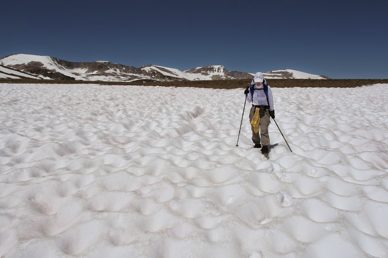
To help a bit more perhaps... here's what I'd expect Koip to look like...
Algers is in the foreground...

Again, stickler MAY be Gem..
Look at Perrets again... and then this is what it looked like for us:

I started going straight thru this... postholed thru... and started sliding down a bit... so we went down further ...
we brought kahtoolas... but those were pretty useless.... crampons they are not...
here's after we got thru it:

iirc there are 2 trails N of Gem which the pix are... one which works around the snow field which can persist longer
So... my 2 dollars worth is simply to hike up Lyell... go up to Donahue... if you hate it... then simply turn around and
camp in upper Lyell and explore... (you do NOT have to exit the TH that it says on your permit.. )
Or just grin and bear it... and get over Donahue entirely and go explore 1000, etc. That will be pretty free from what
I've seen so far. The snow can be a lot of fun... It's actually better if there is a LOT more snow ...
less snow that gets all suncupped and you sink a foot or more... not so great.
Have fun whatever u do
Z Perret showed some good ones already. Expect that-ish.
You should be able to work your way around Gem and the others you'll just
have to ziggy thru. If it's suncup heaven then it's slow going... but safe.
To help a bit more perhaps... here's what I'd expect Koip to look like...
Algers is in the foreground...
Again, stickler MAY be Gem..
Look at Perrets again... and then this is what it looked like for us:
I started going straight thru this... postholed thru... and started sliding down a bit... so we went down further ...
we brought kahtoolas... but those were pretty useless.... crampons they are not...
here's after we got thru it:
iirc there are 2 trails N of Gem which the pix are... one which works around the snow field which can persist longer
So... my 2 dollars worth is simply to hike up Lyell... go up to Donahue... if you hate it... then simply turn around and
camp in upper Lyell and explore... (you do NOT have to exit the TH that it says on your permit.. )
Or just grin and bear it... and get over Donahue entirely and go explore 1000, etc. That will be pretty free from what
I've seen so far. The snow can be a lot of fun... It's actually better if there is a LOT more snow ...
less snow that gets all suncupped and you sink a foot or more... not so great.
Have fun whatever u do
|
Re: Donahue Pass May 30, 2013 09:07AM | Registered: 13 years ago Posts: 43 |
From the few PCT posts I've seen and also folks on the JMT Yahoo Groups page, there is some snow on north side of the higher passes but nothing to be terribly concerned about in terms of getting lost. http://groups.yahoo.com/group/johnmuirtrail/message/30793
|
Re: Donahue Pass May 30, 2013 08:39PM | Registered: 10 years ago Posts: 15 |
|
Re: Donahue Pass May 30, 2013 08:50PM | Registered: 10 years ago Posts: 115 |
May 30, 2013 09:01PM | Registered: 13 years ago Posts: 1,351 |
Yosemite, SEKI, Inyo, Sierra NF, etc. permits are from the location of your starting trailhead, regardless of what agency is managing the land you're hiking into. In the SIerra the exceptions I'm aware of (not counting areas without permit requirements) are Desolation Wilderness (based on 'first night camping zone') and Mokelumne Wilderness' Carson Pass Management Area (permit designates campsite locations).
Edited 1 time(s). Last edit at 05/30/2013 09:02PM by ttilley.
Edited 1 time(s). Last edit at 05/30/2013 09:02PM by ttilley.
|
Re: Donahue Pass May 30, 2013 10:14PM | Registered: 10 years ago Posts: 115 |
Thanks! With all the postings on Cherry Creek, I seem to have a bit of a mind block on everything else. I think the only way to remove it is to go check it out next spring! That area seems to be on the border of YNP, Stanislaus NF and the Emigrant Wilderness. As soon as I take a closer look to see where I want to go, your comment on permits will come to light! I'm just glad that you do not need to apply for individual permits...
May 30, 2013 10:00PM | Moderator Registered: 14 years ago Posts: 7,421 |
Do you mean Mono Pass TH? Or some other east side TH (mono trail side meaning Mono Lake) ???Quote
iLOVEyosemite
After some consideration I think we may start from the mono trail side and end at Lyell Canyon.
I forgot to mention that if you are trying to do an entire loop... be aware that there is no trail on the
south side of Tioga road connecting Lyell Canyon to Mono Pass TH.
The ford(s) may be a challenge early.
|
Re: Donahue Pass June 01, 2013 04:39PM | Registered: 10 years ago Posts: 15 |
Yes i think its mono pass trailhead, then instead go up to parker/koip.Quote
chick-on
Do you mean Mono Pass TH? Or some other east side TH (mono trail side meaning Mono Lake) ???Quote
iLOVEyosemite
After some consideration I think we may start from the mono trail side and end at Lyell Canyon.
I forgot to mention that if you are trying to do an entire loop... be aware that there is no trail on the
south side of Tioga road connecting Lyell Canyon to Mono Pass TH.
The ford(s) may be a challenge early.
My plan is to park in TM and take the tram to the mono pass trailhead then end in TM.
This is the trail. http://www.everytrail.com/view_trip.php?trip_id=1284018
June 01, 2013 05:30PM | Moderator Registered: 14 years ago Posts: 7,421 |
That's what I thought. I guess I should have just said everything at the time...
Yes, it's Mono Pass TH.... I presume you didn't look at the pictures in the TR I posted here:
http://yosemitenews.info/forum/read.php?3,27023,27023#msg-27023
(posted above)
There's a map at the end... that stays mostly on trail ... (I quit putting maps b/c I
have a really hard time staying on trails) (on purpose)
Anywho... I asked b/c I just wanted to point out what I already said but also should
have said that it is quite possible that the TM Shuttle is not running yet when you go.
Prob. not a huge deal... but a minor inconvenience...
(or you can just hike back to your car like we did... )
)
Have fun
Yes, it's Mono Pass TH.... I presume you didn't look at the pictures in the TR I posted here:
http://yosemitenews.info/forum/read.php?3,27023,27023#msg-27023
(posted above)
There's a map at the end... that stays mostly on trail ... (I quit putting maps b/c I
have a really hard time staying on trails) (on purpose)
Anywho... I asked b/c I just wanted to point out what I already said but also should
have said that it is quite possible that the TM Shuttle is not running yet when you go.
Prob. not a huge deal... but a minor inconvenience...
(or you can just hike back to your car like we did...
)Have fun
|
Re: Donahue Pass June 01, 2013 05:50PM | Registered: 10 years ago Posts: 15 |
Quote
chick-on
That's what I thought. I guess I should have just said everything at the time...
Yes, it's Mono Pass TH.... I presume you didn't look at the pictures in the TR I posted here:
http://yosemitenews.info/forum/read.php?3,27023,27023#msg-27023
(posted above)
There's a map at the end... that stays mostly on trail ... (I quit putting maps b/c I
have a really hard time staying on trails) (on purpose)
Anywho... I asked b/c I just wanted to point out what I already said but also should
have said that it is quite possible that the TM Shuttle is not running yet when you go.
Prob. not a huge deal... but a minor inconvenience...
(or you can just hike back to your car like we did...
Have fun
According to the website it says the shuttle runs from June to mid September, but can vary from year to year. I guess I should call and make sure that it will be running on the 10th, but since its been such a dry year id assume things would be ahead of schedule up there. Ill try to remember to call tomorrow.
Any yes i saw your pictures, thanks, they have allowed me to kind of form a mental image of what the hike looks like which could be useful if the conditions are dicey up there.
Sorry, only registered users may post in this forum.

