We went to Mt. Watkins last Friday and took some panoramic images.
http://panoramas.aa6g.org/MtWatkins/mtwatkins.html
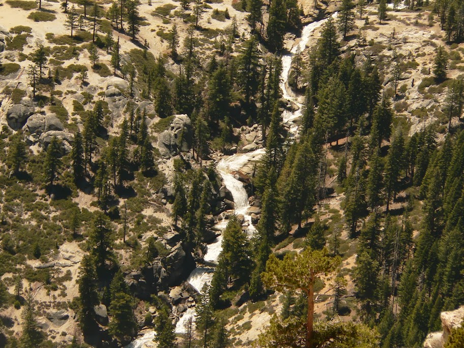
Be sure to scroll down on Half Dome to see hikers on the cables and down on Pywiak Cascade for higher res images.
Our inspiration to try this hike was this post by wherever:
http://yosemitenews.info/forum/read.php?3,57351
I wanted to add a couple of things. We parked on the south side of Tioga Road and started down towards the equipment yard. We went up the old blocked off road to the quarry on the right. The trail continued to the left of the quarry. We did not go above the quarry. In about 15 minutes you reach the spot where the trail veers to the right and heads downhill. About 50' before this there is a use trail that branches to the left. Take this trail all the to where it intersects with the larger trail coming from Olmstead Point. This section of the use trail is very distinct and there are occasional metal makers in the trees along the way. Once past the trail intersection at the saddle and heading up hill the use trail becomes less distinct but by this time there's no chance of getting lost since you're on the north end of Mt. Watkins. On the way back we took the side trip over to the eastern spur of Mt. Watkins where the excellent views of Pywiak Cascade are. The place to leave the use trail for this detour is just up from the trail intersection on the Mt. Watkins side. You can see that's it's an easy walk through the open forest. The views are worth the extra time.
I'd recommend this hike for anyone wanting to get their first "off the main trail" hiking experience. This hike is much easier than going to North Dome.
Edited 1 time(s). Last edit at 06/04/2013 06:28PM by Calaveras.
All posts are those of the individual authors and the owner
of this site does not endorse them. Content should be considered opinion
and not fact until verified independently.
June 04, 2013 01:09PM | Registered: 12 years ago Posts: 229 |
June 04, 2013 01:47PM | Moderator Registered: 14 years ago Posts: 7,421 |
The metal markers are ski trail makers. This is the normal route to May Lake in the winter.
This "trail" seems to have become popular enough that a "real" trail has developed the last 5 yrs or so.
The other ones I can think of that are similar is the "Ghost Forest" trail near Bridalveil...
and the trail from Summit Meadow to Dewey Pt.

This "trail" seems to have become popular enough that a "real" trail has developed the last 5 yrs or so.
The other ones I can think of that are similar is the "Ghost Forest" trail near Bridalveil...
and the trail from Summit Meadow to Dewey Pt.
|
Re: Mt. Watkins June 04, 2013 02:27PM | Registered: 14 years ago Posts: 755 |
Quote
chick-on
The metal markers are ski trail makers. This is the normal route to May Lake in the winter.
This "trail" seems to have become popular enough that a "real" trail has developed the last 5 yrs or so.
The other ones I can think of that are similar is the "Ghost Forest" trail near Bridalveil...
and the trail from Summit Meadow to Dewey Pt.
It should have been made the main trail, once horses became scarce there. I believe that the official trail (that runs on the west flank of the ridge) takes that very dull route only to please the stockmen, who have their own ideas about water and browsing, etc. The ski trail is much superior.
June 04, 2013 04:58PM | Moderator Registered: 14 years ago Posts: 7,421 |
The trail that goes to May from Snow Creek bridge is actually pretty nice. You can make it nicer by
... well... heading out onto the granite for a bit and get some really nice views.
The trail that goes to Olmsted has almost no views other than woods until the Watkins saddle.
In winter I don't even follow the trail to the cabin since the views from just heading straight to the
cabin are superior. And the views from just south of the cabin are spectacular.
The trails are almost always the path of least resistance to get from pt. A to pt. B.
Views weren't high on the criteria it seems.
I think I have some nice/halfway decent pix taken from near SnowCrk->May Lake trail...
June 05, 2013 07:09AM | Moderator Registered: 14 years ago Posts: 7,421 |
This is what I'm talking about:
View from Snow Creek - > May Lake Trail:

View from off the trail in granite nicety:

Great views of THE Dome there too...
The cliff there ... there are decent views of it from near the Snow Creek->Watkins Saddle/Olmsted Trail... but you have to go
off trail. The cliff has some really nice features... worth checking out... it would be a feature people would go to if it were
in many other places other than Yose.
View from Snow Creek - > May Lake Trail:
View from off the trail in granite nicety:
Great views of THE Dome there too...
The cliff there ... there are decent views of it from near the Snow Creek->Watkins Saddle/Olmsted Trail... but you have to go
off trail. The cliff has some really nice features... worth checking out... it would be a feature people would go to if it were
in many other places other than Yose.
June 04, 2013 05:37PM | Moderator Registered: 14 years ago Posts: 7,421 |
Some more Watkins stuff for those interested:
http://yosemitenews.info/forum/read.php?3,44911,44911#msg-44911

http://yosemitenews.info/forum/read.php?3,21074,53854#msg-53854
http://yosemitenews.info/forum/read.php?3,44911,44911#msg-44911
http://yosemitenews.info/forum/read.php?3,21074,53854#msg-53854
|
Re: Mt. Watkins June 04, 2013 07:43PM | Registered: 13 years ago Posts: 931 |
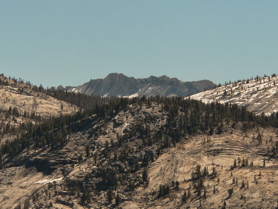
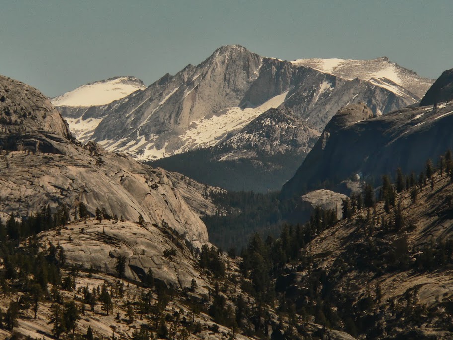
All right, I'll give in. Since this is one of my favorite mountains, I'll post a few recent trip photos. I'll no longer be adding. Different shades of color are due to two cameras, one of which is currently beyond my meager capabilities (old Lumix FZ20).
With all the focus on Pywiack, rightfully so, I believe I've mentioned before that people shouldn't ignore Snow Creek on the other side:
Luke Skywalker's landspeeder, in granite (sort of):

Clouds Rest

Ants marching up the Half a Dummy (cables weren't up yet):

Clark and his buddies:

Francois's Crest
The good ol' Senator's
End with the classic shot:

Edited 4 time(s). Last edit at 06/04/2013 08:51PM by Ohnivy-Drak.
With all the focus on Pywiack, rightfully so, I believe I've mentioned before that people shouldn't ignore Snow Creek on the other side:
Luke Skywalker's landspeeder, in granite (sort of):
Clouds Rest
Ants marching up the Half a Dummy (cables weren't up yet):
Clark and his buddies:
Francois's Crest
The good ol' Senator's
End with the classic shot:
Edited 4 time(s). Last edit at 06/04/2013 08:51PM by Ohnivy-Drak.
June 05, 2013 11:48AM | Registered: 15 years ago Posts: 4,173 |

|
Re: Mt. Watkins June 05, 2013 08:46PM | Registered: 13 years ago Posts: 931 |
|
Re: Mt. Watkins June 05, 2013 11:57AM | Registered: 10 years ago Posts: 15 |
June 05, 2013 01:09PM | Registered: 11 years ago Posts: 308 |
|
Re: Mt. Watkins June 05, 2013 01:47PM | Registered: 13 years ago Posts: 931 |
Quote
JasonS
Good looking stuff! I especially like the view of the people on Half Dome. Thanks for posting!
Thanks for all the kind comments. Watkins is a special place, out of this world really. Of course, the same thing can be said for every sq meter of the Park. But it's especially great for those that enjoy Tenaya Canyon & when the Cascade is going. That Clouds Rest ("Dr. Zaius"
 wall never fails to impress.
I wanted to get some shots directly down into the canyon from the Yasoo/Eastern Buttress ("landspeeder" is close to the edge), but I always chicken out. The drop-offs are just too severe, and what happened at Vernal with that poor elderly gentleman was fresh on my mind. Too much loose gravel: one slip and it could be all over.
June 05, 2013 01:59PM | Moderator Registered: 14 years ago Posts: 7,421 |

June 05, 2013 02:03PM | Moderator Registered: 14 years ago Posts: 7,421 |
Posted it before. More here:
http://yosemitenews.info/forum/read.php?3,51546,51546#msg-51546
And seriously Ive said it a zillion times ... you want photos on this site... then post them.
Not sure how many ways I have to say it.
Peace
http://yosemitenews.info/forum/read.php?3,51546,51546#msg-51546
And seriously Ive said it a zillion times ... you want photos on this site... then post them.
Not sure how many ways I have to say it.
Peace
|
Re: Mt. Watkins June 05, 2013 03:05PM | Registered: 13 years ago Posts: 931 |
June 06, 2013 07:30AM | Moderator Registered: 14 years ago Posts: 7,421 |
|
Re: Mt. Watkins June 05, 2013 04:59PM | Registered: 15 years ago Posts: 384 |
Best view of Clouds Rest slopes. Although Half Dome is close much like from North Dome, the face on view doesn't appeal to me as much as further west like from Eagle Peak. Need to carry in water if planning to camp there and would not want to be there if breezy. Most efficient route from highway starts where you noted on a trail, but for anyone with topo map skills before too long just making a direct crosscountry route along the rim provides easy rambling and interesting views.
http://www.davidsenesac.com
Edited 1 time(s). Last edit at 06/05/2013 05:00PM by DavidSenesac.
http://www.davidsenesac.com
Edited 1 time(s). Last edit at 06/05/2013 05:00PM by DavidSenesac.
Sorry, only registered users may post in this forum.

