Hello all,
I'll be doing the Grand Canyon of the Tuolumne next week from White Wolf. I'm just seeking info on a few specific things, and I welcome any general advice.
1) How are the mosquitoes this year through the canyon? I imagine it won't be too bad, with the dry year we've had? I'm still bringing the net inner for my shelter, a headnet, and a little spray bottle of Picaridin, but I just want to know what I should expect.
2) Also, considering the time and the dry year, I don't anticipate running into any difficult creek crossings; is this correct?
3) I'm going with an older gent, so our pace will be leisurely. I've already narrowed down some likely looking spots on the map, but can anyone suggest from experience good campsite locations between WW and GA, 5 nights worth? We're thinking about staying two nights in GA so we can day hike out to Young Lakes or May Lake, but we aren't opposed to spending two nights elsewhere if there's something better to see. Also, are there good campsites near or just past Morrison Creek, in case we don't complete the descent from White Wolf on the first day?
4) I'm aiming to get a decently early start each day but make camp in early to mid-afternoon. I'm hoping that once we set up camp, I'll have enough time to do side-trips on my own. Any suggestions for nice side-trips from the trail route? I'm reasonably fit, consider myself an intermediate to advanced hiker/backpacker, and love to get off-trail for the solitude and different perspectives on the surroundings. I have a little experience in the Sierra, more day hikes than backpacking. I'm not an expert at navigation yet, but I consider myself competent at terrain recognition and using a map. I also lean towards the risk averse side of the spectrum, espeically when solo, so feel free to recommend anything; I'll decide if its too dicey or ambitious for me.
5) When we're in GA, I'm hoping to get out to Young Lakes via Conness Creek. Anyone know if there are obstacles that would make this a problem? Should we just xc to connect with the trail from the Tuolumne Meadows trailhead? My friend is definitely fit for his age, but he may not be up for xc travel and scrambling by that stage of our trip.
6) Is the Little Devil's Postpile hard to locate? Is there anything I should be aware of?
7) How is the availability of stake-able ground between WW and GA?
Thanks in advance!
HM

The Moon is Waxing Gibbous (54% of Full)
Re: White Wolf to Tuolumne Meadows via GCT - seeking advice and suggestions
All posts are those of the individual authors and the owner
of this site does not endorse them. Content should be considered opinion
and not fact until verified independently.
|
White Wolf to Tuolumne Meadows via GCT - seeking advice and suggestions July 08, 2013 02:24PM | Registered: 10 years ago Posts: 144 |
July 08, 2013 03:54PM | Admin Registered: 15 years ago Posts: 17,050 |
Quote
HikingMano
2) Also, considering the time and the dry year, I don't anticipate running into any difficult creek crossings; is this correct?
When I did that hike it was a wetter year and over the 4th. I don't remember any stream crossing that were a problem.
Quote
6) Is the Little Devil's Postpile hard to locate? Is there anything I should be aware of?
You'll have to go off the trail to see it.
Quote
7) How is the availability of stake-able ground between WW and GA?
I don't remember having any problem.
|
Re: White Wolf to Tuolumne Meadows via GCT - seeking advice and suggestions July 08, 2013 04:02PM | Registered: 10 years ago Posts: 144 |
July 08, 2013 07:06PM | Admin Registered: 15 years ago Posts: 17,050 |
Quote
HikingMano
The off-trail to the postpile doesn't look like it'll be a problem. I just seem to recall reading somewhere on here that it can get a little slippery along the river, but I could be confusing it with something else.
There's a use trail along that side of the river. It isn't hard to follow.
|
Re: White Wolf to Tuolumne Meadows via GCT - seeking advice and suggestions July 08, 2013 07:14PM | Registered: 10 years ago Posts: 144 |
|
Re: White Wolf to Tuolumne Meadows via GCT - seeking advice and suggestions July 08, 2013 09:01PM | Registered: 13 years ago Posts: 864 |
Quote
HikingMano
The off-trail to the postpile doesn't look like it'll be a problem. I just seem to recall reading somewhere on here that it can get a little slippery along the river, but I could be confusing it with something else.
There is a section further upstream from Little Devils Postpile that could be a bit dicey in high water, but it wasn't a problem a month ago. There should be no problems between the twin bridges and Little Devils Postpile except perhaps a few stray logs.
|
Re: White Wolf to Tuolumne Meadows via GCT - seeking advice and suggestions July 08, 2013 09:26PM | Registered: 10 years ago Posts: 144 |
Quote
basilbop
There is a section further upstream from Little Devils Postpile that could be a bit dicey in high water, but it wasn't a problem a month ago. There should be no problems between the twin bridges and Little Devils Postpile except perhaps a few stray logs.
Great, thanks. Cool synth, I can definitely see how it can be a little sketchy in high water.
Any thoughts on the Young Lakes question down below?
Thanks again folks for all the help!

|
Re: White Wolf to Tuolumne Meadows via GCT - seeking advice and suggestions July 08, 2013 03:57PM | Registered: 13 years ago Posts: 864 |
Quote
HikingMano
Hello all,
I'll be doing the Grand Canyon of the Tuolumne next week from White Wolf. I'm just seeking info on a few specific things, and I welcome any general advice.
1) How are the mosquitoes this year through the canyon? I imagine it won't be too bad, with the dry year we've had? I'm still bringing the net inner for my shelter, a headnet, and a little spray bottle of Picaridin, but I just want to know what I should expect.
My hunch would be that mosquitoes won't be an issue except possibly at Young Lakes; however, I wouldn't be surprised if you encounter black flies in Pate Valley.
Quote
HikingMano
2) Also, considering the time and the dry year, I don't anticipate running into any difficult creek crossings; is this correct?
Correct.
Quote
HikingMano
3) I'm going with an older gent, so our pace will be leisurely. I've already narrowed down some likely looking spots on the map, but can anyone suggest from experience good campsite locations between WW and GA, 5 nights worth? We're thinking about staying two nights in GA so we can day hike out to Young Lakes or May Lake, but we aren't opposed to spending two nights elsewhere if there's something better to see. Also, are there good campsites near or just past Morrison Creek, in case we don't complete the descent from White Wolf on the first day?
There are several nice campsites near Morrison Creek on the way down to Pate Valley, including some with views over the lower canyon/Hetch Hetchy area. Other camp sites are in Pate Valley, 1 mile past Pate Valley near the base of a cascade (this will be after the first meaningful trail descent above Pate Valley), near the Cathedral Creek confluence, near Return Creek, below the trail 1/4 mile above Waterwheel, and within Glen Aulin itself (below the HSC/backpacker's camp). May Lake is a long day hike from GA, but you could visit Young Lakes via the western trail and exit to Dog Lake via the eastern trail.
Quote
HikingMano
4) I'm aiming to get a decently early start each day but make camp in early to mid-afternoon. I'm hoping that once we set up camp, I'll have enough time to do side-trips on my own. Any suggestions for nice side-trips from the trail route? I'm reasonably fit, consider myself an intermediate to advanced hiker/backpacker, and love to get off-trail for the solitude and different perspectives on the surroundings. I have a little experience in the Sierra, more day hikes than backpacking. I'm not an expert at navigation yet, but I consider myself competent at terrain recognition and using a map. I also lean towards the risk averse side of the spectrum, espeically when solo, so feel free to recommend anything; I'll decide if its too dicey or ambitious for me.
Table Lake/Pleasant Valley would be a stiff day hike from Pate Valley, but certain regulars here would claim it's not to be missed. There's a nice meadow ~3 miles north of Glen Aulin along Cold Canyon. McGee Lake is a short hike south of GA, but IMHO is isn't very scenic compared to other Yosemite lakes. Be sure not to miss the short spur trail to LeConte Falls, esp. since the main Waterwheel will probably be quite subdued. Your best off-trail excursions are probably east of California Falls, within and above Glen Aulin.
Quote
HikingMano
5) When we're in GA, I'm hoping to get out to Young Lakes via Conness Creek. Anyone know if there are obstacles that would make this a problem? Should we just xc to connect with the trail from the Tuolumne Meadows trailhead? My friend is definitely fit for his age, but he may not be up for xc travel and scrambling by that stage of our trip.
6) Is the Little Devil's Postpile hard to locate? Is there anything I should be aware of?
Little Devils Postpile isn't really visible from the main trail, although you can peek at it from across the river if you step off the trail a bit. The best way to get to it would be to follow a use trail that starts at the twin bridges that are ~1/2 mile above Tuolumne Falls--it stays on the south side of the river. This is the start of the "Pothole Dome" route that's been discussed in this forum. If you want to do Young Lakes, you will want to backtrack to the main trail since you'll otherwise be on the wrong side of the river.
Quote
HikingMano
7) How is the availability of stake-able ground between WW and GA?
All the sites I mentioned above have soft stake-able ground.
Quote
HikingMano
Thanks in advance!
HM
|
Re: White Wolf to Tuolumne Meadows via GCT - seeking advice and suggestions July 08, 2013 04:14PM | Registered: 10 years ago Posts: 144 |
|
Re: White Wolf to Tuolumne Meadows via GCT - seeking advice and suggestions July 08, 2013 04:32PM | Registered: 10 years ago Posts: 144 |
Basilbop, any idea if Young Lakes from GA via Conness Creek is doable as a round trip day hike? It doesn't look too strenuous by map: about 11mi RT with 2k' climbed. But if the terrain along the creek is too rough, might be better to do something else.
Edited 1 time(s). Last edit at 07/08/2013 04:32PM by HikingMano.
Edited 1 time(s). Last edit at 07/08/2013 04:32PM by HikingMano.
|
Re: White Wolf to Tuolumne Meadows via GCT - seeking advice and suggestions July 08, 2013 09:48PM | Registered: 13 years ago Posts: 864 |
Quote
HikingMano
Basilbop, any idea if Young Lakes from GA via Conness Creek is doable as a round trip day hike? It doesn't look too strenuous by map: about 11mi RT with 2k' climbed. But if the terrain along the creek is too rough, might be better to do something else.
I've never done this route, but I remember a long time ago talking with a couple who had hiked from Young Lakes to Glen Aulin via this route due to the inability to get a Glen Aulin permit, and I don't remember them mentioning anything bad about it. The trail probably isn't too much longer and may be faster overall...
|
Re: White Wolf to Tuolumne Meadows via GCT - seeking advice and suggestions July 08, 2013 10:38PM | Registered: 10 years ago Posts: 144 |
Quote
basilbop
I've never done this route, but I remember a long time ago talking with a couple who had hiked from Young Lakes to Glen Aulin via this route due to the inability to get a Glen Aulin permit, and I don't remember them mentioning anything bad about it. The trail probably isn't too much longer and may be faster overall...
Yeah, if going all trail, it looks to be about 2.5k' climbed in 16 mi RT back to GA. If I do the third option, xc east from HSC until I hit the western trail going up to Young Lakes, I can cut it down to 11 miles again with only 200' more climbed, but like you said, it'd probably be faster and easier.
Maybe if we want to do Young Lakes, the best bet might be day hike out of GA proper to see the Little Devil's Postpile, then do Young Lakes to Dog Lake on the way out to Tuolumne the next day, as you mentioned. Perhaps I should just check out those lakes some other time, and my buddy and I can go visit the meadow up in Cold Canyon instead.
In any case, I'll make sure to take the spur trail out to LeConte, and I hope to check out Pleasant Valley and Table Lake. Even if I don't have the time to make it all the way to Pleasant Valley and back, I could do a short climb up to check out those two un-named lakes south off the trail between 6.6k' and 6.8k'. That flat spot there looks like it'd provide nice views overlooking Pate Valley and east up the canyon.
I appreciate your patience and help! I'm so excited; I can't help drooling over potential places to visit...
July 09, 2013 07:17AM | Moderator Registered: 14 years ago Posts: 7,421 |
Why don't you just pick up shop and go camp up at Youngs for a day or two?
You have a lot of time with that many nights. That's a whole lotta time in the canyon.
One of the nicer spots that we've camped at was at the confluence of Cath Creek.
If the water is low you will have loads of opportunity to explore the south side.
Highly recommend getting those views esp. around LeConte if possible.
Even with lower water it's still an amazing area.
There are a zillion domes and features around GA. Wildcat and Cold Mtn are
two worth exploring... along with many other unnamed domes.
Mattie and Viginia Lakes are pretty... and Mattie is right by Wildcat.
As for Loch Tablae... that "short climb" is 2.5K ft. in 3 miles... and all the way
to Pleasant is 3.5K and about 16 miles. The "short climb" is what
I consider the most difficult trail in park... well... mostly b/c I've always gone
up it on day 1. The western most lake up there is pretty nice... the other one...
not so much... more of a lily pond... which is nice in early spring and
perhaps now.... but with so little snow and all... maybe not... remove the
idea that it is flat up there... it's anything but. You'll have to work quite a bit
to get around. But there are nice views no doubt.
If the water is low and you are really game... you can walk the river downstream...
poke around a bit in Muir Gorge... or give it a go up to Ten Lakes...
etc.
Had idea to get up Hooper from Register... or vice-versa... Secor gives Hooper
a big thumbs up... (well... not so)...
Anywho... prob. TMI... but it's nice to see someone respond back
Have fun
|
Re: White Wolf to Tuolumne Meadows via GCT - seeking advice and suggestions July 09, 2013 10:33AM | Registered: 10 years ago Posts: 144 |
Thank you very much for the input, Chick-on! What in the world IS chick-on, btw?
That's a good idea. I'll see if my friend is up to it when we get there. He may not fancy doing more climbing with even a lightened pack on at that point, but may entertain the idea of doing it with a daypack load. I agree that 5 nights (from Morrison Creek to GA below HSC, 6th night we'll be in backpackers camp at TM) is a whole lot of time, that's why I've been trying to find options I could pursue on my own.
Two votes already for Cathedral Creek confluence, so we'll aim to spend a night there for sure! And we'll definitely keep an eye out for the LeConte spur trail.
Excellent, I put them on the list. Wildcat Pt. and Mattie Lake may be a more doable trip for my buddy. I'd like to do at least one side trip out of the canyon with him. It looks like going up Mattie Lake drainage is pretty steep early on; is it best to approach Mattie and Wildcat gradually from the east along the PCT? I'm thinking of coming through the middle of the 3 tarns just south of Cold Mountain. That looks to be about 11mi RT to Mattie from GA with under 2k' climbed.
Haha, yeah, I meant it in terms of the full climb all the way to Pleasant Valley, and that it's a short distance. I think of it as short and steep, definitely not easy. Is that what it's called, Loch Tablae? This place, correct?:
http://i929.photobucket.com/albums/ad138/HikingMano/Temp/TarnsalongwaytoPleasantValley_zpse1db3469.jpg
(bandwith exceeded on photobucket, sorry, can't post IMG tagged image)
I'd be game to do it I've done a 1.5k' climb in about a mile in 104*F weather in Henry Coe SP as part of the Mt. Sizer Loop, so I know this climb would be manageable, especially with the light daypack load (if staying two nights in or around Pate). I'm hoping I can make it out to Pleasant Valley and Table Lake (it's 6 miles and around 3.7k' one way, right? not 16?), but I would settle for Loch Tablae if that's all I can do with the available time and energy. Thanks for the tips on the lakes and terrain up there.
They all sound like great ideas, although getting up to Ten Lakes from Muir Gorge looks like it's pretty difficult. How would you get to upper Register Creek? From Rodgers Canyon? Then approach Hooper Peak from the North? What gives Hooper its pucker factor, the exposure?
Thanks again everyone for all the great help! Wish I had registered and posted sooner, so my plans and options would be a little more concrete by now...
Edited 6 time(s). Last edit at 07/09/2013 10:56AM by HikingMano.
Quote
chick-on
Why don't you just pick up shop and go camp up at Youngs for a day or two?
You have a lot of time with that many nights. That's a whole lotta time in the canyon.
One of the nicer spots that we've camped at was at the confluence of Cath Creek.
If the water is low you will have loads of opportunity to explore the south side.
Highly recommend getting those views esp. around LeConte if possible.
Even with lower water it's still an amazing area.
That's a good idea. I'll see if my friend is up to it when we get there. He may not fancy doing more climbing with even a lightened pack on at that point, but may entertain the idea of doing it with a daypack load. I agree that 5 nights (from Morrison Creek to GA below HSC, 6th night we'll be in backpackers camp at TM) is a whole lot of time, that's why I've been trying to find options I could pursue on my own.
Two votes already for Cathedral Creek confluence, so we'll aim to spend a night there for sure! And we'll definitely keep an eye out for the LeConte spur trail.
Quote
chick-on
There are a zillion domes and features around GA. Wildcat and Cold Mtn are
two worth exploring... along with many other unnamed domes.
Mattie and Viginia Lakes are pretty... and Mattie is right by Wildcat.
Excellent, I put them on the list. Wildcat Pt. and Mattie Lake may be a more doable trip for my buddy. I'd like to do at least one side trip out of the canyon with him. It looks like going up Mattie Lake drainage is pretty steep early on; is it best to approach Mattie and Wildcat gradually from the east along the PCT? I'm thinking of coming through the middle of the 3 tarns just south of Cold Mountain. That looks to be about 11mi RT to Mattie from GA with under 2k' climbed.
Quote
chick-on
As for Loch Tablae... that "short climb" is 2.5K ft. in 3 miles... and all the way
to Pleasant is 3.5K and about 16 miles. The "short climb" is what
I consider the most difficult trail in park... well... mostly b/c I've always gone
up it on day 1. The western most lake up there is pretty nice... the other one...
not so much... more of a lily pond... which is nice in early spring and
perhaps now.... but with so little snow and all... maybe not... remove the
idea that it is flat up there... it's anything but. You'll have to work quite a bit
to get around. But there are nice views no doubt.
Haha, yeah, I meant it in terms of the full climb all the way to Pleasant Valley, and that it's a short distance. I think of it as short and steep, definitely not easy. Is that what it's called, Loch Tablae? This place, correct?:
http://i929.photobucket.com/albums/ad138/HikingMano/Temp/TarnsalongwaytoPleasantValley_zpse1db3469.jpg
(bandwith exceeded on photobucket, sorry, can't post IMG tagged image)
I'd be game to do it
I've done a 1.5k' climb in about a mile in 104*F weather in Henry Coe SP as part of the Mt. Sizer Loop, so I know this climb would be manageable, especially with the light daypack load (if staying two nights in or around Pate). I'm hoping I can make it out to Pleasant Valley and Table Lake (it's 6 miles and around 3.7k' one way, right? not 16?), but I would settle for Loch Tablae if that's all I can do with the available time and energy. Thanks for the tips on the lakes and terrain up there.Quote
chick-on
If the water is low and you are really game... you can walk the river downstream...
poke around a bit in Muir Gorge... or give it a go up to Ten Lakes...
etc.
Had idea to get up Hooper from Register... or vice-versa... Secor gives Hooper
a big thumbs up... (well... not so)...
Anywho... prob. TMI... but it's nice to see someone respond back
Have fun
They all sound like great ideas, although getting up to Ten Lakes from Muir Gorge looks like it's pretty difficult. How would you get to upper Register Creek? From Rodgers Canyon? Then approach Hooper Peak from the North? What gives Hooper its pucker factor, the exposure?
Thanks again everyone for all the great help! Wish I had registered and posted sooner, so my plans and options would be a little more concrete by now...
Edited 6 time(s). Last edit at 07/09/2013 10:56AM by HikingMano.
July 09, 2013 08:54PM | Moderator Registered: 14 years ago Posts: 7,421 |
Have fun. Loch Tablae = Table Lake
The other two after you climb 2.5K and do over 75 switchbacks... are not named.
Secor completely poo poo's Hooper... says it would involve hours of drudgery for dubious rewards.
I beg to differ... There is without question in my bird brain a lot of terrain in that area that
is classic Yosemite and worth a visit. Someday.
If I had that amount of time I'd redo Muir Gorge (water levels permitting), and explore up
Piute Creek. If you make it to Pleasant... Saddle Horse is a nice lake... Irwin Bright... I doubt you will be impressed with.
Of course Table Lake is gorgeous.... but some would say otherwise... A lot is about timing.
Here's the biggest lake (WL 6687) 2.5K up towards Rodgers/Pleasant:
Have fun
btw... ya... Coe... their website says it's a backpackers paradise.... hehehe sure...
been there... done that... (actually I love Coe... but I LOOOOOOOOVE Yosemite)
Edited 1 time(s). Last edit at 07/09/2013 08:56PM by chick-on.
|
Re: White Wolf to Tuolumne Meadows via GCT - seeking advice and suggestions July 09, 2013 09:49PM | Registered: 10 years ago Posts: 144 |
Quote
chick-on
Have fun. Loch Tablae = Table Lake
The other two after you climb 2.5K and do over 75 switchbacks... are not named.
Haha, ok, yeah. Thought so, just wasn't sure we were going gaelic

Quote
chick-on
Secor completely poo poo's Hooper... says it would involve hours of drudgery for dubious rewards.
I beg to differ... There is without question in my bird brain a lot of terrain in that area that
is classic Yosemite and worth a visit. Someday.
Let me know if/when you do, if you allow tag-alongs, I'd be interested if I could swing a trip.
Quote
chick-on
If I had that amount of time I'd redo Muir Gorge (water levels permitting), and explore up
Piute Creek. If you make it to Pleasant... Saddle Horse is a nice lake... Irwin Bright... I doubt you will be impressed with.
Of course Table Lake is gorgeous.... but some would say otherwise... A lot is about timing.
Here's the biggest lake (WL 6687) 2.5K up towards Rodgers/Pleasant:
Have fun
btw... ya... Coe... their website says it's a backpackers paradise.... hehehe sure...
been there... done that... (actually I love Coe... but I LOOOOOOOOVE Yosemite)
Well, it seems no matter what, I'll have good possibilities all around. Muir Gorge looks like total fun, if the water is calm enough. Might be more feasible to putter around in there on this trip rather than rushing up to Pleasant and back. I'm still setting the goal of Pleasant Valley and Loch Tablae, with un-named lakes part way up as a fall-back (WL6687, may skip eastern one, WL6682 if it's not that great), but good to have other options. Thanks for the pic of WL6687!
As for Coe, it has its arid, sparse, and barren appeal, but I agree, it has nothing on the Sierra. Personally, I'm a sucker for mountain water and waterscapes. If I lived closer to Yosemite and SEKI, I'd be playing around up there all the time!! Getting time enough off to make worthwhile trips out there from the Bay Area is the problem... but I'm working on making more frequent trips
Will definitely have fun, thanks again so much for all the advice!

|
Re: White Wolf to Tuolumne Meadows via GCT - seeking advice and suggestions July 09, 2013 04:17PM | Registered: 11 years ago Posts: 89 |
We just returned yesterday from that loop. Did it on the five days but it would be lovely to take more time.
It seems like you got a lot of good responses. There are some good looking camp sites on the way down to Pate Valley with awesome views of Hetch Hetchy. There are also a lot of good sites as you start to climb up toward the falls so you could take your time along there. There are so many great spots to stop and swim/fish/relax...
Have a great time!
|
Re: White Wolf to Tuolumne Meadows via GCT - seeking advice and suggestions July 09, 2013 04:26PM | Registered: 10 years ago Posts: 144 |
|
Re: White Wolf to Tuolumne Meadows via GCT - seeking advice and suggestions July 09, 2013 04:50PM | Registered: 11 years ago Posts: 89 |
We posted a mosquito report on High Sierra Topix but basically~ they were fine for almost the entire trail. Even Ten Lakes where we heard they were awful from a ranger the day we left were not bad by the time we got there (four days later). I must admit that we do not hang out after dusk- we are dinner- bed all before sunset types so consider that. The only really tough areas were around McGee Lake for about a mile or so and then climbing out of Poly Lake toward Tuolumne Peak for about a mile also. There were breezy conditions for most of our trip so that really helped!
Flies were not a problem. We were expecting really bad conditions for the entire trip (flies in Valley and skeets at elevation) and it was not bad at all!
Wish I were heading back out there instead of back to work!
Flies were not a problem. We were expecting really bad conditions for the entire trip (flies in Valley and skeets at elevation) and it was not bad at all!
Wish I were heading back out there instead of back to work!
|
Re: White Wolf to Tuolumne Meadows via GCT - seeking advice and suggestions July 09, 2013 04:56PM | Registered: 10 years ago Posts: 144 |
|
Re: White Wolf to Tuolumne Meadows via GCT - seeking advice and suggestions July 18, 2013 12:09PM | Registered: 10 years ago Posts: 1 |
|
Re: White Wolf to Tuolumne Meadows via GCT - seeking advice and suggestions July 20, 2013 10:35AM | Registered: 10 years ago Posts: 144 |
Quote
spunjes
Hello there!
Hope you enjoyed the White Wolf to Tuolumne Meadows hike. I'm doing it next week for the third time, love that trail, one of the best I've ever done.
Could you report if there was any water in Morrison Creek?
Thanks so much for any help.
David B
Just got back last night; the trip was AMAZING. Thank you so much everyone for the excellent beta. Pics will be coming once I get them uploaded!
David, PM responded too, but for everyone else: there was water in Morrison Creek. Not gushing, but enough.
July 22, 2013 03:04PM | Moderator Registered: 14 years ago Posts: 7,421 |

|
Re: White Wolf to Tuolumne Meadows via GCT - seeking advice and suggestions July 22, 2013 03:34PM | Registered: 10 years ago Posts: 144 |
Didn't make it up there on this trip after all, but got some pics from other areas. So many places to check out on future visits...
Probably be posting pics this weekend, have to sift through them and you know how it is when you're back to work after a week-long vacation...
Edited 1 time(s). Last edit at 07/22/2013 03:35PM by HikingMano.
Probably be posting pics this weekend, have to sift through them and you know how it is when you're back to work after a week-long vacation...
Edited 1 time(s). Last edit at 07/22/2013 03:35PM by HikingMano.
July 23, 2013 09:09AM | Moderator Registered: 15 years ago Posts: 1,876 |
|
Re: White Wolf to Tuolumne Meadows via GCT - seeking advice and suggestions July 23, 2013 09:34AM | Registered: 10 years ago Posts: 144 |
Haha, I should be back up there late summer / early fall, solo or with younger companion/s; it's on the top of the list for sure, along with a bunch of other stuff I didn't get to do on this trip.
I almost made it up to Mattie Lake and Wildcat point even with a late start, was reluctant to go back once I reached my turn-around time. But I didn't want to be doing the use trails in the dark.
I almost made it up to Mattie Lake and Wildcat point even with a late start, was reluctant to go back once I reached my turn-around time. But I didn't want to be doing the use trails in the dark.
|
Re: White Wolf to Tuolumne Meadows via GCT - seeking advice and suggestions July 30, 2013 08:45PM | Registered: 10 years ago Posts: 144 |
Gonna post these a day or two at a time probably. I'm not crazy about how most of the pics turned out (getting so annoyed with how P&S cameras don't handle high contrast landscape scenery), but oh well. I'm copying this from a posting in another forum, so to all you old pros, pardon the captions on the obvious stuff and feel free to correct me if I ID'ed anything incorrectly. Anyway, here we go
Grand Canyon of the Tuolumne Trip - Yosemite NP - Day 1
My buddy Ray and I start our week long thru of the GCT.
Can't help but drool over the views as one drives into the Yosemite high country. Views here of Tenaya Lake and Peak, and the Polly, Pywiack, Medlicott domes.

After staging our vehicle and doing our final packing in Tuolumne Meadows, Ray and I mosey along into the meadows to kill time until our bus ride to White Wolf Lodge, about 26 road miles away.

Mariposa Lilies.

View SW across meadows towards Cathedral Peak, Unicorn Peak, and Cockscomb.

Lembert Dome

We were eager to hit the trail upon our arrival at White Wolf that afternoon. Lupines and Asters greeted us as we started our descent into the canyon.

Heading down to Pate Valley, then up the canyon back to Tuolumne Meadows. My friend is an older gent, so we spread the 30 mile-ish trip over more days than required, leaving time for relaxation and side trips. Particularly bad pic, sorry.

Sierra Tiger Lily

We start descending more or less from 8k'

Paintbrush, Butterweed (?), and Daisies.

A few miles from White Wolf you get your first breathtaking views of the trip...

Looking NE along and beyond Rancheria Mountain.

Zoom in (landscape north of Pleasant Valley).

Looking NW towards the Hetch Hetchy end of the canyon.

Good spot to enjoy the breeze and take in the views.

Video of views. Watch any vids I post in 720p; they're slightly better.
Paintbrushes

Not sure on this one.

I enjoyed the varied terrain as we made our way down towards Pate Valley.

Loved the late afternoon light.

I had planned to camp in an area farther down the descent on the first night, but we made camp a bit earlier due to some misinformation from hikers on the way up from Pate Valley (should have just trusted my beta and the topo... d'oh).

Our view as we chilled on a large boulder near our campsite (which was nestled near Morrison Creek) and ate dinner. I couldn't wait to get going on the morrow as we appreciated the canyon falling into shadow from our nearly 7k' perch.

Day 2 comin.
Edited 2 time(s). Last edit at 07/30/2013 08:47PM by HikingMano.
Grand Canyon of the Tuolumne Trip - Yosemite NP - Day 1
My buddy Ray and I start our week long thru of the GCT.
Can't help but drool over the views as one drives into the Yosemite high country. Views here of Tenaya Lake and Peak, and the Polly, Pywiack, Medlicott domes.
After staging our vehicle and doing our final packing in Tuolumne Meadows, Ray and I mosey along into the meadows to kill time until our bus ride to White Wolf Lodge, about 26 road miles away.
Mariposa Lilies.
View SW across meadows towards Cathedral Peak, Unicorn Peak, and Cockscomb.
Lembert Dome
We were eager to hit the trail upon our arrival at White Wolf that afternoon. Lupines and Asters greeted us as we started our descent into the canyon.
Heading down to Pate Valley, then up the canyon back to Tuolumne Meadows. My friend is an older gent, so we spread the 30 mile-ish trip over more days than required, leaving time for relaxation and side trips. Particularly bad pic, sorry.
Sierra Tiger Lily
We start descending more or less from 8k'
Paintbrush, Butterweed (?), and Daisies.
A few miles from White Wolf you get your first breathtaking views of the trip...
Looking NE along and beyond Rancheria Mountain.
Zoom in (landscape north of Pleasant Valley).
Looking NW towards the Hetch Hetchy end of the canyon.
Good spot to enjoy the breeze and take in the views.
Video of views. Watch any vids I post in 720p; they're slightly better.
Paintbrushes
Not sure on this one.
I enjoyed the varied terrain as we made our way down towards Pate Valley.
Loved the late afternoon light.
I had planned to camp in an area farther down the descent on the first night, but we made camp a bit earlier due to some misinformation from hikers on the way up from Pate Valley (should have just trusted my beta and the topo... d'oh).
Our view as we chilled on a large boulder near our campsite (which was nestled near Morrison Creek) and ate dinner. I couldn't wait to get going on the morrow as we appreciated the canyon falling into shadow from our nearly 7k' perch.
Day 2 comin.
Edited 2 time(s). Last edit at 07/30/2013 08:47PM by HikingMano.
|
Re: White Wolf to Tuolumne Meadows via GCT - seeking advice and suggestions July 30, 2013 08:54PM | Registered: 10 years ago Posts: 144 |
Grand Canyon of the Tuolumne Trip - Yosemite NP - Day 2
Heading down to Pate Valley and camping a couple of miles beyond, below 5352T...
After a restful sleep, woke up at dawn to watch the sun rise over the canyon.

Getting there... (iphone pic)

Ray opted to catch a few more zzz's...

I chilled on a nice boulder and enjoyed daybreak.

A little lighter... (iphone pic)

Almost there...

Ah!

w00t w00t.

Nothing quite as cheery as the morning sun.

Morrison Creek running behind our camp. More of a trickle, but it was good enough. After having breakfast, getting some water, and breaking camp, Ray and I continued down to Pate Valley.

Views of the area Piute Creek runs though started peeking through as we made our way down.

Zoom.

Great scenery abounds right on the trail as well.

Soon enough, we start getting magnificent views of Pate Valley and up-canyon.

This was taken near the area we were aiming to camp at the night before. We would have had spectacular views of Hetch Hetchy as well as up-canyon.

Zoom, backside of Hetch Hetchy.

This is the actual area; we're checking out the top of this knob that would have been amazing to camp on.

Never ceases to amaze when I see the precarious positions some of these erratics live in...

Well, we didn't get to camp here, but we sure as hell made it a point to enjoy a nice snack and break here.

Reluctantly, we continued down.

Definitely need to pay constant attention to foot placement on the way down to Pate.

Getting closer to Pate Valley.

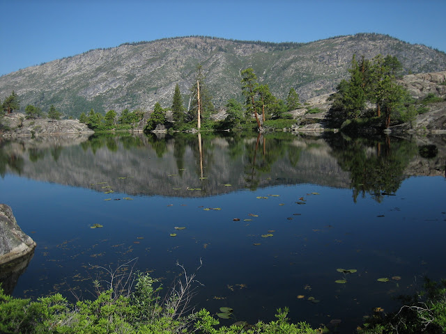
Dried up little pond we passed by when we hit the canyon floor. Dry year.

Ah! The Tuolumne!

Beautiful. We stopped for a bit to have lunch, swim/bathe, and do laundry. Love Sierra waters.

Ayuh. We followed the river more or less as we made our way into Pate Valley.

Hiking through Pate, we came to this one beachy area of the river that was just ethereal. Just superb. I could easily have spent a day or two in the area lounging in the river and exploring. Had I more time, I would have done a day trip up to Pleasant Valley and the Table Lake area.

No eden is complete without a serpent.

Wow.

Wow.

Wow.

We did not camp in Pate on this trip, and neither of us were keen on the reputation Pate has for particularly active bears. I want a good night's sleep, thanks. So, we moseyed along. Next time, I'll do at least a night or two in Pate so I can take day hikes from it, explore things I missed this time around.

Split Tuolumne rejoining itself.

The hike through Pate turned into a bit of hot slog. As the day grew, the heat really started beating on us. Probably a factor of both the overall weather and the low elevation (we're about 4k' lower from yesterday). And the shaded sections of Pate were mosquito turf (though mosquitoes weren't that bad on this trip at all, with the dry year...not nearly as bad as they can be in the Sierra).

The river was always available if we really needed to cool off, though we never really took advantage, preferring to lounge at camp later.

Nearly to our second campsite, down at the edge of the forested section here and at the base of the slope.

Ray, looking forward to the end of the hot slog.

At camp, we were gifted this awesome cascade, almost mini-waterwheel-esque.

The river playfully rushed down this worn slope to feed this nice little swimming hole. On this slope was the most awesome little clean granite pool, fed and drained off the side of the main cascade. It was PERFECT for cooling off, getting water, bathing, etc. Didn't get a shot that really did it justice, on this day at least.

The next pool over, this guy was basking. Plenty of room for everyone.

"Good heavens, sir, I daresay I've been subjected to enough impropriety for one day!" Sorry, my good fellow, bathing at the end of a hot hike always feels so good...

Little fall above the cascade, quite a deep looking pool there.

View down the cascade.

Canyon walls and peaks fronting our camp.

Sun is setting. Time for dinner and other camp chores.

All ready...

All that was left was to enjoy the setting sun lighting up the walls (Colby Mountain here).

Day 3 comin.
Heading down to Pate Valley and camping a couple of miles beyond, below 5352T...
After a restful sleep, woke up at dawn to watch the sun rise over the canyon.
Getting there... (iphone pic)
Ray opted to catch a few more zzz's...
I chilled on a nice boulder and enjoyed daybreak.
A little lighter... (iphone pic)
Almost there...
Ah!
w00t w00t.
Nothing quite as cheery as the morning sun.
Morrison Creek running behind our camp. More of a trickle, but it was good enough. After having breakfast, getting some water, and breaking camp, Ray and I continued down to Pate Valley.
Views of the area Piute Creek runs though started peeking through as we made our way down.
Zoom.
Great scenery abounds right on the trail as well.
Soon enough, we start getting magnificent views of Pate Valley and up-canyon.
This was taken near the area we were aiming to camp at the night before. We would have had spectacular views of Hetch Hetchy as well as up-canyon.
Zoom, backside of Hetch Hetchy.
This is the actual area; we're checking out the top of this knob that would have been amazing to camp on.
Never ceases to amaze when I see the precarious positions some of these erratics live in...
Well, we didn't get to camp here, but we sure as hell made it a point to enjoy a nice snack and break here.
Reluctantly, we continued down.
Definitely need to pay constant attention to foot placement on the way down to Pate.
Getting closer to Pate Valley.
Dried up little pond we passed by when we hit the canyon floor. Dry year.
Ah! The Tuolumne!
Beautiful. We stopped for a bit to have lunch, swim/bathe, and do laundry. Love Sierra waters.
Ayuh. We followed the river more or less as we made our way into Pate Valley.
Hiking through Pate, we came to this one beachy area of the river that was just ethereal. Just superb. I could easily have spent a day or two in the area lounging in the river and exploring. Had I more time, I would have done a day trip up to Pleasant Valley and the Table Lake area.
No eden is complete without a serpent.
Wow.
Wow.
Wow.
We did not camp in Pate on this trip, and neither of us were keen on the reputation Pate has for particularly active bears. I want a good night's sleep, thanks
. So, we moseyed along. Next time, I'll do at least a night or two in Pate so I can take day hikes from it, explore things I missed this time around.Split Tuolumne rejoining itself.
The hike through Pate turned into a bit of hot slog. As the day grew, the heat really started beating on us. Probably a factor of both the overall weather and the low elevation (we're about 4k' lower from yesterday). And the shaded sections of Pate were mosquito turf (though mosquitoes weren't that bad on this trip at all, with the dry year...not nearly as bad as they can be in the Sierra).
The river was always available if we really needed to cool off, though we never really took advantage, preferring to lounge at camp later.
Nearly to our second campsite, down at the edge of the forested section here and at the base of the slope.
Ray, looking forward to the end of the hot slog.
At camp, we were gifted this awesome cascade, almost mini-waterwheel-esque.
The river playfully rushed down this worn slope to feed this nice little swimming hole. On this slope was the most awesome little clean granite pool, fed and drained off the side of the main cascade. It was PERFECT for cooling off, getting water, bathing, etc. Didn't get a shot that really did it justice, on this day at least.
The next pool over, this guy was basking. Plenty of room for everyone
."Good heavens, sir, I daresay I've been subjected to enough impropriety for one day!" Sorry, my good fellow, bathing at the end of a hot hike always feels so good...
Little fall above the cascade, quite a deep looking pool there.
View down the cascade.
Canyon walls and peaks fronting our camp.
Sun is setting. Time for dinner and other camp chores.
All ready...
All that was left was to enjoy the setting sun lighting up the walls (Colby Mountain here).
Day 3 comin.
|
Re: White Wolf to Tuolumne Meadows via GCT - seeking advice and suggestions July 30, 2013 10:36PM | Registered: 10 years ago Posts: 144 |
Grand Canyon of the Tuolumne Trip - Yosemite NP - Day 3
From campsite near cascade below 5352T to campsite on dome above Muir Gorge.
Dawn, baby! Always something I relish. I feel as if I pick up the string of the world and see, hear, feel the vibrations of existence. It's confirmation that the world turns, and that I turn with it.

Have a hard time staying in the shelter at sunrise. Had to get out and poke around the cascade in the ephemeral glow.

Looking down the cascade into the pool at the bottom.

Dynamic.

I feel a kinship with the river; it passes on coffee.

Sunlight descending into the canyon.

Went a few more paces up-river and came across a lovely and spirited little fall.


Cool.

Had to sit by the fall and just chill for a while, feel the world stir.


Continually impressed with all the footholds life finds.

Boom!

Ray got out of bed in time to enjoy the last bit of the early morning. That little pool you see there, just to the right of the main cascade, right past Ray, was the best for lounging, getting water, washing, whatever. We spent a good bit of the morning being lazy in or around it, especially as the day started warming.

I brought him up to the little fall.


Kinda reminds me of the prismatic hot springs in Yellowstone. But this water definitely isn't hot

Basking after the night.

Enjoyable little cascade. We stuck around for a bit to soak up the sun for a little as it started to fill the canyon.

The lazy clouds cast dappled morning light on the surrounding canyon walls and peaks. Eventually, we hit the trail again.

Beautiful. Of course, these meager pics don't do it justice, sorry . Looking back SW along the canyon.

View south.

SW view further along the trail.

Heading east on the trail.

More ethereal scenery.

Don't know if photobucket offers enough quality, but, where's Waldo? We're almost to Register Creek and Muir Gorge here.

My first glimpse of the Muir Gorge. This is pretty much right above the confluence of the Tuolumne with Register Creek and the creek that comes through Rodgers Canyon.

Zoom.

Different angle from a little farther along the trail. My plan was to traverse Muir Gorge coming down river (since it's a dry year), but I wanted to check the outlet at the west and down-river end of the gorge to make sure I could get out (I wanted to verify that I wouldn't be jumping into a bowl I couldn't get out of). (Thank you so much, Chick-on, for the great idea!)

Views SW along the river, taken from the crossing of Rodgers Canyon creek. Ray took a break here, so I reconnoitered ahead to scout the way down to the west end of Muir Gorge.

I was so focused on getting to the off-trail scout, that when I turned a corner on the trail, BAM!, I was hit with the most spectacular surprise at the Register Creek crossing. There are few times when I've actually sucked in a breath in surprise, and this was one. Check out this freaking grotto! Mountain creek falling gently (this year) into an emerald pool, the clarity of which strikes a crystal note in one's soul.

Let's take a closer look shall we?

This is the stuff of myth, legend, Tolkeinesque reverie. I half expected a magical door on the other end of the pool... surely such a mystical grotto is the foyer to some world of incomprehensible beauty...

You know I had to swim in it. Anyone read the Hyperion Cantos by Dan Simmons? I imagined this would be the baptism for Templars, those worshipers of Muir. Oh, let me tell you, it was one frigid baptism

See, I am already one with nature, beloved by all. Bwahhaahah After the swim and standing in the Register Creek fall, it was time to move on and scout out the west end of Muir Gorge.

Wait a minute, let's take a look at it again, shall we? You can't leave a place like this without long, lingering, looks. Ok. Had enough? If so, let's continue on. If not, you're welcome to stay a bit

So, I left Ray to chill at the magical grotto, and I rambled down to the western terminus of Muir Gorge. Here we are... now to see if I can find the big pool I'd have to swim.

Further in.

After a short jaunt, I was brought to a halt because I had run out of dry boulders to hop. I had my camera on me and wasn't set up to get wet with confidence (d'oh). I had anticipated being able to scramble out of the water all the way to the pool, silly me. Should have gotten equipped for a dunking before going down. Oh well.

A little bit farther, can peek a little further up the gorge. (I know this picture is pretty much the same as the last one. Too bad :p) Seeing as it was already getting a bit late in the day, I decided to shelve the Gorge exploration until tomorrow morning, fit it into our schedule somehow. In retrospect, I should have just gone back up to the trail and rejoined Ray, geared up for immersion, then gone back down to fully scout all the way to the pool since the rest of the day would be just getting to and chilling at camp on the dome above the gorge.

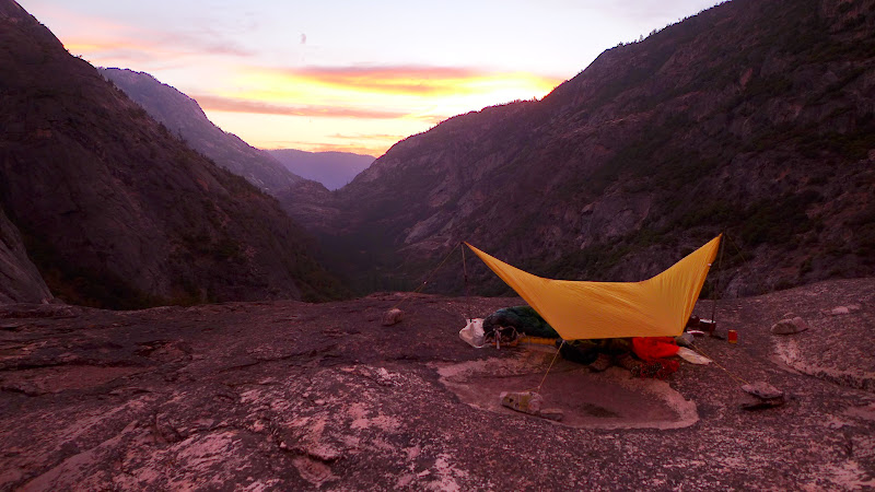
I rejoined Ray, then we loaded up on water at Register Creek since camping up on the dome above the gorge would be a dry camp. Situations like that is why I carry a 2L evernew bladder and 2x1L bottles. Here's Ray gettin topside on the dome.

View north from the top of the dome.

Grand Mtn. really is grand! Eastern end of Muir Gorge area is visible.

Zoom. Water level looks doable, but it's still iffy solo. The rocks are slippery, and it's very easy to twist/break something. Easy enough when you're boulder hopping dry stuff, but sometimes it looked like there was no other option but to go down some little fall, which can be sketchy at best. It's ok here, but getting closer to the gorge (not pictured) presented a few sketchier areas. I decided I'd just attempt to get to the big pool from up-river tomorrow morning when the sun got into the gorge (for some warmth), and decide then on whether or not I wanted to take a gamble on swimming through to the west end without having verified a safe-outlet myself.

So, for the rest of the afternoon, there was nothing left but to chill out, take in the views. Grand Mountain, again, to our southeast.

Colby Mountain, to our southwest.

Looking north to wall separating the grand canyon from Rodgers Canyon.

View east back along the river, whence we came.

My attempt to get the Milky Way with the pitiful sensor and optics on my P&S. Exercise in futility, I know. I can get an impression of it if I mess with the display of the image, but, here are some stars :p

Ray opted to sleep out in his bag this night since mosquitoes weren't a problem up on the relatively windy dome. I wanted to get more practice setting up my duomid with rock anchors in a windy spot. I didn't find enough easily movable rocks that weighed enough to keep tarp taut in wind. As a result, I woke pretty early in the morning to a good bit of flapping since the wind had loaded the tarp sides and moved my anchors. I suspected that would happen to some extent given the number and mass of the rocks I used, but I hadn't thought it would be as annoying as it became. So, experience gained for next time: put in effort to move heavy rocks, or use deadmen anchors with good size piles of rocks. One can never be lazy if one wants a good night's sleep...

Next couple of days comin tomorrow.
From campsite near cascade below 5352T to campsite on dome above Muir Gorge.
Dawn, baby! Always something I relish. I feel as if I pick up the string of the world and see, hear, feel the vibrations of existence. It's confirmation that the world turns, and that I turn with it.
Have a hard time staying in the shelter at sunrise. Had to get out and poke around the cascade in the ephemeral glow.
Looking down the cascade into the pool at the bottom.
Dynamic.
I feel a kinship with the river; it passes on coffee.
Sunlight descending into the canyon.
Went a few more paces up-river and came across a lovely and spirited little fall.
Cool.
Had to sit by the fall and just chill for a while, feel the world stir.
Continually impressed with all the footholds life finds.
Boom!
Ray got out of bed in time to enjoy the last bit of the early morning. That little pool you see there, just to the right of the main cascade, right past Ray, was the best for lounging, getting water, washing, whatever. We spent a good bit of the morning being lazy in or around it, especially as the day started warming.
I brought him up to the little fall.
Kinda reminds me of the prismatic hot springs in Yellowstone. But this water definitely isn't hot
Basking after the night.
Enjoyable little cascade. We stuck around for a bit to soak up the sun for a little as it started to fill the canyon.
The lazy clouds cast dappled morning light on the surrounding canyon walls and peaks. Eventually, we hit the trail again.
Beautiful. Of course, these meager pics don't do it justice, sorry
. Looking back SW along the canyon.View south.
SW view further along the trail.
Heading east on the trail.
More ethereal scenery.
Don't know if photobucket offers enough quality, but, where's Waldo? We're almost to Register Creek and Muir Gorge here.
My first glimpse of the Muir Gorge. This is pretty much right above the confluence of the Tuolumne with Register Creek and the creek that comes through Rodgers Canyon.
Zoom.
Different angle from a little farther along the trail. My plan was to traverse Muir Gorge coming down river (since it's a dry year), but I wanted to check the outlet at the west and down-river end of the gorge to make sure I could get out (I wanted to verify that I wouldn't be jumping into a bowl I couldn't get out of). (Thank you so much, Chick-on, for the great idea!)
Views SW along the river, taken from the crossing of Rodgers Canyon creek. Ray took a break here, so I reconnoitered ahead to scout the way down to the west end of Muir Gorge.
I was so focused on getting to the off-trail scout, that when I turned a corner on the trail, BAM!, I was hit with the most spectacular surprise at the Register Creek crossing. There are few times when I've actually sucked in a breath in surprise, and this was one. Check out this freaking grotto! Mountain creek falling gently (this year) into an emerald pool, the clarity of which strikes a crystal note in one's soul.
Let's take a closer look shall we?
This is the stuff of myth, legend, Tolkeinesque reverie. I half expected a magical door on the other end of the pool... surely such a mystical grotto is the foyer to some world of incomprehensible beauty...
You know I had to swim in it. Anyone read the Hyperion Cantos by Dan Simmons? I imagined this would be the baptism for Templars, those worshipers of Muir. Oh, let me tell you, it was one frigid baptism
See, I am already one with nature, beloved by all. Bwahhaahah
After the swim and standing in the Register Creek fall, it was time to move on and scout out the west end of Muir Gorge.Wait a minute, let's take a look at it again, shall we? You can't leave a place like this without long, lingering, looks. Ok. Had enough? If so, let's continue on. If not, you're welcome to stay a bit
So, I left Ray to chill at the magical grotto, and I rambled down to the western terminus of Muir Gorge. Here we are... now to see if I can find the big pool I'd have to swim.
Further in.
After a short jaunt, I was brought to a halt because I had run out of dry boulders to hop. I had my camera on me and wasn't set up to get wet with confidence (d'oh). I had anticipated being able to scramble out of the water all the way to the pool, silly me. Should have gotten equipped for a dunking before going down. Oh well.
A little bit farther, can peek a little further up the gorge. (I know this picture is pretty much the same as the last one. Too bad :p) Seeing as it was already getting a bit late in the day, I decided to shelve the Gorge exploration until tomorrow morning, fit it into our schedule somehow. In retrospect, I should have just gone back up to the trail and rejoined Ray, geared up for immersion, then gone back down to fully scout all the way to the pool since the rest of the day would be just getting to and chilling at camp on the dome above the gorge.
I rejoined Ray, then we loaded up on water at Register Creek since camping up on the dome above the gorge would be a dry camp. Situations like that is why I carry a 2L evernew bladder and 2x1L bottles. Here's Ray gettin topside on the dome.
View north from the top of the dome.
Grand Mtn. really is grand! Eastern end of Muir Gorge area is visible.
Zoom. Water level looks doable, but it's still iffy solo. The rocks are slippery, and it's very easy to twist/break something. Easy enough when you're boulder hopping dry stuff, but sometimes it looked like there was no other option but to go down some little fall, which can be sketchy at best. It's ok here, but getting closer to the gorge (not pictured) presented a few sketchier areas. I decided I'd just attempt to get to the big pool from up-river tomorrow morning when the sun got into the gorge (for some warmth), and decide then on whether or not I wanted to take a gamble on swimming through to the west end without having verified a safe-outlet myself.
So, for the rest of the afternoon, there was nothing left but to chill out, take in the views. Grand Mountain, again, to our southeast.
Colby Mountain, to our southwest.
Looking north to wall separating the grand canyon from Rodgers Canyon.
View east back along the river, whence we came.
My attempt to get the Milky Way with the pitiful sensor and optics on my P&S. Exercise in futility, I know. I can get an impression of it if I mess with the display of the image, but, here are some stars :p
Ray opted to sleep out in his bag this night since mosquitoes weren't a problem up on the relatively windy dome. I wanted to get more practice setting up my duomid with rock anchors in a windy spot. I didn't find enough easily movable rocks that weighed enough to keep tarp taut in wind. As a result, I woke pretty early in the morning to a good bit of flapping since the wind had loaded the tarp sides and moved my anchors. I suspected that would happen to some extent given the number and mass of the rocks I used, but I hadn't thought it would be as annoying as it became. So, experience gained for next time: put in effort to move heavy rocks, or use deadmen anchors with good size piles of rocks. One can never be lazy if one wants a good night's sleep...
Next couple of days comin tomorrow.
July 31, 2013 07:12AM | Moderator Registered: 15 years ago Posts: 1,876 |
|
Re: White Wolf to Tuolumne Meadows via GCT - seeking advice and suggestions July 31, 2013 07:28AM | Registered: 10 years ago Posts: 144 |
Quote
tomdisco
Thanks very much for posting photos of your hike. Loved the mystical grotto--neglected to check that out 2 years ago when passing by. Wow! Have not seen an external frame backpack in years.
Glad you enjoyed the pictures, Tom!
As for the old external, yeah, Ray kept telling me the whole trip how his pack was older than I am (literally). It's been a lot of places around the world with him! Says something that it's still going strong after all these years. He cut out an internal divider to provide more useable space inside, worked well (in fact, canister ended up inside midway during the trip, he couldn't keep it tied on the frame externally).
More pics comin soon.
July 31, 2013 07:35AM | Moderator Registered: 14 years ago Posts: 7,421 |
Tanks for reporting back. Pretty sure I did mention it was a wee bit windy atop
that dome you slept on. On my Muir Gorge trip last year setup shop there on
day 1 in and eventually awoke during the night and said "this sucks" and
prompltly packed up and move down to the east out of the wind. It's there
that the bear stole my Archos vid player and Neo Air while I did the Gorge.
It was a nice site though... from that trip on... I just take the SoloMid.
If I had that I wouldn't have moved. It does incredible in the wind.
MSR eWing... not as well unless pitch it different that this:
And setup in the wind... painful. MLD SoloMid is the way to go for me now.
|
Re: White Wolf to Tuolumne Meadows via GCT - seeking advice and suggestions July 31, 2013 08:09AM | Registered: 10 years ago Posts: 144 |
Quote
chick-on
Tanks for reporting back. Pretty sure I did mention it was a wee bit windy atop
that dome you slept on. On my Muir Gorge trip last year setup shop there on
day 1 in and eventually awoke during the night and said "this sucks" and
prompltly packed up and move down to the east out of the wind. It's there
that the bear stole my Archos vid player and Neo Air while I did the Gorge.
It was a nice site though... from that trip on... I just take the SoloMid.
If I had that I wouldn't have moved. It does incredible in the wind.
MSR eWing... not as well unless pitch it different that this:
And setup in the wind... painful. MLD SoloMid is the way to go for me now.
Yeah, you did, I was just lazy in gathering rocks up there. It was getting dark by the time we actually started setting up for the night up there. I knew the wind would pick up at night, I was just being stupid
The Duomid handles wind fine, especially if I can stake low and tight and use the center panel tie-outs to help out (only to minimize flapping, as you know). A good friend of mine has the Solo, and while it may perform a tiny bit better in wind simply because of the lower profile, I prefer the duomid for more room in wet weather and space for my GF when she's along. I just wish I could score an OookWorks OookNest Nano to replace the Solo Innernet; I'm not crazy about how the solo inner fits the duomid. It works, but it works as an afterthought; the design/fit is really optimized for use under a Solomid.
Edited 1 time(s). Last edit at 07/31/2013 08:12AM by HikingMano.
|
Re: White Wolf to Tuolumne Meadows via GCT - seeking advice and suggestions July 31, 2013 09:07AM | Registered: 10 years ago Posts: 144 |
Side note regarding Mids: I still want to get a solomid, so I have the option of a smaller, strictly solo, shelter when I'm not expecting rain (like this trip). It'd be more to keep the wind off, but it'd still be absolutely functional, if not roomy, in rain. Leaning towards a sil Solo for the kind of conditions I'd use it in (dry and windy).
|
Re: White Wolf to Tuolumne Meadows via GCT - seeking advice and suggestions July 31, 2013 08:23AM | Registered: 10 years ago Posts: 115 |
|
Re: White Wolf to Tuolumne Meadows via GCT - seeking advice and suggestions July 31, 2013 08:56AM | Registered: 10 years ago Posts: 144 |
Quote
atomicmonkey
Chick-on, great picture! I would love to ditch my heavy 2 piece tent and go with something like the MLD solomid. One question though, if it rains, do you still get soaked from the ground water? Sorry for the idiot question, I just can't seem to figure it out.
Not to speak for chick-on, but commenting from my own experience with regular and shaped tarps, if you have a bathtub floor inner or just a bathtub floor groundsheet, you can get away with poor site selection somewhat. If you're just using a flat groundsheet, adequate coverage overhead from rain and wind-driven rain will work on ground that can absorb water. Otherwise, don't set up shop in a drainage or depression if you expect rain.
July 31, 2013 09:24PM | Moderator Registered: 14 years ago Posts: 7,421 |
Quote
HikingMano
Quote
atomicmonkey
Chick-on, great picture! I would love to ditch my heavy 2 piece tent and go with something like the MLD solomid. One question though, if it rains, do you still get soaked from the ground water? Sorry for the idiot question, I just can't seem to figure it out.
Not to speak for chick-on, but commenting from my own experience with regular and shaped tarps, if you have a bathtub floor inner or just a bathtub floor groundsheet, you can get away with poor site selection somewhat. If you're just using a flat groundsheet, adequate coverage overhead from rain and wind-driven rain will work on ground that can absorb water. Otherwise, don't set up shop in a drainage or depression if you expect rain.
Speak away. Sounds good. I use the bathtub floor in the winter along with a Alpine Bivy.
Non-snow conditions I go with the polypro 2oz. ground cloth and a UL Bivy to protect from
any spindrift and keep my sleeping bag nice and dry.
Of course just sleeping under the stars is the preferred method.
|
Re: White Wolf to Tuolumne Meadows via GCT - seeking advice and suggestions July 31, 2013 10:18PM | Registered: 10 years ago Posts: 144 |
Quote
chick-on
Speak away. Sounds good. I use the bathtub floor in the winter along with a Alpine Bivy.
Non-snow conditions I go with the polypro 2oz. ground cloth and a UL Bivy to protect from
any spindrift and keep my sleeping bag nice and dry.
Of course just sleeping under the stars is the preferred method.
Ugh, the MLD superlight Bivy is the other piece of shelter kit I've been lusting after. Haven't actually spent a night in a bivy yet. I like the idea, especially for use with my quilt, but I do like the room in a net inner when it's buggy out. Also worried about condensation, but won't know until I try one out myself.
I go back and forth on Polycro vs. Tyvek, went with polycryo on this trip since I had my inner along with its shield silnylon floor. When the bugs are gone and I don't need the net, I'll probably go back to tyvek.
Sleeping under the stars is vastly preferred
Day 3 was my last night under a Mid, cowboy camped it the other nights.Rest of pics comin later tonight or tomorrow.
BTW, I thought you might have been the person, or one of the people, chick-on, to sleep up there on the tippy top of the dome overlooking west down-canyon.
Found the rocks. Figured it would have been too windy up there and there wasn't enough room for my buddy and me, so we camped a little lower on the east side of the dome.Edited 1 time(s). Last edit at 07/31/2013 10:21PM by HikingMano.
|
Re: White Wolf to Tuolumne Meadows via GCT - seeking advice and suggestions August 01, 2013 03:47PM | Registered: 11 years ago Posts: 24 |
Quote
chick-on
Tanks for reporting back. Pretty sure I did mention it was a wee bit windy atop
that dome you slept on. On my Muir Gorge trip last year setup shop there on
day 1 in and eventually awoke during the night and said "this sucks" and
prompltly packed up and move down to the east out of the wind. It's there
that the bear stole my Archos vid player and Neo Air while I did the Gorge.
It was a nice site though... from that trip on... I just take the SoloMid.
If I had that I wouldn't have moved. It does incredible in the wind.
MSR eWing... not as well unless pitch it different that this:
And setup in the wind... painful. MLD SoloMid is the way to go for me now.
Looks kinda like a stealth fighter coming in for a landing.
July 31, 2013 11:35AM | Registered: 12 years ago Posts: 578 |
|
Re: White Wolf to Tuolumne Meadows via GCT - seeking advice and suggestions July 31, 2013 02:31PM | Registered: 10 years ago Posts: 144 |
July 31, 2013 12:21PM | Registered: 11 years ago Posts: 308 |
|
Re: White Wolf to Tuolumne Meadows via GCT - seeking advice and suggestions July 31, 2013 11:01PM | Registered: 10 years ago Posts: 144 |
Grand Canyon of the Tuolumne Trip - Yosemite NP - Day 4
From dome above Muir Gorge to Cathedral Creek confluence.
After a not so great night of sleep up on the dome (I should have just slept out rather than pitched the duomid half-assed), Ray and I continued up the canyon. To start the morning off right, we had to do somewhere around 400' in around a third of a mile to switchback up and over the spur east of the dome which also forms part of Muir Gorge. That'll wake you up At least the views were nice once we got to the top. Here's Ray looking back at the dome we camped on.

Grand Mtn in the morning light. Rugged beast.

Once we climbed the switchbacks, Ray and I scrambled around on top of that knob, trying to get more views of Muir Gorge, so I could judge whether or not I still wanted to attempt it this morning. Looked doable, maybe iffy in some parts. I decided I'd just give it a go, at least get down to big pool I'd have to swim, then decide what I wanted to do from there. Since we had to make our next camp that day, I decided I'd set a deadline time for the gorge attempt and just see how it goes. If I made it to the pool by the deadline, I'd go through. If not, then the deadline would be my turn-around time.

Making our way back down to the river after climbing over the spur. Morning streaming through the canyon.

This is where we decided Ray would hang out and relax while I attempted the gorge traverse. This is near the confluence with the drainage from Ten Lakes.

C'mon sun! I didn't want to freeze while doing the gorge, wanted the sun to light up the joint before I ventured forth.

After breakfast, some chilling waiting for the sun to rise a bit more for warmth, and getting my stuff prepped for a swim, I finally got moving down the river. I had my camera in a aloksak and drybag and I didn't really want to dig it out very often. Plus, by this point, I think I had already ran one battery dry and was on my spare. Started being very picky about taking pics since I wanted my spare to last through to the end of the trip. Anyway, this is the view nearing the drainage of Ten Lakes, with Colby Moutain standing proud.

There was a really nice swimming hole near where I would have popped into the river had I done it the day before.

After a bit of scrambling fun, I neared my deadline and decided to call it quits. This is as close as I got to the gorge. I knew getting down to it would put me past my deadline, and I didn't want to fall prey to the "it's just right there!" temptation. Easy to rush and make mistakes when you get into that mindset, and it would put us too far behind schedule for getting to the next spot I had planned for the night's camp.
So, regrettably, I turned around and went back. If I had another equally capable person doing it with me, wouldn't have been a question. May even make it back this Sept. with just such a person. As it was, I didn't want to ditch Ray for too long or have him worry too much if I took longer than expected. There will be other dry years, and going later in the fall may work as well even if water levels are normal. Next time! As it was, I had a blast poking around in the gorge area, east and west ends.

Anyway, so that was that. I met back up with Ray, who had a pleasant time chilling by the river, and we continued up the canyon to our next campsite.

There were some awesome swimming holes along the way. It was getting quite hot and they were so tempting...


Here we are! Cathedral Creek visible. It was a spectacular area, probably my favorite campsite of the entire trip. Unfortunately I was trying to conserve battery power and didn't take many pics, but they wouldn't do the spot justice anyway.

Not only did the place have gorgeous views, but MAN, it had the MOST INCREDIBLE swimming hole, complete with waterfall. Words can not describe how utterly paradisiacal this spot was. One of my favorite places from the trip, just superb. And it was even more awesome that we had it to ourselves the entire time we were there.

Aaaaahhhhh.... soooo good on a hot day.

Sooo goooood....

Ray got comfy in some shade and took a nap.

After enjoying the water for quite a bit, we got set up for the night and did the normal camp chores.

Got to watch the sun lighting up the peaks as the sun went down (iphone).

Since there was a fire ring already established in the spot and Ray was hankering for some of the old camping ambiance remembered from his youth to go along with his scotch, I gathered some driftwood and got us a lil campfire going. I'm pretty LNT for the most part, and I don't make fires when out bping, but it was definitely nice to enjoy a fire-lit camp. There's something to be said for watching flickering flames and appreciating the natural surroundings in good company. I know Ray certainly enjoyed it, with Scotch in-hand I figured our impact was minimal, using an established ring, driftwood from the river, and keeping it small. Of course, we were responsible and put it out thoroughly after. Can't say the same for another camp we ran across the next day, where others had left hot ashes/embers and a smoldering log in their pit... Baffled by the ignorance and incompetence...
Anyway, we had a blast that night lying abed looking at the milky way, arguing about constellations, and watching for shooting stars and satellites. Really the best campsite of the entire trip.

Now, onto Day 5... won't take me much longer to finish; there are less pics as the days go on (due to battery life attrition).
From dome above Muir Gorge to Cathedral Creek confluence.
After a not so great night of sleep up on the dome (I should have just slept out rather than pitched the duomid half-assed), Ray and I continued up the canyon. To start the morning off right, we had to do somewhere around 400' in around a third of a mile to switchback up and over the spur east of the dome which also forms part of Muir Gorge. That'll wake you up
At least the views were nice once we got to the top. Here's Ray looking back at the dome we camped on.Grand Mtn in the morning light. Rugged beast.
Once we climbed the switchbacks, Ray and I scrambled around on top of that knob, trying to get more views of Muir Gorge, so I could judge whether or not I still wanted to attempt it this morning. Looked doable, maybe iffy in some parts. I decided I'd just give it a go, at least get down to big pool I'd have to swim, then decide what I wanted to do from there. Since we had to make our next camp that day, I decided I'd set a deadline time for the gorge attempt and just see how it goes. If I made it to the pool by the deadline, I'd go through. If not, then the deadline would be my turn-around time.
Making our way back down to the river after climbing over the spur. Morning streaming through the canyon.
This is where we decided Ray would hang out and relax while I attempted the gorge traverse. This is near the confluence with the drainage from Ten Lakes.
C'mon sun! I didn't want to freeze while doing the gorge, wanted the sun to light up the joint before I ventured forth.
After breakfast, some chilling waiting for the sun to rise a bit more for warmth, and getting my stuff prepped for a swim, I finally got moving down the river. I had my camera in a aloksak and drybag and I didn't really want to dig it out very often. Plus, by this point, I think I had already ran one battery dry and was on my spare. Started being very picky about taking pics since I wanted my spare to last through to the end of the trip. Anyway, this is the view nearing the drainage of Ten Lakes, with Colby Moutain standing proud.
There was a really nice swimming hole near where I would have popped into the river had I done it the day before.
After a bit of scrambling fun, I neared my deadline and decided to call it quits. This is as close as I got to the gorge. I knew getting down to it would put me past my deadline, and I didn't want to fall prey to the "it's just right there!" temptation. Easy to rush and make mistakes when you get into that mindset, and it would put us too far behind schedule for getting to the next spot I had planned for the night's camp.
So, regrettably, I turned around and went back. If I had another equally capable person doing it with me, wouldn't have been a question. May even make it back this Sept. with just such a person. As it was, I didn't want to ditch Ray for too long or have him worry too much if I took longer than expected. There will be other dry years, and going later in the fall may work as well even if water levels are normal. Next time! As it was, I had a blast poking around in the gorge area, east and west ends.
Anyway, so that was that. I met back up with Ray, who had a pleasant time chilling by the river, and we continued up the canyon to our next campsite.
There were some awesome swimming holes along the way. It was getting quite hot and they were so tempting...
Here we are! Cathedral Creek visible. It was a spectacular area, probably my favorite campsite of the entire trip. Unfortunately I was trying to conserve battery power and didn't take many pics, but they wouldn't do the spot justice anyway.
Not only did the place have gorgeous views, but MAN, it had the MOST INCREDIBLE swimming hole, complete with waterfall. Words can not describe how utterly paradisiacal this spot was. One of my favorite places from the trip, just superb. And it was even more awesome that we had it to ourselves the entire time we were there.
Aaaaahhhhh.... soooo good on a hot day.
Sooo goooood....
Ray got comfy in some shade and took a nap.
After enjoying the water for quite a bit, we got set up for the night and did the normal camp chores.
Got to watch the sun lighting up the peaks as the sun went down (iphone).
Since there was a fire ring already established in the spot and Ray was hankering for some of the old camping ambiance remembered from his youth to go along with his scotch, I gathered some driftwood and got us a lil campfire going. I'm pretty LNT for the most part, and I don't make fires when out bping, but it was definitely nice to enjoy a fire-lit camp. There's something to be said for watching flickering flames and appreciating the natural surroundings in good company. I know Ray certainly enjoyed it, with Scotch in-hand
I figured our impact was minimal, using an established ring, driftwood from the river, and keeping it small. Of course, we were responsible and put it out thoroughly after. Can't say the same for another camp we ran across the next day, where others had left hot ashes/embers and a smoldering log in their pit... Baffled by the ignorance and incompetence...Anyway, we had a blast that night lying abed looking at the milky way, arguing about constellations, and watching for shooting stars and satellites. Really the best campsite of the entire trip.
Now, onto Day 5... won't take me much longer to finish; there are less pics as the days go on (due to battery life attrition).
|
Re: White Wolf to Tuolumne Meadows via GCT - seeking advice and suggestions July 31, 2013 11:06PM | Registered: 10 years ago Posts: 144 |
Grand Canyon of the Tuolumne Trip - Yosemite NP - Day 5
Cathedral Creek to just past Le Conte Falls.
Rise and shine!

Ray and I hit the trail and continued up-canyon. Here we are at the Return Creek crossing. Beautiful creek.

Confluence, Toulumne coming in from the left.

Trekkin along, heading up towards the famous GCT waterfalls now.


A view back down the canyon as we ascend. We came from behind the bend that is the east end of Falls Ridge, on the left.

At last! What Ray and I had made the trip to see, the famous Waterwheel Falls! We knew it wouldn't really be going off this year, with the low snow-pack, but we knew there'd still be a little flow. Falls Ridge in the background.

Ray reaching his goal for this trip.

Well, not waterwheelin, but still pretty damn impressive. I can only imagine what it's like when it's really raging...


View down the falls as it runs down the canyon. Ray and I hung out here for a while, having lunch, exploring, napping. A roaring waterfall is very soothing...


The pool directly upriver of Waterwheel Falls.

After we got our fill of Waterwheel, we proceeded to Le Conte.

Approaching Le Conte.

Ray taking his shots.

Le Conte. Impressive in its own way. Sorry for the crappy pics this day, didn't spend much time fiddling with the camera.

Little waterwheel spot in Le Conte.

After Le Conte, we continued a little ways up-river to our next campsite.

Here we are, exploring our campsite for the night. The TR ran right by this one too.

We even had a nice little fall to enjoy.

View down-river from our camp.

Cool spot with some nice flowing pools off the main river.

Bath spot!

Explored up along the river a bit.

Looking back towards camp.


Our camp pet for the night.

Pretty good size little guy, and a chill fellow.

After taking a little swim/bath, laundry, and putzing around the area, I got set up for the night before getting on dinner.

Ray getting his stuff ready. Our second and last fire of the trip; Ray just had to earn his merit badge and finish the last of this scotch :p

We got to watch the sun set as the moon made its way across the evening sky. Another great night for stargazing, though it did get a little windy in the night. Got chilly enough I actually had to put my windshirt on under my quilt and use my buff as a balaclava. (iPhone)

Day 6 comin.
Edited 1 time(s). Last edit at 07/31/2013 11:09PM by HikingMano.
Cathedral Creek to just past Le Conte Falls.
Rise and shine!
Ray and I hit the trail and continued up-canyon. Here we are at the Return Creek crossing. Beautiful creek.
Confluence, Toulumne coming in from the left.
Trekkin along, heading up towards the famous GCT waterfalls now.
A view back down the canyon as we ascend. We came from behind the bend that is the east end of Falls Ridge, on the left.
At last! What Ray and I had made the trip to see, the famous Waterwheel Falls! We knew it wouldn't really be going off this year, with the low snow-pack, but we knew there'd still be a little flow. Falls Ridge in the background.
Ray reaching his goal for this trip.
Well, not waterwheelin, but still pretty damn impressive. I can only imagine what it's like when it's really raging...
View down the falls as it runs down the canyon. Ray and I hung out here for a while, having lunch, exploring, napping. A roaring waterfall is very soothing...
The pool directly upriver of Waterwheel Falls.
After we got our fill of Waterwheel, we proceeded to Le Conte.
Approaching Le Conte.
Ray taking his shots.
Le Conte. Impressive in its own way. Sorry for the crappy pics this day, didn't spend much time fiddling with the camera.
Little waterwheel spot in Le Conte.
After Le Conte, we continued a little ways up-river to our next campsite.
Here we are, exploring our campsite for the night. The TR ran right by this one too.
We even had a nice little fall to enjoy.
View down-river from our camp.
Cool spot with some nice flowing pools off the main river.
Bath spot!
Explored up along the river a bit.
Looking back towards camp.
Our camp pet for the night.
Pretty good size little guy, and a chill fellow.
After taking a little swim/bath, laundry, and putzing around the area, I got set up for the night before getting on dinner.
Ray getting his stuff ready. Our second and last fire of the trip; Ray just had to earn his merit badge and finish the last of this scotch :p
We got to watch the sun set as the moon made its way across the evening sky. Another great night for stargazing, though it did get a little windy in the night. Got chilly enough I actually had to put my windshirt on under my quilt and use my buff as a balaclava. (iPhone)
Day 6 comin.
Edited 1 time(s). Last edit at 07/31/2013 11:09PM by HikingMano.
|
Re: White Wolf to Tuolumne Meadows via GCT - seeking advice and suggestions July 31, 2013 11:12PM | Registered: 10 years ago Posts: 144 |
Grand Canyon of the Tuolumne Trip - Yosemite NP - Day 6
From just above Le Conte Falls to dome in Glen Aulin. Side trip up towards Mattie Lake. I saved the last of my camera battery for my side trip (and whatever pics I took then were hurriedly snapped), and the rest of the pics were taken with my iPhone, so the usual "sorry for crappy pics" applies even more so here.
Woke up to another beautiful morning after a night filled with stars (iPhone)

Ray and I broke camp and continued up-canyon. There are a few big gentle pools as you make your way up to Glen Aulin. Pretty serene in the hushed morning. (iPhone)

California Falls. (iPhone)

The pool directly below California Falls. A really nice area. (iPhone)

Ray appreciating this brute. I think this is part of the canyon wall below/near Wildcat Point, the goal of my solo side-trip later in the day. (iPhone)

The wide and calm Tuolumne in Glen Aulin. Glen Aulin is a picturesque valley, filled with greenery (even in this dry year), birds, and wildlife. Unfortunately, I was not lucky enough to see any bears on this trip. (iPhone)

Taking in the views from a little ways up a spur.

Really gorgeous morning, too bad I couldn't capture it better. Ray and I headed over to our campsite for the night up on a dome in the valley, got some water filtered for use during the day, and had a quick lunch. I wanted to take a solo dayhike up to Mattie Lake and Wildcat point, and we were already a bit behind schedule (hard to rush through such beautiful places ). I really wanted to reach Wildcat Point because of the views it'd afford, judging by the topo. But seeing as the round-trip would be close to 12 miles with around 2k' climbed (and most of that climb off-trail), I wish we had gotten an earlier start to leave me more than an afternoon to do it in.
But, I took what I could get, and hit the trail. Walked out of the valley to the Glen Aulin HSC and hooked a left onto the PCT. Got off the PCT after about 3mi and started climbing west, alternately bushwacking and following use-trails that'd fade in and out. Saw maybe two other hikers the whole time, and they were NOBO PCT hikers on-trail. Absolutely relished the solitude and having the Cold Canyon western high country entirely to myself for miles.
After an enjoyable climb up, I came to the crest and found the little tarn in the saddle I'd aimed for. It was hot and I had already drank 1.5L of the 2L I had carried for the dayhike, so I eagerly continued on towards the next slightly bigger tarn I'd cross on my way to Mattie Lake. This pond was more of a puddle for tadpoles anyway...

Here we are. I downed the rest of my water, filled up, and dropped MP1 tabs. I must be getting used to the taste; they don't bother me much anymore. That or I'm usually too thirsty to care nowadays

The sun was already getting pretty low in the sky, and I did not want to be navigating off-trail back down to the PCT in the dark if I pushed on to Mattie Lake and Wildcat Point. I had also forgotten to grab my headlamp out of my pack hipbelt pocket before leaving Ray at Glen Aulin... (you know what's going to live in my chest rig now...) I would have had to manage with the little iTP keychain light in my chest rig kit, but it would not have been fun...
Ugh, the lake and Wildcat Point were so tantalizingly close though, only about a mile more to the lake and maybe a 1.3-1.5mi to the point. But off-trail mileage is slower and it would be around 3mi out and back to the point. Frustrating, but oh well, the place was too beautiful and the solitude too enjoyable for one to be annoyed.

So, with reluctance yet again, I turned around and started back to Glen Aulin and camp. Story of the trip (didn't get to dayhike up to Pleasant Valley and Table Lake, didn't traverse Muir Gorge, now this)... But, I had something coming which scattered any minor frustration and unfulfillment like so much dust in the wind

As I made my way back up to the saddle, I decided to skirt the ridge/peaks to the east that form the walls of Cold Canyon. I had climbed through a relatively gentle pass, and on my way up I noticed some spectacular views to the east. I knew that the same barrier ridges and peaks that forced the roundabout trip up the PCT to my entry spot would probably provide some incredible views if I could get out on one. Sure enough, I detoured east and came out on the cliffed-out side of one of the ridges, and POW! Holy mother of views! Just stupendous! I was gifted with a aerie view overlooking the northeastern yosemite high country.
I could see north towards Whorl Mountain and Twin Peaks --

East to North Peak, Mt Conness,

Ragged Peak, and White Mountain --


and south to Fairview Dome, Cathedral Peak, and Cockscomb.

Zoom in on north, panning east to south over the next few shots.


Mt Conness is very distinctive from this vantage, at this time of day. Would love to climb it one day, get views west of Yosemite Wilderness AND east over the Hoover Wilderness in Inyo NF.

Ragged Peak would also be a fun one to climb, being smack dab in the middle of the high country flat land.


My GF and I were up at Cathredral Lakes, just beyond and to the west of Cathedral Peak on our last trip to Yosemite.

Video from vantage point:
After soaking up the view of the east Yosemite high country, I continued back down and took the PCT back to Glen Aulin and camp. Made it back just in time for the magic hour.


Last of the sun's rays lighting up the northern wall of Glen Aulin. I managed to sneak a bath in the river as dusk fell. Luckily the river is wide, shallow, and not yet joined by the various high-country creeks; it was relatively warm.

It was a such a joyful day, even though I didn't make it all the way to Wildcat Point. The views from the Cold Canyon wall were reward enough, and I'm thankful I detoured to scramble the ridge side for a bit before returning back down to the PCT. Shame the pics don't do it justice.
Anyway, let's see if I can squeeze in the final day before hitting the sack tonight...
From just above Le Conte Falls to dome in Glen Aulin. Side trip up towards Mattie Lake. I saved the last of my camera battery for my side trip (and whatever pics I took then were hurriedly snapped), and the rest of the pics were taken with my iPhone, so the usual "sorry for crappy pics" applies even more so here.
Woke up to another beautiful morning after a night filled with stars
(iPhone)Ray and I broke camp and continued up-canyon. There are a few big gentle pools as you make your way up to Glen Aulin. Pretty serene in the hushed morning. (iPhone)
California Falls. (iPhone)
The pool directly below California Falls. A really nice area. (iPhone)
Ray appreciating this brute. I think this is part of the canyon wall below/near Wildcat Point, the goal of my solo side-trip later in the day. (iPhone)
The wide and calm Tuolumne in Glen Aulin. Glen Aulin is a picturesque valley, filled with greenery (even in this dry year), birds, and wildlife. Unfortunately, I was not lucky enough to see any bears on this trip. (iPhone)
Taking in the views from a little ways up a spur.
Really gorgeous morning, too bad I couldn't capture it better. Ray and I headed over to our campsite for the night up on a dome in the valley, got some water filtered for use during the day, and had a quick lunch. I wanted to take a solo dayhike up to Mattie Lake and Wildcat point, and we were already a bit behind schedule (hard to rush through such beautiful places ). I really wanted to reach Wildcat Point because of the views it'd afford, judging by the topo. But seeing as the round-trip would be close to 12 miles with around 2k' climbed (and most of that climb off-trail), I wish we had gotten an earlier start to leave me more than an afternoon to do it in.
But, I took what I could get, and hit the trail. Walked out of the valley to the Glen Aulin HSC and hooked a left onto the PCT. Got off the PCT after about 3mi and started climbing west, alternately bushwacking and following use-trails that'd fade in and out. Saw maybe two other hikers the whole time, and they were NOBO PCT hikers on-trail. Absolutely relished the solitude and having the Cold Canyon western high country entirely to myself for miles.
After an enjoyable climb up, I came to the crest and found the little tarn in the saddle I'd aimed for. It was hot and I had already drank 1.5L of the 2L I had carried for the dayhike, so I eagerly continued on towards the next slightly bigger tarn I'd cross on my way to Mattie Lake. This pond was more of a puddle for tadpoles anyway...
Here we are. I downed the rest of my water, filled up, and dropped MP1 tabs. I must be getting used to the taste; they don't bother me much anymore. That or I'm usually too thirsty to care nowadays
The sun was already getting pretty low in the sky, and I did not want to be navigating off-trail back down to the PCT in the dark if I pushed on to Mattie Lake and Wildcat Point. I had also forgotten to grab my headlamp out of my pack hipbelt pocket before leaving Ray at Glen Aulin... (you know what's going to live in my chest rig now...) I would have had to manage with the little iTP keychain light in my chest rig kit, but it would not have been fun...
Ugh, the lake and Wildcat Point were so tantalizingly close though, only about a mile more to the lake and maybe a 1.3-1.5mi to the point. But off-trail mileage is slower and it would be around 3mi out and back to the point. Frustrating, but oh well, the place was too beautiful and the solitude too enjoyable for one to be annoyed.
So, with reluctance yet again, I turned around and started back to Glen Aulin and camp. Story of the trip (didn't get to dayhike up to Pleasant Valley and Table Lake, didn't traverse Muir Gorge, now this)... But, I had something coming which scattered any minor frustration and unfulfillment like so much dust in the wind
As I made my way back up to the saddle, I decided to skirt the ridge/peaks to the east that form the walls of Cold Canyon. I had climbed through a relatively gentle pass, and on my way up I noticed some spectacular views to the east. I knew that the same barrier ridges and peaks that forced the roundabout trip up the PCT to my entry spot would probably provide some incredible views if I could get out on one. Sure enough, I detoured east and came out on the cliffed-out side of one of the ridges, and POW! Holy mother of views! Just stupendous! I was gifted with a aerie view overlooking the northeastern yosemite high country.
I could see north towards Whorl Mountain and Twin Peaks --
East to North Peak, Mt Conness,
Ragged Peak, and White Mountain --
and south to Fairview Dome, Cathedral Peak, and Cockscomb.
Zoom in on north, panning east to south over the next few shots.
Mt Conness is very distinctive from this vantage, at this time of day. Would love to climb it one day, get views west of Yosemite Wilderness AND east over the Hoover Wilderness in Inyo NF.
Ragged Peak would also be a fun one to climb, being smack dab in the middle of the high country flat land.
My GF and I were up at Cathredral Lakes, just beyond and to the west of Cathedral Peak on our last trip to Yosemite.
Video from vantage point:
After soaking up the view of the east Yosemite high country, I continued back down and took the PCT back to Glen Aulin and camp. Made it back just in time for the magic hour.
Last of the sun's rays lighting up the northern wall of Glen Aulin. I managed to sneak a bath in the river as dusk fell. Luckily the river is wide, shallow, and not yet joined by the various high-country creeks; it was relatively warm.
It was a such a joyful day, even though I didn't make it all the way to Wildcat Point. The views from the Cold Canyon wall were reward enough, and I'm thankful I detoured to scramble the ridge side for a bit before returning back down to the PCT. Shame the pics don't do it justice.
Anyway, let's see if I can squeeze in the final day before hitting the sack tonight...
|
Re: White Wolf to Tuolumne Meadows via GCT - seeking advice and suggestions July 31, 2013 11:17PM | Registered: 10 years ago Posts: 144 |
Grand Canyon of the Tuolumne Trip - Yosemite NP - Day 7
Final Day! Glen Aulin to exit at Tuolumne Meadows. Camera spare battery gave up the ghost while I took pictures of the high country from Cold Canyon wall the day before, so all pics from this day were taken with my iPhone. Bit anti-climatic, but such is life
Last morning waking up to spectacular Sierra views. View SE towards Tuolumne Meadows beyond.

Couldn't stay under my quilt for long, had to get up and get some parting morning shots from our GCT trip.

Sunlight hitting tree-tops.

View west into canyon.

Falls Ridge to the south, across the valley from us.

View NW

View NE

Ray started stirring after a bit.

Knowing I needed to save some battery for the last exit stretch, I got back under my quilt until Ray got a little more active. So relaxing!

After breaking camp, we headed out. Passed White Cascade on the way up past the HSC.

View north as we climbed above White Cascade. I was just out that-a-way yesterday, over on the left.

Tuolumne Falls. The walk out was very pleasant, the bright morning sun uplifting and not yet hot enough to beat us down.

Ray and I took a side excursion off the trail alongside the Tuolumne to view the "Little Devil's Postpile", a geolocial feature akin to the Devil's Postpile out by Mammoth. The difference in rock between each bank is very striking.

On the hillside of the southern bank, you'll find the Little Devil's Postpile. My vague understanding is that such features are formed when cooling of a specific kind of lava occurs. The "posts" are formed as the cooling lava contracts evenly and uniformly. Not nearly as impressive as the actual Devil's Postpile probably is, but still pretty interesting nonetheless.


Just to highlight the differences -- this is the north bank of the TR...

And this is the south bank. Crazy.

I saw this type of rock elsewhere in the area too, but failed to snap a shot earlier. These boulders with embedded nodules were very interesting. Possibly lava picking up already cooled stones and encasing them as it cooled? Here, it was all concentrated in the river area.

Ray and I chilled here for a bit, filtered more water, and enjoyed the last bit of the flowing river scenery.

Ah, you will be missed, GCT! I will return for sure, definitely take the GF along with me from time to time to enjoy all the awesome swimming holes I came across.

Parting shot of Tuolumne Meadows, looking south, as Ray and I trekked out to his car. That day was particularly hot; I believe it was over 100*F in the valley that day, ugh. It wasn't as hot in the high country, but it was still pretty warm.

Anyway, we got back to the car and decided we still had enough energy to drive out that day instead of staying another night in the TM backpackers campground like we had left time for. So after a delicious burger at the TM grill, we did just that. Ugh, I definitely experienced some civilization shock with all the crowds after the delightful week we spent in the GCT. We hardly saw anyone the entire trip (most near White Wolf or Tuolumne Meadows), which was awesome. Definitely saw no one else on the trail for at least 2-3 days in the middle of the trip.
So, that was the trip! Sorry it took so long for me to sift through the pics and upload them all. I hope you all enjoyed the pics and videos though Can't wait until I get back up there...hoping to get in another trip sometime later this summer or fall.
Thank you again so much to everyone who gave me info and advice, it was greatly appreciated and obviously put to good use! So much I didn't get to see on this trip, but I can't wait to see it all in future trips! Might even get back up there in Sept. to do the Gorge. Maybe even Pleasant Valley and Loch Tablae too
Final Day! Glen Aulin to exit at Tuolumne Meadows. Camera spare battery gave up the ghost while I took pictures of the high country from Cold Canyon wall the day before, so all pics from this day were taken with my iPhone. Bit anti-climatic, but such is life
Last morning waking up to spectacular Sierra views. View SE towards Tuolumne Meadows beyond.
Couldn't stay under my quilt for long, had to get up and get some parting morning shots from our GCT trip.
Sunlight hitting tree-tops.
View west into canyon.
Falls Ridge to the south, across the valley from us.
View NW
View NE
Ray started stirring after a bit.
Knowing I needed to save some battery for the last exit stretch, I got back under my quilt until Ray got a little more active. So relaxing!
After breaking camp, we headed out. Passed White Cascade on the way up past the HSC.
View north as we climbed above White Cascade. I was just out that-a-way yesterday, over on the left.
Tuolumne Falls. The walk out was very pleasant, the bright morning sun uplifting and not yet hot enough to beat us down.
Ray and I took a side excursion off the trail alongside the Tuolumne to view the "Little Devil's Postpile", a geolocial feature akin to the Devil's Postpile out by Mammoth. The difference in rock between each bank is very striking.
On the hillside of the southern bank, you'll find the Little Devil's Postpile. My vague understanding is that such features are formed when cooling of a specific kind of lava occurs. The "posts" are formed as the cooling lava contracts evenly and uniformly. Not nearly as impressive as the actual Devil's Postpile probably is, but still pretty interesting nonetheless.
Just to highlight the differences -- this is the north bank of the TR...
And this is the south bank. Crazy.
I saw this type of rock elsewhere in the area too, but failed to snap a shot earlier. These boulders with embedded nodules were very interesting. Possibly lava picking up already cooled stones and encasing them as it cooled? Here, it was all concentrated in the river area.
Ray and I chilled here for a bit, filtered more water, and enjoyed the last bit of the flowing river scenery.
Ah, you will be missed, GCT! I will return for sure, definitely take the GF along with me from time to time to enjoy all the awesome swimming holes I came across.
Parting shot of Tuolumne Meadows, looking south, as Ray and I trekked out to his car. That day was particularly hot; I believe it was over 100*F in the valley that day, ugh. It wasn't as hot in the high country, but it was still pretty warm.
Anyway, we got back to the car and decided we still had enough energy to drive out that day instead of staying another night in the TM backpackers campground like we had left time for. So after a delicious burger at the TM grill, we did just that. Ugh, I definitely experienced some civilization shock with all the crowds after the delightful week we spent in the GCT. We hardly saw anyone the entire trip (most near White Wolf or Tuolumne Meadows), which was awesome. Definitely saw no one else on the trail for at least 2-3 days in the middle of the trip.
So, that was the trip! Sorry it took so long for me to sift through the pics and upload them all. I hope you all enjoyed the pics and videos though
Can't wait until I get back up there...hoping to get in another trip sometime later this summer or fall.Thank you again so much to everyone who gave me info and advice, it was greatly appreciated and obviously put to good use! So much I didn't get to see on this trip, but I can't wait to see it all in future trips! Might even get back up there in Sept. to do the Gorge. Maybe even Pleasant Valley and Loch Tablae too
August 01, 2013 11:03AM | Registered: 12 years ago Posts: 578 |
August 01, 2013 12:00PM | Registered: 15 years ago Posts: 4,173 |
Thank you so so much for putting together such a detailed and awesome trip report with so many great photos and videos! It took quite a bit of time for me to read all through it (can't imagine the time it took you to put it together), but for me it was WELL WORTH IT!
It's so enjoyable to read and see what others love about Yosemite. Again, thank you for taking the time to put together such a great trip report.
(And I guess you'll be purchasing a few more spare batteries for your camera before your next trip. )
)
.
It's so enjoyable to read and see what others love about Yosemite. Again, thank you for taking the time to put together such a great trip report.
(And I guess you'll be purchasing a few more spare batteries for your camera before your next trip.
).
August 01, 2013 10:51AM | Registered: 11 years ago Posts: 308 |
|
Re: White Wolf to Tuolumne Meadows via GCT - seeking advice and suggestions August 01, 2013 02:39PM | Registered: 10 years ago Posts: 144 |
Yeah, my girlfriend got a little peeved with me being on the computer for a good bit putting this TR together, haha. Well worth the time though; I'm glad you all enjoyed it!
@plawrence: Oh yeah, one of the first things I did when I got back home! "Never again!"
It's looking like I'll be heading back up there in September with a friend, to do the gorge. May be able to squeeze in a trip with the GF sometime this month as well. It was awesome enough that I don't mind visiting three times in one year... Looking forward to it.
One last question for you more knowledgeable folks: I'm guessing that Morrison Creek can dry up completely by the fall, particularly in a year like this, is that correct? Or is some part of it spring-fed? Just want to know if I should plan on Morrison being dry for my September trip.
@plawrence: Oh yeah, one of the first things I did when I got back home!
"Never again!"It's looking like I'll be heading back up there in September with a friend, to do the gorge. May be able to squeeze in a trip with the GF sometime this month as well. It was awesome enough that I don't mind visiting three times in one year...
Looking forward to it.One last question for you more knowledgeable folks: I'm guessing that Morrison Creek can dry up completely by the fall, particularly in a year like this, is that correct? Or is some part of it spring-fed? Just want to know if I should plan on Morrison being dry for my September trip.
August 01, 2013 05:37PM | Registered: 13 years ago Posts: 1,351 |
First, thanks for posting these pictures and the reports!
Second, I wouldn't count on Morrison in September. Here's a report from last September. The freshets near the top of the descent from Hardin had water, but the lower stuff did not.
Edited 1 time(s). Last edit at 08/01/2013 05:40PM by ttilley.
Second, I wouldn't count on Morrison in September. Here's a report from last September. The freshets near the top of the descent from Hardin had water, but the lower stuff did not.
Edited 1 time(s). Last edit at 08/01/2013 05:40PM by ttilley.
|
Re: White Wolf to Tuolumne Meadows via GCT - seeking advice and suggestions August 01, 2013 05:45PM | Registered: 10 years ago Posts: 144 |
August 02, 2013 09:29AM | Moderator Registered: 15 years ago Posts: 1,876 |
|
Re: White Wolf to Tuolumne Meadows via GCT - seeking advice and suggestions August 02, 2013 01:31PM | Registered: 10 years ago Posts: 144 |
Thanks Jim! I thought I would be chomping at the bit to take off on side trips, but it was really just enjoyable to take it all in gradually and hang out with my buddy. Really glad I was able to take my time on my first trip there.
Well, just got permit confirmations for Ten Lakes with the GF later this month and another GCT run from WW to TM in Sept., very stoked!
Well, just got permit confirmations for Ten Lakes with the GF later this month and another GCT run from WW to TM in Sept., very stoked!
August 03, 2013 09:32AM | Moderator Registered: 15 years ago Posts: 1,876 |
Quote
HikingMano
Thanks Jim! I thought I would be chomping at the bit to take off on side trips, but it was really just enjoyable to take it all in gradually and hang out with my buddy. Really glad I was able to take my time on my first trip there.
Well, just got permit confirmations for Ten Lakes with the GF later this month and another GCT run from WW to TM in Sept., very stoked!
We will wave at you later this month from the top of Volunteer Peak.
|
Re: White Wolf to Tuolumne Meadows via GCT - seeking advice and suggestions August 03, 2013 10:12AM | Registered: 10 years ago Posts: 144 |
|
Re: White Wolf to Tuolumne Meadows via GCT - seeking advice and suggestions August 03, 2013 11:05AM | Registered: 12 years ago Posts: 1,976 |
|
Re: White Wolf to Tuolumne Meadows via GCT - seeking advice and suggestions August 03, 2013 03:06PM | Registered: 10 years ago Posts: 144 |
|
Re: White Wolf to Tuolumne Meadows via GCT - seeking advice and suggestions August 06, 2013 11:10AM | Registered: 12 years ago Posts: 953 |
Been meaning to reply and thank you for your trip report! I lost two attempts the past few days...bit busy here. Look - loved the pics, love the story of the canyon, the super-mellow waterfalls and pools.. Last time we went through, it was raging water, and a totally different place... quite different! Which is why I don't mind returning to favorite haunts... always something different... LOVED the snake pics! How utterly adorable! this year, I have now seen myself and through others' pictures a number of snakes swimming in the water! Never thought of them doing that before in the Sierras. Now I'll be more careful where I step, I don't want to hurt any of them. Newt season is hard for me, I'm petrified of stepping on them, either directly or on some leaf they are under for some reason... or skewering them with my sticks. Sigh. Again, loved the report, loved reading all the comments, this kind of sharing is quite enjoyable, and hopefully educational.
|
Re: White Wolf to Tuolumne Meadows via GCT - seeking advice and suggestions August 06, 2013 11:22AM | Registered: 10 years ago Posts: 144 |
You're welcome! I love reading trip reports here, always adds to my list of places...
I'm definitely wanting to go back on a high year, see what the canyon looks like first hand when the TR is raging through. That little snake in the water at Pate was the best. It was seemed so curious about us; it'd swim close to the bank and just float for a bit, watching us. Then it'd move a bit further away, then come back to check us out again. Didn't seem scared, just curious. Very cool
I'm definitely wanting to go back on a high year, see what the canyon looks like first hand when the TR is raging through. That little snake in the water at Pate was the best. It was seemed so curious about us; it'd swim close to the bank and just float for a bit, watching us. Then it'd move a bit further away, then come back to check us out again. Didn't seem scared, just curious. Very cool
|
Re: White Wolf to Tuolumne Meadows via GCT - seeking advice and suggestions August 08, 2013 11:00AM | Registered: 12 years ago Posts: 953 |
I was wondering how friendly he was.. It certainly seemed he was letting you get some really great shots.. The one looked like he was looking right at you. How fabulous! What a treat for you!
Did you see our TR from 2011? If Register was any worse, wouldn't have attempted to cross it. The little trickle of a waterfall that is so idyllic in your shots was raging.. Quite the difference throughout! Our very first trek through the canyon years prior, was hot, dry to muggy and buggy, with no cute snakes...Glad we did it again in 2011.
Did you see our TR from 2011? If Register was any worse, wouldn't have attempted to cross it. The little trickle of a waterfall that is so idyllic in your shots was raging.. Quite the difference throughout! Our very first trek through the canyon years prior, was hot, dry to muggy and buggy, with no cute snakes...Glad we did it again in 2011.
|
Re: White Wolf to Tuolumne Meadows via GCT - seeking advice and suggestions August 08, 2013 11:13AM | Registered: 10 years ago Posts: 144 |
I did, "Thru dayhike GCT" showed up on my 'To Do' list as a result! I figured crossing Register would be dicey when the water's flowing. Didn't see many "easy" crossing spots, though I didn't look too hard when we were there. Where does one cross when the water is high?
Glad this trip didn't have many mosquitoes; they really bug me, I hate wearing a net, and prefer not to use repellants if possible. Man, I need to go back and see it as you guys saw it in '11 though, particularly to see real waterwheels.
I figured crossing Register would be dicey when the water's flowing. Didn't see many "easy" crossing spots, though I didn't look too hard when we were there. Where does one cross when the water is high?Glad this trip didn't have many mosquitoes; they really bug me, I hate wearing a net, and prefer not to use repellants if possible. Man, I need to go back and see it as you guys saw it in '11 though, particularly to see real waterwheels.
August 08, 2013 11:22AM | Moderator Registered: 14 years ago Posts: 7,421 |
|
Re: White Wolf to Tuolumne Meadows via GCT - seeking advice and suggestions August 08, 2013 12:12PM | Registered: 10 years ago Posts: 144 |
Sorry, only registered users may post in this forum.

