Welcome! Log In Create A New Profile Recent Posts
Fern on the Four Mile Trail, Yosemite National Park

The Moon is Waxing Gibbous (61% of Full)


Advanced

Re: Rim Fire Updates <maps-photos-articles-commentary>

All posts are those of the individual authors and the owner of this site does not endorse them. Content should be considered opinion and not fact until verified independently.

Rim Fire Updates <maps-photos-articles-commentary>
August 19, 2013 03:53PM
We passed through on 120 yesterday afternoon and spent about two hours watching the Rim Fire burning on Jawbone Ridge opposite the "Rim of the World" turnout. There were helicopters and fixed-wing tankers working it, but somehow it just wouldn't lie down and die - it would smoulder a bit, then flare up in a new spot. We left there around 18:00 with a bad feeling.

I just read that the fire jumped the Tuolomne this afternoon, came upslope to 120, jumped that, and is now on its way who knows where. Right now 120 is closed between Ferretti Rd and Cherry Lake Rd and they are evacuating Buck Meadows. This one looks like it could get very nasty indeed...sad smiley


Edited 4 time(s). Last edit at 08/25/2013 12:18AM by Bee.
Re: Rim Fire closes 120 between Ferretti Rd and Cherry Lake Rd
August 19, 2013 04:09PM
Closures are more extensive than above: http://inciweb.nwcg.gov/incident/article/3660/20463/


Edited 1 time(s). Last edit at 08/19/2013 04:09PM by Royalist.
avatar Re: Rim Fire closes 120 between Ferretti Rd and Cherry Lake Rd
August 19, 2013 09:03PM
Sounds like it's getting worse...crossed 120, "some structures...lost"...

Quote
InciWeb
The Rim Fire has crossed Hwy. 120 and is burning up the Pilot Ridge area southeast of Buck Meadows. The fire has spotted over at Spinning Wheel and the Incident Command Post at Drew Meadow on Cherry (oil) Lake Road is downsizing staff there and placing a dozer ring around the camp.

Evacuation in the the Buck Meadows area and organization camps near Hwy 120 are being conducted by Tuolumne and Mariposa County OES and Sheriff's Departments. Some structures have been lost; however, Cal Fire is working very hard to protect the remaining structures in the area. Hwy 120 is closed from Smith Station to the west and four miles east of Buck Meadows. No west bound traffic is being allowed out of Yosemite National Park.

Rim Fire InciWeb Link
Re: Rim Fire closes 120 between Ferretti Rd and Cherry Lake Rd
August 20, 2013 10:23AM
Quote
ttilley
Sounds like it's getting worse...crossed 120, "some structures...lost"...

Two homes:

Quote
InciWeb
Two residences and five outbuildings were lost along Packer Canyon Road in yesterdays eastward push of the fire.

The forest service ranger station is threatened. The really big worry is Groveland/Pine Lake/etc. When we were there two days ago, it was really not far from the fire to the beginning of some fairly dense residential areas.

Quote
InciWeb
Approximately 2,500 structures are threatened to the west of the fire along Ferretti Road north of Highway 120.


Edited 1 time(s). Last edit at 08/20/2013 10:25AM by Royalist.
Re: Rim Fire closes 120 between Ferretti Rd and Cherry Lake Rd
August 20, 2013 11:27AM
I'm so bummed about this. Here's hoping the hotshots and everyone else involved/impacted stay safe. It's sad to lose buildings and memories, but lives... that's horrible.
Re: Rim Fire closes 120 between Ferretti Rd and Cherry Lake Rd
August 20, 2013 04:03PM
Quote
JustKeepWalking
I'm so bummed about this. Here's hoping the hotshots and everyone else involved/impacted stay safe. It's sad to lose buildings and memories, but lives... that's horrible.

We were chatting to locals while we watched the battle on Sunday. They were concerned about their properties and those of people they knew. Obviously we knew about the firefighters who were killed by the 1987 fire there, who are commemorated at Rim of the World. One of the locals told us that a female firefighter lost her life just a few years ago; only a few yards off Ferretti road.

It's one thing to see these things on TV, quite another to see them up close with people whose homes are in danger, and to watch the firefighters risking their lives right in front of you (especially the crews in the helicopters - those were flying hair-raising circuits refilling from the Tuolumne at the bottom of the canyon then flying up into the smoke and flames at the top of the ridge).

Chilling statistic: on Sunday afternoon the fire was around 800 acres; it has since grown to 10,000 acres. The latest news is that they are evacuating people from Ferretti road - that's getting awfully close to the denser areas of Pine Mountain and Groveland.
Re: Rim Fire closes 120 between Ferretti Rd and Cherry Lake Rd
August 21, 2013 01:02PM
An Advisory Evacuation for all of Pine Mountain Lake has been issued.
Re: Rim Fire closes 120 between Ferretti Rd and Cherry Lake Rd
August 19, 2013 05:43PM
One detail I forgot to mention - the grassy slope just below the low wall around the Rim of the World turnout was charred. We were told that some bright spark was smoking a cigarette while watching the fire and flipped the butt over the edge, thus starting another fire. If true, that person was truly special...
avatar Rim Fire Update
August 20, 2013 04:12PM
Overnight, the Rim Fire grew from 800 acres to 10,170 acres. The fire is currently west of Lumsden Bridge in the Tuolumne River Canyon, north of the Clavey River, east of the Clavey and Tuolumne River, and south of Highway 120 beyond Rainbow Pool. An evacuation order is still in effect for the Buck Meadows area. Suppression efforts continue and the cause of the fire is still under investigation.

Currently, Hetch Hetchy is closed and some Hetch Hetchy employees have been evacuated as a precaution. The northern portion of the park is heavily affected by smoke and visitors and employees are urged to exercise caution when in and around these areas. Employees who live in the Buck Meadows, Groveland, and Hetch Hetchy areas should work with their supervisor to arrange telework or administrative leave as necessary during the course of the road closure and evacuation. Hodgdon Meadows area is currently without power. There is no estimated timeframe as to when the power will be restored. Temperatures in the area remain high throughout the week with high chances of lightning through Wednesday.

Yosemite National Park Rangers are currently assisting the Incident Command Team and Tuolumne County Sherriff's Office and will continue to assist throughout the fire.

For updated information on the fire, please visit http://inciweb.nwcg.gov/incident/3660/. Additionally, for updated Yosemite National Park road information call 209-372-0200.
avatar Re: Rim Fire closes 120 between Ferretti Rd and Cherry Lake Rd
August 20, 2013 04:37PM
What is the likelihood that they will shut down the 120 inside Yosemite within the next 2 weeks? It cant stretch that far right?
Re: Rim Fire closes 120 between Ferretti Rd and Cherry Lake Rd
August 20, 2013 05:10PM
It is over 17 miles as the crow flies from Groveland to the park entrance. If the fire gets that far, that would be catastrophic. Lets hope that they get it out very soon.
Re: Rim Fire closes 120 between Ferretti Rd and Cherry Lake Rd
August 20, 2013 06:39PM
avatar Re: Rim Fire closes 120 between Ferretti Rd and Cherry Lake Rd
August 21, 2013 09:58AM
I'm completely dismayed at the lack of early response there was to this fire. Where were the DC-10s on the first day? There was hardly any personnel assigned to this fire the first couple of days. Even now the response is underwhelming. There sure seems to be a policy to just let these fires burn. Some agency needs to be held responsible for this. Heads need to roll. New policies need to be put in place.

What happens to the people burnt out of Buck Meadows if it gets that far? It's pretty close now. I sure hope it doesn't get to Groveland.

Even when the fire is contained it'll continue to burn within the perimeter until the rains come. That area was smokey the last two summers from the smoldering controlled burns at the 120 park entrance. It'll be awful the rest of this year.

Can the fire burn into the park? Of course it can unless they get serious about stopping it.

When there's a fire in my area, the fire planes based in Columbia are scrambled within 10 minutes. Why is there no response like this to these other fires?
Re: Rim Fire closes 120 between Ferretti Rd and Cherry Lake Rd
August 21, 2013 10:06AM
Quote
Calaveras
I'm completely dismayed at the lack of early response there was to this fire. Where were the DC-10s on the first day?

I heard they were fighting the "Bridges" fire, which was much higher priority at that time. Resources are finite.

On Sunday afternoon, there were two fixed-wing tankers dropping retardant; those made multiple round-trip flights while we were there.

The initial location of the Rim Fire made fighting it extremely challenging - too dangerous/difficult to get ground crews onto it, and tricky terrain for aircraft.

All that said, while we were watching we got the impression that one more helicopter and a few extra passes from tankers might have stopped it.


Edited 3 time(s). Last edit at 08/21/2013 10:12AM by Royalist.
avatar Re: Rim Fire closes 120 between Ferretti Rd and Cherry Lake Rd
August 21, 2013 12:27PM
I saw an interesting video about terrorists waging economic warfare through fire and accusing the forest service of fighting these fires "on the cheap." Seems there's some truth to that. They need more resources. More resources would be available if they got on these fires right away and didn't let them become ranging monsters.

http://www.youtube.com/watch?v=SFHM0rd9cX8

I'm also tired of the "steep and difficult terrain" excuse. These fires are all in steep and difficult terrain. That's California. Devise methods to deal with reality.

I'm now paying $180 a year in local and state fees to fight these fires. All I'm getting is the same level of service I got 5 years ago before the fees. I expect that if I'm going to pay more that I'm going to get more.

Just to be clear, I'm not down on the poor firefighters that risk their lives on the fire line. I'm down on the management and associated policies.
avatar Re: Rim Fire closes 120 between Ferretti Rd and Cherry Lake Rd
August 21, 2013 12:55PM
Quote
Calaveras
I'm down on the management and associated policies.

A number of fires this year have started next to highways. Take a look as you drive at the brush on the sides of the roads. Was it always left dry and dead for something to ignite?
Re: Rim Fire closes 120 between Ferretti Rd and Cherry Lake Rd
August 21, 2013 02:33PM
Quote
Calaveras
I'm now paying $180 a year in local and state fees to fight these fires. All I'm getting is the same level of service I got 5 years ago before the fees. I expect that if I'm going to pay more that I'm going to get more.

The cost of the Rim Fire is already millions of dollars. $180 a year is a drop in the bucket. Your fire protection (and much else besides) is heavily subsidized by the taxes of those of us who live in cities.

This reminds me of those folks on the east coast who expect us all to pay to rebuild their beach communities for them after storms, when it was obviously foolish to build there in the first place. In the end, you have to accept some risk if you choose to live in an area that is vulnerable to wild fires.
avatar Re: Rim Fire closes 120 between Ferretti Rd and Cherry Lake Rd
August 21, 2013 06:40PM
Don't give me that. I pay regular taxes too. This is not an issue of taxpayers rebuilding homes in questionable areas. I don't agree with that either. This is an issue of adopting policies to reduce these losses. When was the last time anyone had a serious discussion on that? I pay higher homeowners insurance for living in a fire prone area. Maybe no one should live in an earthquake zone? Let's charge every property owner who lives in an earthquake zone $150. No earthquake worries where I live. Fire losses are almost always paid by private insurance. Who's going to pay for the losses when the next magnitude 8 quake hits the San Andreas or Hayward faults? All of us because almost no one has adequate earthquake insurance. I say let you guys pay for your own losses. The $150 fire fee is paid on about 1.1 million rural parcels - $165 million. You think we could get some upgraded service for $165 million?

All of you who use Yosemite and the many other recreational areas need infrastructure and services when you come to visit. People have to live in those areas to support all that. I would assume you'd like to visit without the whole area burnt black. Just wait until you drive 120 the next time. It's going to be ugly for years if not decades.

This is a photo of the pyro-cumulus I'm seeing out my back window today. All of that is from the fire, clouds above, smoke below.


Edited 1 time(s). Last edit at 08/21/2013 06:49PM by Calaveras.
avatar Re: Rim Fire closes 120 between Ferretti Rd and Cherry Lake Rd
August 21, 2013 08:24PM
"Just wait until you drive 120 the next time. It's going to be ugly for years if not decades."

This stuff grows back pretty quickly. It's the loss of houses and human life that is sad.
(and of course... when it turns out some clown started it with a cigarette or from a
campfire that they "had" to have... that just makes it more ridiculous)

Anywho... This area burned in 1999... it didn't take many years for it to pop back...
(much like Big Meadow Fire)

Rim of The World View from 1999


and a map they had there of fire history


Chick-on is looking at you!
avatar Re: Rim Fire closes 120 between Ferretti Rd and Cherry Lake Rd
August 22, 2013 08:57AM
Yes, brush will grow back in a few years and it'll look green again. But any part that had trees will look like Foresta from Big Oak Flat Road or that section of from Tioga Road covered with burnt sticks.
Re: Rim Fire closes 120 between Ferretti Rd and Cherry Lake Rd
August 21, 2013 03:48PM
Any updates on whether the Rim Fire was ignited by natural causes, or man-made?
avatar Re: Rim Fire closes 120 between Ferretti Rd and Cherry Lake Rd
August 21, 2013 06:51PM
Since there was no lightning around when it started it must be human caused.
Re: Rim Fire closes 120 between Ferretti Rd and Cherry Lake Rd
August 21, 2013 07:59PM
Quote
Calaveras
Since there was no lightning around when it started it must be human caused.

What I was fearing. *sigh*
Re: Rim Fire closes 120 between Ferretti Rd and Cherry Lake Rd
August 21, 2013 06:06PM
Update:

An Advisory Evacuation has been issued to the following areas: San Jose Family Camp, Yosemite Riverside Inn, Spinning Wheel, Rainbow Pool, Buck Meadow, Yosimite Vista Estates, Ferretti Rd. to Clements, Camp Tawonga, Berkeley Family Camp, Harden Flat, Naco West, Yosemite Lakes RV Pakrs, Evergreen Lodge, and Pine Mt. Lake.

Evacuations Center is located at Mother Lode Fairgrounds in Sonora.

For more (including a map): http://www.inciweb.org/incident/3660/
Re: Rim Fire closes 120 between Ferretti Rd and Cherry Lake Rd
August 21, 2013 07:20PM
Smoke up here from the Foresthill fire has been pretty terrible. My backup plan of going to Desolation Wilderness is certainly off. Hot and dry years, which scientists see as increasing, are going to make late summer a tough time for everyone.
avatar Re: Rim Fire closes 120 between Ferretti Rd and Cherry Lake Rd
August 22, 2013 09:50AM
Update: Rim Fire spreads to over 53,866 acres


The Rim Fire in Tuolumne County continues to rage out of control.

As of Thursday morning, the 5-day-old wildfire has charred 16,228 acres west of Yosemite National Park. Several communities have been evacuated and a stretch of Highway 120, the main artery into the park, has been closed. Nearly 1,356 firefighters from across the state, including 60 from Sacramento Metropolitan Fire, are battling the flames.

The fire is only 2 percent contained.


Read more here:


The body betrays and the weather conspires, hopefully, not on the same day.
Re: Rim Fire closes 120 between Ferretti Rd and Cherry Lake Rd
August 22, 2013 02:05PM
Quote
Bee
Update: Rim Fire spreads to over 53,866 acres


The Rim Fire in Tuolumne County continues to rage out of control.

As of Thursday morning, the 5-day-old wildfire has charred 16,228 acres west of Yosemite National Park. Several communities have been evacuated and a stretch of Highway 120, the main artery into the park, has been closed. Nearly 1,356 firefighters from across the state, including 60 from Sacramento Metropolitan Fire, are battling the flames.

The fire is only 2 percent contained.


Read more here:

sad smiley
Re: Rim Fire closes 120 between Ferretti Rd and Cherry Lake Rd
August 22, 2013 11:18AM
Re: Rim Fire closes 120 between Ferretti Rd and Cherry Lake Rd
August 22, 2013 02:06PM
Quote
Royalist
Now up to 53,000 acres: http://www.inciweb.org/incident/3660/

sad smiley
Re: Rim Fire closes 120 between Ferretti Rd and Cherry Lake Rd
August 23, 2013 07:35AM
Airtalk on NPR in LA had an interesting show on wildfires. The gentleman speaking was critical of prescribed burns in areas where new growth consists of flammable grasses and brush. Not saying that has anything to do with this area, but it was an interesting listen. For those interested, it is here
http://www.scpr.org/programs/airtalk/2013/08/20/33331/are-wildfire-fights-in-california-targeting-the-wr/
Re: Rim Fire closes 120 between Ferretti Rd and Cherry Lake Rd
August 23, 2013 10:31AM
Quote
KC
The gentleman speaking was critical of prescribed burns in areas where new growth consists of flammable grasses and brush.

Jawbone Ridge (where the fire started) is exactly that - it's new growth after multiple recent fires. Of course there was no prescribed burn, but it's almost certain that some kind of human activity started the fire.
Re: Rim Fire closes 120 between Ferretti Rd and Cherry Lake Rd
August 23, 2013 10:36AM
Fire size roughly doubled in the last 24 hours - it's now up to 105,000 acres. Local morning news confirmed that the fire is into the western edge of Yosemite NP. It also appears to be threatening Emigrant Wilderness. Mandatory evacuations are going on. Containment is still near-nil - this fire keeps jumping containment lines. 4,500 structures are now under threat (up from 2,500 yesterday).
avatar Rim Fire Update
August 23, 2013 12:30PM
The Rim Fire grew from 53,866 to 105,620 acres in the last 24 hours. The fire is now officially in Yosemite National Park, with approximately 11,000 acres of park land affected. The fire entered the park between Lake Eleanor and Cherry Lake and continues to move north and east. Additionally, the fire continues to move slowly in the direction towards the Hetch Hetchy area. The fire is still over 20 miles from Yosemite Valley.

Yosemite National Park continues to support, communicate, and work very closely with the Incident Management Team. A Type I Team arrived yesterday and the transition is occurring. Several park employees are assigned to the team and are serving as advisors.

The Rim Fire is now the largest fire in the country. There are approximately 2,000 resources assigned to the fire at this time. Additional resources are being brought in throughout the day. Yesterday, Governor Jerry Brown declared a state of emergency for Tuolumne County.

Highway 120 is closed east of Groveland, to the Big Oak Flat Entrance of the park. The Hetch Hetchy area remains closed until further notice. The Tioga Road remains open. Hodgdon Meadow area continues to be without commercial power and there is no estimated time frame as to when the power will be restored.

The community of Hodgdon Meadow has not been evacuated. However, the residents are being urged to be prepared to vacate if necessary. Park officials continue to remain in constant communication with area residents regarding the fire and fire activity. Park employees have been assigned other temporary quarters.

Yosemite National Park fire crews are working to clear brush and other fire fuels from the Merced and Tuolumne Groves of Giant Sequoias, as well as the Hodgdon Meadow area to protect facilities and employee homes.
For updated information on the fire, please visit http://inciweb.nwcg.gov/incident/3660/ or call 805-727-4775. Additionally, for updated Yosemite National Park road information call 209-372-0200.
Re: Rim Fire closes 120 between Ferretti Rd and Cherry Lake Rd
August 22, 2013 06:30PM
avatar Re: Rim Fire Updates
August 22, 2013 06:39PM
Gov. Brown Declares "State of Emergency" in Fight Against Rim Fire Near Yosemite

With the Rim Fire burning near Yosemite National Park at near lightning speeds, the number of evacuations grew on Thursday, as did the number of acres of forest - the size of the fire nearly tripled in a day's time, sparking an urgent "state of emergency" plea.

Thursday afternoon, California Governor Jerry Brown issued an emergency proclamation for the Rim Fire in Tuolumne County.

more here


The body betrays and the weather conspires, hopefully, not on the same day.
Re: Rim Fire Updates
August 22, 2013 11:47PM
If this MODIS IR hotspot map is accurate, the fire is already well into the park (the following is a .kml link that can be read by google earth and probably other programs as well). It shows hotspots on both sides of Cherry Lake and Lake Eleanor, at Miguel Meadows, etc. If this is accurate, it is very sad. I hope it's some sort of data anomaly (smoke plumes?, huge campfires?). If it isn't, I hope someone in the NPS is paying close attention.
Re: Rim Fire Updates
August 23, 2013 12:31AM
Captured google earth image:
avatar Re: Rim Fire Updates
August 23, 2013 01:25AM

This map depicts fire activity as detected by MODIS over the last 6, 12 and 24 hours since 7 PM MDT on 8/22/2013
Re: Rim Fire Updates
August 23, 2013 01:44PM
Thanks for the updates. Keeping fingers crossed for those putting their lives at risk in the containment effort.
Re: Rim Fire Updates
August 23, 2013 02:36PM
avatar Rim Fire Map
August 23, 2013 02:44PM
Re: Rim Fire Map
August 23, 2013 03:40PM
If you find the static image above hard to read, the link takes you to a PDF that you can zoom into.
Re: Rim Fire Updates
August 23, 2013 05:53PM
I saw what looked like the top of pyrocumulus clouds while crossing the Dumbarton Bridge today, just visible above a low point in the hills to the east. Is this plausible? Can't think of what else it could have been, and it seems like it was in the right direction (a good bit to the right of dead ahead while crossing the span).
Re: Rim Fire Updates
August 23, 2013 06:14PM
Hmmm, could be. The cloud was smaller when we left the park on Wednesday, and we could see it from beyond Manteca, can't remember if I could see it from Altamont Pass.

The fire brings "Fire Season" by Phillip Connors to mind. Great read on the subject.


Edited 1 time(s). Last edit at 08/23/2013 06:16PM by HikingMano.
avatar Re: Rim Fire Updates
August 23, 2013 06:36PM
The cloud was perfectly visible from Sacramento, today, so given that the bridge is elevated enough to see over obstacles, you probably saw it, too. You can also see the trail of smoke drifting north. Otherwise, the ridge was clear of any other atmospheric activity (just a couple of days ago, Soda Springs was experiencing extreme thundershowers)


The body betrays and the weather conspires, hopefully, not on the same day.
avatar Re: Rim Fire Updates
August 23, 2013 06:46PM
Quote
oso101
I saw what looked like the top of pyrocumulus clouds while crossing the Dumbarton Bridge today, just visible above a low point in the hills to the east. Is this plausible? Can't think of what else it could have been, and it seems like it was in the right direction (a good bit to the right of dead ahead while crossing the span).
A friend of mine said she saw the cloud from the top of the Dublin Grade.

I was at Big Oak Flat today, and there was no smoke, but the fire looked like it was approaching from the west.

I'll be at the Crane Flat Lookout tomorrow and get some pictures from there. Great vantage point!
Re: Rim Fire Updates
August 23, 2013 08:49PM
Yep--we just came back early from our cabin in Twain Harte because of this fire. Smoke was way too thick to be breathing it for very long...and we were at 3600 feet, more or less North of the fire. Further east, in the Emigrant Wilderness, the smoke must be horrible.

On our way home we could see the plume from Fairfield...what's that? 100 miles away.

Very sad what is burned already: Lake Eleanor, the Clavey Canyon, Miguel Meadows...and it looks like the Beehive is next...


Check our our website: http://www.backpackthesierra.com/
Or just read a good mystery novel set in the Sierra; https://www.amazon.com/Danger-Falling-Rocks-Paul-Wagner/dp/0984884963
Re: Rim Fire Updates
August 24, 2013 02:00PM
The following link will always display the most perimeter of the Rim Fire straight from the GeoMAC server. This is the same server that also provides data to the crews on the fire line. Sometimes the data on the InciWeb site is not as current as the data that comes from the GeoMAC server. (The InciWeb site gets its data from GeoMAC.)

For more information about this map, you can follow the “About” link in the upper left corner of the map.

http://www.mappingsupport.com/p/fires/2013_rim_fire_map.html

Joseph, the Gmap4 guy
avatar Re: Rim Fire Updates
August 24, 2013 02:19PM
The view from Main St., Groveland (24/8/13 Edit: Photo taken earlier in the week; fire has since moved in northeastern direction):


The body betrays and the weather conspires, hopefully, not on the same day.


Edited 1 time(s). Last edit at 08/24/2013 07:36PM by Bee.
Re: Rim Fire Updates
August 24, 2013 04:00PM
Holy cow...good wishes to Groveland. Which looks deserted. Good wishes for all of the local communities and for the firefighters too.
Re: Rim Fire Updates
August 24, 2013 07:07PM
That photo was taken earlier in the week. I think Groveland is going to be OK.

From today's sfgate story on Groveland coping with the Rim Fire: "After a week of bad news, the tide began to turn in the town's favor Saturday, with reports that the fire was no longer active in the Pine Mountain Lake region."
According to inciweb evacuation advisories were just lifted for Pine Mountain Lake and Buck Meadows this afternoon.

However we're not out of the woods yet as the article says that fire is still moving north and east.
"The fire was moving away from Groveland - east toward Yosemite and north toward Tuolumne City - and the focus of firefighters with it."
avatar Re: Rim Fire Updates
August 24, 2013 05:32PM
Quote
Jelf
The following link will always display the most perimeter of the Rim Fire straight from the GeoMAC server. This is the same server that also provides data to the crews on the fire line. Sometimes the data on the InciWeb site is not as current as the data that comes from the GeoMAC server. (The InciWeb site gets its data from GeoMAC.)

For more information about this map, you can follow the “About” link in the upper left corner of the map.

http://www.mappingsupport.com/p/fires/2013_rim_fire_map.html

Joseph, the Gmap4 guy

Nice!
Re: Rim Fire Updates
August 26, 2013 07:09AM
I added the current hot spot data to the online map link that I posted earlier. This likely shows the areas where the fire is trying to expand.

See the "About" link in the upper left corner of the map for more information.

http://www.mappingsupport.com/p/fires/2013_rim_fire_map.html

Joseph, the Gmap4 guy
avatar Re: Rim Fire Updates
August 27, 2013 03:29PM
Quote
Jelf
I added the current hot spot data to the online map link that I posted earlier. This likely shows the areas where the fire is trying to expand.

See the "About" link in the upper left corner of the map for more information.

http://www.mappingsupport.com/p/fires/2013_rim_fire_map.html

Joseph, the Gmap4 guy

Added that to the WIkipedia article: http://en.wikipedia.org/wiki/Rim_Fire
Re: Rim Fire Updates <maps-photos-commentary>
August 24, 2013 07:47PM
The smoke was encountered as far east as Battle Mountain NV...getting foggier by Winnemucca. Smoky here in Fernley.
avatar Re: Rim Fire Updates <maps-photos-commentary>
August 25, 2013 12:15AM
Yosemite takes steps to protect sequoias from fire

GROVELAND, Calif. (AP) — Fire crews are clearing brush and setting sprinklers to protect two groves of giant sequoias as a massive week-old wildfire rages along the remote northwest edge of Yosemite National Park.

The iconic trees can resist fire, but dry conditions and heavy brush are forcing park officials to take extra precautions in the Tuolumne and Merced groves. About three dozen of the giant trees are affected

More here


The body betrays and the weather conspires, hopefully, not on the same day.
Re: Rim Fire Updates <maps-photos-articles-commentary>
August 25, 2013 03:56PM
My Facebook feed from Yosemite says they are evacuating White Wolf as a precaution.
Re: Rim Fire Updates <maps-photos-articles-commentary>
August 26, 2013 09:24AM
Looking at http://www.mappingsupport.com/p/fires/2013_rim_fire_map.html, looks like Laurel Lake is going to get torched today. Very bummed.
Re: Rim Fire Updates <maps-photos-articles-commentary>
August 26, 2013 04:43PM
Visible from space: http://www.wired.com/wiredscience/2013/08/yosemite-fire-suomi-npp/

Daily progression: (see how small it was when we saw it 8 days ago): http://inciweb.nwcg.gov/photos/CASTF/2013-08-17-1950-Rim/picts/2013_08_26-14.11.21.961-CDT.jpeg

The dail progression shows it really hasn't gained much ground in the past three days. Just imagine if it had maintained the growth rate of the previous two days...


Edited 2 time(s). Last edit at 08/26/2013 04:52PM by Royalist.
avatar Re: Rim Fire Updates <maps-photos-articles-commentary>
August 26, 2013 05:13PM
Your link on the daily progression just took me to google... Try This Daily Progression Link

Mine worked...your link is missing the "http:" in the "url=" section.


Edited 3 time(s). Last edit at 08/26/2013 05:52PM by mrcondron.
avatar Re: Rim Fire Updates <maps-photos-articles-commentary>
August 26, 2013 06:00PM
Looks like the backcountry closures, previously west of White Wolf-Pate Valley including the White Wolf area, has been extended eastward to the May Lake Road and Cold Canyon. The relevant HSC's remain open (unless you consider White Wolf an HSC...), the trails in question form the boundary of the closure.

Notably for weekend backpackers, this means the Ten Lakes area is now closed.

Yosemite's Rim FIre Page.

Current (8/26) version of closure map.
avatar Re: Rim Fire Updates <maps-photos-articles-commentary>
August 27, 2013 08:12AM
Am I reading Jeff's map correctly, that this fire is already on the East shore of Hetch Hetchy lake?
Re: Rim Fire Updates <maps-photos-articles-commentary>
August 27, 2013 08:16AM
It's on the east side of Cherry Lake, and Lake Eleanor. Still has not reached Hetch-hetchy. But it is getting closer, with a spot outside the primary burn area that is close to Kolana Rock on the south side of HH.


Check our our website: http://www.backpackthesierra.com/
Or just read a good mystery novel set in the Sierra; https://www.amazon.com/Danger-Falling-Rocks-Paul-Wagner/dp/0984884963


Edited 1 time(s). Last edit at 08/27/2013 08:17AM by balzaccom.
Re: Rim Fire Updates <maps-photos-articles-commentary>
August 27, 2013 09:30AM
Might have been the Berkeley Tuolumne Camp: from inciweb:

Damage assessments from the Berkeley Tuolumne Camp revealed extensive losses of infrastructure.
avatar Re: Rim Fire Updates <maps-photos-articles-commentary>
August 27, 2013 08:12AM
Some of the photos I saw today on the Internet showed 'a campground completely destroyed by the fire'.
Anyone know what campground/where? Private, State, Federal?
Re: Rim Fire Updates <maps-photos-articles-commentary>
August 27, 2013 10:24AM
The Rim Fire has grown substantially; it is now almost 180,000 acres. Latest mapping shows the fire has reached the south shore of Hetch Hetchy on a wide front. It is around four miles from the Merced and Tuolumne groves of Giant Sequoias. On the west side, it is also around four miles from Tuolumne City, and threatening a number of other communities along the highway 108 (to Sonora Pass) corridor. This is the largest fire ever recorded in the Sierra, and the 7th largest fire in California history.


Edited 8 time(s). Last edit at 08/27/2013 10:43AM by Royalist.
avatar Re: Rim Fire Updates <maps-photos-articles-commentary>
August 27, 2013 10:49AM
What kind of terrain is between the fire and the Yosemite Valley?
What is a likelihood that the fire can reach the Valley?
avatar Re: Rim Fire Updates <maps-photos-articles-commentary>
August 27, 2013 05:23PM
Quote
Yury
What kind of terrain is between the fire and the Yosemite Valley?
What is a likelihood that the fire can reach the Valley?

Check out Rim Fire from 30,000 feet

You can see the terrain in the second photo, with the fire in the background and the valley in the foreground. I am no firefighter, but I have to think that with the wind forecast to be blowing from the south/southwest for the next week (i.e. blowing the fire away from the area of the Valley), there is no chance that this fire will get to the valley.
Re: Rim Fire Updates <maps-photos-articles-commentary>
August 27, 2013 10:56AM
Wow...that's a big jump from yesterday...and it's hard to imagine how to stop this east of where it is burning along HH reservoir.

Very very sad.


Check our our website: http://www.backpackthesierra.com/
Or just read a good mystery novel set in the Sierra; https://www.amazon.com/Danger-Falling-Rocks-Paul-Wagner/dp/0984884963
Re: Rim Fire Updates <maps-photos-articles-commentary>
August 27, 2013 12:12PM
They are apparently actually trying to push it to the east, at least in the northern section. South of HH there are still quite a lot of trees in that direction, though, before they hit that much granite. This scary view from crane flat is actually looking WNW, despite what the caption says.
Re: Rim Fire Updates <maps-photos-articles-commentary>
August 27, 2013 04:52PM
The latest MODIS data as shown in Google Earth:


Note that the fire has reached the BOF entrance on 120. I'm hoping the two hot spots in the lower right are deliberately set fires to try and protect the Aspen Valley cabins instead of being some sort of new record for long-range spotting.
avatar Re: Rim Fire Updates <maps-photos-articles-commentary>
August 27, 2013 06:18PM
Quote
druid
Note that the fire has reached the BOF entrance on 120. I'm hoping the two hot spots in the lower right are deliberately set fires to try and protect the Aspen Valley cabins instead of being some sort of new record for long-range spotting.
Yes, that is Aspen Valley. They started that today. The north side of Tioga Road from White Wolf to Crane Flat will be lit tomorrow.


Edited 1 time(s). Last edit at 08/27/2013 06:18PM by Dave.
Re: Rim Fire Updates <maps-photos-articles-commentary>
August 27, 2013 07:36PM
Quote
Dave
Quote
druid
Note that the fire has reached the BOF entrance on 120. I'm hoping the two hot spots in the lower right are deliberately set fires to try and protect the Aspen Valley cabins instead of being some sort of new record for long-range spotting.
Yes, that is Aspen Valley. They started that today. The north side of Tioga Road from White Wolf to Crane Flat will be lit tomorrow.
That's good to know. Thanks.
avatar Re: Rim Fire Updates <maps-photos-articles-commentary>
August 27, 2013 06:54PM
Here's a animated GIF I made from the KML files linked on Inciweb using Google Earth. The dates run from August 19 - September 8.


Edit: Image updated through September 8.


Edited 6 time(s). Last edit at 09/15/2013 04:08PM by Calaveras.
Re: Rim Fire Updates <maps-photos-articles-commentary>
August 28, 2013 01:13PM
Nice post.

Seems like there was a good opportunity to hold the line between Hetch Hatchey and the other lakes, but guess that was too much. Looks like it is going to be torched all the way up to Lake Vernon.
Re: Rim Fire Updates <maps-photos-articles-commentary>
August 28, 2013 07:22AM
I plan to hike Cloud's Rest next Tuesday. Does anyone up there now or was in that vicinity recently - know if that particular area is impacted by smoke?
avatar Re: Rim Fire Updates <maps-photos-articles-commentary>
August 28, 2013 07:18PM
Quote
hiker_girl
I plan to hike Cloud's Rest next Tuesday. Does anyone up there now or was in that vicinity recently - know if that particular area is impacted by smoke?

You might want to change your plans. Not because of smoke, but because of road closures. Tioga Road is closed from Crane Flat to Yosemite Creek. When it will reopen is unknown at this time. It most likely will remain closed through the holiday weekend. You can get to the trail head by coming in through Tioga Pass, which will be open, but the fire is headed towards Hwy 108 and I wouldn't want to get stuck if they close that highway too.

Go to the Pinacles. Kind of warm, but it would be a change of pace from Yosemite. Besides, if you camp on the west side of the park you can go wine tasting in the Salinas Valley.

Oh, of course it would be different if you start from the Valley floor. Little smoke there.... for now.


Edited 1 time(s). Last edit at 08/28/2013 07:20PM by Dave.
Re: Rim Fire Updates <maps-photos-articles-commentary>
August 28, 2013 07:30AM
Thanks for any updates.


Edited 1 time(s). Last edit at 08/28/2013 07:31AM by hiker_girl.
avatar Re: Rim Fire Updates <maps-photos-articles-commentary>
August 28, 2013 08:28AM
The web cams show clear sky.


Old Dude
Re: Rim Fire Updates <maps-photos-articles-commentary>
August 28, 2013 09:21AM
This data trend has me a bit concerned though: http://www.nature.nps.gov/air/webcams/parks/yosecam/yose_datatimelines_pm.cfm

I'll be heading out to illilouette starting tomorrow, hope the smoke doesn't take a turn in that direction.
Re: Rim Fire Updates <maps-photos-articles-commentary>
August 28, 2013 11:14AM
That animated GIF is, I don't know what to say other than its scary to see how much land this monster is consuming.
Re: Rim Fire Updates <maps-photos-articles-commentary>
August 28, 2013 08:53AM
not for long ...
the radio chatter is pretty interesting tho
avatar Re: Rim Fire Updates <maps-photos-articles-commentary>
August 29, 2013 09:49AM
Containment of Rim Fire within reach

(08-29) 07:39 PDT YOSEMITE NATIONAL PARK -- Firefighters were slowing the advance of flames on all sides of the massive Rim Fire on Thursday, and officials report that full containment of the blaze in and around Yosemite National Park could come within weeks.

Still, the wildfire, which had burned 300 square miles by Thursday morning, was spreading to the east, deeper into the national park, and heading west, threatening homes along rural Highway 108.

Evacuation advisories remain in place for the foothill communities above Sonora, from Tuolumne City to Pinecrest, and the towns outside Yosemite report that the air is thick with smoke.

More here


The body betrays and the weather conspires, hopefully, not on the same day.
Re: Rim Fire Updates <maps-photos-articles-commentary>
August 29, 2013 02:55PM
Estimated end date was jumped to 9/20 (thought I'd read 9/30 - but inciweb still says 9/20). Apparently they've been wanting to do a major burn out on the east side but so far conditions have not bee appropriate or safe for that.
Re: Rim Fire Updates <maps-photos-articles-commentary>
August 29, 2013 02:56PM
Yubanet seems to just provide the updates from inciweb, but wildfiretoday.com often has other more detailed stuff.
Re: Rim Fire Updates <maps-photos-articles-commentary>
August 29, 2013 08:50PM
Quote
prairiecomm
Estimated end date was jumped to 9/20 (thought I'd read 9/30 - but inciweb still says 9/20). Apparently they've been wanting to do a major burn out on the east side but so far conditions have not bee appropriate or safe for that.

One concept that residents of the northern Rockies learned in the 1988 Yellowstone fires is that equinox storms - and not mortal man - extinguish mega fires - so let us hope for early rain and snow!
Re: Rim Fire Updates <maps-photos-articles-commentary>
August 29, 2013 09:18PM
Rim fire from space


Re: Rim Fire Updates <maps-photos-articles-commentary>
August 30, 2013 09:43AM
Trying to send some positive vibes to the brave men & women
fighting this fire. On the upcoming trip, I'm buying a cold one for
the first firefighter I meet.

Tomorrow and counting.
Re: Rim Fire Updates <maps-photos-articles-commentary>
August 29, 2013 03:25PM
Just looked at the inciWeb fire perimeter page. Sickening that it has climbed up to the 6000 foot elevations in the Laural Lake and Beehive Meadow areas. Quite magnificent tall old growth red fir and douglas fir forests there.


http://www.davidsenesac.com


Edited 1 time(s). Last edit at 08/29/2013 03:27PM by DavidSenesac.
avatar Re: Rim Fire Updates <maps-photos-articles-commentary>
August 30, 2013 05:10PM
avatar Rim Fire Update for Saturday, August 31, 2013/Time: 6:30 AM
August 31, 2013 11:24AM
RIM FIRE INFORMATION
Update #24
Release for Saturday, August 31, 2013/Time: 6:30 AM


Incident Statics
  • Acres Burned: 219,277 (343 square miles) Structures Threatened: 4,500
  • Containment: 35% Residences Destroyed: 11
  • Fire Start Date: August 17, 2013 Commercial Property Destroyed: 3
  • Fire Cause: Under Investigation Outbuildings Destroyed: 97
  • Cost to date: $54.8 million Injuries: 4
  • Total Personnel: 4,995
Fire Update

Last night a spot fire crossed Old Yosemite Road, prompting an expansion of the Mandatory Evacuation in Mariposa County. Crews burned south from Hetch Hetchy toward Harden Lake on the eastern flank. Crews continued structure defense in the Highway 108 and 120 corridors, and around Cherry Lake. Today’s operations will included actions to control the spot fire south of Old Yosemite Road. Crews will also begin a burning operation from Duckwall Mountain north to Fahey Meadow along Forest Road 3N07 and will continue a burning operation in Yosemite National Park near Harden Lake and south to White Wolf and to Tioga Road. Aircraft will continue to support burning operations.

Park and Forest Closures

Yosemite National Park has closed Tamarack Flat and Yosemite Creek Campgrounds, both located along Tioga Road. White Wolf Campground and White Wolf Lodge remain closed. The Stanislaus National Forest has issued an area closure for the entire Groveland Ranger District and for the Mi-Wok Ranger District east of Highway 108. Additional details are available from the Stanislaus Forest Supervisor's Office, 209-532-3671; Mi-Wok Ranger Station, (209) 586-3234; Summit Ranger Station, 209-965-3434; and Groveland Ranger Station, 209-962-7825.

Road Closures

Highway 120 remains closed from Buck Meadows to 1 ½ miles east of White Wolf. Highway 120 east/Tioga Road remains open from 1 ½ miles east of White Wolf to the Tioga Pass entrance. Cherry Lake Road is closed at Highway 120. Evergreen Road and Old Yosemite Road are also closed. Highway 120 from Ferretti Road to Buck Meadows remains open for local residents and businesses only.

Evacuations and Advisories

The Mariposa County Sherriff has expanded the Mandatory Evacuation along Old Yosemite Road to include areas North and South of Bull Creek Road to Little Grizzly Mountain. The Tuolumne County Sheriff’s Department on Thursday lifted the evacuation advisory for Tuolumne City, Soulsbyville and Willow Springs. The evacuation advisory remains in effect for Ponderosa Hills and areas east, along the south side of Highway 108 up to Pinecrest. An Evacuation Warning has been issued for all residences of Bondurant Mine Road, Texas Hill Road, and Wampum Hill. Highway 120 at the Yosemite National Park boundary west to Buck Meadows has been evacuated. Evacuation centers are at the Mother Lode Fairgrounds in Sonora and at the Greeley Hill Community Center.

For more information or if you have questions, please contact the Rim Fire at 805-727-4775 or 805-727-4746 and Tuolumne City Rim Fire Information at 209-928-1059. If you have questions about Yosemite National Park call 209-372-0327 or 209-372-0329. Updated information is also available at http://www.inciweb.org/incident/3660/. All media are requested to report to the Incident Command Post to check in with the Public Information Officers.
Re: Rim Fire Update for Saturday, August 31, 2013/Time: 6:30 AM
September 01, 2013 05:20PM
Quote
eeek
[...]
Fire Update

Last night a spot fire crossed Old Yosemite Road, prompting an expansion of the Mandatory Evacuation in Mariposa County. Crews burned south from Hetch Hetchy toward Harden Lake on the eastern flank. Crews continued structure defense in the Highway 108 and 120 corridors, and around Cherry Lake. Today’s operations will included actions to control the spot fire south of Old Yosemite Road. Crews will also begin a burning operation from Duckwall Mountain north to Fahey Meadow along Forest Road 3N07 and will continue a burning operation in Yosemite National Park near Harden Lake and south to White Wolf and to Tioga Road. Aircraft will continue to support burning operations.

[...]

Am I interpreting this correctly in that crews set a backburn in an attempt to block the progress of the fire east past Harden Lake and White Wolf? Trying to gauge possibility of White Wolf access to GCT later this month.

Good to see the weather cooperating a slight bit more and containment gaining to 40%.
avatar Re: Rim Fire Update for Saturday, August 31, 2013/Time: 6:30 AM
September 01, 2013 05:54PM
It may be later than a couple of weeks. After the fire is contained and controlled all the hot spots have to get put out, smoldering snags felled, and other stuff too. I'd have a good back-up plan.

Quote
HikingMano
Quote
eeek
[...]
Fire Update

Last night a spot fire crossed Old Yosemite Road, prompting an expansion of the Mandatory Evacuation in Mariposa County. Crews burned south from Hetch Hetchy toward Harden Lake on the eastern flank. Crews continued structure defense in the Highway 108 and 120 corridors, and around Cherry Lake. Today’s operations will included actions to control the spot fire south of Old Yosemite Road. Crews will also begin a burning operation from Duckwall Mountain north to Fahey Meadow along Forest Road 3N07 and will continue a burning operation in Yosemite National Park near Harden Lake and south to White Wolf and to Tioga Road. Aircraft will continue to support burning operations.

[...]

Am I interpreting this correctly in that crews set a backburn in an attempt to block the progress of the fire east past Harden Lake and White Wolf? Trying to gauge possibility of White Wolf access to GCT later this month.

Good to see the weather cooperating a slight bit more and containment gaining to 40%.


Old Dude
Re: Rim Fire Update for Saturday, August 31, 2013/Time: 6:30 AM
September 01, 2013 06:29PM
Quote
mrcondron
It may be later than a couple of weeks. After the fire is contained and controlled all the hot spots have to get put out, smoldering snags felled, and other stuff too. I'd have a good back-up plan.

Will do thumbs up
Re: Rim Fire Update for Saturday, August 31, 2013/Time: 6:30 AM
September 02, 2013 08:13AM
Correct!

Also, in another post someone was talking about letting the fires burn and not fighting aggressively ... at least at the beginning of the fire the policy was to let it burn but defend structures ... partly because of inaccessibility and danger to firefighters - but to, if I read the reports correctly, monitor/control rather than aggressively suppress. Of course, control/monitor was more necessary when the nat'l preparedness level got to 5 about 8/23 and air and other support wasn't always available due to the large number of large fires nationally.

What they are doing now is to thin along whatever barriers exist, such as tioga road, and back burn to fight fire with fire. There are some fascinating videos on the web about thinning as mitigation. An uncontrolled fire in thick unthinned forest rapidly becomes a crown fire because of the "ladder fuels" - low branches and trees close together. Large flame heights (above 6-8' I think) in unthinned forests are dangerous to firefighters. In the thinned forest, with trees further apart and ladder fuels removed or limited the fire 'drops to the ground' where it can be easily managed. That, I gather, is what is being done along tioga road, and I would suspect, around the sequoia groves.
avatar Re: Rim Fire Updates <maps-photos-articles-commentary>
September 01, 2013 07:54AM
They're selling Rim Fire T-shirts as a fund raiser to help restore the forrest and help a "fireman's fund." Here's the link.

I'm driving to Groveland Monday to buy one. I'll also be looking for some mariposite and other interesting rocks along the way.
Re: Rim Fire Updates <maps-photos-articles-commentary>
September 02, 2013 04:52PM
60% contained, that's good, right? confused smiley Containment headed in the right direction it looks like.

Any word on the condition of the Tuolumne Grove & Merced Grove of Giant Sequoias?


Edited 1 time(s). Last edit at 09/02/2013 04:53PM by TheMountainsAreCalling.
Re: Rim Fire Updates <maps-photos-articles-commentary>
September 02, 2013 09:06PM
We were up there this weekend. I talked to a fireman on Sunday. I can't remember if he said the fire went through both or one of the groves. He said that it stayed on the ground and everything is fine. He had a video of it on his phone and I should have asked him to send it to me. There will be lots of baby sequoias coming up.
Re: Rim Fire Updates <maps-photos-articles-commentary>
September 02, 2013 11:14PM
Good news! thumbs up
avatar Re: Rim Fire Updates <maps-photos-articles-commentary>
September 03, 2013 07:13AM
I believe I remember hearing in one of the "all employee meetings" that they were going to light backfires in the Merced and Tuoulumne groves. They cleared the brush to make sure the fire would be only a ground fire. I also believe those groves are surrounded by dozer lines outside the Park boundaries.
Re: Rim Fire Updates <maps-photos-articles-commentary>
September 03, 2013 09:03AM
The guy I talked to did not specify if the fire that went into the groves was a backfire or the actually fire. All he said that it stayed on the ground and all was OK. We were standing on Henness Ridge Rd and he pointed out what was the back fires that they set on the south side. They had much smaller plumes and were darker in color. Occasionally we could see trees flare up.
Re: Rim Fire Updates <maps-photos-articles-commentary>
September 05, 2013 04:12PM
Kind of makes my job look silly.

avatar Re: Rim Fire Updates <maps-photos-articles-commentary>
September 07, 2013 09:06PM
Wildfire near Yosemite burns into fourth week


SACRAMENTO, Calif. (AP) — As a gigantic wildfire in and around Yosemite National Park entered its fourth week Saturday, environmental scientists moved in to begin assessing the damage and protecting habitat and waterways before the fall rainy season.

Members of the federal Burned Area Emergency Response team were hiking the rugged Sierra Nevada terrain even as thousands of firefighters still were battling the blaze, now the third-largest wildfire in modern California history.

Federal officials have amassed a team of 50 scientists, more than twice what is usually deployed to assess wildfire damage. With so many people assigned to the job, they hope to have a preliminary report ready in two weeks so remediation can start before the first storms, Alex Janicki, the Stanislaus National Forest BAER response coordinator, said.


More here


The body betrays and the weather conspires, hopefully, not on the same day.
avatar Rim Fire Update
September 10, 2013 01:46PM
Rim Fire Containment Remains at 80%

Firefighters have made good progress at constructing fireline around most of the Rim fire perimeter. Due to the extremely hot and dry weather over the fire area there are still hot spots along some of the fire perimeter that pose a threat to spot outside of the fireline. Fire Officials are waiting for the risk of future spot fires to be reduced in these areas before they increase the percentage of the fire that is contained.

Fire Update

Firefighters continue to face hot and dry conditions coupled with low humidity. Active fire behavior is expected today in pockets of unburned vegetation in the Clavey River drainage the Reynolds Creek and Jawbone Creek drainages within the northeast area of the fire perimeter. Fire spread within control lines west of Harden Lake and Harden Road and west of Tioga Road in the southeast area of the fire is also expected. Firefighters will continue to work to quickly contain new spot fires patrol mop up and monitor lines while maintaining structure defense. South by southwest winds may cause smoky conditions near the southeast corner of the fire while a smoke column may again develop due to interior burning.

http://inciweb.org/incident/3660/
avatar Rim Fire Update
September 11, 2013 04:19PM
Crews have stopped the fire’s forward rate of spread along most of the perimeter. Containment remains at 80% because high spotting potential exists near containment lines in a few areas. Firefighters continue to patrol the colder areas of the line. The fire is active in the Clavey River Reynolds Creek and Jawbone Creek drainages as well as to the west of Harden Lake Harden Road and Tioga Road. Moderate fire spread to the northeast into Yosemite Wilderness areas north of Hetch Hetchy reservoir is expected.

Evergreen Road was opened to Evergreen Lodge at noon yesterday. The road is still closed beyond the Lodge.
avatar Re: Rim Fire Update
September 11, 2013 06:02PM
I'm pretty sure the fire has slowed because it has come up against areas with recent fire histories.
avatar Rim Fire Update, September 12
September 13, 2013 12:23PM
I wanted to provide an update with some encouraging news on the Rim Fire suppression and restoration efforts. It has been nearly four weeks since the fire started and in that time it has burned 255,560 acres (77,919 acres of which are in Yosemite National Park). The fire is currently 80% contained and the Type 1 Incident Command Team hopes for full containment around September 20. This week, Crane Flat Campground and the Big Oak Flat Entrance Stations both reopened and residents have been able to return to the Hodgdon Meadow area.

Though the fire is not fully contained, the fire suppression and recovery situation continues to improve. On the suppression front, there are over 2,700 resources on the fire. Firefighting crews in the park are finalizing lines on the eastern perimeter in the areas west of White Wolf and the Tioga Road. The firing operations along Tioga Road have been completed; in some areas, teams are using sprinklers to cool the fuels and teams are working on cleaning up hazardous trees along the corridor. Looking forward, the Incident Command Team has started to plan for fire suppression repair and restoration efforts. An NPS BAER Team (Burn Area Emergency Response) arrived this week and has begun an assessment of fire impacted resources. That team will also help Yosemite develop a rehabilitation plan to mitigate damages. For visitors to Yosemite Valley, the air quality is currently rated as satisfactory level and poses little or no health risk.

Still closed are: the Tuolumne and Merced Sequoia Groves, Hodgdon Meadow Campground, Tamarack Flat Campground, and Yosemite Creek Campground. The Tioga Road from Crane Flat to 1 ½ miles east of White Wolf remains closed and will remain closed at least through this weekend. Services and amenities at Tuolumne Meadows remain open; visitors can access the Tuolumne Meadow area from Highway 395 via Tioga Pass. We are working with the fire Incident Management Team to safely reopen these areas, some possibly in the coming week.

Thank you everyone for your continued support as Yosemite works through this fire. We will get through this together.

- Don L. Neubacher, on behalf of the ELT
avatar Re: Rim Fire Update, September 12
September 13, 2013 04:39PM
The "lines" on the eastern side are granite. They're letting the fire burn to those areas and will run out of fuel. It's kind of a "It's still a fire, but now more of a control burn" in some parts. Good thinking. Let's do it now while all the equipment and stuff are around to make it safe.
avatar Rim Fire Update September 16
September 17, 2013 02:56PM
Front country operations in Yosemite are nearly back to normal. This last Saturday, the Tioga Road re-opened which is great news for park visitors, partners, employees and the communities on the eastside. Keep in mind that there is still a restriction against stopping along the stretch of road where the fire burned very close to the pavement. Also, keep in mind that there are still backcountry closures along Tioga Road.

Overall, the fire is still at about 256,000 acres with 84% containment. Cost for the fire is now $113 million and 1800 personnel are still assigned to the fire. Tomorrow the Type 1 Team will hand over the fire operations to a Type II Team lead by David Cooper. A Federal Burned Area Emergency Response (BAER) Team is on-site to evaluate rehabilitation issues. Their reconnaissance and report will help the park to plot its restoration efforts moving forward. As always, the ELT greatly appreciates everyone’s extra effort during these last few turbulent weeks. The Yosemite community is truly amazing at taking care of important business during times of duress and emergency.

For some specific information on acres burned inside the park, please see Kent Van Wagtendonk’s note below.

Acres burned in YNP:
77,623 from IR
78,294 from the Incident's Fire Line database

The main difference is that the Incident is not identifying interior areas that haven't burned as unburned. This would be the in area between the 1997 and 1999 burns north of Lake Eleanor, just north of HH reservoir near the trail junction to Miguel Meadow, near Harden Lake, and within the 2003 Tuolumne fire between White Wolf and Aspen Valley. These areas have shown no IR heat detected of any kind for a while now (and yes, I feel confident in saying that since I have been looking at this stuff for almost 4 weeks!), but are showing up as burned by the incident.

- Don, on behalf of the ELT
Re: Rim Fire Updates <maps-photos-articles-commentary>
September 18, 2013 11:57PM
The fire may burn until it rains. Seriously. It isn't going to run away at this point, and no more structures are threatened. So it is almost a big controlled burn now.
avatar Re: Rim Fire Updates <maps-photos-articles-commentary>
September 19, 2013 11:14PM
Nearly 40 percent of Rim Fire land a moonscape

Researchers say contiguous footprint of destruction inside Sierra Rim Fire largest since 1300s


SACRAMENTO, Calif. (AP) -- A fire that raged in forest land in and around Yosemite National Park has left a barren moonscape in the Sierra Nevada mountains that experts say is larger than any burned in centuries.

The fire has consumed about 400 square miles, and within that footprint are a solid 60 square miles that burned so intensely that everything is dead, researchers said.

"In other words, it's nuked," said Jay Miller, senior wildland fire ecologist with the U.S. Forest Service. "If you asked most of the fire ecologists working in the Sierra Nevada, they would call this unprecedented."


More here


The body betrays and the weather conspires, hopefully, not on the same day.
avatar Re: Rim Fire Updates <maps-photos-articles-commentary>
September 20, 2013 01:18AM
Quote
Bee
Nearly 40 percent of Rim Fire land a moonscape

Researchers say contiguous footprint of destruction inside Sierra Rim Fire largest since 1300s


SACRAMENTO, Calif. (AP) -- A fire that raged in forest land in and around Yosemite National Park has left a barren moonscape in the Sierra Nevada mountains that experts say is larger than any burned in centuries.

The fire has consumed about 400 square miles, and within that footprint are a solid 60 square miles that burned so intensely that everything is dead, researchers said.

"In other words, it's nuked," said Jay Miller, senior wildland fire ecologist with the U.S. Forest Service. "If you asked most of the fire ecologists working in the Sierra Nevada, they would call this unprecedented."


More here


According to that article, it's mostly the Forest Service land that got "nuked". Of the 77,000 acres that got burned in Yosemite, according to the article, only 7% was of high intensity that would result in tree mortality.

Here's the quote:
“The Rim Fire has burned 77,000 acres in wilderness areas in the northeast corner of Yosemite, but only 7 percent of that area was considered high intensity that would result in tree mortality,” said Chris Holbeck, a resource biologist for the National Park Service.

"It really burned here much like a prescribed fire would to a large degree because of land management practices," Holbeck said. "Fire plays a natural part of that system. It can't all be old growth forests, though Yosemite holds some of the oldest trees in the Sierra."


So that's good news for Yosemite National Park and very bad news for the Stanislaus National Forest.


.
avatar Re: Rim Fire Updates <maps-photos-articles-commentary>
September 20, 2013 05:02PM
The smoke from the fire has finally subsided enough to be able to see the burned area on a satellite image.

http://activefiremaps.fs.fed.us/data/imagery/2013261/ca-south-000/crefl2_A2013261210702-2013261211632_250m_ca-south-000_143.jpg

It is the large brown area west of Mono Lake with a little bit of smoke still visible.
avatar Re: Rim Fire Updates <maps-photos-articles-commentary>
September 22, 2013 01:01PM
Rim Fire near Yosemite National Park Update for Sunday Morning, September 22, 2013

Approximately 0.6" of rain fell on the fire yesterday causing some rock and debris falls and muddy roads. Some erosion may have occurred on deeply burned water repellent soils. Give the rain and higher humidity fire behavior should be more limited today to isolated smoldering. Fire crews will continue work where they can safely access those areas and where driving does not further damage roads. Suppression repair continues and to-date includes 89 miles of dozer line 9 miles of hand line chipping along roads and 62 miles of road repair. A total of 118 miles of suppression line repair remain. The current fire perimeter is about 185 miles. That perimeter includes 128 851 acres or 53% of the Groveland Ranger District (RD) 48 237 acres or 23% of the Mi-Wok RD and 77 886 acres or 10% of Yosemite National Park. Area estimates include all ownerships within the jurisdictional boundaries. For a Google map tour with post-fire photographs go to http://tinyurl.com/rimfirekmz

More here


The body betrays and the weather conspires, hopefully, not on the same day.
Re: Rim Fire Updates <maps-photos-articles-commentary>
September 22, 2013 06:37PM
I noticed the Tuolumne Grove is still closed. How the the Sequoia trees do in that area?
avatar Re: Rim Fire Updates <maps-photos-articles-commentary>
September 22, 2013 08:49PM
Quote
ERICG
I noticed the Tuolumne Grove is still closed. How the the Sequoia trees do in that area?

From what I've heard they're fine.
avatar Re: Rim Fire Updates <maps-photos-articles-commentary>
September 23, 2013 08:11AM
Quote
ERICG
I noticed the Tuolumne Grove is still closed. How the the Sequoia trees do in that area?
I'm pretty sure everything is open now... except Hetch Hetchy.
avatar Re: Rim Fire Updates <maps-photos-articles-commentary>
September 29, 2013 06:08PM
Rim Fire near Yosemite National Park Update for Friday Morning, September 27, 2013 - Final Update

Public Safety

All roads within the fire area remain closed to the public with the exception of Hwy 120. Travelers and local residents with permission entering the fire area should use extreme caution as fire personnel and contracted equipment continue to work in the area. Hazards may include rocks and debris in the roads weakened trees and tree limbs that may fall without notice. If you must drive through the fire area do not stop your vehicle leave the roadway or enter the burned area on foot. Please use extra caution when driving as logging trucks are using major roads including Highways 108 120 and 49.

Park and Forest Closures:

Evergreen Road is open only to Evergreen Lodge. Hetch Hetchy and surrounding facilities in Yosemite Park remain closed to public access due to hazardous trees. Aspen Valley is open to residents only. Tuolumne Grove and Hodgdon Meadow Campground remain closed. The Stanislaus National Forest issued an updated Rim Fire Area Closure (dated September 12 2013) for the Groveland and Mi-Wok Ranger Districts. Cherry Lake Road is closed at Hwy 120. Old Yosemite and Harden Flat Roads are closed. Some secondary roads within the fire area remain closed to non-residents. Merced Grove and Tamarack Flat are open.

More here


The body betrays and the weather conspires, hopefully, not on the same day.
avatar Re: Rim Fire Updates <maps-photos-articles-commentary>
September 30, 2013 12:06AM
Quote
Bee
Rim Fire near Yosemite National Park Update for Friday Morning, September 27, 2013 - Final Update

...Tuolumne Grove and Hodgdon Meadow Campground remain closed.


Hodgdon Meadow Campground was scheduled to reopen on Thursday, Sept. 26th. Has that date changed?

.
avatar Re: Rim Fire Updates <maps-photos-articles-commentary>
September 30, 2013 07:40AM
That might depend on what a few political extremists in Congress do today.
avatar Re: Rim Fire Updates <maps-photos-articles-commentary>
September 30, 2013 10:05AM
You talking about if it will remain open (if it had been open on the 26th as scheduled).

.
avatar Re: Rim Fire Updates <maps-photos-articles-commentary>
September 30, 2013 12:47PM
That statement, which should actually be a question,and should start with "You're..." or "Are you...".
avatar Re: Rim Fire Updates <maps-photos-articles-commentary>
September 30, 2013 05:45PM
Shutdown May Hinder California's Rim Fire Cleanup

One of the worst wildfires in California's history continues to burn in Yosemite National Park, where employees will be furloughed if the government can't pass a budget tomorrow (Oct. 1).

The Rim Fire has burned more than 257,000 acres (1,040 square kilometers) and is 92 percent contained. (Containment means the fire can still burn, but the flames are trapped within a perimeter, with little chance of escape.)

Very little is left of the extreme blaze, which consumed entire canyons. Now, a few hot spots char the ground in Yosemite National Park, where Park Service policy allows nonthreatening fires to burn themselves out, renewing the forest. "It's burning at very, very low intensity," said Michelle Carbonaro, fire information officer for the Rim Fire. "We suspect they're not calling it [as] out because there are some unsettled weather patterns coming that could stir up fire activity," Carbonaro told LiveScience.

But the shutdown could hamper efforts to mop up hot spots and stabilize scorched soils because it will mean firefighters and emergency response teams will be low on cash

More here


The body betrays and the weather conspires, hopefully, not on the same day.
Re: Rim Fire Updates <maps-photos-articles-commentary>
October 01, 2013 11:42AM
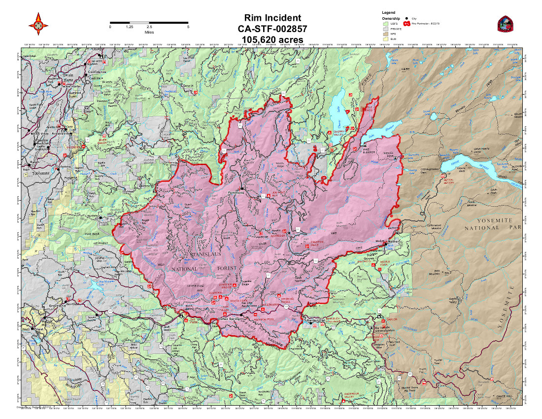
We're back from a short backpacking trip to Yosemite (we'll post a Trip Report in the future) but we thought you might be interested in seeing just exactly what the damage from the Rim Fire looks like as you drive by some of the burn area on Highway 120 through Big Oak Flat and into Yosemite.

The good news? There are huge parts of this fire that are described as having burned---and yet still have plenty of green trees in place. The fire in these areas was obviously not so hot, and burned only the understory of the forest. In fact, the larger trees seemed to do better, probably because their lower branches had long since fallen away, and there was little to catch fire at that lower level. As long as the bark and cambium layer wasn't damaged, those trees are fine.


The first photo shows an overview of the section of the fire that burned in Yosemite...with both green trees and burn damage.

And Highway 120, at forty feet wide or so, was a pretty good firebreak in a lot of areas. You can see where the fire burned the understory on one side of the highway, but the fire crews were able to keep it from crossing into the forest on the other side of the road. Nice work.

There are also some areas where the only thing that didn't burn is the building along the road---as the fire burned the entire forest right up to the edge of the buildings.


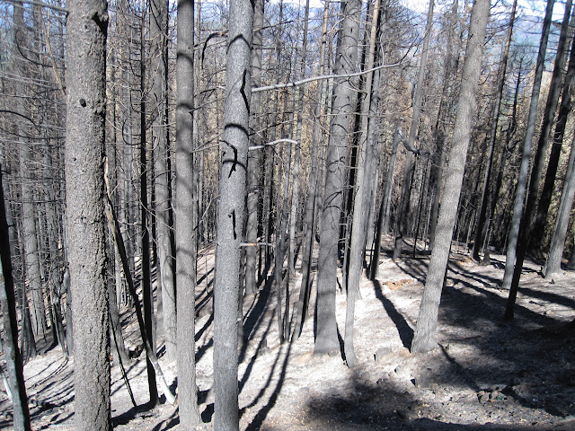
But there are also scenes of real devastation--whole sections of the forest that are now just burnt sticks. This is between the Big Oak Flat Entrance Station and Crane Flat. They are clearly trying to log some of these areas right now, so that the fire danger doesn't get even worse...and some of that lumber can be salvaged. But other areas are just burnt to a crisp. The trees are all dead, the foliage is burnt off, and the ground is black and white ashes.

It's hard to imagine these areas making a quick comeback, and we've all hiked through enough burned areas to know that ten years from now, many of these black stumps will still be the tallest things in this part of the forest.


We were particularly saddened by this fire damage up the side of one of Yosemite's distinctive granite domes. Those trees, which took centuries to grow that big, will never come back in our lifetime. The first clearly shot right up the side of the dome, and burned everything until it ran out of fuel.

And as a final note, the view from the Rim of the World is pretty desolate. Here there was as much brush as trees, and it all went up in smoke. Most of what you can see from this overlook is black soil--and only a few tiny spots where something green might still be living.


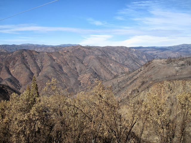
And yes, there are still a few tiny spots in the middle of this devastation where there is something green still alive.

And feeling very lonely.


Check our our website: http://www.backpackthesierra.com/
Or just read a good mystery novel set in the Sierra; https://www.amazon.com/Danger-Falling-Rocks-Paul-Wagner/dp/0984884963
avatar Re: Rim Fire Updates <maps-photos-articles-commentary>
October 01, 2013 12:06PM
It's all been burned before. It will come back.

w/r to the Dome (Davey Llama Dome) ... that is just Manz that burned...

Just like Henry Coe... give a 5 years. It'll all be back.

Mother Nature works that way. Man has his hands in too many things. Trying to control everything.

And the NF ... Tree Farm

Drove thru twice now... once with the wife... from 120... it's not that bad.


Chick-on is looking at you!
avatar Re: Rim Fire Updates <maps-photos-articles-commentary>
October 01, 2013 12:57PM
Part of the problem is that when some people see a tree all the see are dollar signs. They see those burnt trees and think of how much money was lost. Those fires did not destroy the forest, they destroyed plans for the lumber.

Think of those burnt, standing, trunks as time release fertilizer. As they fall over the decades they will release their nutrients back into the forest. That's what forest do; they burn, they regrow. The forest has not been destroyed, it's just doing what it is supposed to do.
avatar Re: Rim Fire Updates <maps-photos-articles-commentary>
October 07, 2013 09:42AM
Revival already under way in Rim Fire burn zone


Groveland, Tuolumne County -- From the interior of the Rim Fire, charred, dead trees stretch for miles down the canyon and across to a bare mountain face incinerated into a moonscape.

Yet across the blackened earth, gray ash and tanged scent of burned wood, a bracken fern sprouted last week and stretched skyward, as life emerged anew.

Amid downed trees and charred ground, a lone deer found a small, fresh patch of grass that pushed up from the ash. In areas where oaks were charred by ground fires but yet survived, chipmunks and squirrels searched and found acorns for their winter stashes.

The land's rebirth has started, campgrounds and recreation facilities have been largely protected, and the landscape has begun to heal after the Rim Fire reached 92 percent containment.

More here


The body betrays and the weather conspires, hopefully, not on the same day.
Sorry, only registered users may post in this forum.

Click here to login