- The Big Oak Flat Road (the continuation of Highway 120 inside Yosemite) and Highway 120 west of Yosemite are closed between the Highway 49 south junction (outside the park) to Crane Flat Campground (inside the park). If you are trying to get to Yosemite from the west, use Highway 140 from Merced. You may also enter Yosemite via Highway 41 from the south and 120 from the east (Tioga Pass).
- Hetch Hetchy Road and Evergreen Road are closed.
- White Wolf is closed, including the lodge, campground, road, and trails originating from White Wolf. This area is closed due to smoky conditions.
- Hodgdon Meadow Campground and Hetch Hetchy Backpackers' Campground are closed.
- Tamarack Flat Campground and Yosemite Creek Campground are slowly being vacated due to slow ingress/egress.
- Merced and Tuolumne Groves of Giant Sequoias are closed so firefighters can work on preventive fire suppression efforts. The groves are not currently in imminent danger.
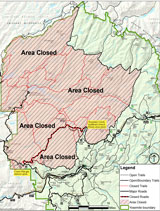
- Wilderness trail closures: The area west of the Harden Lake/Pate Valley trail, north from Pate Valley to the junction with the Pacific Crest Trail (PCT) and continuing north along the PCT to Bond Pass is closed. The park’s boundary serves as the closure’s northern and western edge south to the Merced Grove. The closure continues east along (but not including) the Tioga Road (Hwy 120 through the park) to the White Wolf Road. The Tioga Road and the trails serving as the eastern boundary of the closed area (including the PCT) remain open. View a map showing the closure
All posts are those of the individual authors and the owner
of this site does not endorse them. Content should be considered opinion
and not fact until verified independently.
August 25, 2013 06:50PM | Admin Registered: 15 years ago Posts: 17,050 |
August 25, 2013 07:19PM | Moderator Registered: 14 years ago Posts: 1,634 |
|
Re: Yosemite Rim Fire Closures August 25, 2013 07:46PM | Registered: 15 years ago Posts: 543 |
There is a live webcam from the Crane Flat Helibase:
http://ssgic.cr.usgs.gov/cgi-bin/camHist11.pl?camera=1_mobile_ynp_1&lastFrame=true
http://ssgic.cr.usgs.gov/cgi-bin/camHist11.pl?camera=1_mobile_ynp_1&lastFrame=true
August 25, 2013 09:32PM | Moderator Registered: 14 years ago Posts: 1,634 |
August 26, 2013 06:07PM | Admin Registered: 15 years ago Posts: 17,050 |
Information below updated on August 26, 2013 at 3:40 pm.
Most of Yosemite National Park is not affected by the fire and is relatively smoke-free. The northern part of the park, including some areas along the Tioga Road, has some smoke. Conditions may change if winds shift. However:
Closure map
Most of Yosemite National Park is not affected by the fire and is relatively smoke-free. The northern part of the park, including some areas along the Tioga Road, has some smoke. Conditions may change if winds shift. However:
- The Big Oak Flat Road (the continuation of Highway 120 inside Yosemite) and Highway 120 west of Yosemite are closed between J132 near Buck Meadows (outside the park) to Crane Flat Campground (inside the park). If you are trying to get to Yosemite from the west, use Highway 140 from Merced. You may also enter Yosemite via Highway 41 from the south and 120 from the east (Tioga Pass).
- Hetch Hetchy Road and Evergreen Road are closed.
- White Wolf is closed, including the lodge, campground, road, and trails originating from White Wolf. This area is closed due to smoky conditions.
- Crane Flat, Hodgdon Meadow Campground and Hetch Hetchy Backpackers' Campground are closed.
- Merced and Tuolumne Groves of Giant Sequoias are closed so firefighters can work on preventive fire suppression efforts. The groves are not currently in imminent danger.
- Wilderness trail closures: The area west of the May Lake Road and May Lake Trail continuing to the junction with the Pacific Crest Trail (PCT) at Glen Aulin and then north along the PCT to Bond Pass is closed. The park's boundary serves as the closure's northern and western edge extending south to Crane Flat Campground. The closure boundary continues east along the Tioga Road (Highway 120 through the park) to the May Lake Road. The Tioga Road and the trails serving as the eastern boundary of the closed area (including the PCT) remain open.
- May Lake High Sierra Camp, Glen Aulin High Sierra Camp, and Porcupine Flat Campground are open.
- Fire restrictions: No smoking and no building, maintaining, or using a fire, campfire or cooking fire (including charcoal fires) within the Yosemite Wilderness and potential wilderness additions. Portable stoves using gas or pressuring liquid fuel are allowed. Alcohol and Sierra stoves are not allowed. Campfires may still be used in designated campsites at designated campgrounds in non-wilderness areas within the park.
- All other roads and areas are open. Yosemite Valley, Glacier Point, Wawona, Mariposa Grove, and Tuolumne Meadows areas are all open. Campgrounds in Wawona, Bridalveil Creek, Yosemite Valley, Porcupine Flat, and Tuolumne Meadows are open.
Closure map
|
Re: Yosemite Rim Fire Closures August 27, 2013 11:07AM | Registered: 10 years ago Posts: 144 |

August 27, 2013 11:27AM | Admin Registered: 15 years ago Posts: 17,050 |
Information below updated on August 27, 2013 at 10 am.
Most of Yosemite National Park is not affected by the fire and is relatively smoke-free. The northern part of the park, including some areas along the Tioga Road, has some smoke. Conditions may change if winds shift. However:
Most of Yosemite National Park is not affected by the fire and is relatively smoke-free. The northern part of the park, including some areas along the Tioga Road, has some smoke. Conditions may change if winds shift. However:
- The Big Oak Flat Road (the continuation of Highway 120 inside Yosemite) and Highway 120 west of Yosemite are closed between J132 near Buck Meadows (outside the park) to Crane Flat Campground (inside the park). If you are trying to get to Yosemite from the west, use Highway 140 from Merced. You may also enter Yosemite via Highway 41 from the south and 120 from the east (Tioga Pass).
- Hetch Hetchy Road and Evergreen Road are closed.
- White Wolf is closed, including the lodge, campground, road, and trails originating from White Wolf. This area is closed due to smoky conditions.
- Crane Flat, Hodgdon Meadow, Tamarack Flat, Yosemite Creek, and White Wolf Campgrounds and Hetch Hetchy Backpackers' Campground are closed.
- Merced and Tuolumne Groves of Giant Sequoias are closed so firefighters can work on preventive fire suppression efforts. The groves are not currently in imminent danger.
- Wilderness trail closures: The area west of the May Lake Road and May Lake Trail continuing to the junction with the Pacific Crest Trail (PCT) at Glen Aulin and then north along the PCT to Bond Pass is closed. The park's boundary serves as the closure's northern and western edge extending south to Crane Flat Campground. The closure boundary continues east along the Tioga Road (Highway 120 through the park) to the May Lake Road. The Tioga Road and the trails serving as the eastern boundary of the closed area (including the PCT) remain open. May Lake High Sierra Camp, Glen Aulin High Sierra Camp, and Porcupine Flat Campground are open. View a map showing the closure [1.2 MB PDF].
- Fire restrictions: No smoking and no building, maintaining, or using a fire, campfire or cooking fire (including charcoal fires) within the Yosemite Wilderness and potential wilderness additions. Portable stoves using gas or pressuring liquid fuel are allowed. Alcohol and Sierra stoves are not allowed. Campfires may still be used in designated campsites at designated campgrounds in non-wilderness areas within the park.
- All other roads and areas are open. Yosemite Valley, Glacier Point, Wawona, Mariposa Grove, and Tuolumne Meadows areas are all open. Campgrounds in Wawona, Bridalveil Creek, Yosemite Valley, Porcupine Flat, and Tuolumne Meadows are open.
|
Re: Yosemite Rim Fire Closures 8/27 at 10am August 27, 2013 12:41PM | Registered: 13 years ago Posts: 617 |
Quote
eeek
- The Big Oak Flat Road (the continuation of Highway 120 inside Yosemite) and Highway 120 west of Yosemite are closed between J132 near Buck Meadows (outside the park) to Crane Flat Campground (inside the park). If you are trying to get to Yosemite from the west, use Highway 140 from Merced. You may also enter Yosemite via Highway 41 from the south and 120 from the east (Tioga Pass).
- Wilderness trail closures: The area west of the May Lake Road and May Lake Trail continuing to the junction with the Pacific Crest Trail (PCT) at Glen Aulin and then north along the PCT to Bond Pass is closed. The park's boundary serves as the closure's northern and western edge extending south to Crane Flat Campground. The closure boundary continues east along the Tioga Road (Highway 120 through the park) to the May Lake Road. The Tioga Road and the trails serving as the eastern boundary of the closed area (including the PCT) remain open.
Just so I'm sure I'm reading this correctly, does this mean that Tioga Road is completely open or only open between May Lake Road and out through Tioga Pass? I read the second bullet as only applying to the trails north of Tioga Rd in that stretch, not to the road itself. Is that correct? In other words, is it possible to get from the Valley to Tuolumne Meadows? (and by "possible" I mean going through Crane Flat, not heading out the south entrance, over to 395 and back in that way!)
August 27, 2013 12:44PM | Admin Registered: 15 years ago Posts: 17,050 |
August 27, 2013 03:16PM | Registered: 13 years ago Posts: 424 |
August 27, 2013 03:40PM | Admin Registered: 15 years ago Posts: 17,050 |
Information below updated on August 27, 2013 at 3:15 pm.
Most of Yosemite National Park is not affected by the fire and is relatively smoke-free. The northern part of the park, including some areas along the Tioga Road, has some smoke. Conditions may change if winds shift. However:
Most of Yosemite National Park is not affected by the fire and is relatively smoke-free. The northern part of the park, including some areas along the Tioga Road, has some smoke. Conditions may change if winds shift. However:
- The Big Oak Flat Road (the continuation of Highway 120 inside Yosemite) and Highway 120 west of Yosemite are closed between J132 near Buck Meadows (outside the park) to Crane Flat (inside the park). Beginning at noon on Wednesday, August 28, the only access to Yosemite Valley is via Highway 140 from Merced or Highway 41 from Fresno.
- Beginning at noon on Wednesday, August 28, the Tioga Road (Highway 120 through the park) is closed from Crane Flat to Yosemite Creek. The only access to the Tuolumne Meadows area is via Highway 120 from near Lee Vining.
- Hetch Hetchy Road and Evergreen Road are closed.
- White Wolf is closed, including the lodge, campground, road, and trails originating from White Wolf.
- Crane Flat, Hodgdon Meadow, Tamarack Flat, Yosemite Creek, and White Wolf Campgrounds and Hetch Hetchy Backpackers' Campground are closed.
- Merced and Tuolumne Groves of Giant Sequoias are closed so firefighters can work on preventive fire suppression efforts. The groves are not currently in imminent danger.
- Wilderness trail closures: The area west of the May Lake Road and May Lake Trail continuing to the junction with the Pacific Crest Trail (PCT) at Glen Aulin and then north along the PCT to Bond Pass is closed. The park’s boundary serves as the closure’s northern and western edge extending south to the junction of the Big Oak Flat Road and Tioga Road at Crane Flat. The closure’s boundary continues east from Crane Flat paralleling the Tioga Road a half mile to its south to the Tamarack Flat Campground Road. The closure follows the Tamarack Flat Campground Road to the campground then continues on the Tamarack Creek trail then east along the North Rim trail to the Yosemite Creek Trail north to the Tioga Road. The closure then follows the Tioga Road east to the May Lake Road. The trails serving as the eastern and southern boundary of the closed area remain open. May Lake High Sierra Camp, Glen Aulin High Sierra Camp, and Porcupine Flat Campground are open. A new map will be posted soon.
August 28, 2013 03:26PM | Admin Registered: 15 years ago Posts: 17,050 |
Information below updated on August 28, 2013 at noon (most of the information on this page has been updated).
Most of Yosemite National Park is not affected by the fire and is relatively smoke-free. The northern part of the park, including some areas along the Tioga Road, has some smoke. Conditions may change if winds shift. However, the following temporary closures and restrictions are in effect
View a map of the closed area [1.3 MB PDF].
(This map only shows a portion of Yosemite National Park.)
- The Big Oak Flat Road (the continuation of Highway 120 inside Yosemite) is closed from Big Oak Flat Entrance Station to Crane Flat. The only access to Yosemite Valley is via Highway 140 from Merced or Highway 41 from Fresno (view alternate routes). All facilities and areas along the Big Oak Flat Road west of Crane Flat are closed, including Tuolumne and Merced Groves of Giant Sequoias (which are not in imminent danger), Hodgdon Meadow and Crane Flat Campgrounds, and the Big Oak Flat Information station. The Crane Flat gas station and store are open.
- The Tioga Road (Highway 120 through the park) is closed from Crane Flat to Ten Lakes Trailhead (just west of Yosemite Creek Picnic Area). The only access to the Tuolumne Meadows area is via Highway 120 from near Lee Vining (view alternate routes). All facilities and areas along the Tioga Road west of Ten Lakes Trailhead are closed, including Tamarack Flat, White Wolf, and Yosemite Creek Campgrounds, and White Wolf Lodge. Ten Lakes Trailhead parking is closed, but the Yosemite Creek Picnic Area is open.
- The Hetch Hetchy Road, including all areas and facilities along the road, is closed.
- The Old Coulterville Road is closed west and north of its junction with 1st Street (near Foresta). Old Coulterville Road in the community of Foresta is open. Residential access to Flying Spur Ranch is allowed. View a map of this closure [2.7 MB PDF].
- Wilderness trail closures: The area west of the May Lake Road and May Lake Trail continuing to the junction with the Pacific Crest Trail (PCT) at Glen Aulin and then north along the PCT to Bond Pass is closed. The park’s boundary serves as the closure’s northern and western edge extending south to the junction of the Big Oak Flat Road and Tioga Road at Crane Flat. The closure’s boundary continues east from Crane Flat paralleling the Tioga Road a half mile to its south to the Tamarack Flat Campground Road. The closure follows the Tamarack Flat Campground Road to the campground then continues on the Tamarack Creek trail to the junction with the North Rim Trail. Then east along the North Rim trail to the Yosemite Creek trail north to the Tioga Road. The closure then follows the Tioga Road east to the May Lake Road. The trails serving as the eastern and southern boundary of the closed area remain open. May Lake High Sierra Camp, Glen Aulin High Sierra Camp, and Porcupine Flat Campground are open.
- Fire restrictions:
- No smoking and no building, maintaining, attending, or using a fire, campfire, or cooking fire (including charcoal fires) within Yosemite Wilderness or at the High Sierra Camps. Portable stoves using gas or pressurized liquid fuel are allowed. Alcohol and "Sierra" stoves may not be used in wilderness under these restrictions.
- Campfires and cooking fires may still be used in designated campgrounds and picnic areas in developed portions of the park in accordance with park regulations.
- This includes the following campgrounds, when open: Upper Pines, Lower Pines, North Pines, Camp 4, Wawona, Bridalveil Creek, Hodgdon Meadow, Crane Flat, Tamarack Flat, White Wolf, Yosemite Creek, Porcupine Flat, and Tuolumne Meadows.)
- This includes the following picnic areas, when open: Lembert Dome, Tenaya Lake, Yosemite Creek, Wawona, Mariposa Grove, Glacier Point, Cascade, El Capitan, Cathedral Beach, Sentinel Beach, Swinging Bridge, Church Bowl, and Lower Yosemite Fall.
August 31, 2013 01:00PM | Admin Registered: 15 years ago Posts: 17,050 |
Information below updated on August 31, 2013 at noon.
Most of Yosemite National Park is open. Winds in the Yosemite area have shifted and caused an increased impact from the Rim Fire in the area. Heavy smoke is now visible south of the Tioga Road, including in Yosemite Valley and the Wawona area. Visitors to the area should avoid extended strenuous physical activities outdoors. Additionally, those that are sensitive to air quality impacts should avoid going outside in Yosemite.
The following temporary closures and restrictions are in effect:
Edited 1 time(s). Last edit at 08/31/2013 01:00PM by eeek.
Most of Yosemite National Park is open. Winds in the Yosemite area have shifted and caused an increased impact from the Rim Fire in the area. Heavy smoke is now visible south of the Tioga Road, including in Yosemite Valley and the Wawona area. Visitors to the area should avoid extended strenuous physical activities outdoors. Additionally, those that are sensitive to air quality impacts should avoid going outside in Yosemite.
The following temporary closures and restrictions are in effect:
- The Big Oak Flat Road (the continuation of Highway 120 inside Yosemite) is closed from Big Oak Flat Entrance Station to Crane Flat. The only access to Yosemite Valley is via Highway 140 from Merced or Highway 41 from Fresno (view alternate routes). All facilities and areas along the Big Oak Flat Road west of Crane Flat are closed, including Tuolumne and Merced Groves of Giant Sequoias (which are not in imminent danger), Hodgdon Meadow and Crane Flat Campgrounds, and the Big Oak Flat Information station. The Crane Flat gas station and store are open.
- The Tioga Road (Highway 120 through the park) is closed from Crane Flat to Ten Lakes Trailhead (just west of Yosemite Creek Picnic Area), at least through September 2, 2013. The only access to the Tuolumne Meadows area is via Highway 120 from near Lee Vining (view alternate routes). All facilities and areas along the Tioga Road west of Ten Lakes Trailhead are closed, including Tamarack Flat, White Wolf, and Yosemite Creek Campgrounds, and White Wolf Lodge. Ten Lakes Trailhead parking is closed, but the Yosemite Creek Picnic Area is open.
- The Hetch Hetchy Road, including all areas and facilities along the road, is closed.
- The Old Coulterville Road is closed west and north of its junction with 1st Street (near Foresta). Old Coulterville Road in the community of Foresta is open. Residential access to Flying Spur Ranch is allowed.
- Wilderness trail closures: The area west of the May Lake Road and May Lake Trail continuing to the junction with the Pacific Crest Trail (PCT) at Glen Aulin and then north along the PCT to Bond Pass is closed. The park’s boundary serves as the closure’s northern and western edge extending south to the junction of the Big Oak Flat Road and Tioga Road at Crane Flat. The closure’s boundary continues east from Crane Flat paralleling the Tioga Road a half mile to its south to the Tamarack Flat Campground Road. The closure follows the Tamarack Flat Campground Road to the campground then continues on the Tamarack Creek trail to the junction with the North Rim Trail. Then east along the North Rim trail to the Yosemite Creek trail north to the Tioga Road. The closure then follows the Tioga Road east to the May Lake Road. The trails serving as the eastern and southern boundary of the closed area remain open. May Lake High Sierra Camp, Glen Aulin High Sierra Camp, and Porcupine Flat Campground are open.
- Fire restrictions:
- No smoking and no building, maintaining, attending, or using a fire, campfire, or cooking fire (including charcoal fires) within Yosemite Wilderness or at the High Sierra Camps. Portable stoves using gas or pressurized liquid fuel are allowed. Alcohol and "Sierra" stoves may not be used in wilderness under these restrictions.
- Campfires and cooking fires may still be used in designated campgrounds and picnic areas in developed portions of the park in accordance with park regulations.
- This includes the following campgrounds, when open: Upper Pines, Lower Pines, North Pines, Camp 4, Wawona, Bridalveil Creek, Hodgdon Meadow, Crane Flat, Tamarack Flat, White Wolf, Yosemite Creek, Porcupine Flat, and Tuolumne Meadows.)
- This includes the following picnic areas, when open: Lembert Dome, Tenaya Lake, Yosemite Creek, Wawona, Mariposa Grove, Glacier Point, Cascade, El Capitan, Cathedral Beach, Sentinel Beach, Swinging Bridge, Church Bowl, and Lower Yosemite Fall.
Edited 1 time(s). Last edit at 08/31/2013 01:00PM by eeek.
Sorry, only registered users may post in this forum.

