...I'll skip the part about how thrilling it is to go back to the park. (you already know)
Day 1 - Long and winding road
My grandiose plan for this trip would be to do a hike that had never been done. It would be Half Dome,
Clouds Rest (the east flank), and a second summit of HD. Mother Nature would not be impressed.
I got started at 4am (Sept 3), and would soon be atop the Mist Trail. My headlamp would soon bring
this ominous warning into view....
sign
With temps in the upper 90s, much water would be needed, so I stashed 3 2 liter bottles at the 7000 ft junction, and
with 3 quarts on hand, headed up the trail. After showing my permit to a lovely young thing from Montana at the
sub dome base, I was soon joined by almost nobody on the cables....
cables
This was my third time on top of Half Dome, but others were there first. Be nice....
ducks
Back at the junction, I grabbed 2 full bottles, and headed for CR. Why go the long way, via the JMT to the eastern
approach? Photos on this site made this approach look cooler than the shorter, western flank, and remember,
this would be a hike that nobody had ever done before. But.....
At about 9000 ft, it began to lightly rain. At 9200, hail joined the party. Could lightning be far behind?
I had a choice to make: Go for the top, cursing the elements along the way, or bail and backtrack all the
way down. I waited a few minutes till the light hail stopped, and (not recommended) headed up.
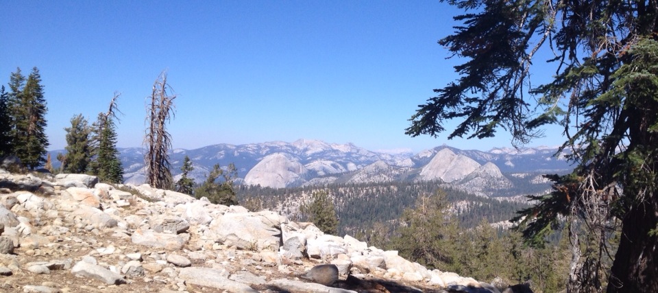
There were many times on this trip when I wanted to pull over beside the trail and bawl like a school girl, overcome
by the unspeakable magnificence of this singular place. This was one such time...
clouds rest
After taking 10 hours to reach the top of CR, I spent about 30 seconds there. With storm clouds in the area, there was
no worse place to be. And, about a minute after leaving the top, an old familiar rumble from above began. Descent is
a good thing.
I got to the junction at around 4 pm, plenty of time to complete the hike, but the rain would make the dome beyond
slick, and the heavens still shook. Mother nature had won. Mortal man had lost. I grabbed all my stash, and headed home.
The next few days would bring more defeats, and the odd victory. Like this...
pie

The Moon is Waxing Gibbous (58% of Full)
Re: Trip report: Pleasure and pain
All posts are those of the individual authors and the owner
of this site does not endorse them. Content should be considered opinion
and not fact until verified independently.
|
Trip report: Pleasure and pain September 11, 2013 07:12PM | Registered: 11 years ago Posts: 324 |
|
Re: Trip report: Pleasure and pain September 13, 2013 07:40PM | Registered: 11 years ago Posts: 324 |
Day 2 - Horse with no name
This day would call for a hike to North Dome, Indian Rock and Yosemite Point, along the north rim
of the Valley. The first landmark of the day was Mirror Lake, which had the reflective value of the sand
that represents the lake's bottom. The site did give a new view of Half Dome, which blotted out much
of the galaxy. It also gave this perspective of ND...

A couple days before, I asked an employee at Ansel Adams gallery for a book about the Yosemite
trails and the people who built them. He knew of nothing in print on that subject, but suggested
that some trails simply followed game trails. Maybe, but not the first uphill track on this day. The
Snow Creek Falls Trail was apparently patterned after an expanded slinky. The steepest active
trail to exit the Valley, this switchbacky beast must be seen to be believed, but neither is recommended.
Although partly shaded (sometimes by a cloud of gnats), the heat of the day seemed to be magnified
on this trail. I stopped every 250 vertical feet for water, but every 25 feet would've been about
right. There was supposed to be an active stream at the top, and rationing my supply, I would make
it with a gulp to spare. After struggling over the top, I heard a noise that sounded like angels singing...

After drinking like last call on a straight tequila night, I filled every container and headed north. The
trail followed the stream for a while, but as the climb toward Indian Rock began, the creek faded.
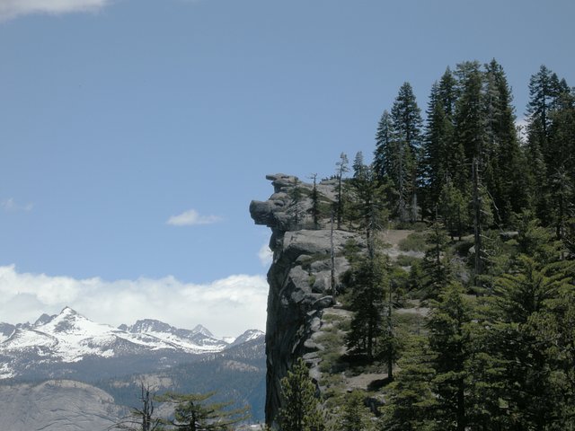
At 8500+ feet, this sight is yours to behold....

There were two people here on this day. They represented about a fourth of the hikers seen on this
entire hike. A straight shot to the south would soon bring North Dome into view, but like a desert mirage,
it seemed to be moving away, not getting closer. Was dehydration working its magic? Maybe, but
at some point, this view suggested that my feet had found their destination...

The gruesome twosome that I'd hiked the day before were a spectacular sight. I'd never looked upon
them, or anything else, from the north rim; one reason that this hike was on the list. Two more landmarks were
yet to be reached. So, I set sail on the north rim trail and another water stop, with a backpack that
kept getting too light, too soon.
The first drainage was supposed to be dry, and was. The second was Lehamite Creek. A pre-hike
check with the Wilderness Office revealed that this would have water, and the info was correct. I
wouldn't have cared if Roseanne and Oprah were skinny dipping upstream; this would be the final
water for the day, and down the hatch it went.
This is Yosemite Point....

I was really punchy at this time, so the idea of getting too close to the pipe railing that keeps the
hiker from taking a 3200 foot header was less than appealing. I also failed to even think about
snapping a shot of nearby Lost Arrow Spire. Oh well, a couple reasons to go back.
As this shot shows....

...there would be no swimming atop Yosemite Falls. In fact, the polished rock, height of the bridge
and lack of running water made it look like somebody had robbed the cookie jar. But, when looking
at the 'V' notch that countless years of water flow has eroded away, it was obvious that the hydraulic
hacksaw would not be silent for long...

By the time I made the Valley floor, the sun had dipped below the horizon. I trudged into the Village
Store, glad that the two biggest hikes of the trip were done. Tomorrow would be a fun day.
This day would call for a hike to North Dome, Indian Rock and Yosemite Point, along the north rim
of the Valley. The first landmark of the day was Mirror Lake, which had the reflective value of the sand
that represents the lake's bottom. The site did give a new view of Half Dome, which blotted out much
of the galaxy. It also gave this perspective of ND...
A couple days before, I asked an employee at Ansel Adams gallery for a book about the Yosemite
trails and the people who built them. He knew of nothing in print on that subject, but suggested
that some trails simply followed game trails. Maybe, but not the first uphill track on this day. The
Snow Creek Falls Trail was apparently patterned after an expanded slinky. The steepest active
trail to exit the Valley, this switchbacky beast must be seen to be believed, but neither is recommended.
Although partly shaded (sometimes by a cloud of gnats), the heat of the day seemed to be magnified
on this trail. I stopped every 250 vertical feet for water, but every 25 feet would've been about
right. There was supposed to be an active stream at the top, and rationing my supply, I would make
it with a gulp to spare. After struggling over the top, I heard a noise that sounded like angels singing...
After drinking like last call on a straight tequila night, I filled every container and headed north. The
trail followed the stream for a while, but as the climb toward Indian Rock began, the creek faded.
At 8500+ feet, this sight is yours to behold....
There were two people here on this day. They represented about a fourth of the hikers seen on this
entire hike. A straight shot to the south would soon bring North Dome into view, but like a desert mirage,
it seemed to be moving away, not getting closer. Was dehydration working its magic? Maybe, but
at some point, this view suggested that my feet had found their destination...
The gruesome twosome that I'd hiked the day before were a spectacular sight. I'd never looked upon
them, or anything else, from the north rim; one reason that this hike was on the list. Two more landmarks were
yet to be reached. So, I set sail on the north rim trail and another water stop, with a backpack that
kept getting too light, too soon.
The first drainage was supposed to be dry, and was. The second was Lehamite Creek. A pre-hike
check with the Wilderness Office revealed that this would have water, and the info was correct. I
wouldn't have cared if Roseanne and Oprah were skinny dipping upstream; this would be the final
water for the day, and down the hatch it went.
This is Yosemite Point....
I was really punchy at this time, so the idea of getting too close to the pipe railing that keeps the
hiker from taking a 3200 foot header was less than appealing. I also failed to even think about
snapping a shot of nearby Lost Arrow Spire. Oh well, a couple reasons to go back.
As this shot shows....
...there would be no swimming atop Yosemite Falls. In fact, the polished rock, height of the bridge
and lack of running water made it look like somebody had robbed the cookie jar. But, when looking
at the 'V' notch that countless years of water flow has eroded away, it was obvious that the hydraulic
hacksaw would not be silent for long...
By the time I made the Valley floor, the sun had dipped below the horizon. I trudged into the Village
Store, glad that the two biggest hikes of the trip were done. Tomorrow would be a fun day.
September 14, 2013 12:59AM | Registered: 15 years ago Posts: 4,173 |
Just want to thank you for posting your detail trip reports. I've enjoyed reading them and emphasize with your trials and tribulations of your hikes. At times, one just has to be philosophical about the ups and downs one experiences on a wilderness adventure. I also enjoyed viewing all the photos that you posted.
Looking forward to your next installment.
.
Looking forward to your next installment.
.
|
Re: Trip report: Pleasure and pain September 14, 2013 06:37AM | Registered: 13 years ago Posts: 617 |
 looking forward to the next installment.
|
Re: Trip report: Pleasure and pain September 14, 2013 03:09PM | Registered: 12 years ago Posts: 953 |
|
Re: Trip report: Pleasure and pain September 15, 2013 03:05PM | Registered: 11 years ago Posts: 324 |
Day 3: Like a rolling stone
(For this one, I must type in hushed tones)
After a couple big hikes, this day would be going to a place of mystery and intrigue. Thanks mainly to this
forum, I have learned of a place that exists, but cannot be reached. It once hosted the footprints of many
a hiking boot, but is now considered taboo. Mother Nature graced this destination with a view of 4 different
waterfalls, then blocked access to that view with a cascade of granite projectiles. You undoubtedly know
the name of this spot, but do keep it on the QT; this is our little secret.
The day started with a trip to the Curry dining pavilion. The breakfast buffet of a year ago is gone, but the
ala carte offerings get a marginal thumbs up. I stocked the pack with the usual provisions and headed
for the Happy Isles trailhead. (There would be no water source on the route, so sightings of rotund
celebs having girl time would have to wait for another day.)
Vital to any hike is knowing where to start, and with this one exempt from current maps, that could be
a problem. Not so. Look for a "Rock Pile" sign on the trail to Vernal Fall. It might as well be a big 'X'
on the ground. Some very big rocks will grab your attention from the paved trail. Head for them, and
once above, continue mainly straight upward toward a pair of good sized trees. The trail veers off
to the right at this point. Look closely; it exists.
The steep, switchbacking route shows evidence of the original trail...

...and, on this day, was marked by the occasional trail duck. Keep in mind that this trail hasn't seen
any maintenance in years, so even the steps of yore are littered with dry leaves, gravel and other
indigenous debris.
This is more of a scramble than a hike, so be prepared to use both hands and feet. Going up, I was
concerned about the descent, thinking that it would be more dangerous. (Except for a couple spots,
it wasn't) Also, this is no place for tennis shoes. Break out the hard soled hiking boots; you'll use their
edges to dig into the slope like skis on steep, packed snow.
Facing uphill, the route generally angles to the right, and when the noise of the river and the hikers
on the trail below have gone silent, you're getting close. The trail will begin to level off, and rounding
a slight bend will bring a sight akin to buried treasure....

Illilouette Fall is yours, front and center, with iconic Yosemite Falls to the right. To the left....

...so yes, the hype is real. It becomes immediately apparent why a trail was built to this spot. Our
little secret is one of the cool places in Yosemite; a true "bawl like a school girl" moment. And,
we can thank the ancient craftsman who hauled
his tools to this place and fashioned the pipe railing. Without his efforts, a fall from this vantage
point would make it really tough to get aboard the shuttle bus....

All told, this day was a pure joy. The hike/scramble could easily be done in a morning and had
just enough danger to keep the senses on edge the whole time. Since nobody (but us) knows
of this place, that's who I saw on the entire route. The terminus of the trail is a good picnic spot
and almost the entire distance was shaded. This "hike" became an instant favorite, and one that
I'll do when/if I get back to the park. (I almost did it again that afternoon)
So, there you have it. A really cool place within a really cool place. But, we have to keep this to
ourselves. So, if asked, remember....this place doesn't exist, you never heard of it, nobody
saw a thing, and....

The next day would bring about the most memorable moment I've ever had in Yosemite.
(For this one, I must type in hushed tones)
After a couple big hikes, this day would be going to a place of mystery and intrigue. Thanks mainly to this
forum, I have learned of a place that exists, but cannot be reached. It once hosted the footprints of many
a hiking boot, but is now considered taboo. Mother Nature graced this destination with a view of 4 different
waterfalls, then blocked access to that view with a cascade of granite projectiles. You undoubtedly know
the name of this spot, but do keep it on the QT; this is our little secret.
The day started with a trip to the Curry dining pavilion. The breakfast buffet of a year ago is gone, but the
ala carte offerings get a marginal thumbs up. I stocked the pack with the usual provisions and headed
for the Happy Isles trailhead. (There would be no water source on the route, so sightings of rotund
celebs having girl time would have to wait for another day.)
Vital to any hike is knowing where to start, and with this one exempt from current maps, that could be
a problem. Not so. Look for a "Rock Pile" sign on the trail to Vernal Fall. It might as well be a big 'X'
on the ground. Some very big rocks will grab your attention from the paved trail. Head for them, and
once above, continue mainly straight upward toward a pair of good sized trees. The trail veers off
to the right at this point. Look closely; it exists.
The steep, switchbacking route shows evidence of the original trail...
...and, on this day, was marked by the occasional trail duck. Keep in mind that this trail hasn't seen
any maintenance in years, so even the steps of yore are littered with dry leaves, gravel and other
indigenous debris.
This is more of a scramble than a hike, so be prepared to use both hands and feet. Going up, I was
concerned about the descent, thinking that it would be more dangerous. (Except for a couple spots,
it wasn't) Also, this is no place for tennis shoes. Break out the hard soled hiking boots; you'll use their
edges to dig into the slope like skis on steep, packed snow.
Facing uphill, the route generally angles to the right, and when the noise of the river and the hikers
on the trail below have gone silent, you're getting close. The trail will begin to level off, and rounding
a slight bend will bring a sight akin to buried treasure....
Illilouette Fall is yours, front and center, with iconic Yosemite Falls to the right. To the left....
...so yes, the hype is real. It becomes immediately apparent why a trail was built to this spot. Our
little secret is one of the cool places in Yosemite; a true "bawl like a school girl" moment. And,
we can thank the ancient craftsman who hauled
his tools to this place and fashioned the pipe railing. Without his efforts, a fall from this vantage
point would make it really tough to get aboard the shuttle bus....
All told, this day was a pure joy. The hike/scramble could easily be done in a morning and had
just enough danger to keep the senses on edge the whole time. Since nobody (but us) knows
of this place, that's who I saw on the entire route. The terminus of the trail is a good picnic spot
and almost the entire distance was shaded. This "hike" became an instant favorite, and one that
I'll do when/if I get back to the park. (I almost did it again that afternoon)
So, there you have it. A really cool place within a really cool place. But, we have to keep this to
ourselves. So, if asked, remember....this place doesn't exist, you never heard of it, nobody
saw a thing, and....
The next day would bring about the most memorable moment I've ever had in Yosemite.
|
Re: Trip report: Pleasure and pain September 15, 2013 05:16PM | Registered: 12 years ago Posts: 1,976 |
|
Re: Trip report: Pleasure and pain September 15, 2013 05:49PM | Registered: 11 years ago Posts: 324 |
|
Re: Trip report: Pleasure and pain September 15, 2013 07:12PM | Registered: 10 years ago Posts: 115 |
|
Re: Trip report: Pleasure and pain September 15, 2013 07:28PM | Registered: 12 years ago Posts: 1,976 |
|
Re: Trip report: Pleasure and pain September 15, 2013 09:27PM | Registered: 12 years ago Posts: 12 |
September 16, 2013 04:54PM | Moderator Registered: 14 years ago Posts: 7,421 |
|
Re: Trip report: Pleasure and pain September 17, 2013 10:23AM | Registered: 11 years ago Posts: 324 |
|
Re: Trip report: Pleasure and pain September 16, 2013 05:56PM | Registered: 11 years ago Posts: 324 |
Day 4: Soulshine
A year ago, I did the 4 Mile Trail/Glacier Pt./Panorama Trail loop, and it proved to be one of the great
days ever in Yosemite. This year, after scrapping a hike to El Cap due to lack of water (I won't be hauling
2 gallons up THAT trail), I decided to do this hike again. For some reason, I would be going down the 4;
don't know why that decision was made.
Going up the JMT, the first notable landmark was this, weak flowing but spectacular Nevada Fall...

From there, the trail goes up and eventually down into Illiluette gorge. I spent/wasted a few minutes
trying to fine Panorama Point; don't think I ever did. After crossing the foot bridge, I followed the noise
of rushing water off the trail, for a vantage point that gave this view...

Illiluette Fall can be tough to find, but us guys have trouble finding all kinds of things.
The trail to Glacier Point was smoking hot, but anybody who has been to that place knows that any effort
is worth it. The place is like a big IMAX theater, with wall to wall and floor to ceiling views have GOT to
be the best in Yosemite. It is impossible to spend too much time there...

Throughout this trip, I had asked a few park employees about the prospects of reaching this spot via
a trail that aLEDGEdly goes from the Valley to this spot. They were all working at the floor level, and
all had the same, well rehearsed line about why that trail should be avoided. Thinking that someone
who works up here might have a more encouraging outlook, I entered the Glacier Pt. store.
There, I posed the same question to the cashier, who described herself as a lesbian. Instead of
lifting my spirits, she gave chapter and verse about the evils of the place. "If anyone tells me they
came up the (aLEDGEd) trail, I'll ream them a new one", was among here ravings. With each
blast of venom, I sunk lower and lower, till I exited the store, feeling an inch high.
Shortly after beginning the decent on the 4 Mile Trail, I spotted the obvious top section of this route,
which I'd daydreamed about doing on this trip. Littered with fallen logs and undergrowth, I had envisioned
triumphantly stomping up this gulch, and realizing another boyhood dream. Now, I felt like that guy
we all know - the guy who never did anything wrong, yet never had any real fun. In short, a coward.
Then, it happened.
At about the 5200 foot level, I rounded a slight bend, and came face to face with my ultimate Yosemite moment...

When first spotted, this army of one was about 100 feet away and headed for me, right on the trail. 'The book' says
to scare it away, but there was a pair of hikers on the trail below, and I didn't want to risk sending my problem to
them. Without an aggressive bone in its body, the beast simply ambled to the side of the trail and disappeared into
the brush. After a few words with the uphill hikers, I continued downward, having seen my first bear in
Yosemite. But, things were just getting started.
The bear went into the trees, turned downhill, and back onto the trail. I saw it again a minute later. This time, it was
going downhill.

When it moved, I moved. When it stopped, so did I. I shot many minutes of video. Just me and the bear.
Gradually, other downhill hikers closed in. First, a couple. Then, a group of 4. Before it ended, there were
about 15 of us, all following the Grand Marshall of our own parade. I wondered if he would go clear
to the trailhead....

I wish I knew how many times that bear got his photo taken that day! Everybody in our group told a bear
story, if they had one, and we moved as one behind our 4 legged leader. Nobody bitched. Nobody
threw a rock or stick. Nobody wanted it to end.
Finally, at the turn of a switchback, bear #2 (reddish/purple eartag), moved off trail again, and he was gone.
Thinking that he might still be in the area, I spent the next several minutes scanning the bushes as I
continued downhill. He never came back. Fare well, and good bye.
In the Curry dining pavilion, there's an enormous stuffed/toy bear at the edge of the dining room. As I
celebrated the events of the day...

...the cowardly feeling from earlier was replaced by the elation of finally getting to see a local. As I
ate, I only imagined that the beast in the dining room was looking my way, and I certainly did NOT
just see it blink. Of course, maybe luck was still with me; maybe this one didn't like whipped cream.
A year ago, I did the 4 Mile Trail/Glacier Pt./Panorama Trail loop, and it proved to be one of the great
days ever in Yosemite. This year, after scrapping a hike to El Cap due to lack of water (I won't be hauling
2 gallons up THAT trail), I decided to do this hike again. For some reason, I would be going down the 4;
don't know why that decision was made.
Going up the JMT, the first notable landmark was this, weak flowing but spectacular Nevada Fall...
From there, the trail goes up and eventually down into Illiluette gorge. I spent/wasted a few minutes
trying to fine Panorama Point; don't think I ever did. After crossing the foot bridge, I followed the noise
of rushing water off the trail, for a vantage point that gave this view...
Illiluette Fall can be tough to find, but us guys have trouble finding all kinds of things.
The trail to Glacier Point was smoking hot, but anybody who has been to that place knows that any effort
is worth it. The place is like a big IMAX theater, with wall to wall and floor to ceiling views have GOT to
be the best in Yosemite. It is impossible to spend too much time there...
Throughout this trip, I had asked a few park employees about the prospects of reaching this spot via
a trail that aLEDGEdly goes from the Valley to this spot. They were all working at the floor level, and
all had the same, well rehearsed line about why that trail should be avoided. Thinking that someone
who works up here might have a more encouraging outlook, I entered the Glacier Pt. store.
There, I posed the same question to the cashier, who described herself as a lesbian. Instead of
lifting my spirits, she gave chapter and verse about the evils of the place. "If anyone tells me they
came up the (aLEDGEd) trail, I'll ream them a new one", was among here ravings. With each
blast of venom, I sunk lower and lower, till I exited the store, feeling an inch high.
Shortly after beginning the decent on the 4 Mile Trail, I spotted the obvious top section of this route,
which I'd daydreamed about doing on this trip. Littered with fallen logs and undergrowth, I had envisioned
triumphantly stomping up this gulch, and realizing another boyhood dream. Now, I felt like that guy
we all know - the guy who never did anything wrong, yet never had any real fun. In short, a coward.
Then, it happened.
At about the 5200 foot level, I rounded a slight bend, and came face to face with my ultimate Yosemite moment...
When first spotted, this army of one was about 100 feet away and headed for me, right on the trail. 'The book' says
to scare it away, but there was a pair of hikers on the trail below, and I didn't want to risk sending my problem to
them. Without an aggressive bone in its body, the beast simply ambled to the side of the trail and disappeared into
the brush. After a few words with the uphill hikers, I continued downward, having seen my first bear in
Yosemite. But, things were just getting started.
The bear went into the trees, turned downhill, and back onto the trail. I saw it again a minute later. This time, it was
going downhill.
When it moved, I moved. When it stopped, so did I. I shot many minutes of video. Just me and the bear.
Gradually, other downhill hikers closed in. First, a couple. Then, a group of 4. Before it ended, there were
about 15 of us, all following the Grand Marshall of our own parade. I wondered if he would go clear
to the trailhead....
I wish I knew how many times that bear got his photo taken that day! Everybody in our group told a bear
story, if they had one, and we moved as one behind our 4 legged leader. Nobody bitched. Nobody
threw a rock or stick. Nobody wanted it to end.
Finally, at the turn of a switchback, bear #2 (reddish/purple eartag), moved off trail again, and he was gone.
Thinking that he might still be in the area, I spent the next several minutes scanning the bushes as I
continued downhill. He never came back. Fare well, and good bye.
In the Curry dining pavilion, there's an enormous stuffed/toy bear at the edge of the dining room. As I
celebrated the events of the day...
...the cowardly feeling from earlier was replaced by the elation of finally getting to see a local. As I
ate, I only imagined that the beast in the dining room was looking my way, and I certainly did NOT
just see it blink. Of course, maybe luck was still with me; maybe this one didn't like whipped cream.
|
Re: Trip report: Pleasure and pain September 16, 2013 06:31PM | Registered: 12 years ago Posts: 953 |
Awesome! Never have been around the same bear for that long a period of time!
Glad to hear he wasn't trying to beg/"borrow"/steal any food from you or other hikers!
What a treat you all must have had!
The 4 Mile Trail is a favorite of ours and we do a number of variations/iterations of it every year with friends, etc! And yah, never really get tired of Glacier Point!
What a great day!!! Thanks so much for sharing!!!
|
Re: Trip report: Pleasure and pain September 17, 2013 10:26AM | Registered: 11 years ago Posts: 324 |
|
Re: Trip report: Pleasure and pain September 16, 2013 06:46PM | Registered: 12 years ago Posts: 1,976 |

September 17, 2013 07:41AM | Moderator Registered: 14 years ago Posts: 7,421 |

September 17, 2013 08:34PM | Registered: 12 years ago Posts: 114 |
I think its definitely easier to locate pano point on the way down pano trail. Your practically staring it straight down as you turn to keep heading toward half dome. This is the link that guided me toward it
http://www.yosemitehikes.com/glacier-point-road/panorama-trail/trail-map.htm
http://www.yosemitehikes.com/glacier-point-road/panorama-trail/trail-map.htm
September 17, 2013 09:01PM | Moderator Registered: 14 years ago Posts: 7,421 |
|
Re: Trip report: Pleasure and pain September 18, 2013 05:03AM | Registered: 11 years ago Posts: 324 |
September 18, 2013 07:20AM | Registered: 12 years ago Posts: 13 |
September 18, 2013 11:52AM | Moderator Registered: 15 years ago Posts: 1,876 |
|
Re: Trip report: Pleasure and pain September 18, 2013 12:25PM | Registered: 13 years ago Posts: 617 |
In other words, you'd have to upload the photos to Picasa or Flickr or some other such photo-hosting site. Once they're uploaded, you can link to them individually using the "Image URL" link at the top of the messaging window on this board (don't use the regular "Insert URL" button...that'll give people the link to the picture but it won't cause the picture to show up in your message).
September 18, 2013 01:32PM | Moderator Registered: 14 years ago Posts: 7,421 |
Quote
nurcher
Can I post photos from an iPad? I really don't use a regular computer anymore , I copied the link but this all I got.
you had this:
http://http://lh3.googleusercontent.com/-xLJ5xe8xxNQ/UjmwrQu8-mI/AAAAAAAAC6g/JWQtCJXxRjk/s1024-no/IMAGE_358.jpg
Just lose the additonal http: thingie... and voila:
A Half a Dome and a 3 a Domes ala Starry King appears for all too c:

September 18, 2013 01:54PM | Registered: 12 years ago Posts: 13 |

|
Re: Trip report: Pleasure and pain September 18, 2013 06:51PM | Registered: 11 years ago Posts: 324 |
Day 5: Stranger in town
With the El Cap hike scrapped and the threat of a lesbian reaming sounding much too painful,
I decided to head back up the 4 mile trail and venture on to another couple great spots, Sentinel
Dome and Taft Point. This would be the last full day of hiking, (sniff) so I rode the shuttle bus
to the Camp 4 stop and boogied.
My hiking partner from the prior day was a no show, but the trail of my dreams/nightmares would
mock me once again...

This tree-choked gulch would mark the home stretch for....OK....moving on...
Glacier Point was as stunning as ever, just as it doubtlessly was back in the day of these two high stepping spitfires....

Unlike the view from Glacier Point, the hike uphill to Sentinel Dome is fairly bland. But, at almost 1000 feet higher than
GP, the scenery is as good, if not better....

And, the dome has something unique in the park. This is the home of the most famous dead tree in Yosemite.....

Yosemite will welcome nearly 4 million visitors this year. Add to that total the one visitor that
will never be welcome....

I'd seen almost no evidence of the Rim Fire throughout this trip, but the smoke would dominate the day,
and the conversation with other hikers. A notice on a bulletin board outside the GP store gave the totals
as 80% contained, with an overall cost of $93.5M (As of 9/8) And, it was apparently started by a lone
hunter with an illegal campfire. Be safe, bear #2.
The hike to Taft Point provided the same sphincter-clenching view of the Valley floor as many other
vantage points in the park, and one of the fissures still has a tenuous grip on a pair of boulders that
evidently took one step too many. Sorta like a fly caught in a spider's web...

I pulled into GP, for the final time, at around 3pm. You know, some people drive here, some hike,
and some climb. Some even hang-glide off of the cliff. But, for some daring souls, this is the place
to take the ultimate risk....

Chilling, eh?
Of course, some will stop at nothing to avoid a trip down the aisle....

The long trip home would begin in the morning, but not before facing a personal demon.
With the El Cap hike scrapped and the threat of a lesbian reaming sounding much too painful,
I decided to head back up the 4 mile trail and venture on to another couple great spots, Sentinel
Dome and Taft Point. This would be the last full day of hiking, (sniff) so I rode the shuttle bus
to the Camp 4 stop and boogied.
My hiking partner from the prior day was a no show, but the trail of my dreams/nightmares would
mock me once again...
This tree-choked gulch would mark the home stretch for....OK....moving on...
Glacier Point was as stunning as ever, just as it doubtlessly was back in the day of these two high stepping spitfires....
Unlike the view from Glacier Point, the hike uphill to Sentinel Dome is fairly bland. But, at almost 1000 feet higher than
GP, the scenery is as good, if not better....
And, the dome has something unique in the park. This is the home of the most famous dead tree in Yosemite.....
Yosemite will welcome nearly 4 million visitors this year. Add to that total the one visitor that
will never be welcome....
I'd seen almost no evidence of the Rim Fire throughout this trip, but the smoke would dominate the day,
and the conversation with other hikers. A notice on a bulletin board outside the GP store gave the totals
as 80% contained, with an overall cost of $93.5M (As of 9/8) And, it was apparently started by a lone
hunter with an illegal campfire. Be safe, bear #2.
The hike to Taft Point provided the same sphincter-clenching view of the Valley floor as many other
vantage points in the park, and one of the fissures still has a tenuous grip on a pair of boulders that
evidently took one step too many. Sorta like a fly caught in a spider's web...
I pulled into GP, for the final time, at around 3pm. You know, some people drive here, some hike,
and some climb. Some even hang-glide off of the cliff. But, for some daring souls, this is the place
to take the ultimate risk....
Chilling, eh?
Of course, some will stop at nothing to avoid a trip down the aisle....
The long trip home would begin in the morning, but not before facing a personal demon.
|
Re: Trip report: Pleasure and pain September 19, 2013 07:24PM | Registered: 11 years ago Posts: 324 |
Day 6: Sham-a-lam-a-ding dong
With my ride home leaving in 4 hours, options were limited. But, as I stared up at a familiar
green, diagonal line on the Glacier Point cliff...

...the devil/angel scene from Animal House came to mind, and the red guy won. I would go
as far and high as I could, and at a pre-determined time, I would stop and head back down.
At last, I would make tracks on the aLEDGEd trail.
In order to hike a trail, one must first find it. Since this, like the day 3 trail, doesn't exist, the trailhead
should be almost impossible to find. Again, it wasn't. First, find an aLEDGEd parking lot, then find
these metal posts....

Walk through them, and head straight forward and uphill till your progress is stopped by this...

Make a 90 degree turn to the right, and you're there....

I expected the worst from this place, the deadliest trail in Yosemite. Bats and vultures would blot
out the sky. Arrowed trail signs would be replaced by human skeletons with index fingers pointing
the way. Behind every boulder would be a honey badger. The air would be choked with the scent
of rotting entrails. Instead, the view from 340 feet up would look like this....

At around 400 feet was this odd site...

There could be a few reasons for this object to exist here:
1) A relaxing spot for an ancient frontiersman to enjoy his morning coffee and a chaw
2) Goal of jumpers from GP who seek a perfect one-point landing
3) An ornament for a hidden trap door. Have a seat, and your weight opens the path to a
subterranean underworld populated by victims of the trail above. A place where the strip
bars serve unfiltered, giardia laden water, and nasty celebs dish out lap dances, or worse.
Whatever its purpose, I hauled my clenching buttocks safely past, and on up the trail. It was
also at this level where the smoke from the Rim Fire became obvious....


The trail surface was probably a clean, tilted sheet of granite at one time. It is currently covered
with shattered shrapnel of countless rock falls. That, and the steepness of the ascent, made this
a scramble, instead of a hike. Normally, a little fatigue will lessen the effects of fear and paranoia,
but the unsteady footing and reputation of this place will keep your senses on edge. The trail is
comfortably wide in most spots, and trees/shrubs growing on the route ward off the fear of falling
onto the Curry Village tents....

That shot was 800 feet above, and also my turnaround point. A glance uphill showed more of
the same terrain that I'd ascended, so I stuck to the plan and headed down.
As you probably know, never go up something that you can't go down....

More than once, a carelessly placed foot caused one of these rocks to roll. On the Mist Trail or 4 Mile,
this would cause a slight loss of balance, and not much more. But, on this, the deadliest trail in
the park, that misstep was also accompanied by an almost audible pucker.
Safely back on the valley floor, I felt neither triumph or loss. The death toll of this mute beast
would hold steady, but so would the total of members of the "club"; those who have conquered the
trail, bottom to top. Undoubtedly, these steely-eyed missile men gather on occasion, to tell stories
of their victories, while drinking shots of grain alcohol and lighting their stogies with burning
sticks of dynamite.
I would leave the park on this day, without such a triumph. But, the lessons learned on this trail
will serve me well. And, as any old frat boy will tell you, knowLEDGE is good.
With my ride home leaving in 4 hours, options were limited. But, as I stared up at a familiar
green, diagonal line on the Glacier Point cliff...
...the devil/angel scene from Animal House came to mind, and the red guy won. I would go
as far and high as I could, and at a pre-determined time, I would stop and head back down.
At last, I would make tracks on the aLEDGEd trail.
In order to hike a trail, one must first find it. Since this, like the day 3 trail, doesn't exist, the trailhead
should be almost impossible to find. Again, it wasn't. First, find an aLEDGEd parking lot, then find
these metal posts....
Walk through them, and head straight forward and uphill till your progress is stopped by this...
Make a 90 degree turn to the right, and you're there....
I expected the worst from this place, the deadliest trail in Yosemite. Bats and vultures would blot
out the sky. Arrowed trail signs would be replaced by human skeletons with index fingers pointing
the way. Behind every boulder would be a honey badger. The air would be choked with the scent
of rotting entrails. Instead, the view from 340 feet up would look like this....
At around 400 feet was this odd site...
There could be a few reasons for this object to exist here:
1) A relaxing spot for an ancient frontiersman to enjoy his morning coffee and a chaw
2) Goal of jumpers from GP who seek a perfect one-point landing
3) An ornament for a hidden trap door. Have a seat, and your weight opens the path to a
subterranean underworld populated by victims of the trail above. A place where the strip
bars serve unfiltered, giardia laden water, and nasty celebs dish out lap dances, or worse.
Whatever its purpose, I hauled my clenching buttocks safely past, and on up the trail. It was
also at this level where the smoke from the Rim Fire became obvious....
The trail surface was probably a clean, tilted sheet of granite at one time. It is currently covered
with shattered shrapnel of countless rock falls. That, and the steepness of the ascent, made this
a scramble, instead of a hike. Normally, a little fatigue will lessen the effects of fear and paranoia,
but the unsteady footing and reputation of this place will keep your senses on edge. The trail is
comfortably wide in most spots, and trees/shrubs growing on the route ward off the fear of falling
onto the Curry Village tents....
That shot was 800 feet above, and also my turnaround point. A glance uphill showed more of
the same terrain that I'd ascended, so I stuck to the plan and headed down.
As you probably know, never go up something that you can't go down....
More than once, a carelessly placed foot caused one of these rocks to roll. On the Mist Trail or 4 Mile,
this would cause a slight loss of balance, and not much more. But, on this, the deadliest trail in
the park, that misstep was also accompanied by an almost audible pucker.
Safely back on the valley floor, I felt neither triumph or loss. The death toll of this mute beast
would hold steady, but so would the total of members of the "club"; those who have conquered the
trail, bottom to top. Undoubtedly, these steely-eyed missile men gather on occasion, to tell stories
of their victories, while drinking shots of grain alcohol and lighting their stogies with burning
sticks of dynamite.
I would leave the park on this day, without such a triumph. But, the lessons learned on this trail
will serve me well. And, as any old frat boy will tell you, knowLEDGE is good.
September 23, 2013 07:03AM | Moderator Registered: 14 years ago Posts: 7,421 |
TOGA TOGA TOGA
(or is it TiOGA TiOGA TiOGA)
I'm certain it's been pointed out before... but I'll repeat it anyways.
You can find some of the Old aLedgeD Trail right at Z bottom
by Curry where they condemed all the buildings...
Be warned though... the trail has a way of sucking you in...
once you start going up... you can't help but keep going.

Half a Dome fun
(and wear your "College" T-Shirt next time)
(or is it TiOGA TiOGA TiOGA)
I'm certain it's been pointed out before... but I'll repeat it anyways.
You can find some of the Old aLedgeD Trail right at Z bottom
by Curry where they condemed all the buildings...
Be warned though... the trail has a way of sucking you in...
once you start going up... you can't help but keep going.
Half a Dome fun
(and wear your "College" T-Shirt next time)
|
Re: Trip report: Pleasure and pain September 20, 2013 02:51PM | Registered: 13 years ago Posts: 617 |
|
Re: Trip report: Pleasure and pain September 20, 2013 03:00PM | Registered: 11 years ago Posts: 324 |
September 21, 2013 12:14AM | Admin Registered: 15 years ago Posts: 17,050 |
From the 4 Mile Trail I'd say:
http://yosemitephotos.net/main.php/v/yosemite/four-mile-trail/sh-dscn4506.jpg.html
http://yosemitephotos.net/main.php/v/yosemite/four-mile-trail/sh-dscn4506.jpg.html
|
Re: Trip report: Pleasure and pain September 25, 2013 07:14PM | Registered: 11 years ago Posts: 324 |
Two weeks after returning from Yosemite, here are the top ten observances/bits of info/suggestions that I have to offer:
1) GOOD DEAL - Ansel Adams gallery will charge your phone/camera battery for $5, and then recharge it, endlessly, until you
leave for home. This saved the day for at least one absent minded visitor.
2) GOOD EATS - Check out the coffee corner in Curry for ice cream. The chick who took my order didn't know how to
make a banana split, so I helped, by suggesting "more of that.....more of that..." You deserve this after a big hike.
3) My secret weapon on the trails is Gatorade Pre-game fuel. In pouch or chewable form, this stuff is nothing less
than hiking Viagra. Girls, make sure your man has some of this in the pack on every hike. 15 minutes later, you'll
be saying, "thanks, AnotherDave"!
4) Did chicks go commando back in aught-aught?

5) Being pelted by hail at 9000ft, burned by the sun on the north rim, or graced by a crystal clear morning at Glacier
Point, we all need to be aware that Mother Nature makes the rules here, and always will.
6) I don't know why, but the pipe railings that seem to be at every place bearing the name "point" have always seemed
to be, simply, cool. So are boundary markers, tree blazes and the simple Half Dome decal on local vehicles.
7) While trudging down the Pohono Trail, the light bulb came on. The trail got its name because financially strapped (po)
working girls (ho) are not allowed (no) here. And, I saw none.
8) I've been on top of Half Dome 3 times and Clouds Rest twice, but seeing and spending about 20 minutes with a young
bear will probably be a more lasting memory.
9) Everything about Sierra Point was a joy. An obvious "must do" for future visits.
10) At any time of day, Curry Village is so creepy, even the bears wear hockey masks. But, for prime location, cheap lodging and
ready access to anything a hiker could need, this place is tough to beat.
Till next time, Yosemite....
1) GOOD DEAL - Ansel Adams gallery will charge your phone/camera battery for $5, and then recharge it, endlessly, until you
leave for home. This saved the day for at least one absent minded visitor.
2) GOOD EATS - Check out the coffee corner in Curry for ice cream. The chick who took my order didn't know how to
make a banana split, so I helped, by suggesting "more of that.....more of that..." You deserve this after a big hike.
3) My secret weapon on the trails is Gatorade Pre-game fuel. In pouch or chewable form, this stuff is nothing less
than hiking Viagra. Girls, make sure your man has some of this in the pack on every hike. 15 minutes later, you'll
be saying, "thanks, AnotherDave"!
4) Did chicks go commando back in aught-aught?
5) Being pelted by hail at 9000ft, burned by the sun on the north rim, or graced by a crystal clear morning at Glacier
Point, we all need to be aware that Mother Nature makes the rules here, and always will.
6) I don't know why, but the pipe railings that seem to be at every place bearing the name "point" have always seemed
to be, simply, cool. So are boundary markers, tree blazes and the simple Half Dome decal on local vehicles.
7) While trudging down the Pohono Trail, the light bulb came on. The trail got its name because financially strapped (po)
working girls (ho) are not allowed (no) here. And, I saw none.
8) I've been on top of Half Dome 3 times and Clouds Rest twice, but seeing and spending about 20 minutes with a young
bear will probably be a more lasting memory.
9) Everything about Sierra Point was a joy. An obvious "must do" for future visits.
10) At any time of day, Curry Village is so creepy, even the bears wear hockey masks. But, for prime location, cheap lodging and
ready access to anything a hiker could need, this place is tough to beat.
Till next time, Yosemite....
Sorry, only registered users may post in this forum.

