Welcome! Log In Create A New Profile Recent Posts
A Yosemite bear

The Moon is Waxing Gibbous (54% of Full)


Advanced

Re: The Anderson Trail and Snow's Hotel

All posts are those of the individual authors and the owner of this site does not endorse them. Content should be considered opinion and not fact until verified independently.

The Anderson Trail and Snow's Hotel
February 27, 2014 06:20PM
Chick-on has kindly sent me a photo and a map related to the Anderson Spur. See http://yosemitenews.info/forum/read.php?3,26728 Here is a quote from that earlier thread:

Quote
wherever
Anderson Spur. Have you ever wondered why the trail out of Happy Isles crosses the river to go up the north bank, even though that side is rockier than the other side, and then climbs too high before it goes back down again to the Vernal Falls Bridge? Well, the John Muir Trail didn't go that way originally. (It was Mr. Snow's Trail then.) That original trail is now the horse trail, which so many hikers have stumbled down after taking a wrong turn at dusk. But there is nothing wrong with the route of the horse trail, especially now that horses are much less common on the trail than they used to be. Certainly not wrong enough to warrant building a new trail and a much bigger bridge than would have been needed at Illiouette Creek to improve the old trail. The answer goes back to the Mist Trail and the Anderson Trail, and a race to get an easy and safe trail both to the top of Vernal Falls and to Snows Hotel which was built on a large flat spot on the north bank, just above the Silver Apron and below Nevada Falls.

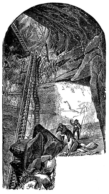
Remember, in those days most of the trails were built as toll trails, to generate profits. The Mist Trail was built about the time of Snow's Trail, which circles far above Vernal Falls before coming back down to it. But to get up Vernal Falls, the Mist Trail had a long, damp and mossy wooden ladder. At least one person fell off it and died. The attachment bolts for this ladder are still accessible on top of the outcrop. Much later, someone blasted rock so as to turn a small crack into the current ledge with railing that climbs next to the falls.


But at the time Anderson set out to build a competing trail, the Mist Trail was bad. He built a trail with much better construction technique and views than the Mist Trail, and his route would avoid the shower bath that you receive on the Mist Trail. His plan was to end his trail by blasting a ledge to the top of Vernal Falls on the north river bank, with convenient access to the falls, Emerald Pool, and the hotel. He did fantastically good work, but it took too long and the money ran out in 1882. His trail sat abandoned for a while, then in 1885 the park service took it over, and ran an extension down to the new Vernal Falls Bridge near the start of the Mist Trail. This allowed them to send horse traffic down via the old trail, much to the relief of all.

But there is still a bit of Anderson's trail above the current route. As you climb up, just before you cross a boulder field and start down to the new bridge, you will see some stonework on your left. This is the next Anderson switchback going up. You can follow it for a while, until it just ends where his dream collapsed.

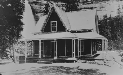
In 1870, Snow built a trail from Register Rock (where the current Mist Trail and Muir Trail split below Vernal Falls) with switchbacks up over Clark Point and back down to the river between Vernal Falls and Nevada Falls. That trail segment is still in use He then built a hotel on the north bank of the river, with a splendid view of Nevada Falls. Some of us remember the Hotel at Glacier Point, which burned down in 1969. But nobody alive today remembers Snow's Hotel, also known as La Casa Nevada, which burned in 1900. I would love to have stayed there.
http://www.nps.gov/yose/historyculture/upload/LaCasaNevada.YA.Winter2004.PDF


He opened half of the rectangular building in 1870 as shown above, the other half in 1871, and the chalet building in 1875, for a total of 22 bedrooms plus parlor, kitchen, etc., serving about 40 guests.


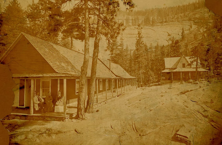
You could just sit on the back porch and watch the falls, which you can see on the left in this photo.


As you climb up from the valley today, you cross the bridge at the Silver Apron, then follow the Upper Mist Trail around to the right until you reach an open flat place at the foot of Liberty Cap where the hotel stood to your right. To your left is a grove of trees, through which a foot path passed between Liberty Cap and Mt. Broderick to Little Yosemite Valley (the current trail from there up to Nevada Falls had not yet been built).

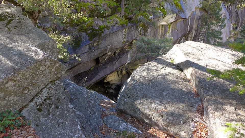
But back to Anderson and his trail. I had previously mentioned the spur of his trail which still exists, going upward from the high point in the present trail (before the present trail drops down to the bridge and comfort station below Vernal Falls). Chick-on sent me this photo from that trail:


You can see that the old stonework is still is good shape, after 130 years of neglect. There are some bushes to deal with, of course. If you look closely, you can see the poor sods toiling up the lower Mist Trail. But that is a long way down. Chick-on didn't say exactly where he took this photo, but it looks like it was from the part of the trail above Vernal Falls. I had not mentioned it, but of course Anderson had run a spur of his trail down from Snow's Hotel. It stops just as the lower spur does, at the blank granite wall where he ran out of money and blasting powder. Chick-on sent this map, showing the two abandoned spurs of the trail. The red X shows where the present trail detours around the spot where the hotel used to stand.


This upper part of the trail is still quite walkable, except for one spot next to the Emerald Pool that gets slippery in high water. At normal water levels, it is part of my preferred route up to the Diving Board. But that's another thread.

So, after Anderson failed, what became of the ladders alongside Vernal Falls? First they were up-graded, then replaced with the current blasted and pipe-railed route to the top of the falls. Here is a photo from Hutchings book of 1888 of the "improved" ladder:


Edited 1 time(s). Last edit at 02/28/2014 08:58AM by wherever.
Re: The Anderson Trail and Snow's Hotel
February 27, 2014 06:40PM
Thank you for the post. Very interesting.
Re: The Anderson Trail and Snow's Hotel
February 27, 2014 07:11PM
This was very interesting! I had no idea about any of it--
avatar Re: The Anderson Trail and Snow's Hotel
February 27, 2014 08:33PM
Quote
wherever
it is part of my preferred route up to the Diving Board. But that's another thread.

Hmmm...is that thread out there already or is it to be created...I would love to read about your preferred route to the DB....


Edited 1 time(s). Last edit at 02/27/2014 08:34PM by Bearproof.
Re: The Anderson Trail and Snow's Hotel
February 27, 2014 08:54PM
Quote
Bearproof
Quote
wherever
it is part of my preferred route up to the Diving Board. But that's another thread.

Hmmm...is that thread out there already or is it to be created...I would love to read about your preferred route to the DB....

I don't think that I have posted it. I'm not happy with my current GPS trace of it. I'll try to get around to posting it this Spring.

It's a preferred route, because I can get photographer friends up it. They love the Diving Board.

Added later: I have posted the preferred route at
http://yosemitenews.info/forum/read.php?17,72681


Edited 2 time(s). Last edit at 03/01/2014 01:01AM by wherever.
avatar Re: The Anderson Trail and Snow's Hotel
February 27, 2014 09:15PM
I have one if you want it. I went up from Emerald Pool to the slabs.
Down Shrub route... then up Broderick... and then down b/t Lib and Brod.
If you've never done Lib/Brod... that is a must do.
Up from Emerald is ... meh... just the quickest way.
Mentioned it here:
http://yosemitenews.info/forum/read.php?17,72276,72522#msg-72522


Chick-on is looking at you!
avatar Re: The Anderson Trail and Snow's Hotel
February 28, 2014 09:14AM


Honestly it's really pretty simple. I merged the up and down that just did for this map.
Pretty much just get in that gully any way you like... and you are there. The up from the gully heading
NW is all cairned. If you look closely at a topo map you can see why it goes that way.
Was looking at map and looking at the stars and decided to come down this way... turns out
it was THE way. I'm sure there are many other ways up.. I went up too high to start and ended up
dropping down a bit.
Anywho, have fun.


Chick-on is looking at you!
avatar Re: The Anderson Trail and Snow's Hotel
February 28, 2014 09:20AM
You can find AlmostDer's track of her trekkie up der here:
http://yosemitenews.info/forum/read.php?3,65836,65866#msg-65866


Chick-on is looking at you!
avatar Re: The Anderson Trail and Snow's Hotel
February 28, 2014 08:39AM
Wow! I had no idea that there used to be a hotel up there. Thanks for the informative post!
Re: The Anderson Trail and Snow's Hotel
March 01, 2014 12:59AM
I gathered some interesting information on Harold and Emily Snow from several sources over the years and one comment was that there was 11 feet of Snow below Nevada Falls on the warmest summer day; Emily was 5' tall and Harold 6' in height. Another made mention of Emily's New England wit - a young man requested more milk with his dinner and Emily stated, "Young man, it's time you were weaned!" Emily was also allegedly fond of passing a bowl of beans to her guests with the remark, "Here, have some 'strawberries!'" In the summer of 1969, the Sierra Club engaged in a massive cleanup of material left from La Casa Nevada ("the Snow House"winking smiley. I believe that Harold and Emily wintered in the Groveland area and may be buried there.
Re: The Anderson Trail and Snow's Hotel
March 01, 2014 10:16AM
Quote
wherever
Chick-on sent me this photo from that trail:


You can see that the old stonework is still is good shape, after 130 years of neglect. There are some bushes to deal with, of course. If you look closely, you can see the poor sods toiling up the lower Mist Trail. But that is a long way down. Chick-on didn't say exactly where he took this photo, but it looks like it was from the part of the trail above Vernal Falls. I had not mentioned it, but of course Anderson had run a spur of his trail down from Snow's Hotel. It stops just as the lower spur does, at the blank granite wall where he ran out of money and blasting powder.

Ha. The gps coordinates in the photo place it here:


So the trail is running right along the edge of the cliff, which is what a good tourist trail should do. It's not clear whether Anderson planned to go around the end of the cliff, or blast a ramp, or build a (temporary) ladder. In any case, his creditors got to him first.

By the way, Snow's original trail over Clark Point and down to the Silver Apron is quite visible in this photo. It remains part of the winter route to Little Yosemite Valley. X marks the location of his hotel. The present bridge over the Silver Apron on the upper Mist Trail is circled.


Edited 2 time(s). Last edit at 03/01/2014 11:10AM by wherever.
avatar Re: The Anderson Trail and Snow's Hotel
March 11, 2014 01:51PM
Here's what the trail up to where the ladder used to come to still looks like:


and where the ladder probably attached... (couldn't find any anchor bolts though... anyone ? )


Chick-on is looking at you!
avatar Re: The Anderson Trail and Snow's Hotel
March 11, 2014 01:53PM
Next time you are at the Silver Apron... take a look across... and you'll see Andersons Trail:


Chick-on is looking at you!
avatar Re: The Anderson Trail and Snow's Hotel
March 21, 2014 07:25AM
Overlaying historical basemap onto modern map... 37 is two portions of Anderson's Trail:


I'll let u contemplate other things on that map...
smiling smiley


Chick-on is looking at you!
Re: The Anderson Trail and Snow's Hotel
March 23, 2014 08:06PM
Thank you all for the excellent information in this thread. I love these historical topics.

And Chick-on, your maps are fantastic. Thanks so much for all of the work you put into them. History and maps are my two favorite topics! (And that last overlay map certainly has much to contemplate!)

I'm going to be in the Valley this weekend, and I plan on taking some time to poke around these locations. This thread helps immensely to point me in the right direction.


Edited 1 time(s). Last edit at 03/23/2014 08:07PM by ScottS.
avatar Re: The Anderson Trail and Snow's Hotel
March 23, 2014 09:22PM
Quote
chick-on
Overlaying historical basemap onto modern map... 37 is two portions of Anderson's Trail:


I'll let u contemplate other things on that map...
smiling smiley


Two things I'm contemplating looking at that overlay map (thanks for posting it!) is 1) what trail is [32]? Never seen that one before, and 2) why isn't the trail to Sierra Point shown?

In regards to Trail [32], did you see any former signs of it (like rock work or stone cuts) when you've been up that way?

(I presume Trail [38] between Curry Village and the Vernal Fall bridge is just a misalignment of the current stock trail. Or is it?)


.
Re: The Anderson Trail and Snow's Hotel
March 24, 2014 06:45AM
Quote
plawrence

Two things I'm contemplating looking at that overlay map (thanks for posting it!) is 1) what trail is [32]? Never seen that one before, and 2) why isn't the trail to Sierra Point shown?

In regards to Trail [32], did you see any former signs of it (like rock work or stone cuts) when you've been up that way?
.

It was mentioned in the first posting of this thread:
As you climb up from the valley today, you cross the bridge at the Silver Apron, then follow the Upper Mist Trail around to the right until you reach an open flat place at the foot of Liberty Cap where the hotel stood to your right. To your left is a grove of trees, through which a foot path passed between Liberty Cap and Mt. Broderick to Little Yosemite Valley (the current trail from there up to Nevada Falls had not yet been built).

I have followed that route a number of times (though always entering from the base of Liberty Cap, not straight up the gully from the hotel), but have never seen any stonework. I think that it was just rough footpath, not a stock trail. More of a scramble than a trail.
Re: The Anderson Trail and Snow's Hotel
March 24, 2014 12:34PM
Quote
plawrence
(I presume Trail [38] between Curry Village and the Vernal Fall bridge is just a misalignment of the current stock trail. Or is it?)

The overlay made by William and Mary Hood was meant to show historical aligments. You can expect it to be topologically correct, but not cartographically accurate.

It's a pity that we don't have the actual map that it overlays, but Chick-on has done a good job of stretching the overlay to fit various candidate maps.

http://yosemitenews.info/forum/read.php?3,48394,48394
http://yosemitenews.info/forum/read.php?3,65416,65433#msg-65433
avatar Re: The Anderson Trail and Snow's Hotel
March 25, 2014 06:53AM
The neat thing about the overlay map is that it shows trails that you will be really
hard pressed to find on any other map. Fitting it onto a modern map is sometimes
like fitting a square peg into a round hole. But regardless, if you really look you
can find some interesting tidbits.... if you're into that thing. (such as the trail on
the south side of The Merced to base of Nevada) (prob. not much of a trail tho)

w/r to Lib/Brod gully... [32] the route right next to Lib is excellent...
Here's current photo:

And for good fun... a Synth of the Gully itself (zoom in and you can see how nice it really is)
http://photosynth.net/view.aspx?cid=b3b8e9fa-8ff5-468e-bd6b-ac3b144a9071


Chick-on is looking at you!
avatar Re: The Anderson Trail and Snow's Hotel
March 25, 2014 07:41AM
The entire overlay map is here:
https://picasaweb.google.com/103089501068510688008/YoseMaps#5657046868831120002

You can find the key to the numbers in Greene1987v3

Old photo of Lib/Brod Gully (looking down <to> the trail) (not ON trail)


and... my synth of the same area:
http://photosynth.net/view.aspx?cid=12e006ba-2b64-4950-9e6e-64f3f41feead

Have fun


Chick-on is looking at you!
Re: The Anderson Trail and Snow's Hotel
March 26, 2014 03:03PM
Quote
chick-on
The entire overlay map is here:
https://picasaweb.google.com/103089501068510688008/YoseMaps#5657046868831120002

That was cruel. You didn't mention that they should look for map number 276 out of 441....

Quote
plawrence
...why isn't the trail to Sierra Point shown?

For the same reason that the Ledges Trail isn't shown. This map overlay was only about old historic trails (some of which were still in use, but nevertheless were historic). Sierra Point and the Ledges Trail were still in use at the time the overlay was made, but were not old enough to be historic. Of course, 50 years later the definition of historic might seem different to us....
avatar Re: The Anderson Trail and Snow's Hotel
March 25, 2014 11:18AM
Thanks for the update on the Liberty Cap Gully route. Looking at your photosynth of it, it would seem if there was ever a semblance of a trail with some rock work and such, it could have been very much obliviated over time due to the rockfall down that gully.

.
avatar Re: The Anderson Trail and Snow's Hotel
March 26, 2014 07:17AM
If Anderson made the trail... there would be some bits and pieces of it that
could be found. I have no doubt that it was simply a route... much like
Helen Lake Trail. Someday I'll go entirely up or down the gully and poke around...
but I really don't expect to find anything. You should do the same.


Chick-on is looking at you!
Re: The Anderson Trail and Snow's Hotel
March 02, 2014 04:55AM
thanks for a great post guys and the pics! some new history I knew nothing of. Really, really cool! would love to jump in a time machine and sit on a rocking chair on that deck. must have been a great place...
Re: The Anderson Trail and Snow's Hotel
August 31, 2016 05:24PM
This thread is quite old, yet I remember enjoying it when I first found it. I was researching the geology of Slide Mountain (in NE corner of Yosemite) and stumbled upon a picture of Casa Nevada (Snow's Hotel) that I hadn't seen here and thought others might also like.

See here: https://books.google.com/books?id=OCWRomvHGVAC&lpg=PA168&ots=mAFLEcjt9U&dq=what%20caused%20slide%20mountain%20yosemite&pg=PA177#v=onepage&q&f=false

It gives another perspective on the location relative to Broderick (and recent (at the time) rockfalls) .


Edited 2 time(s). Last edit at 09/15/2016 09:35AM by ags.
Re: The Anderson Trail and Snow's Hotel
September 13, 2016 07:45PM
Many thanks for the post. This might explain why there is so little trace of the old trail from Snow's Hotel to Little Yosemite Valley, before the Mist Trail was built. It ran between Liberty Cap and Mt. Broderick.
Sorry, only registered users may post in this forum.

Click here to login