
Here is our gps trace displayed on Google Earth. Be aware that reflections from the vertical cliffs do distort the tracks somewhat.

There have been a number of threads on this topic, but people still have trouble finding the abandoned Sierra Point Trail. This trail was still being somewhat maintained when I did it in 1963. In particular, the two chains to hang on to were still there. Even so, it was listed in the High Sierra Hiking Guide #1 Yosemite (3rd edition, 1974) as a little used trail with a stupendous view. In the 4th edition, 1985, this trail had been removed from the guidebook.
By 1988, twenty-five years after I did it the first time, it was rather overgrown. But the traffic on it as a "use trail" has picked up in recent years, and it is now much easier to find your way through the lower part. The route bypassing the location of the second chain (which formerly involved a thicket followed by steep dirt) has improved greatly with use. The steep dirt portion of the bypass has worn down to the underlying rocks, and is much easier now.
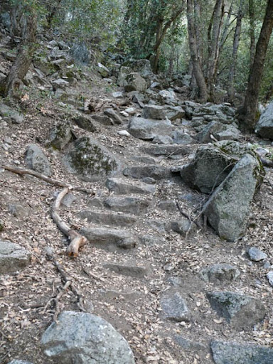
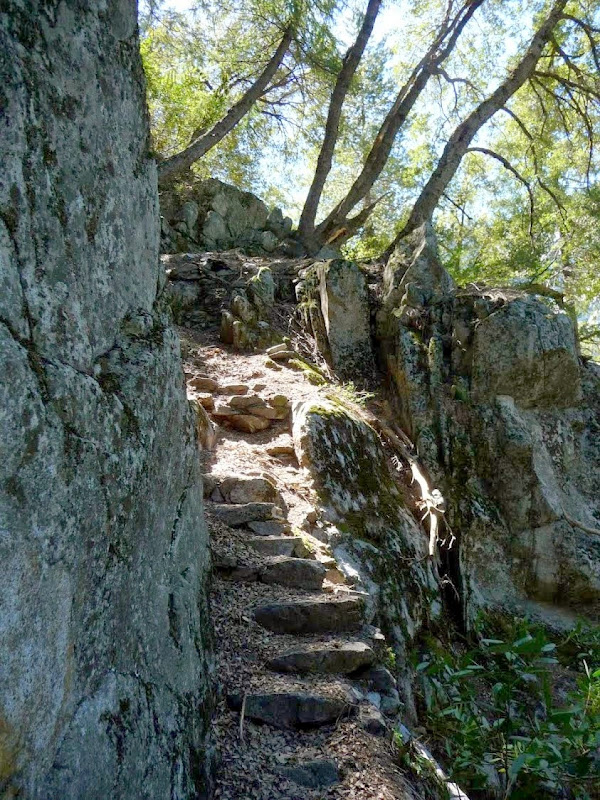
In terms of following the trail, there are three places that you need to find: 1) The starting point where it leaves the main trail to Vernal Falls, 2) the place where the trail leaves the initial boulder field to go into the woods, and 3) the place where the first chain used to be. Above that point, there are very few choices about where to go (so foot traffic has made the path quite obvious), and the old stone steps are not covered over with debris. My buddy counted 253 stone steps still in existence when we did it on Friday. Of course, some other steps are covered over with dirt and some have fallen off the cliff entirely.
The hike starts among giant boulders along the left side of the main trail, at a display poster named "Rock Piles" This is about 200 yards up the main trail from where it begins to climb towards Vernal Falls as it passes the river gauging station and a former footbridge.
Start from this sign, upwards into the boulder field. At first bear left.
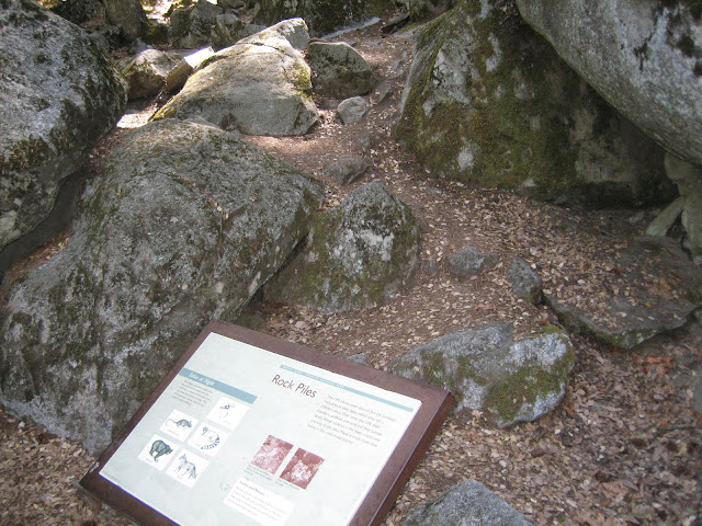
Looking back at the sign:

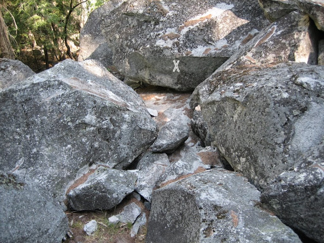
Looking up the hill from that point, proceed straight up the hill to a huge boulder (X), and and turn a corner to the right.

From higher up, looking back down at that same boulder, it looks like this.
And looking upwards you see some flat-topped boulders. Keep climbing. Pass this one on the left.

Finally, when you get to the top of this flat boulder (looking back), you are ready to leave the boulder field. The entrance to the dirt trail is in the woods right behind you.

Note added later: Chick-on sent some additional photos, which will last as long as his web site keeps them. Here is one, the entrance from the rock pile into the woods:

I don't have any good photos of the woods section of the trail. Here are two photos placed on the web by Robert House (http://www.pbase.com/roberthouse/sierratrail):

Most of this middle portion of the trail looks like the photo above. It goes steeply up the hill. The main difference between the trail and the stuff around it are the obvious signs of usage. Sometimes, though, the old steps will be found:
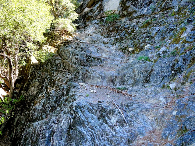
Eventually you come to the first difficult spot, where the trail starts up a broken rock face, then slants up to the left. There are plenty of hand and foot holds, but they tend to be covered with loose sand and leaf debris. This makes them slippery. I recall that there was once a chain along the rock face for your hands, which made walking there strenuous but easy. This spot is too easy to be called rock climbing, but you will definitely use handholds on the rock. It starts like this, then continues steeply up to the left.

Another photo added from chick-on, the same spot taken from a location more to the right:
Another from Chick-on, higher up the trail. Just above the sunlit spot, the stairs have simply fallen away. Be careful there. It's a long drop to the right.
After more steps and much ledge walking, you get to the site of the former second chain. The chain helped you up the next ten feet or so, after which the steps resume. , However,most people walk past this place to the right, and then bypass it on steep dirt and rocks. Coming back down, you must be alert to this detour, or the steps will take you to the top of this little scramble.

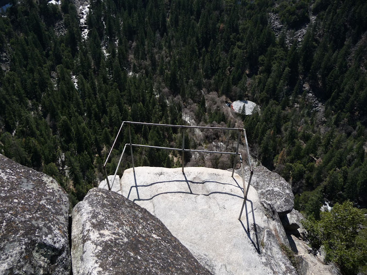
Continuing upwards on ledges and steps, you contour around the side of the mountain to the lookout spot at a huge hunk of rock. The pipe railing is just below that, reached by passing the rock on a narrow ledge to the right side of it.
From Chick-on As you contour around near the top, the trail looks like this:

There are many photos on this forum and on other web sites of the view from the pipe railing. I won't show them here, but they are fabulous. I invite you to add your own to this thread.
From Chick-on: View of the pipe railing from the big rock above it.
There are numerous places where you can fall off of this hike. That would be very bad. The second half of the hike is over cliffs everywhere. If you are not sure-footed, stay away. If you have poor footwear, stay away. If you are not used to walking on loose rocks and dirt, stay away. This is off-trail hiking, and you proceed at your own risk. The Park Service very definitely does NOT recommend this hike. In fact, they will deny the existence of this trail.
Some of the earlier threads that mention this trail:
http://yosemitenews.info/forum/read.php?3,74000
http://yosemitenews.info/forum/read.php?3,70114,70160#msg-70160
http://yosemitenews.info/forum/read.php?1,8448
http://yosemitenews.info/forum/read.php?3,52740
http://yosemitenews.info/forum/read.php?3,58380
http://yosemitenews.info/forum/read.php?1,4517
http://yosemitenews.info/forum/read.php?3,58657
http://yosemitenews.info/forum/read.php?3,51363
Edited 4 time(s). Last edit at 06/22/2014 04:07PM by wherever.
 cjh
cjh
