I recently picked up quite a few Yosemite history books which contain a good number of old photos. As I've been working my way through these, it's occurred to me that one thing I can't ever recall seeing is aerial shots of the Old Village. Obviously, these wouldn't have been taken from planes but I would have thought that there were numerous locations along the Four Mile Trail (and likely elsewhere) where such shots could have been obtained. Perhaps there just wasn't any interest in these sorts of shots but I'd have thought at least some would have been taken. I've seen hundreds of photos of various buildings around the Old Village from ground level but not from high up. Have any of you ever come across anything like this?
It's also occurred to me that the Old Village may have been too close to the south wall, or had too much tree cover to be visible from the FMT. My next trip to the Park isn't until September so feel free to correct my fuzzy memory of the view down from the FMT if need be!
All posts are those of the individual authors and the owner
of this site does not endorse them. Content should be considered opinion
and not fact until verified independently.
|
Aerial views of the Old Village June 13, 2014 07:08AM | Registered: 13 years ago Posts: 617 |
June 13, 2014 09:29AM | Registered: 14 years ago Posts: 675 |
Hmmm...a very good question and one that kept me from my appointed duties for a while this morning. All I could come across is this from the UC Berzerkely libraries...a 1944 aerial photograpgh done by the Forest Service. Probably not old enough, but it does appear to show some of the remnants. And if getting over to Kal is easier for you than getting to Yosemite you might want to check out the original for better quality.
|
Re: Aerial views of the Old Village June 13, 2014 07:37PM | Registered: 13 years ago Posts: 617 |
Quote
Bearproof
Hmmm...a very good question and one that kept me from my appointed duties for a while this morning.
Glad to be of service!
 Seriously, thanks for helping me with the digging...I wasn't able to turn up anything in my searches.
Quote
Bearproof
All I could come across is this from the UC Berzerkely libraries...a 1944 aerial photograpgh done by the Forest Service. Probably not old enough, but it does appear to show some of the remnants.
Hmm...not quite as old as I was looking for. When I have a little time, I'll see if I can put together a quick timeline of the various buildings on the south side of the Valley (starting with the earliest hotels and going at least through the hey-day of the Old Village) but just going off the top of my head, I think that much of the old village was still intact in 1944 (getting pretty long in the tooth but still largely intact). I think that they had already completed the first few buildings of what was then called Government Center (that would be the stretch over by the Post Office, Ansel Adams Gallery and Museum) but IIRC, it wasn't until the 1950's or even 60's that the last of the old village buildings was removed. Again, trusting to my far-from-infallible memory, the last to go was the old Yosemite Store. (I'm excepting the Chapel, of course, which still remains in it's Old Village location (it was moved there from a location substantially to the west some time early in the 20th century but I need to look up that date, too)).
On at least one old map I was looking at (I'll put up a link if I can find an online copy to link to), it looks like there was (perhaps not surprisingly), a more elaborate system of roads in the vicinity of Sentinel Bridge to accomodate the substantial number of buildings in the Old Village. I'm sure that the stretches that were there are far more thoroughly obliterated even than the OWR but might be fun to poke around in that area a bit.
This all, perhaps obviously, has me having to revoke my comment that any such photos would not have been taken from planes since aviation was well established by the time the Old Village was starting to wind down. In fact, planes used to land in some of the meadows which means they'd have been flying at a very good altitude for someone to grab some nice aerial shots.
Quote
Bearproof
And if getting over to Kal is easier for you than getting to Yosemite you might want to check out the original for better quality.
Nope, I'm stuck in NJ for much of each year (I like to say that I live in northern CA but happen to reside in NJ for about 48 weeks of each year but the upshot is that I typically only get out there for a few weeks each year) so won't be checking these out in person any time soon!
Edited 1 time(s). Last edit at 06/14/2014 02:06PM by DavidK42.
|
Re: Aerial views of the Old Village June 14, 2014 12:12AM | Registered: 15 years ago Posts: 141 |
A bit of information that I stumbled over in 1971 indicated that until 1943, a road ran from the north side of Sentinel Bridge northwest to about where the road leading to the NPS residential area is located. I encountered a number of old postcards that showed the road, as well as some possible out-of-print Yosemite books. I recall one paperback book that displayed old and current (1971) images of vegetation changes and that may have been one source.
June 14, 2014 10:11AM | Registered: 14 years ago Posts: 321 |
Quote
DavidK42
[
it wasn't until the 1950's or even 60's that the last of the old village buildings was removed. Again, trusting to my far-from-infallible memory, the last to go was the old Yosemite Store.
There is a sign by the old village site titled "Reawakening The Meadow" (showing a photo of the old village) that lists Degnan's Bakery as the last building removed, in 1981:
Old Village sign
|
Re: Aerial views of the Old Village June 14, 2014 01:53PM | Registered: 13 years ago Posts: 617 |
Quote
PineCone
There is a sign by the old village site titled "Reawakening The Meadow" (showing a photo of the old village) that lists Degnan's Bakery as the last building removed, in 1981:Quote
DavidK42
it wasn't until the 1950's or even 60's that the last of the old village buildings was removed. Again, trusting to my far-from-infallible memory, the last to go was the old Yosemite Store.
Old Village sign
Wow...so that's what I get for almost never stopping at those "touristy" sites!
 Thanks for posting this. That's a lot later than I thought. I spent a couple of hours this morning going through my library to begin putting together a chronology of each building in the Upper and Lower Villages. It's going to take quite a bit more digging to complete that survey (but then, I just got laid off so I'm looking for a project!). Here are just a few of the tidbits I've been reminded of after some of this confirmational reading:
The very first buildings in the Valley were in an area that came to be known as the Lower Village (down around Sentinel Creek, near the head of the Four Mile Trail). The Upper Village started growing shortly after that with the construction of the quite long-lived Upper Hotel (close to the current Sentinel Bridge) but, until the late 1880's or so, the Lower Village was the more built-up of the two. The last of the hotels down there (Black's Lower Hotel (the first hotel in the Valley) and Leidig's) were demolished when the big Stoneman House was completed in 1888 in the meadow across from the current Curry Village (Stoneman was very modern by comparison to the others but the construction was rather shoddy and it burned to the ground after only 9 years of operation). Plans for Government Center were begun in 1924 and the first buildings were being occupied within a couple of years (significantly earlier than I'd thought when I wrote my previous post last night). The old Store, along with Degnan's store/restaurant (which, according to the sign you posted, would have been seperate from Degnan's bakery) and an old ice house were "removed...by February, 1959" (according to Linda Greene (scroll down to the second paragraph from the end of the linked passage to see the relevant dates)). FWIW, Greene also says that the old Wells Fargo office was moved to the Pioneer History Village in Wawona at this same time.
BTW, if you're one of the tiny handful of people on this board who eat this stuff up (not just old buildings but old roads, trails, etc.), you probably already know about Linda Greene's 1000-page tome. If you don't, link through to the online copy (it's long out of print and the last time I saw a used copy show up on Amazon, the seller wanted almost $1100 for it!). It's chock full of extensive research and a plethora of fascinating maps and photos. Absolutely invaluable for anybody researching the history of the Yosemite Valley area.
Seems odd that the old Degnan's Bakery would have survived until 1981. Greene says that construction on the current Degnan store began in 1958 (which would fit with the removal of the Degnan store/restaurant in 1959). Perhaps the bakery was used for some other purpose for a while after Degnan's moved to the new location? Or perhaps they just baked there and sold at the new location? I'm still working through a lot of material but I'll look for more information on this one.
Edited 1 time(s). Last edit at 06/14/2014 02:04PM by DavidK42.
June 14, 2014 06:54PM | Registered: 15 years ago Posts: 4,173 |
Quote
DavidK42
Seems odd that the old Degnan's Bakery would have survived until 1981.
The old Degnan's Bakery building not only survived until 1981, it still survives to this day. In 1981 it was relocated to its present site at the Pioneer Yosemite History Center in Wawona.
Here's a photo of it:

You can read more about it here:
http://www.hscl.cr.nps.gov/insidenps/report.asp?STATE=&PARK=&STRUCTURE=&SORT=&RECORDNO=26122
.
June 15, 2014 12:29AM | Registered: 11 years ago Posts: 299 |
Quote
PineCone
There is a sign by the old village site titled "Reawakening The Meadow" (showing a photo of the old village) that lists Degnan's Bakery as the last building removed, in 1981:
Old Village sign
There's more than one sign about the old village in that area. This one's across Southside Drive from the chapel:
The Old Yosemite Village
June 16, 2014 10:55PM | Registered: 11 years ago Posts: 299 |
Quote
DavidK42
On at least one old map I was looking at (I'll put up a link if I can find an online copy to link to), it looks like there was (perhaps not surprisingly), a more elaborate system of roads in the vicinity of Sentinel Bridge to accomodate the substantial number of buildings in the Old Village.
Something like this? http://gisserver.princeton.edu:81/navigatorMapViewer.htm?map=916
Or this? http://gisserver.princeton.edu:81/navigatorMapViewer.htm?map=923
Edited 1 time(s). Last edit at 06/16/2014 11:10PM by gophersnake.
June 14, 2014 02:43PM | Registered: 11 years ago Posts: 299 |
Quote
DavidK42
It's also occurred to me that the Old Village may have been too close to the south wall, or had too much tree cover to be visible from the FMT. My next trip to the Park isn't until September so feel free to correct my fuzzy memory of the view down from the FMT if need be!
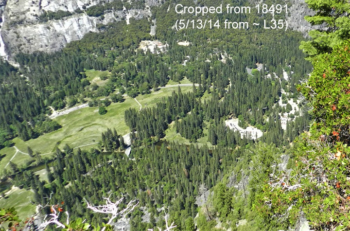
What I call the "long series" of switchbacks (from about 4900', just above the long traverse through the live oaks, to about 6060', just below Union Point) gives lots of views of Yosemite Lodge, Leidig Meadow, and the valley to the west. There's a sort of ridge or dropoff that pretty much blocks views to the east.
Four of the switchbacks in that series do come up to the ridge. Either from those switchbacks themselves or from the rocks just above them, you get views farther east -- Half Dome, the Ahwahnee Meadow, the Village Store, and Day Use Parking.
I didn't remember ever seeing the Sentinel Bridge area from the FMT but it turns out that I do have at least one picture of it, taken from about 6060'. If you see anything of interest, let me know and I can probably get you more pics in a few weeks.

June 15, 2014 09:48PM | Registered: 14 years ago Posts: 675 |

June 16, 2014 06:24PM | Registered: 11 years ago Posts: 299 |
Here are a few shots of the same area from OMG Point, taken the day before. Columbia Rock would be a good viewpoint, too. However, the only pic I happened to take from Columbia Rock with the Sentinel Bridge area in it, was wide-angle and quickly gets blurry when enlarged.


Do you see anything there worth a closer look?
Edited 1 time(s). Last edit at 06/16/2014 06:32PM by gophersnake.
Do you see anything there worth a closer look?
Edited 1 time(s). Last edit at 06/16/2014 06:32PM by gophersnake.
June 16, 2014 11:06PM | Registered: 11 years ago Posts: 299 |
There's also this gigapan from Eagle Peak, which qumqats was kind enough to link me to, a year ago: http://gigapan.com/gigapans/45634
I found this gigapan from Columbia Rock on my own: http://gigapan.com/gigapans/115867 Unfortunately the exposure sucks. The only way I can think of to make use of it, would be to save screen shots of the parts that interest you, then open them in something like Photoshop and adjust the brightness and contrast.
I found this gigapan from Columbia Rock on my own: http://gigapan.com/gigapans/115867 Unfortunately the exposure sucks. The only way I can think of to make use of it, would be to save screen shots of the parts that interest you, then open them in something like Photoshop and adjust the brightness and contrast.
|
Re: Aerial views of the Old Village June 17, 2014 07:50AM | Registered: 13 years ago Posts: 617 |
Thanks for all of this, gophersnake. I'm away at a business conference most of this week and won't have much time to look through this until I get back but, rest assured, I will! FYI, I love these current aerial views but I was mostly looking for shots of the actual Old Village...i.e., the Sentinel Bridge area as it looked when the Village was still there.Quote
gophersnake
Here are a few shots of the same area from OMG Point, taken the day before. Columbia Rock would be a good viewpoint, too. However, the only pic I happened to take from Columbia Rock with the Sentinel Bridge area in it, was wide-angle and quickly gets blurry when enlarged.
Do you see anything there worth a closer look?
June 17, 2014 10:51AM | Registered: 11 years ago Posts: 299 |
You're welcome!  I imagine other people would have taken photos from those viewpoints too, over time. Of course, they may have tried not to include any of the Village in theirs.
Have you already seen this? It's the “'Old' Yosemite Village (Upper Village) building sites, circa 1925-40 [260KB, 1020x1084]" item listed on this page.
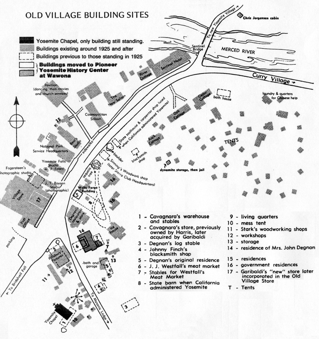
I imagine other people would have taken photos from those viewpoints too, over time. Of course, they may have tried not to include any of the Village in theirs.Have you already seen this? It's the “'Old' Yosemite Village (Upper Village) building sites, circa 1925-40 [260KB, 1020x1084]" item listed on this page.
Sorry, only registered users may post in this forum.

