
I'm happy to report that the trail has been kept open, the pump and electrical equipment have been cleaned off, and there is a big pile of plastic pipe that could be used to fix the winter breaks between the storage tank and the spring. But the tank is empty, and the feeder pipe still broken. I'm guessing that if the new well up at Glacier Point ever dries up, there will be a rush to fix the old system
Looking back at the bushy section, you can see the old iron pipe that used to feed the comfort station and watering trough at Union Point.
 .
.The pump shed is weathering, but the tank (on the left) looks OK:
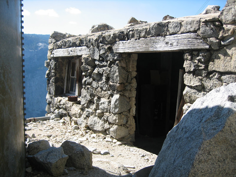
The stuff inside the shed is clean, and looks fine.
The waterfalls were mostly running full, even Ribbon Falls, which has a very small drainage area to feed it. Here is the standard Yosemite Falls view from the Four Mile Trail:

Tuesday was our main hiking day. Since my buddy had never hiked the section of trail from Tamarack Flat to El Capitan, that was our primary goal. But we also wanted to detour via Chick-on Knob to get a view of the Twin Falls of Cascade Creek. One of our favorite places. As you hike up the trail, you get a good view of the knob as you pass by.

When we first tried to figure out how to get to the twin falls in 2012, Chick-on had proposed a route to get there via this knob. He later passed that way as he beat us to the spot. .
See: http://yosemitenews.info/forum/read.php?3,57245,57245#msg-57245
We, of course, took a much longer way to get there in 2013. But it was worth it. This from June three years ago:

For much more about the Twin Falls look here (link). Other than Chick-on and us, I am unaware of anyone who has been there...
As we approached Ribbon Meadow on the way to El Capitan, it became clear why Ribbon Falls was still running. We had seen no snow until now on the hike, but the woods above the falls still held several feet of dense snow. The day was hot, and it was melting like crazy.

After spending an hour or so poking around on the top of El Capitan, we set off for Chick-on Knob, and its promised view.

The bushwhacking down off Chick-on Knob was the worst that I have seen in several years. We were running a bit late, so we didn't do much scouting....we just plunged into it. Bad idea. Here is the whole route. (17 miles. From the lowest to the highest point measured only 2000 vertical feet, but the ups and downs added about another thousand....) On the map, F marks the falls and K marks Chick-on Knob.

We left the established trail at the west end of Ribbon Meadow and cut over to cross the route down from El Cap ridge (link) and close to the Old Mono Trail (link). Familiar territory, but not places to visit on this day trip.
On Wednesday we had to leave around noon, so we did some easy short stuff: We bushwhacked along the cliff from Rostrum (which is closed for peregrine falcon nesting) to Elephant Rock (which is not), then played around on the slick rock of Turtleback Dome. Plus a short stop at the base of The Cascade on the way out of the park. Elephant Rock is very impressive.

Turtleback Dome is always fun to scramble around on. The Cascade is also an interesting place. The old ranger station there has been torn down, and the old trail stonework and pipe rail there have been purposely obscured, but there are still interesting things to be seen. For example, this pair that we saw there on Wednesday:


Edited 2 time(s). Last edit at 06/09/2016 11:45PM by wherever.


