Welcome! Log In Create A New Profile Recent Posts
Tuolumne Meadows and Lembert Dome during a summer storm, Yosemite National Park

The Moon is Waxing Gibbous (59% of Full)


Advanced

Re: Range of Light

All posts are those of the individual authors and the owner of this site does not endorse them. Content should be considered opinion and not fact until verified independently.

avatar Range of Light
February 28, 2017 07:20AM
Been reading "The Yosemite"... read it before quite some time ago...
Didn't realize Pacheco Pass was where he coined Range of Light.


I mean, the guy sure can write prose, not sure I believe everything he says.
Maybe that's blasphemous. I don't know.

Anybody know which one is Tenaya Fall? (one across from Snow Creek) ?

Anyzoo... Been taking notes in the book. More later.


Chick-on is looking at you!
avatar Re: Range of Light
February 28, 2017 09:08AM
You might have to add Muir's Martinerz to Yosemite route to your growing list of TrailQuests...more info here.
Re: Range of Light
February 28, 2017 03:51PM
I puzzled over references to Tenaya Fall(s) when reading "The Incomparable Valley" by Matthes and Fryxell. I've come to understand that it is Tenaya Creek Falls, the cascade a half mile or so (including some bushwacking/scrambling) past the footbridge at the end of the extended Mirror Lake Loop.
http://www.worldwaterfalldatabase.com/waterfall/Tenaya-Falls-7350/
avatar Re: Range of Light
February 28, 2017 04:38PM
Thank you. That is what I thought. The falls across Z way from Snow Creek.
It's gorgeous. I want to look and see if that big oak is still there that Muir describes.
Will have to look thru my pics... and visit again!

Thanks


Chick-on is looking at you!
Re: Range of Light
February 28, 2017 05:15PM
What is considered the official Snow Creek fall? Would that be the section that you can see from the Mirror Lake area, at the SC/Tenaya confluence? Or is it higher up, and cautiously reachable scrambling beyond the long switchback of the SC trail?
avatar Re: Range of Light
February 28, 2017 08:38PM
Sorry, it's Snow Creek Falls

Pretty much it's up higher... and is a set of falls. I'd go with what it shows on USGS.
This is one I took near Tenaya Creek Falls...

Not the best lighting.. o well...


You have to go out further beyond on the long switchback on the Snow Creek Trail to
get a view... and from below on the old trail you can't see it all ...

I'd show.. but it takes awhile to find those... and I'm off for a bit

Have fun


Chick-on is looking at you!
avatar Re: Range of Light
February 28, 2017 10:03PM
Quote
Dave_Ayers
I puzzled over references to Tenaya Fall(s) when reading "The Incomparable Valley" by Matthes and Fryxell. I've come to understand that it is Tenaya Creek Falls, the cascade a half mile or so (including some bushwacking/scrambling) past the footbridge at the end of the extended Mirror Lake Loop.
http://www.worldwaterfalldatabase.com/waterfall/Tenaya-Falls-7350/

I've been up Tenaya Canyon into the 'Narrows' and don't remember Tenaya creek going over cascades as are described or pictured.
Is this Hidden Falls? Or a lower part of Snow Creek Falls?
That webpage seems to be describing Hidden Falls. Does ANY place in Yosemite have only a single name?


Edited 1 time(s). Last edit at 02/28/2017 10:13PM by qumqats.
Re: Range of Light
March 01, 2017 03:19PM
I've seen it called "Hidden Falls" also. A couple of examples are https://www.theoutbound.com/yosemite/hiking/hike-to-hidden-falls-aka-tenaya-creek-falls and http://www.yosemitehikes.com/tioga-road/snow-creek/gallery-hidden-falls.htm . In my limited experience and recollection, it is called Tenaya Fall or Tenaya Falls in the old texts like the Muir and Mathes texts referred to in the thread. Hidden Falls and Tenaya Creek Falls seem to be more recent monikers. Note that there are 4 other falls in California called "Hidden Falls" in the World Waterfall Database to help us all with our confusion.
avatar Re: Range of Light
February 28, 2017 07:52PM
Quote
chick-on
Been reading "The Yosemite"... read it before quite some time ago...
Didn't realize Pacheco Pass was where he coined Range of Light.


I mean, the guy sure can write prose, not sure I believe everything he says.
Maybe that's blasphemous. I don't know.


You might want to snap a photo on a clear day on the actual summit of the historic Pacheco Pass (El. 1497) and not from the far lower in elevation Romero Overlook (El. 619) where this "Pacheco Pass" monument is located before doubting John Muir's veracity. smiling smiley

The actual top of the historic Pacheco Pass where John Muir most likely had trodden is located at the USGS BM 1497 at the Santa Clara County – Merced County border on top of what is now labeled as a "Jeep Trail" on the USGS topo maps.


Leave No Trace
avatar Re: Range of Light
February 28, 2017 08:18PM
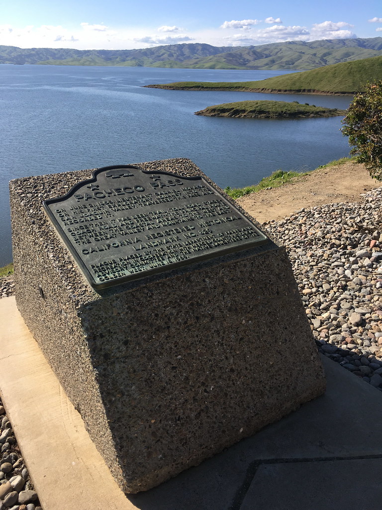
O garsh. Sorry. I wasn't doubting the Range of Light. Being able to see The Sierra from
"The Real Pacheco Pass". I was doubting the Latent Heat of Granite statement, the
all Talus Slopes were created with a single Huge Earthquake, the number of lakes in
the basins, and, let's see, so far, um, The Avalanche story.

Now I'm ok with being wrong and all, but I don't necessarily believe everything I read.
Maybe further analysis will prove he was right all the time. But I want to look into these
things more.

Thanks for the map. I may just do that. I'm sorry I didn't stop at the visitor center in the
past when the water was low. I regret that. Though I don't usually go Pacheco Pass.
That is been the MO this year with hitting SEKI.

Anywho, thanks


Chick-on is looking at you!
Sorry, only registered users may post in this forum.

Click here to login