For 67 years I've visited Yosemite at least once a year. I even worked two years for YP&CCo. in the early 70's. Now that I'm retired I am trying to learn as much of the history of Yosemite as I can. I've read several books and Googled many sites. Some questions I still have not found answers and thought this forum may be able to help. Three that come to mind are-------
1. What's the story of the rail fence on north side drive at Devil's Elbow?
2. Where was the exact location of Lower Iron Bridge?
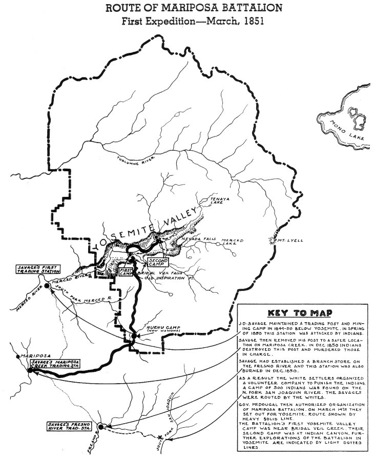
3. Where did the Mariposa Battalion make their first camp? On the west side of the moraine in Bridalveil Meadow or the east side near Bridalveil creek?

The Moon is Waxing Gibbous (62% of Full)
Re: Yosemite History
All posts are those of the individual authors and the owner
of this site does not endorse them. Content should be considered opinion
and not fact until verified independently.
|
Yosemite History January 31, 2019 10:34AM | Registered: 11 years ago Posts: 52 |
|
Re: Yosemite History January 31, 2019 07:34PM | Registered: 13 years ago Posts: 617 |
February 01, 2019 07:19AM | Moderator Registered: 14 years ago Posts: 7,421 |
I'd say I'm on exurt on trails n such... but not so much on the history.
Yosemite has a LOT of history and a lot of it is hard to discern.
I'll try though since I'm not in my beloved now or heading there until next week.
1. Too much foot traffic eroding the banks.... ? Probably not much of a story.
2. Never heard of... you've peaked my interest... I'll look into...
3. The Discory of The Yosemite by Bunnnell isn't really clear...
I was originally thinking that they camped due north of Birdalveil Fall due to them
headlining west the next day to ford the river. And also looking east on
the day they arrived for another ford spot. You'd want to ford across near
Bridalveil Meadow and camping in it I wouldn't say I went downstream.
The area due north of the fall is really nice, as you know.
Maybe the answer is more they camped near the present day parking lot
of the fall.
It's really hard to tell.
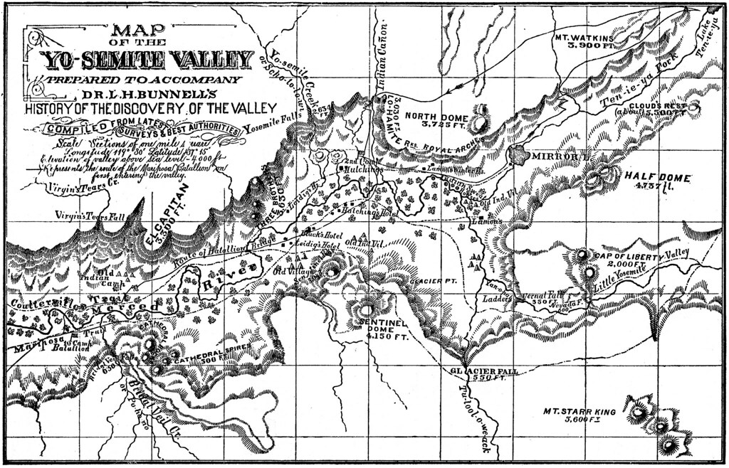
Here's a map I found in my zillion map collection … Not sure it's entirely clear.
Could try putting an overlay on it... but it's pretty …

Yosemite has a LOT of history and a lot of it is hard to discern.
I'll try though since I'm not in my beloved now or heading there until next week.
1. Too much foot traffic eroding the banks.... ? Probably not much of a story.
2. Never heard of... you've peaked my interest... I'll look into...
3. The Discory of The Yosemite by Bunnnell isn't really clear...
I was originally thinking that they camped due north of Birdalveil Fall due to them
headlining west the next day to ford the river. And also looking east on
the day they arrived for another ford spot. You'd want to ford across near
Bridalveil Meadow and camping in it I wouldn't say I went downstream.
The area due north of the fall is really nice, as you know.
Maybe the answer is more they camped near the present day parking lot
of the fall.
It's really hard to tell.
Here's a map I found in my zillion map collection … Not sure it's entirely clear.
Could try putting an overlay on it... but it's pretty …
February 01, 2019 07:23AM | Moderator Registered: 14 years ago Posts: 7,421 |
February 01, 2019 07:26AM | Moderator Registered: 14 years ago Posts: 7,421 |
From:
"Early Years In Yosemite" (1926 by Carl P. Russell)
On March 25, 1851, the party went into camp near Bridal Veil Fall. That night around the camp fire a suitable name for the remarkable valley was discussed. Lafayette H. Bunnell, a young man upon whom the surroundings and events had made a deeper impression than
upon any of the others, urged that it be named Yosemite, after the natives who had been driven out. This name was agreed upon. Although the whites knew the name of the tribe, they were apparently unaware that the Indians had another name, Ahwahnee, for the Valley.
The next morning the camp was moved to the mouth of Indian Canyon, and the day was spent in exploring the Valley. Only one Indian was found, an ancient squaw, too feeble to escape. Parties penetrated Tenaya Canyon above Mirror Lake, ascended the Merced Canyon beyond Nevada Fall, and explored both to the north and to the south of the river on the Valley floor. No more Indians were discovered, and on the third day the party withdrew from the Valley. The Indians who had been gathered while the party was on the way to the Valley escaped from their guard while en route to the Indian Commissioner’s camp on the Fresno; so this first expedition accomplished nothing in the way of subduing the Yosemites.
February 01, 2019 07:32AM | Moderator Registered: 14 years ago Posts: 7,421 |
You "need" to read:
historic Resource Study
YOSEMITE: THE PARK AND ITS RESOURCES
A History of the Discovery, Management, and Physical Development of Yosemite National Park, California
Volume 1 of 3 Historical Narrative
by Linda Wedel Greene
This 3 set will keep you busy for a VERY long time.
The first map came from there it looks like. There are so many references in there...
Have fun!
February 01, 2019 07:33AM | Moderator Registered: 14 years ago Posts: 7,421 |
Searching it finds the answer to your first question:
Access to the valley was one of the main problems addressed
after establishment of the grant. From the north, travelers on horseback
usually took the seventeen-mile wagon road from Coulterville to Black's
Hotel at Bull Creek, where they stayed overnight, covering the
thirty-two miles into Yosemite Valley the next day. These travelers had
to pay to cross the Merced River on Ira Folsom's ferry, three-fourths of
a mile below the Lower Hotel. The only alternative was to follow an
unsatisfactory trail farther up the valley on the north side and cross the
Merced over a log bridge Hutchings had erected prior to 1865 opposite his
hotel, between Yosemite Fall and Sentinel Rock, replacing the crude log
structure Hite built in 1859. In order to improve this situation, the
Yosemite commissioners prior to 1866-67 erected a good saddle horse
bridge across the Merced at the foot of Bridalveil Meadow, near where the
trail from the north entered the valley. This Lower Iron Bridge (later
Pohono Bridge) enabled visitors to make a full circuit tour of the valley if
desired, without the delay and expense of the ferry ride.
February 01, 2019 07:47AM | Moderator Registered: 14 years ago Posts: 7,421 |
Ok. I get what you're asking now about Lower Iron Bridge...
from Greene:
By 1894 the Lower Iron Bridge across the Merced River
near where the Big Oak Flat Road entered the valley still had not been
rebuilt after collapsing from snow loads years before. That situation
forced travelers to follow along the north side of the valley to the Upper
Iron Bridge spanning the river almost directly opposite Yosemite Fall.
So... bear with me... you can find the abutments still nowadays...
but that bridge was never rebuilt.
I think that is what you are looking for... On 1912 maps it hmm...
dang... it shows as El Cap Bridge. Did they rebuild?
Ok, now I'm confused.
It must have gotten whacked again. Anyway, that can be found
around current USGS BM 3954.
I have some pictures of what it looked like maybe 5 years ago.
Can find them if you're interested.
Hope made sense.
|
Re: Yosemite History February 01, 2019 08:10AM | Registered: 9 years ago Posts: 166 |
Quote
chick-on
Another one:
Thank you for posting this. From a cartographic perspective, I really like this map. It's simple but, but the objective is clearly demonstrated in the map, and the hachures, the font of "key to map", they are really well done.
(As a side, been watching the AMC series Hell on Wheels which is a fictional story based on the building of the transcontinental railroad. Gives one a visual sense of the Indian attacks)
|
Re: Yosemite History February 01, 2019 07:42AM | Registered: 11 years ago Posts: 52 |
February 01, 2019 07:48AM | Moderator Registered: 14 years ago Posts: 7,421 |
Quote
Pohono
chick-on---So it appears from the valley map that the first camp was on the west side of the moraine near the present Bunnell marker. And the Lower Iron Bridge became the Pohono Bridge. But I'm still puzzled about the rail fence. I will definitely hunt down the Linda Greene book. Thanks
I replied more. Have fun!
I woke up last night longing for the mountains.
Sigh

February 01, 2019 07:49AM | Moderator Registered: 14 years ago Posts: 7,421 |
|
Re: Yosemite History February 01, 2019 03:13PM | Moderator Registered: 13 years ago Posts: 864 |
I don't think the rail fence at Devil's Elbow will be mentioned in the Greene book--it is fairly recent, perhaps in the last 15-20 years. I think it was built simply to prevent erosion of the riverbank due to foot traffic; I also remember a picnic area there (and one south of Northside Drive, perhaps near Eagle Creek--I remember JKW and I did homework in college while parked there...)
It's possible that the information about project to build the fence it is on the NPS planning website, which unfortunately has not been restored yet post-shutdown. I would guess that it is also mentioned in the planning documents for the Merced River Plan, which extensively documented many existing features along the river.
It's possible that the information about project to build the fence it is on the NPS planning website, which unfortunately has not been restored yet post-shutdown. I would guess that it is also mentioned in the planning documents for the Merced River Plan, which extensively documented many existing features along the river.
February 01, 2019 06:41PM | Registered: 15 years ago Posts: 4,173 |
The rail fence at Devil's Elbow was part of a restoration project that was started in 1993 and completed, IIRC, the next year. Here's more information on the Devil's Elbow restoration project and its success in rehabilitating that part of the Merced:
https://www.fs.fed.us/eng/pubs/html/04231201/page22.htm
Leave No Trace
Edited 1 time(s). Last edit at 02/01/2019 08:36PM by plawrence.
https://www.fs.fed.us/eng/pubs/html/04231201/page22.htm
Leave No Trace
Edited 1 time(s). Last edit at 02/01/2019 08:36PM by plawrence.
|
Re: Yosemite History February 01, 2019 07:33PM | Registered: 11 years ago Posts: 52 |
February 04, 2019 07:33AM | Moderator Registered: 14 years ago Posts: 7,421 |
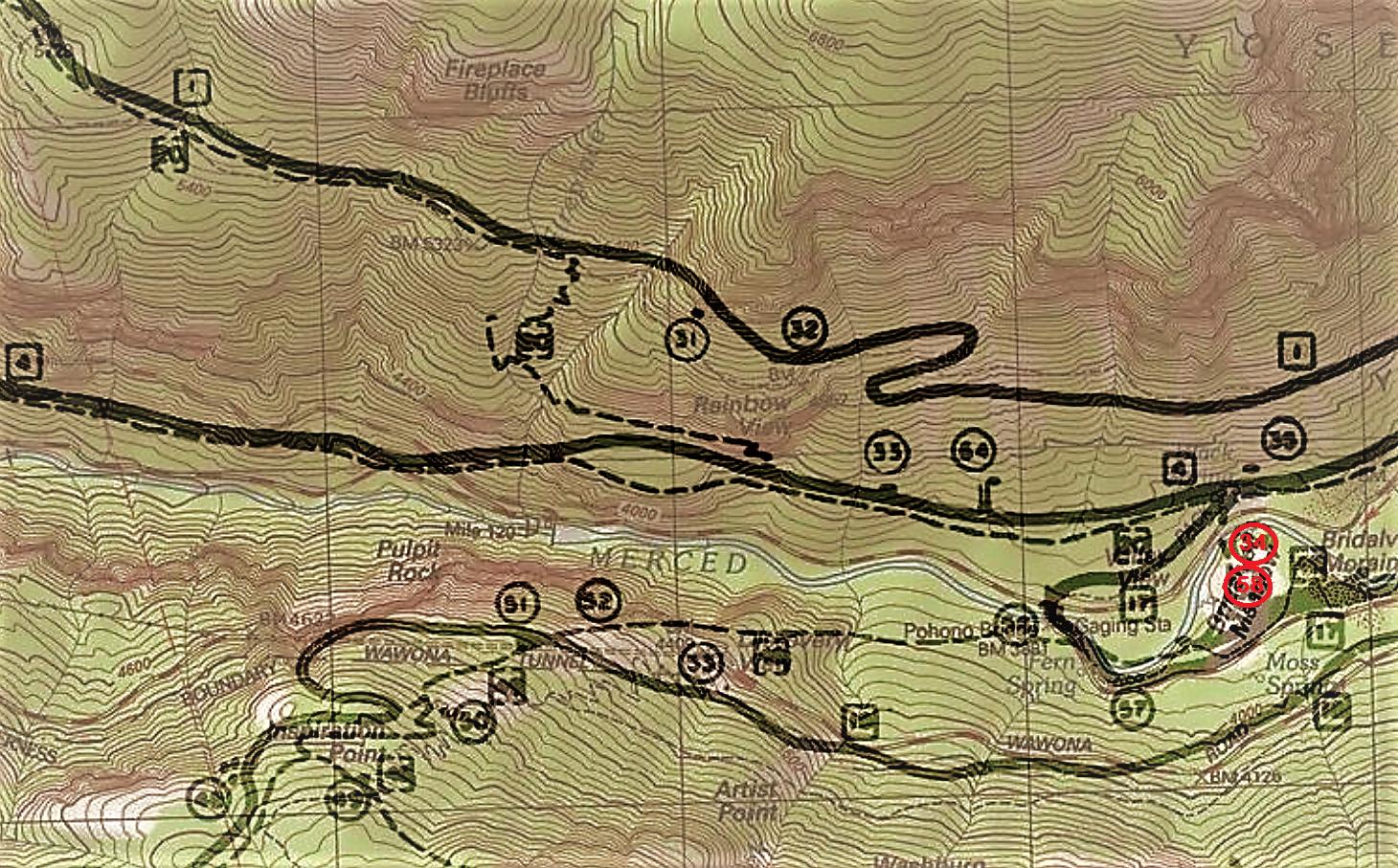
If you've been around this forum a long time... you may recall I dooz an overlay of Greene's base map...
It actually has the locations of the ford and the first camp. It effectively says Roosevelt and the first battalion
camped at the same location.
Here is the map for the valley overlayed:

and here I cropped and made 34 and 58 show up …
34 = ford
58 = first camp spot
I'll let you go get the doc for the rest of the key.
It's very interesting on account it clearly says Old Inspiration is Mt. Beautitude.
(there was a rather long discusson on this topic... and such)
Anyway, ask more. Or … just have fun.
It actually has the locations of the ford and the first camp. It effectively says Roosevelt and the first battalion
camped at the same location.
Here is the map for the valley overlayed:
and here I cropped and made 34 and 58 show up …
34 = ford
58 = first camp spot
I'll let you go get the doc for the rest of the key.
It's very interesting on account it clearly says Old Inspiration is Mt. Beautitude.
(there was a rather long discusson on this topic... and such)
Anyway, ask more. Or … just have fun.
|
Re: Yosemite History February 05, 2019 01:05PM | Registered: 11 years ago Posts: 52 |
Sorry, only registered users may post in this forum.

