Summertime in the Eastern Sierra brings beautiful weather and many times that means thunderstorms that are welcome as they cool off the afternoons and bring much needed rain. Thunderstorms also mean lightning. Last week the Inyo received a lot of rain and hundreds of lightning strikes. Five small lightning ignited fires were discovered across the Inyo National Forest after the storms and rain moved out.
The Mills Fire was located on the eastern side of the Mono Craters in sparse fuels surrounded by pumice. One engine crew responded to the fire where it was discovered that it had all but gone out after heavy rain doused the area. There will be no further reports on this fire.
The Kelty Fire is located in Kelty Meadows at 9000’ in the Glass Mountains. This fire is less than 1/10th of an acre. Yesterday two engine crews reported the fire was smoldering with minimal activity. Crews will continue to monitor the fire and there will be no other reports unless significant activity occurs.
The Cow Fire is in the Golden Trout Wilderness, southwest of Fat Cow Meadow. The fire is less than 1 acre in size burning at an elevation of 9,500 feet. A helicopter was used to bring in ground crews who reported that the fire is smoldering with minimal activity. “The safety of firefighters and public are the number one priority on all fires, said Inyo National Forest Supervisor Tammy Randall-Parker. Every fire start is carefully evaluated to weigh the benefits to manage the fire to reduce fuels, increase bio-diversity and improve wildlife habitat”. Due to the remoteness of this fire, firefighters will scout areas where natural barriers can be used to contain the fire if needed. This tactic will also benefit the wilderness by helping to restore a more natural and resilient fire dependent ecosystem. Updates will be provided as needed.
The Pond Lily Fire is located west of Devils Postpile and Mammoth Lakes in the John Muir Wilderness between Cold Creek and Pond Lily Lake. The fire is being suppressed using ground crews, smokejumpers, and 2 large Type 1 helicopters due to the proximity to the John Muir Trail. The fire is 7.2 acres in size. The Incident Commander, Jayson Smith, reported moderate fire activity yesterday and that the helicopters made good progress cooling the fire off to allow the smokejumpers and engine crews to get line construction started. Further updates on this fire will be provided
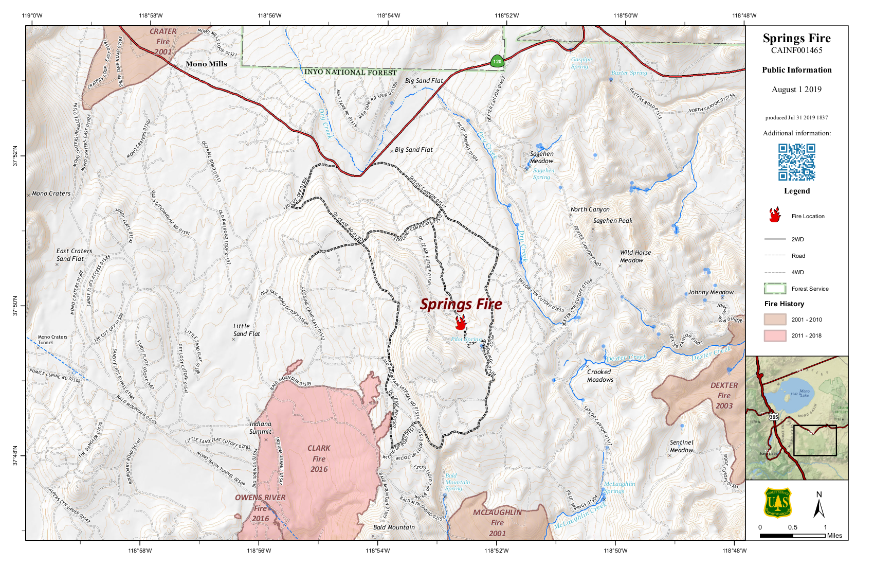
The Springs Fire is located near Pilot Springs, south of Highway 120 East and east of the Mono Craters. This area has seen numerous previous prescribed fires and mechanical thinning treatments. Forest Managers are considering using this fire to continue to further restore ecosystems that are dependent on fire for health and regeneration as well as community protection from future fires. 2,000 to 3,000 acres are being considered for these purposes as 2 engine crews on scene have reported low intensity fire behavior that would make this favorable for fire to reenter the area bringing multiple benefits. Expect frequent updates on the Springs in the days to come.
As mentioned above, the Inyo received hundreds of lightning strikes and management expects “sleeper” fires to pop-up as the week continues to provide ample sunshine that will dry out rain soaked vegetation and fuels.
All posts are those of the individual authors and the owner
of this site does not endorse them. Content should be considered opinion
and not fact until verified independently.
July 29, 2019 11:57AM | Admin Registered: 15 years ago Posts: 17,051 |
July 30, 2019 06:01PM | Admin Registered: 15 years ago Posts: 17,051 |
Fire in the Eastern Sierra and on the Inyo National Forest is a frequent and essential natural event that ecosystems and wildland urban interface communities rely on to develop resiliency to future potentially catastrophic, unwanted wildfires. Low intensity lightning caused fires restore and maintain forest health, and biodiversity while creating sustainable recreation opportunities into the future. Every naturally ignited fire is evaluated carefully with public, firefighter, and infrastructure safety as the top priority.
The lightning caused Cow fire is southwest of Fat Cow Meadow within the Golden Trout Wilderness. The fire is about an acre in size and smoldering at an elevation of 9,500 feet in mixed conifer. This area has not seen fire in recorded history. Due to low fire behavior and remoteness, fire personnel have been monitoring it with a helicopter and small fire crew to determine appropriate containment options, utilizing minimum impact fire suppression tactics and natural barriers such as granite ridges and wet, green meadows.
The lightning caused Pond Lily fire is 8 acres and located west of Devils Postpile and Mammoth Lakes in the John Muir Wilderness between Cold Creek and Pond Lily Lake. This is being aggressively suppressed due to its proximity to the John Muir Trail. Fire resources that worked the fire throughout the day yesterday were 7 smokejumpers, 2 large Type 1 helicopters, one Type 2 helicopter, 1 Type 3 helicopter, 1 hotshot crew, 5 helicopter personnel, and 1 five person engine crew. The Incident Commander, Jayson Smith, reported excellent progress was made constructing line and that the fire is currently 50% contained with both hand line construction and a hose line expected to be completed around the fire perimeter by today. The Incident Commander anticipates releasing the smokejumpers and engine crew Wednesday. Further updates on this fire will be provided as containment increases.
The lightning caused Springs fire is located near Pilot Springs, south of Highway 120 East and east of the Mono Craters. This area has seen numerous previous prescribed fires, mechanical thinning and logging treatments. The fire is currently 1.15 acres and smoldering in Lodgepole pine and mixed conifer. Inyo National Forest Interagency Fire Management Officer, Taro Pusina states that, “We are seeking to take advantage of one of the wettest winters on record, abundant firefighting resources and relatively few regional wildfires to appropriately respond to a lightning fire and safely reintroduce fire to an area that historically received frequent fire”. A containment area of approximately 2,000 to 3,000 acres is being considered for the purpose of managing for multiple objectives including protection, suppression and resource benefit. There are 2 Type 1 wildland fire modules currently assigned to this incident, with more resources on order and arriving through the day today. Forest managers will work closely with the Great Basin Unified Air Pollution Control District to ensure that potential smoke impacts to nearby communities and recreation areas are limited and mitigated to the extent possible. Expect smoke to be visible along Hwy. 120 east and in and around Mono Lake. Adjacent recreation roads may be temporarily impacted and or closed for use by firefighters and equipment. Regular updates will be provided on the Springs fire.
August 01, 2019 12:10PM | Admin Registered: 15 years ago Posts: 17,051 |
The Inyo National Forest has mobilized its Type 3 Interagency Incident Management Organization for the planning and implementation of the Springs fire, as well as provide support for other incidents on the Inyo. The Owens Valley Interagency Communication Center is now staffed 24 hours a day, with additional team members arriving to assist today. The dispatch center is integral to fire operations and facilitates ordering the necessary operational, logistical and overhead support needed to respond to all lightning and human caused wildland fires on the Inyo National Forest and Bureau of Land Management Bishop Field Office. In addition to firefighters, other logistical orders placed include such items as water and sports drinks, hand washing stations, toilets, and food. Every naturally ignited fire is evaluated carefully with public, firefighter, and infrastructure safety as the top priority.
The lightning caused Pond Lily fire west of Devils Postpile and Mammoth Lakes has been suppressed due to its proximity to the John Muir Trail and is over 75% contained and 8 acres in size. The Incident Commander anticipates releasing the majority of firefighters by the end of shift today. Further updates on this fire will be provided as containment increases.
The lightning caused Springs fire is located near Pilot Springs, south of Highway 120 East and east of the Mono Craters. This area has seen numerous previous prescribed fires, mechanical thinning and logging treatments. The fire size increased to 1.4 acres today and is smoldering with a low rate of spread in Lodgepole pine and mixed conifer. The primary objective on the Springs fire is firefighter and public safety. It is also being managed for resource objectives in an effort to restore and maintain fire dependent ecosystems and build resilience to future potentially catastrophic wildfires. Inyo Forest is taking advantage of one of the wettest winters on record. There are few regional and national wildfires and there are many regional and national wildland fire resources available to assist. The anticipated final fire size is approximately 2,000-3,000 acres. There are two Type 1 wildland fire modules, four Type 3 fire engines, and two tactical water tenders currently assigned to this incident. Forest managers will work closely with the Great Basin Unified Air Pollution Control District, Caltrans and nearby stakeholders to ensure that potential smoke impacts to nearby communities and recreation areas are limited and mitigated to the extent possible. Expect smoke to be visible along Hwy. 120 east and in and around Mono Lake. Visitors and recreationalist should avoid using roads close to the fire and are asked to stay away from the immediate area in order to help keep firefighters, equipment, and themselves safe. Regular updates will be provided on the Springs fire.
August 02, 2019 02:38PM | Admin Registered: 15 years ago Posts: 17,051 |
The Inyo National Forest has been aggressively suppressing and monitoring several natural lightning caused wildfires in the past week. Things have settled down and there is no new activity to report on the Kelty and Cow fires. Fire activity is increasing on the Springs fire, and firefighters are strengthening containment lines by cutting hazardous trees and installing fire hose and portable water tanks around the fire. This will reduce some of the risk associated with responding to wildland fires. Safety of the public, firefighters, and infrastructure is always the top priority.
The lightning caused Pond Lily fire west of Devils Postpile and Mammoth Lakes has been suppressed due to its proximity to the John Muir Trail and is 90% contained and 8 acres in size. The Incident Commander anticipates releasing the smokejumpers assigned to the fire today. Remaining resources will back haul hose and suppression supplies Friday, with all resources released at end of shift Friday. The fire will be put into patrol status at that time. This will be the last update for this fire.
The lightning caused Springs fire is located near Pilot Springs, south of Highway 120 East and east of the Mono Craters. The fire size increased to 1.5 acres today and is smoldering, creeping and burning with low spread rates in Lodgepole pine and mixed conifer. This fuel type and area historically received natural lightning caused fires every 15 -50 years and relies on fire to regenerate and maintain a healthy, fire dependent environment. The lead forest resource advisor for this incident, Jacquie Biedl, states “The Springs fire has given us the benefit of time to get out in front of the fire in order to identify and protect fire sensitive cultural sites and other natural resources at risk”. Firefighters will be conducting tactical firing and burnout operations to containment lines and anticipate 25 to 30 acres of growth today. This critical operation will keep the fire from spreading east into much more dense and continuous vegetation and fuels and allow for a strong anchor point in anticipation of the fires continued growth. There will be road closures proximate to the fire and forest users are asked to avoid the area to keep firefighters, equipment, and themselves safe. Forest managers are working closely with the Great Basin Unified Air Pollution Control District, Caltrans and adjacent stakeholders to ensure that potential smoke impacts to nearby communities and recreation areas are limited and mitigated to the extent possible. Expect smoke to be visible along Hwy. 120 east and in and around Mono Lake. Regular updates will be provided on the Springs fire.
August 02, 2019 02:43PM | Admin Registered: 15 years ago Posts: 17,051 |
August 05, 2019 10:33AM | Admin Registered: 15 years ago Posts: 17,051 |
Current Situation: The Inyo National Forest Type 3 Incident Management Organization is managing the Springs Fire. Crews made good progress yesterday in control line construction on the eastern flank of the fire, limiting fire spread into Pilot Dry Creek. Most of yesterday’s 20 acres of fire growth was a result of tactical burning operations firefighters used to remove vegetation between indirect fire lines and the main fire. This provides more depth to the control line to secure an established anchor point. Fire managers and crews on the fireline anticipate a growth of 25-30 acres today. A Type 1 KMAX helicopter is now assigned to the Springs fire on a call when needed basis. The Springs fire Communications Unit plays a vital role in all functions working on the fire. The unit currently consists of 5 personnel; a Communications Unit Leader, Communications Technician, Incident Communications Manager and Radio Operators. They are staffed to monitor all radio traffic on the incident 24 hours a day. On Monday, July 29, the communications unit had already set up 2 mobile command repeaters, providing coverage for the entire fire area. This gives the communication unit the ability to log all radio traffic on the incident, pass messages from the fireline to incident command staff, and allow all firefighters on the incident to communicate with each other for critical fire operations. They program radios for incident personnel, develop the communication plan with correct frequencies for radio traffic, and repair incident radios when needed.
Soft Closure Order: A soft closure order is in effect for some roads leading into the Springs fire to provide for public and firefighter safety. Forest Roads 1S17 from HWY 120 East to the Junction of 1S04. Forest Road 1S04 is closed from Forest Road 1S17 junction to Forest Road 1S02. Forest Road 1S12 is closed from the 1S17 junction to 1S02. The Springs Fire Incident Commander asks that all motorists observe and obey all posted signs and barricades to ensure for the safety of all public and firefighters.
Inciweb: https://inciweb.nwcg.gov/incident/6477/
August 05, 2019 01:37PM | Admin Registered: 15 years ago Posts: 17,051 |
The Inyo National Forest Type 3 Incident Management Organization is managing the Springs Fire. Fire behavior increased early afternoon yesterday, changing tactical priorities to holding and mop-up through the day. Several resources on day shift were called in to rest and transitioned into night shift to complete operational objectives. Crews currently assigned on night shift are a wildland fire module, two Type 3 engines, one Type 6 engine, two tactical water tenders, a patrol, and a fireline emergency medical technician. Fire crews were able to secure 50 acres of line through the night employing tactical firing operations ahead of the main fire. This provides more depth to the control line to secure an established anchor point. Fire managers and crews on the fireline anticipate a growth of 50-60 acres today. A Type 1 KMAX helicopter is now assigned to the Springs fire on a call when needed basis. Fire management have based strategic and tactical decision making on historical and scientific data for the purpose of managing for multiple objectives including protection, suppression and resource benefit. The Who’s Who of the Incident Management Organization: The Springs fire Finance Section Chief has a huge responsibility on this incident and in most Type 3 organizations. When they arrive at the incident, they have to create the accounting system that tracks all costs for the incident. They can have a time recorder, equipment time recorder, comp/claims, and cost personnel all working underneath them. However, the Finance Section Chief is typically filling all those roles in the Type 3 organization. The system most commonly used is a computer program called E-Isuite. They input all the accounting codes, track all personnel working the fire and those on order to arrive, and the qualifications they are being ordered as to determine the correct pay. This system tracks everyone and also allows the plans section to build the Incident Action Plan (IAP). The finance section is also responsible for outside vendors/contractors, administratively determined (AD), and casual hires. All incident personnel must turn in a daily crew time report (CTR) or shift ticket, which is signed by the unit supervisor. The finance section inputs all those times into the program. Through E-isuite, a daily cost report is ran for the incident. This is a demanding position and requires a lot from the people working in this function. They make sure everyone the incident is paid appropriately and on time.
Soft Closure Order: A soft closure order is in effect for some roads leading into the Springs fire to provide for public and firefighter safety. Forest Roads 1S17 from HWY 120 East to the Junction of 1S04. Forest Road 1S04 is closed from Forest Road 1S17 junction to Forest Road 1S02. Forest Road 1S12 is closed from the 1S17 junction to 1S02. The Springs Fire Incident Commander asks that all motorists observe and obey all posted signs and barricades to ensure for the safety of all public and firefighters.
Inciweb: https://inciweb.nwcg.gov/incident/6477/
August 07, 2019 12:26PM | Admin Registered: 15 years ago Posts: 17,051 |
Current Situation: The Inyo National Forest Type 3 Incident Management Organization is managing the Springs Fire. Firefighters continued with holding and mop-up operations through the day. Crews assigned to night shift continued with tactical firing operations, for a total fire growth of 69 acres yesterday. This continues to provide more depth to the control line securing the established anchor point. A cold front is expected to move through the area today and possibly linger into tomorrow, bringing the potential for strong downdraft and erratic winds. Fire managers and crews on the fireline anticipate a growth of approximately 60 acres today, dependent upon the incoming cold front. Early morning light smoke/haze is also likely farther down the hill toward the Benton/Hammil Valley area, possibly as far as the Bishop/Owens Valley. Fire management have based strategic and tactical decision making on historical and scientific data for the purpose of managing for multiple objectives including protection, suppression and resource benefit.
The Who’s Who of the Incident Management Organization: Every Type 1, 2, and 3 Incident Management Organization must have a Medical Unit Leader. The medical unit provides for basic needs at camp, with some units able to go as far as providing cortisone shots for severe poison oak reactions. The basic supplies provided are things such as antihistamines, foot powder, bandages, lotion, and sunblock. These basic necessities provided make a huge difference for a firefighter working away from home for weeks at a time. The Medical Unit Leader also manages the line Paramedics and Emergency Medical Technicians that are on the fireline for all operational shifts. They render immediate care for any injury that happens, from a twisted ankle or bee sting to a hazard tree falling on a firefighter. The safety of our firefighters is always the top priority on any incident. The Medical Unit plays a critical role in providing medical care to all personnel on the incident.
Soft Closure Order: A soft closure order is in effect for some roads leading into the Springs fire to provide for public and firefighter safety. Forest Roads 1S17 from HWY 120 East to the Junction of 1S04. Forest Road 1S04 is closed from Forest Road 1S17 junction to Forest Road 1S02. Forest Road 1S12 is closed from the 1S17 junction to 1S02. The Springs Fire Incident Commander asks that all motorists observe and obey all posted signs and barricades to ensure for the safety of all public and firefighters.
https://inciweb.nwcg.gov/incident/6477/
|
Re: Wide Spread Thunderstorms Ignite Multiple Fires August 07, 2019 07:51PM | Registered: 13 years ago Posts: 693 |
August 08, 2019 03:44PM | Admin Registered: 15 years ago Posts: 17,051 |
Current Situation: The Inyo National Forest Type 3 Incident Management Organization is managing the Springs Fire. Firefighters continued with holding and mop-up operations through the day. Crews assigned to night shift continued with tactical firing operations, for a total fire growth of 91 acres yesterday. This continues to provide more depth to the control line securing the established anchor point. Afternoon thunderstorms are expected to bring strong downdraft and erratic winds, beginning around 1 p.m. today. Fire managers and crews on the fireline anticipate a growth of approximately 60-70 acres today. Early morning light smoke/haze is also likely farther down east toward the Benton/Hammil Valley area, possibly as far as the Bishop/Owens Valley. Fire management have based strategic and tactical decision making on historical and scientific data for the purpose of managing for multiple objectives including protection, suppression and resource benefit. Springs fire updates will be going to once a day, beginning today. The next update will be sent out on Saturday August 10, 2019.
The Who’s Who of the Incident Management Organization: The Springs fire incorporated an Air Resources Advisor and trainee into their Incident Management Organization. The Air Resources Advisor is responsible for the daily smoke outlook. Meteorology and fire activity (emissions) are used to determining where smoke might accumulate. The smoke likes to follow wind, and sink in evenings into low lying valleys. There are several permanent smoke monitors in the area, and two new temporary monitors were just installed in June Lake and Benton to monitor Springs fire smoke. They also collaborate with the local Air Pollution Control District for any incident they are on. They look at hourly smoke data to see where the smoke has been, where it is, and predict where it will go along with how dense it will be. The daily smoke outlook will tell you the overall Air Quality Index (AQI), and give the best information they have about the likely hourly pattern (Nowcast) of smoke, so you can avoid it.
Soft Closure Order: A soft closure order is in effect for some roads leading into the Springs fire to provide for public and firefighter safety. Forest Roads 1S17 from HWY 120 East to the Junction of 1S04. Forest Road 1S04 is closed from Forest Road 1S17 junction to Forest Road 1S02. Forest Road 1S12 is closed from the 1S17 junction to 1S02. The Springs Fire Incident Commander asks that all motorists observe and obey all posted signs and barricades to ensure for the safety of all public and firefighters.
Inciweb: https://inciweb.nwcg.gov/incident/6477/
Sorry, only registered users may post in this forum.

