Welcome! Log In Create A New Profile Recent Posts
Yosemite Falls

The Moon is Waxing Gibbous (54% of Full)

JanSport - Accept no Imitations. The Original Backpack since 1967.


Advanced

Re: Pre-1970's Yosemite Campground Numbers

All posts are those of the individual authors and the owner of this site does not endorse them. Content should be considered opinion and not fact until verified independently.

avatar Pre-1970's Yosemite Campground Numbers
July 22, 2020 10:45AM
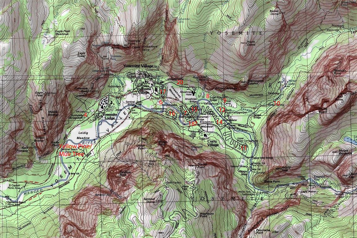
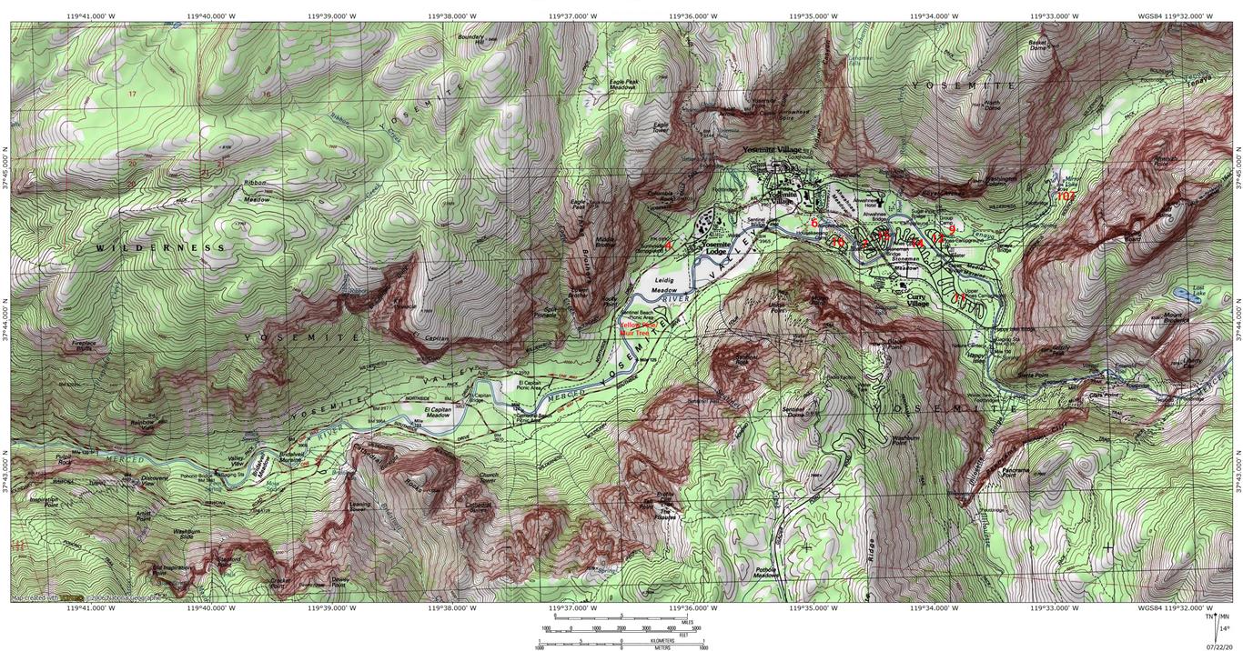
Hi all! Longtime lurker on this site but I have a number of questions and I reckon it was time to find some answers. My dad is now 77 and his family has been camping in Yosemite since before he was born. He has yet to miss a summer of spending at least a week in the valley. We just got back from another week, having stayed at Curry instead of our usual homestead in housekeeping. While we were there we got to discussing the old number designations that once identified the valley's campgrounds. He and I worked it a number of them, and, after consulting a few maps, figured out a couple more. Here is what we have thus far:


So, my questions then center on the rest of the numbers not present. Were there camps 1-3, 5, 8 and 13?

My dad recollects that camp 10 was located near Mirror Lake. He thought is was on the southeast side but his memory is foggy. He may not have been around when the camp was present and his uncles could have told him about it.

Did the Yellow Pine/Muir Tree campground have a number designation? (Also, is the tree or its remnants still there? I know the campground is still extant.)

It seems likely there would have been some campgrounds in the west part of the valley, could the missing numbers (especially 1-3) be located over there?

Did the Lodge and Curry once carry numbers?

I think it is interesting that Yellow Pine, camp 6 and camp 9 all evolved into group camps or employee camps. I remember as a kid seeing the employee tents at camp 6 across the river from housekeeping. My dad and I have resolved to call the new day use parking area over there "camp 6 parking".

Any help in answering the questions is much appreciated!
Re: Pre-1970's Yosemite Campground Numbers
July 23, 2020 11:25AM
If you really want to geek-out on old Yos maps, look here: http://www.yosemite.ca.us/library/maps/

Quickly looking, here's an old one with a few more camp numbers: http://www.yosemite.ca.us/library/yosemite_resources/images/illustration_67.png

It's also a great way to find old trails and points of interest that are now off-map.
avatar Re: Pre-1970's Yosemite Campground Numbers
July 24, 2020 06:41PM
That is an awesome resource! Thank you!
Re: Pre-1970's Yosemite Campground Numbers
July 27, 2020 08:26AM
According to the Schaffer book there was no Camp 13, and I think Schaffer claims that Camp 14 was in the former Iron Spring area (which is still on the USGS maps between the Tenaya Creek bridge and Mirror Lake).
avatar Re: Pre-1970's Yosemite Campground Numbers
July 27, 2020 11:04AM
This is veering off topic a bit, but is there a reason you specifically linked to the 2000 version of Schaffer's book? I have the 2006 version and am wondering if it's worth it to get the older one, too.
Re: Pre-1970's Yosemite Campground Numbers
July 27, 2020 01:15PM
Nope, just grabbed the first hit in the search. I have an old (1990's?) edition and a more recent one (2010-ish) and there are some relatively minor differences: the older one covers Poopenaut Valley, suggesting it as a way to get a quick dip in the Tuolumne after a hike (while downplaying the long, hot, steep climb back to the car...); the newer one replaces this hike with Preston Falls. And the newer one also includes a few cross-country options that were not in the older version. Unless the current version has the post-DNC concessionaire place names (Majestic Hotel, Half Dome Village, etc.), I'd get it. It'll have more up-to-date information on rules and regulations (food storage, permits, etc.)
Re: Pre-1970's Yosemite Campground Numbers
July 28, 2020 04:18AM
I think the most recent edition is from 2006. It's been republished since then (I think I bought mine in 2013 or so) but I don't think it's been updated. Not that's so critical for the trails, but some of the contact info and procedures have changed in the interim (e.g. the need for HD permits).
avatar Re: Pre-1970's Yosemite Campground Numbers
July 28, 2020 12:02PM
Thanks to both of you. I guess Schaffer is probably the "definitive" guide to Yosemite, but that doesn't mean his book is all-encompassing.
Re: Pre-1970's Yosemite Campground Numbers
July 31, 2020 04:41PM
Pretty sure camp 14 is lower pines
avatar Re: Pre-1970's Yosemite Campground Numbers
August 04, 2020 09:08PM
Here is what I have been able to piece together thus far:


A lot of these are well known. However, Camps 20 and 8 are somewhat mysterious to me and I can only reckon their existence from maps and no more. Camp 10 near Mirror Lake was identified via Schaffer's book (great tip, thank you!) but has appeared on no maps I have found thus far. Interestingly Camps 6,9 and 17 have had longer lives than one might expect. Camp 9 is now the backpacker's camp. Camp 6 is in the area now occupied by the new day-use parking. When I was a kid, we always camped at housekeeping (Camp 16), usually near the bend in the river. I remember seeing white canvas tents through the brush across the river. That was employee housing that morphed out of old Camp 6. The fate of Camp 17 is even more interesting. Originally known as Housekeeping and was located immediately east of the auto garage just across the road from the village store parking lot. All the houses along the paved path on the west side of Ahwahnee Meadow, as well as the employee housing behind them are all remnants of the old camp. The garage building is at least 103 years old and almost certainly older.

Still no record of camps 1,2,3, 5, or 13, though, as pointed out, 13 may not have existed.

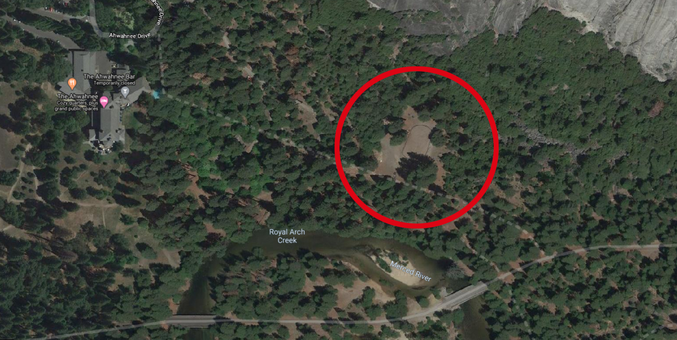
With regards to Camp 8, does anyone know what the oval is in the image below? It is right about where the old camp would have been?

Re: Pre-1970's Yosemite Campground Numbers
August 05, 2020 02:18PM
Quote
shastacatfish
Here is what I have been able to piece together thus far:


A lot of these are well known. However, Camps 20 and 8 are somewhat mysterious to me and I can only reckon their existence from maps and no more. Camp 10 near Mirror Lake was identified via Schaffer's book (great tip, thank you!) but has appeared on no maps I have found thus far. Interestingly Camps 6,9 and 17 have had longer lives than one might expect. Camp 9 is now the backpacker's camp. Camp 6 is in the area now occupied by the new day-use parking. When I was a kid, we always camped at housekeeping (Camp 16), usually near the bend in the river. I remember seeing white canvas tents through the brush across the river. That was employee housing that morphed out of old Camp 6. The fate of Camp 17 is even more interesting. Originally known as Housekeeping and was located immediately east of the auto garage just across the road from the village store parking lot. All the houses along the paved path on the west side of Ahwahnee Meadow, as well as the employee housing behind them are all remnants of the old camp. The garage building is at least 103 years old and almost certainly older.

Still no record of camps 1,2,3, 5, or 13, though, as pointed out, 13 may not have existed.

With regards to Camp 8, does anyone know what the oval is in the image below? It is right about where the old camp would have been?


Pretty sure that is the Ranger's horse training ring. Have seen Rangers on horses gathering in that area over the years.

avatar Re: Pre-1970's Yosemite Campground Numbers
August 05, 2020 04:07PM
Quote
mtn man
Pretty sure that is the Ranger's horse training ring. Have seen Rangers on horses gathering in that area over the years.

That is interesting. I had no idea about that, though I have been by there several times. Aren't there ranger's stables over by the administrative center? It seems odd to have to ride or haul horses all the way over there. Perhaps it was something of a halfway point between the old public stables and the ones at admin. It's pretty close to where old Camp 8 was. I wonder if it might have been an equestrian camp.
Re: Pre-1970's Yosemite Campground Numbers
August 06, 2020 08:03AM
Don't know, but I've seen them form up there for one of their full dress color guards or parades. I don't remember any stables there.

https://yosemitepark.files.wordpress.com/2013/06/nps_mounted_color_patrol.jpg


Edited 1 time(s). Last edit at 08/06/2020 08:11AM by mtn man.
Re: Pre-1970's Yosemite Campground Numbers
August 06, 2020 08:07AM
Quote
mtn man
Don't know, but I've seen them form up there for one of their full dress color guards or parades. I don't remember any stables there.

https://yosemitepark.files.wordpress.com/2013/06/nps_mounted_color_patrol.jpg

https://yosemite.org/projects/keep-horses-at-the-heart-of-yosemite-2019/


Edited 1 time(s). Last edit at 08/06/2020 08:11AM by mtn man.
avatar Re: Pre-1970's Yosemite Campground Numbers
August 09, 2020 07:42PM
I hit the jackpot with Linda Wedel Greene's exhaustive documentation of park infrastructure. What a resource!

Here is what it looked like:
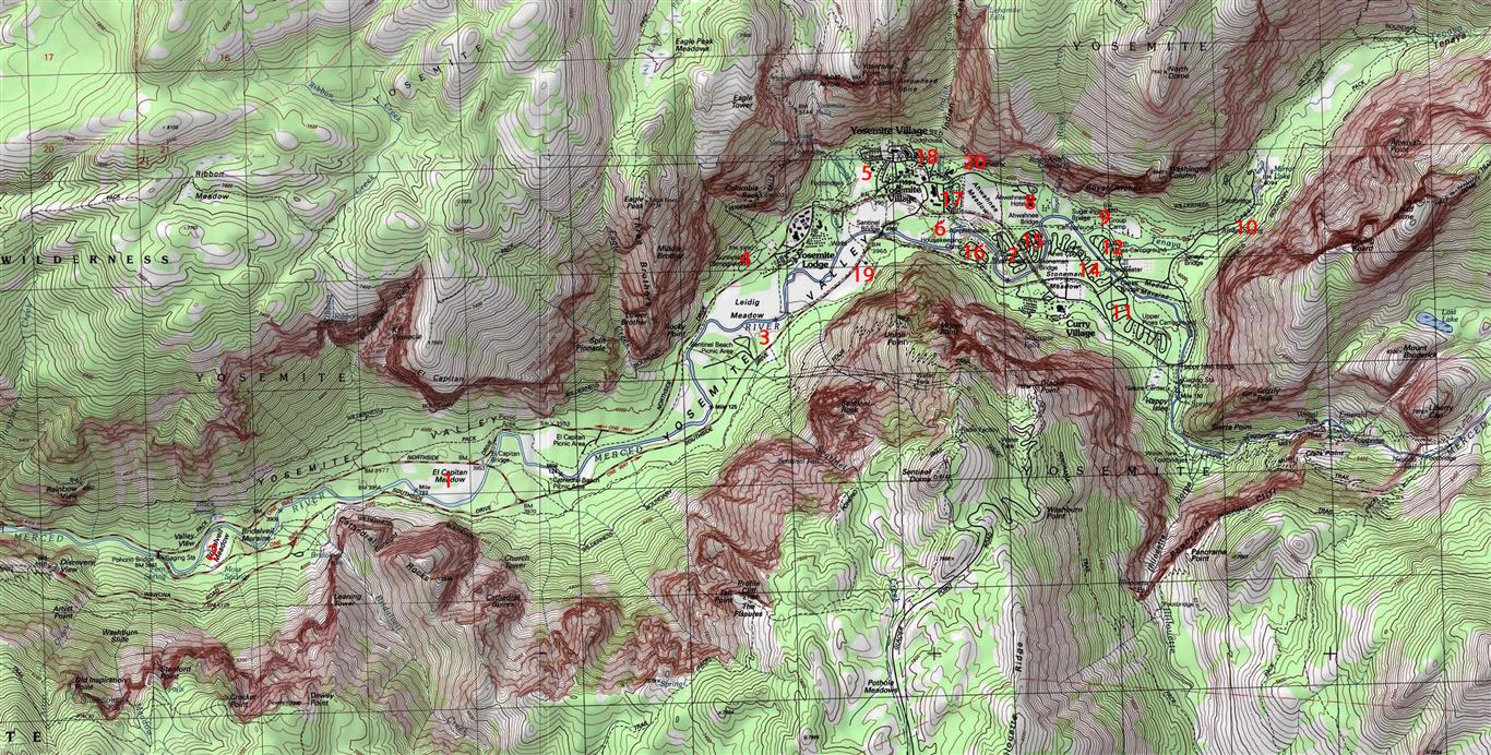


From Greene's description:

Camp No. 1 - EI Capitan Meadow. Early campers needed meadows for
pasturing their horses and mules. Abandoned for sanitary reasons
soon after 1906.

Camp No. 2 - Bridalveil Meadow. Used almost exclusively by army
troops when in the valley between 1890 and 1906. Abandoned for
sanitary reasons soon after 1906.

Camp No. 3 - west of Yosemite Village on the south side of the
Merced River in the trees at the west end of the meadow near Galen
Clark's house. Abandoned for sanitary reasons soon after 1906.

Camp No. 4 - Leidig Meadow, including portion of present Yosemite
Lodge grounds. Retired from public use upon establishment of army
headquarters in the valley. Abandoned for sanitary reasons also
soon after 1906.

Camp No. 5 - east of Yosemite Creek bridge, extending as far as the
apple orchard and Hutchings's cabin, including the area later
occupied by the park supervisor's home. Abandoned for sanitary
reasons soon after 1906.

Camp No. 6 - very old site. Later used by government and Yosemite
Park and Curry Company employees. Located south of present park
headquarters on north side of the Merced River.

Camp No. 7 - still in original location along Merced River north of
Camp Curry. Eventually divided by new road, creating two separate
camps. East portion became No. 15.

Camp No. 8 - located above Royal Arch Creek and included present
Ahwahnee Hotel grounds. Erection of the hotel in 1926 forced its
abandonment.

Camp No. 9 - old site on Tenaya Creek adjacent to and including
Royal Arch Meadow. Known as the "Organization Camp."

Camp No. 10 - near Iron Spring on Tenaya Creek, south of the old
Mirror Lake Road. Contained only limited space, and camping was
discouraged as demand for space in the area grew. Abandoned with
change of road alignment to Mirror Lake in the administration of
Superintendent Washington B. Lewis.

Camp No. 11 - originally intended to include the area now occupied
by the Curry Company stables and extending eastward, but that
area never functioned as a public campground. Number 11 was then
assigned to its present site south of Camp 14 on the road to Happy
Isles.

Camp No. 12 - located across the Merced River from Camp No. 14,
near Yosemite Park and Curry Company stables.

Camp No. 13 - never existed for reasons of superstition.

Camp No. 14 - still in original location, northeast of Camp Curry.

Camp No. 15 - one-half of original Camp No. 7.

Camp No. 16 - originally open to auto camping, but then reserved for
visitors desiring rental equipment and housekeeping facilities.
Northwest of Camp Curry on south side of Merced River.

Camp No. 17 - known at one time as "Camp Tecoya," later utilized for
permanent residences of employees of Yosemite Park and Curry
Company. (Now commonly referred to as Lower Tecoya)

Camp No. 18 - later occupied by post office and photographic studios
in New Village.

Camp No. 19 - formerly a public campground, then used exclusively
by government employees. Located about 600 feet southwest of
Sentinel Bridge. Beginning in 1912, the gradual segregation of
employees and park visitors in campgrounds began.

Camp No. 20 - now occupied by the Church Bowl.

This raises a few more questions but it answers a lot of other ones. For example, it makes sense why Roosevelt and Muir camped where they did in 1903, since Bridalveil Meadow was the main site for the army's encampment in the valley.

Also, a lot of the park's current infrastructure has roots back in the old campgrounds. The Yellow Pine / Muir Tree Campground from the 70's was not at the site of Camp 3, but pretty close.


Edited 1 time(s). Last edit at 08/09/2020 07:45PM by shastacatfish.
Re: Pre-1970's Yosemite Campground Numbers
August 13, 2020 01:48PM
thanks for posting this! Great stuff!
Sorry, only registered users may post in this forum.

Click here to login