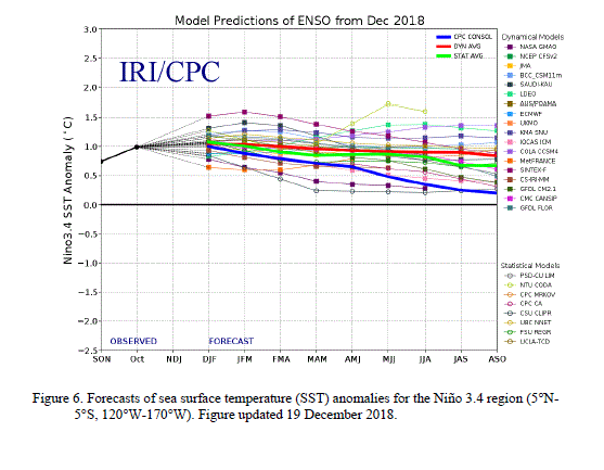
The current ENSO model forecasts have not changed significantly compared to last month (Fig. 6). La Niña is currently near its peak and is expected to persist into the Northern Hemisphere spring 2011 at a lesser intensity. Thereafter, there remains considerable uncertainty as to whether La Niña will last into the Northern Hemisphere summer (as suggested by the NCEP CFS and a few other models), or whether there will be a transition to ENSO-neutral conditions (as suggested by the CPC CON and a majority of the other models).
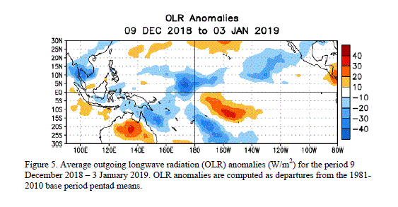
Likely La Niña impacts during January-March 2011 include suppressed convection over the west-central tropical Pacific Ocean, and enhanced convection over Indonesia. Impacts in the United States include an enhanced chance of above-average precipitation in the Pacific Northwest, Northern Rockies (along with a concomitant increase in snowfall), Great Lakes, and Ohio Valley. Below-average precipitation is favored across the southwestern and southeastern states. An increased chance of below-average temperatures is predicted for much of the West Coast and northern tier of states (excluding New England), and a higher possibility of above-average temperatures is forecast for much of the southern and central U.S. (see 3-month seasonal outlook released on December 16th, 2010). While seasonal temperature and precipitation patterns in the U.S. are strongly influenced by La Niña, these signals can be modified by other factors, such as the Arctic Oscillation (AO)/ North Atlantic Oscillation (NAO).
