Welcome! Log In Create A New Profile Recent Posts
Vernel Fall, Merced River, Yosemite National Park

The Moon is Waning Crescent (19% of Full)

JanSport - Accept no Imitations. The Original Backpack since 1967.


Advanced

Fire Creeping in Hawai`i Volcanoes

All posts are those of the individual authors and the owner of this site does not endorse them. Content should be considered opinion and not fact until verified independently.

avatar Current Eruption Captivates
March 08, 2011 11:17AM

Jay Robinson
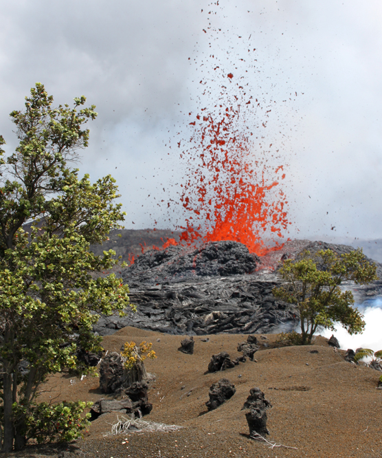
Lava spatters from a new fissure that broke open in a field of tephra.


The eruption that began on March 5, 2011, continues on the east rift of Kilauea Volcano.

Lava spatters sporadically to average heights of 65' from a series of fissues that extend more than a mile between Napau Crater and Pu`u `O`o. Aound the vents, molten rock puddles and hardens.

In response to the change in volcanic conditions, nearly thirty park personnel have rallied to support this major incident, meeting and planning for the first time in the park's new Visitor Emergency Operations Center.

Rangers remain vigilant. Seismicity is ongoing, the volcano's summit continues to deflate, and magma migrates underground beneath roads, trails, and a campsite on the volcanoe's east rift.

Hawai`i Volanoes closed Chain of Craters Road and all east rift and coastal trails, along with Kulanaokuaiki Campground, until further notice. The closure helps ensure that hikers and cars don't get trapped on the 'wrong side' of an outbreak.

USGS Hawaiian Volcano Observatory scientists seize this oportunity to measure gas emissions and surface deformation, collect lava and fallout, and map the ever-changing landscape.

Park firefighters gauge the threat of lava-ignited wildfires. Fortunately for now, drenching rains offer a reprieve from potential flare-ups in the surrounding native `ohi`a-hapu`u rain forest.

Public and media interest is keen and visitation is up. The park and its most popular overlooks and summit trails remain open. However, because the new eruption is remote and inaccessible, rangers share the latest information, photos, and videos at Kilauea Visitor Center and Jaggar Museum. A webcam view is available on-line at http://volcanoes.usgs.gov/hvo/cams/NCcam/

It's a phenomenal time, and for some, deja vu. The volcanic event is located where it all vegan twenty-eight years ago. On January 3, 1983, Kilauea's ongoing east rift eruption oprned in this very spot. Newcomers can't help but wonder "What happens next?" Old-timers take time to pause and ponder, and offer an occasional "I remember when... "

Re: Current Eruption Captivates
March 08, 2011 11:20AM
The only thing from an undergrad geology class that really stuck for me was "pahoehoe." For some reason the volcanoes in Hawai'i fascinate me.

Going looking at the webcam. Awesome. Thanks.
avatar Re: Current Eruption Captivates
March 08, 2011 11:37AM
Re: Current Eruption Captivates
March 09, 2011 09:07PM
If you look at night you can see it glowing in the dark! cool.
avatar Re: Current Eruption Captivates
March 08, 2011 05:52PM
Quote
eeek

Jay Robinson
Lava spatters from a new fissure that broke open in a field of tephra.


That is a very unusual photo.


The cure for a fallacious argument is a better argument, not the suppression of ideas.
-- Carl Sagan
avatar Re: Current Eruption Captivates
March 09, 2011 09:20PM
The eruption on Kīlauea volcano's east rift zone continued throughout the day at the western end of the 2.3 km (1.4 mi) long Kamoamoa fissure located between Pu'u 'Ō'ō and Nāpau Crater. Lava spatter erupted from the active fissure reached as high as 50 m (160 ft), but more typically reached heights of 30-40 m (100-130 ft).

Lava erupted from the western end of the fissure, which is near the eastern rim of Nāpau Crater, has formed a channelized 'a'ā flow that extends 2.9 km (1.8 mi) to the southwest. The lava flow ranges from 80 to 290 m (260 to 950 ft) wide, but the active channel within the flow is only about 20 m (65 ft) wide.

HVO scientists installed a new Webcam-Kamoamoa Eruption, West Fissure-this afternoon. These Webcam images of the western end of the fissure can be accessed at http://volcanoes.usgs.gov/hvo/cams/.

Gas measurements today show an SO2 emission rate of about 4,400 tonnes/day, significantly lower than the 10,000 tonnes/day emission rates measured on March 6-8, but still elevated above the 300 tonnes/day measured during the past several months (prior to March 5).

Pu'u 'Ō'ō and the TEB vent downrift (ENE) of Pu'u 'Ō'ō remain inactive today.

Summit SO2 emissions today were around 500 tonnes/day.

Seismic tremor has declined, but remains elevated above pre-Kamoamoa eruption levels at both Kīlauea's summit and east rift zone.

Deflation continues to slow at both the summit and east rift zone.

At Kīlauea's summit, the lava lake within the Halema'uma'u Crater vent is estimated to be about 220 m below the crater floor based on visual observations this morning.
avatar Re: Current Eruption Captivates
March 10, 2011 03:56PM
Hawaii Volcanoes National Park (HI)
Kamoamoa Eruption Continues

The eruption on Kilauea, now being referred to as the Kamoamoa Eruption, is continuing with considerable intensity, causing lava spatters to heights of 200 feet. Fissures are feeding a lava flow that extends nearly two miles from its source; near the fissure, the flow is hot, ropy pahoehoe, but at its terminus, the flow turns to a clinkery jumble of ‘a‘a. The flow volume is calculated at 2.5 million cubic meters per day, five times more than Kilauea has been putting out from the east rift during the past several years. Lava flows have covered 162 acres of park land. East rift zone sulfur dioxide gas emissions are at 10,000 tonnes per day, significantly elevated above the 300 tonnes per day measured during the past several months and as recently as March 5th, prior to the fissure eruption. Lava-ignited wildfires have burned 78 acres of rain forest. The forest downwind of the fissures is choked by volcanic fumes; dieback of some ferns, shrubs, and trees is certain. Meanwhile, the park continues to enforce closures and operate under ICS .
avatar Re: Current Eruption Captivates
March 10, 2011 07:47PM
The Kamoamoa fissure eruption on Kīlauea Volcano's east rift zone has paused. Based on Webcam images, lava stopped erupting from the western end of the fissure late last night. Direct observations by HVO scientists in the field today confirmed that no lava was erupting from either end of the fissure.

East rift zone SO2 emissions continue to decline. Summit SO2 emissions today were around 500 tonnes/day.

Seismic tremor was declining, but remained elevated above pre-Kamoamoa eruption levels at Kīlauea's summit and the Kamoamoa eruption site.

Overnight, the summit inflated, but at noon today, tilt showed deflation similar to that observed during DI events. On the east rift zone, deflation continues.

At Kīlauea's summit, the lava lake within the Halema'uma'u Crater vent was not visible this morning, most likely a result of being obscured by rubble.
avatar Kilauea Daily Update issued Mar 11, 2011 07:02 HST
March 11, 2011 01:13PM
Activity Summary for past 24 hours: There was no active lava visible on Kilauea volcano. On the east rift zone, the March 5 Kamoamoa fissure eruption was still paused. At the summit, the bottom of the deep vent inset within the east wall of Halema`uma`u Crater was covered with rubble and lava was no longer visible. Summit seismicity and sulfur dioxide emissions remained elevated.

Past 24 hours at Kilauea summit: The bottom of the deep vent inset within the east wall of Halema`uma`u Crater was covered with rubble when viewed from the air yesterday. The summit tiltmeter network recorded DI-like deflation starting at noon yesterday. Seismic tremor levels increased slightly.

Thirty-three earthquakes were strong enough to be located within Kilauea volcano - one within the upper east rift zone and thirty-two in a northwest-southeast alignment beneath Kalapana, including a magnitude-4.6 quake before midnight last night.

The summit gas plume is moving to the southwest this morning. The most recent (preliminary) sulfur dioxide emission rate measurement was 800 tonnes/day on March 10, 2011.

Past 24 hours at the middle east rift zone vents: The fissure eruption that started March 5 within Hawai`i Volcanoes National Park remained paused.

The most recent (preliminary) sulfur dioxide emission rate measurement was 350 tonnes/day on March 10, 2011 from all east rift zone sources. substantially lower than earlier in the week.

The tiltmeter on the north flank of Pu`u `O`o recorded continuing deflation. Seismic tremor levels have decreased to moderate values around Pu`u `O`o Crater.

Hawai`i Volcanoes National Park message: In response to the current volcanic conditions, Hawai'i Volcanoes National Park has closed some areas of the park. Check the latest information at http://www.nps.gov/havo/closed_areas.htm.

Hazard Summary: East rift vents and flow field - near-vent areas could erupt or collapse without warning; potentially-lethal concentrations of sulfur dioxide gas are present within 1 km downwind of vent areas. Kilauea Crater - explosive events are capable of ejecting rocks and lava several hundred meters (yards) from the Halema`uma`u vent; ash and potentially-lethal concentrations of sulfur dioxide are present within 1 km downwind.
avatar Section Of Chain Of Craters Road Reopened
March 14, 2011 02:12PM
Hawaii Volcanoes National Park (HI)
Section Of Chain Of Craters Road Reopened

A six mile section of Chain of Craters Road, closed due to the recent eruption on Kilauea, has reopened, as trade winds have helped reduce sulfur dioxide emissions.
avatar Fire Creeping in Hawai`i Volcanoes
March 16, 2011 01:05PM
Fire Creeping in Hawai`i Volcanoes
Date: March 14, 2011
Contact: Mardie Lane, 808-985-6018

There is currently no lava activity on Kilauea Volcano's east rift. However, a lava flow from the Kamoamoa Eruption has sparked a slow-moving wildfire. Park firefighters report that at least 75 acres have burned during the past 24-hours. The lava-ignited fire is creeping through ohia forest, fueled by uluhe fern. It's burning in an area that has burned on at least two previous occasions due to lava flows. In preparation, firefighters set up large dipping ponds at two locations on Chain of Craters Road in the event water bucket drops are needed tomorrow. They'll fly over the area Tuesday morning to assess the fire threat situation and determine what response, if any, to take.

This afternoon, two webcams set out by the USGS Hawaiian Volcano Observatory captured images of the smoke rising from the burn area. The webcam images can be viewed at http://volcanoes.usgs.gov/hvo/cams/NCcam/ and http://volcanoes.usgs.gov/hvo/cams/KWcam/
Sorry, only registered users may post in this forum.

Click here to login