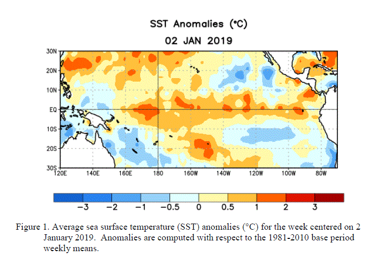
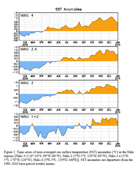
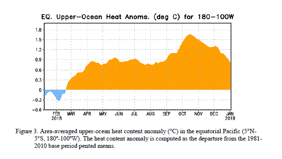
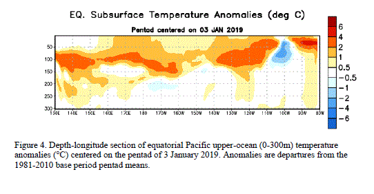
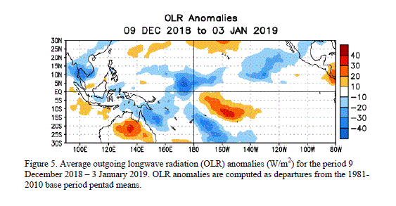
La Niña conditions returned in August 2011 due to the strengthening of negative sea surface temperature (SST) anomalies across the eastern half of the equatorial Pacific Ocean (Fig. 1). With the exception of the far westernmost Niño-4 region, all of the latest weekly Niño index values were –0.5oC or less (Fig. 2). Also supporting the return of La Niña conditions was the strengthening of the below-average subsurface oceanic heat content anomaly (average temperature anomalies in the upper 300m of the ocean, Fig. 3), in response to increased upwelling and further shoaling of the thermocline across the eastern Pacific Ocean (Fig. 4). The atmospheric circulation over the tropical Pacific continued to exhibit La Niña characteristics, but remained weaker and less canonical than the wintertime atmospheric patterns. For example, convection continued to be suppressed near the Date Line, but remained south of the equator, while convection was only weakly enhanced near Papua New Guinea (Fig. 5). In addition, anomalous low-level easterly and upper-level westerly winds persisted over the central tropical Pacific. Collectively, these oceanic and atmospheric patterns reflect the return of La Niña conditions.
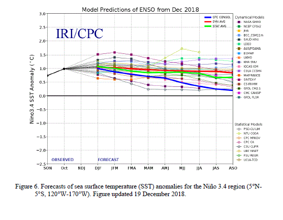
Over the last several months many models have predicted increasingly negative SST anomalies in the Nino-3.4 region during the upcoming Northern Hemisphere fall and winter. However, the majority of models continue to predict ENSO-neutral conditions for this period (Fig. 6). The NCEP Climate Forecast System (CFS) has performed quite well over the past several months (Fig. 7) capturing the recent decrease in SST anomalies. The better model performance, combined with the historical tendency for significant La Niña episodes (as in 2010-11) to be followed by relatively weaker La Niña episodes, leads to increased confidence that La Niña will persist into the winter. While it is not yet clear what the ultimate strength of this La Niña will be, La Niña conditions have returned and are expected to gradually strengthen and continue into the Northern Hemisphere winter 2011-12.
Across the contiguous United States, temperature and precipitation impacts associated with La Niña are expected to remain weak during the remainder of the Northern Hemisphere summer and early fall, and to generally strengthen during the late fall and winter. During September-November 2011, there is evidence that La Niña favors an increased chance of above-average temperatures across the mid-section of the country, and an increased chance of above-average precipitation across the Pacific Northwest (see 3-month seasonal outlook released on 18 August 2011).
This discussion is a consolidated effort of the National Oceanic and Atmospheric Administration (NOAA), NOAA's National Weather Service, and their funded institutions. Oceanic and atmospheric conditions are updated weekly on the Climate Prediction Center web site (El Niño/La Niña Current Conditions and Expert Discussions). Forecasts for the evolution of El Niño/La Niña are updated monthly in the Forecast Forum section of CPC's Climate Diagnostics Bulletin. The next ENSO Diagnostics Discussion is scheduled for 6 October 2011. To receive an e-mail notification when the monthly ENSO Diagnostic Discussions are released, please send an e-mail message to: ncep.list.enso-update@noaa.gov.
