
The Moon is Waxing Gibbous (78% of Full)
Home
>
General Discussion
>
Topic
Re: Tioga Road Opening and Closing Dates
All posts are those of the individual authors and the owner
of this site does not endorse them. Content should be considered opinion
and not fact until verified independently.
|
Trail on west of Tuolume River to Glen Aulin April 08, 2009 07:44PM | Registered: 16 years ago Posts: 30 |
Planning a trip to Waterwheel Falls in early July (yes, mosquitoes!). Is it safe to take fairly unused trail from Pothole Dome towards Glen Aulin on west side of river at that time? Wondering if too much water to be safe. Have done usual trail on east side, but want to get there faster. Thanks!
April 08, 2009 07:50PM | Admin Registered: 16 years ago Posts: 17,140 |
April 13, 2009 09:34PM | Admin Registered: 16 years ago Posts: 17,140 |
April 13, 2009 11:13PM | Registered: 16 years ago Posts: 1,347 |
I will be doing this exact same hike (my maps are printed and ready to go!) the first week of access to Tuolumne ( beginning of May, so says the ranger that the road will be open...we shall see) I will report back as to my findings....(or I will call on my cell phone for a boat taxi ride up the river if there is too much water)
B
B
April 14, 2009 06:49AM | Registered: 16 years ago Posts: 1,882 |
April 14, 2009 08:32AM | Registered: 16 years ago Posts: 1,347 |
April 14, 2009 10:28AM | Registered: 16 years ago Posts: 196 |
April 14, 2009 05:31PM | Registered: 16 years ago Posts: 1,876 |
Quote
tomdisco
Bee,
I think the ranger is being a bit optimistic. Rick may repost recent history of Tioga Road openings. Early May seems like a long shot unless we get a quick snow melt and no late storms.
Jim
Just a bit. Anyone recall a previous thread about starting the Tioga Road plowing on 15 April (seemingly irregardless of actual weather/snow conditions)?
Link to Tioga Road Opening/Closing dates:
http://www.monobasinresearch.org/data/tiogapass.htm
April 14, 2009 05:39PM | Registered: 16 years ago Posts: 1,347 |
Quote
szalkowski
Quote
tomdisco
Bee,
I think the ranger is being a bit optimistic. Rick may repost recent history of Tioga Road openings. Early May seems like a long shot unless we get a quick snow melt and no late storms.
Jim
Just a bit. Anyone recall a previous thread about starting the Tioga Road plowing on 15 April (seemingly irregardless of actual weather/snow conditions)?
Link to Tioga Road Opening/Closing dates:
http://www.monobasinresearch.org/data/tiogapass.htm
I am absolutely certain at this point that I processed the information wrong, mixed it all up, misunderstood the dates (I had a whole list of things I was asking about) in other words: had a business as usual day.
B
Edited 1 time(s). Last edit at 04/14/2009 05:45PM by Bee.
April 14, 2009 06:12PM | Registered: 16 years ago Posts: 1,882 |
Sometime in the last 10 months eeek posted a few years worth of Tioga Road opening dates. I believe last year was 5/31, most were in June, and one in July. I tried searching for that thread but it apparently got posted within some other thread.
eeek, can you help us out? I know you have that info at your fingertips.
Jim
eeek, can you help us out? I know you have that info at your fingertips.
Jim
April 14, 2009 06:38PM | Admin Registered: 16 years ago Posts: 17,140 |
Tioga Road opening and closing dates since 1980:
1980 June 6 Dec 2
1981 May 15 Nov 12
1982 May 28 Nov 15
1983 June 29 Nov 11
1984 May 19 Nov 8
1985 May 8 Nov 12
1986 May 24 Nov 29
1987 May 2 Nov 13
1988 Apr 29 Nov 14
1989 May 12 Nov 24
1990 May 17 Nov 19
1991 May 26 Nov 14
1992 May 15 Nov 10
1993 June 3 Nov 24
1994 May 25 Nov 10
1995 June 30 Dec 11
1996 May 31 Nov 5
1997 June 13 Nov 12
1998 July 1 Nov 12
1999 May 28 Nov 23
2000 May 18 Nov 9
2001 May 12 Nov 11
2002 May 22 Nov 5
2003 May 31 Oct 31
2004 May 14 Oct 17
2005 June 24 Nov 25
2006 June 17 Nov 27
2007 May 11 Dec 6
2008 May 21 Oct 30
~
April 14, 2009 06:41PM | Admin Registered: 16 years ago Posts: 17,140 |
April 15, 2009 06:56AM | Registered: 16 years ago Posts: 1,882 |
April 15, 2009 09:03AM | Registered: 16 years ago Posts: 1,942 |
Check out the dates in 1976 and number of days the road was open that year!Quote
tomdisco
eeek,
Wow! The Tioga opening dates are really all over the place, including quite a few early and mid-May. Thank you for the posting.
Jim
The cure for a fallacious argument is a better argument, not the suppression of ideas.
-- Carl Sagan
April 15, 2009 09:15AM | Registered: 16 years ago Posts: 1,347 |
Quote
tomdisco
eeek,
Wow! The Tioga opening dates are really all over the place, including quite a few early and mid-May. Thank you for the posting.
Jim
(Jim, your Avatar is REALLY scary!) It would be interesting to see what the snowfall data was for the early May dates. They definitely would have to be years in which the snowfall ended early.
B
April 15, 2009 11:03AM | Registered: 16 years ago Posts: 1,882 |
Bee,
Yes, I'm wondering about an earlier opening this year also, mostly because total snowfall to date appears to be down a bit from last year.
The avatar displays Smeagle's dark, scheming, vengefull personality. His other side was mostly pathetic bewilderment and fear. Someday I'll switch it out for a nice western wildlife scene but since I'm still in the dog house this one is more appropriate.
Jim
April 15, 2009 11:35AM | Registered: 16 years ago Posts: 1,876 |
April 15, 2009 11:58AM | Registered: 16 years ago Posts: 1,347 |

|
Re: Trail on west of Tuolume River to Glen Aulin April 14, 2009 10:12AM | Registered: 16 years ago Posts: 106 |
April 14, 2009 10:20AM | Registered: 16 years ago Posts: 1,347 |

April 15, 2009 10:27AM | Registered: 16 years ago Posts: 145 |
Quote
YAY
Planning a trip to Waterwheel Falls in early July (yes, mosquitoes!). Is it safe to take fairly unused trail from Pothole Dome towards Glen Aulin on west side of river at that time? Wondering if too much water to be safe. Have done usual trail on east side, but want to get there faster. Thanks!
I hiked that West side of the river from Glen Aulin to Pothole Dome in mid-July 2005, and it's truly beautiful. No problem finding the trail, and I wouldn't expect high water problems in May or June, though there'd probably be some snow on the ground. Mosquitos there the second week of July '05 were the worst part of the trip.
|
Re: Trail on west of Tuolume River to Glen Aulin April 15, 2009 07:25PM | Registered: 16 years ago Posts: 30 |
April 22, 2009 02:33PM | Admin Registered: 16 years ago Posts: 17,140 |
April 22, 2009 07:33PM | Registered: 16 years ago Posts: 1,347 |
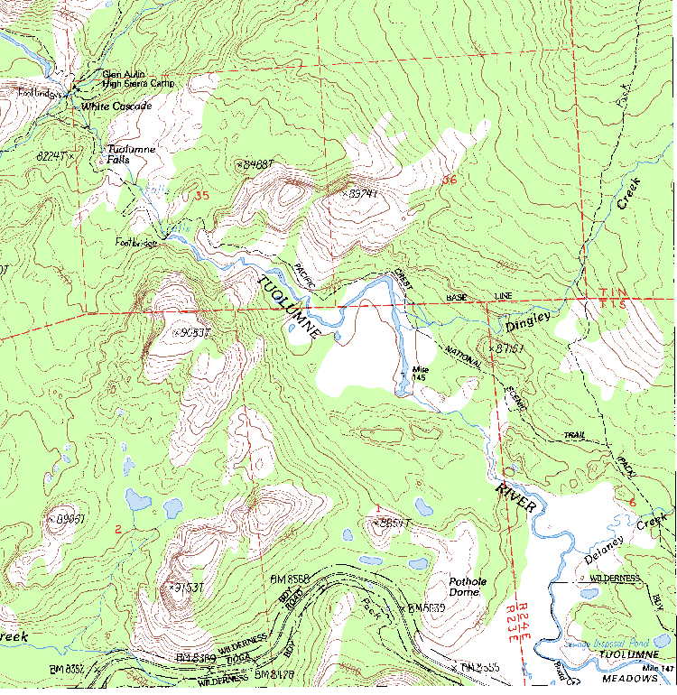
This is great. I have been producing different maps (to different success) by downloading Topo that came with the GPS that I never use. The first couple of tries did not print out very well because I had my printer set on "draft" (hey, all that Tax crud uses a LOT of ink) after changing the setting, the elevation lines showed up much better. BTW, is there an actual light "trail" that passes thru the pothole dome area to the west side of the river, or is it pretty much make it up as you go?
B
B
April 22, 2009 08:08PM | Registered: 16 years ago Posts: 2,321 |
April 22, 2009 08:25PM | Admin Registered: 16 years ago Posts: 17,140 |
April 22, 2009 10:57PM | Registered: 16 years ago Posts: 1,347 |
Quote
eeek
Quote
BTW, is there an actual light "trail" that passes thru the pothole dome area to the west side of the river, or is it pretty much make it up as you go?
There are several use trails. This one actually goes on the log:
(how would he know to take a picture of that log and make it relevant?!)
B
April 22, 2009 11:01PM | Admin Registered: 16 years ago Posts: 17,140 |
April 22, 2009 11:14PM | Registered: 16 years ago Posts: 1,347 |
Quote
eeek
Quote
Bee
(how would he know to take a picture of that log and make it relevant?!)
Hey! At least I wasn't crazy enough to do it on 4x5 (though I was crazy enough to hall that camera on that trail).
Oh, I cannot (unfortunately) tease about the amount of equipment one totes on a hike. My photo buddy and I used to talk his wife into just-one-more-hike-that-I-promise-wont-be-all-about-picture-taking, so that we would have an extra body to carry all the extra equipment!
B
April 22, 2009 11:17PM | Admin Registered: 16 years ago Posts: 17,140 |
Quote
Bee
Quote
eeek
Quote
Bee
(how would he know to take a picture of that log and make it relevant?!)
Hey! At least I wasn't crazy enough to do it on 4x5 (though I was crazy enough to hall that camera on that trail).
Oh, I cannot (unfortunately) tease about the amount of equipment one totes on a hike. My photo buddy and I used to talk his wife into just-one-more-hike-that-I-promise-wont-be-all-about-picture-taking, so that we would have an extra body to carry all the extra equipment!
B
I have to admit I have used a friend to tote heavy camera equipment. But I'm also responsible for getting him addicted to hiking in the first place.
Sorry, only registered users may post in this forum.

