I'm going to make up names for some features that don't already have them. These names will always appear in "quotes", unless they are standard systematic names like 'Lake 9637'.
Overview
Route
We had a permit for 5 nights, entering at Nelson Lake. The plan was to cross-country to Emeric Lake, loop down Fletcher Creek and up Lewis Creek, then hook east from Vogelsang and descend Lyell Canyon.
Here is the planning thread where the cross-country section was discussed.
Entering at the Elizabeth Lake trailhead, we passed the lake, crossed the pass, and began descending Echo Creek, but didn't quite make it to Nelson on the first day. On the second day, we passed Nelson Lake, turned south until reaching the lower slopes of the big ridge, followed them southwest, and turned due south to camp at Lake 9637. However, on the morning of the third day we found the descent to Emeric Lake rather difficult, so we retraced our steps to Nelson Lake, and spent the third night at Reymann Lake. We then scaled the pass to the east, descended the creek on the other side, and caught the Rafferty Creek trail. From Tuolumne Pass, we left the trail again and headed straight for Townsley Lake for the fourth night. We then headed north across the plateau, arced northeastward, and regained the trail at the low pass east of Evelyn Lake. Staying on trail for the remainder of the trip, we continued into Lyell Canyon and made our fifth and last camp a little south of the trail junction, though we dayhiked some way farther south later in the afternoon. Finally, we followed the JMT back to the trailhead.
Here is the actual route.
Conditions
Rain threatened us nearly the entire time. There was always significant cloud cover by noon, rushing us to make camp quickly. Some rain fell each day, but contrary to expectation, it was usually light. Daytime temperatures were in the 60s, but overnight lows were moderate -- the only morning below 40 degrees was the last one, in Lyell Canyon (oddly, our lowest campsite).
Mosquitoes were a moderate nuisance at Reymann Lake, and only a slight nuisance elsewhere. Some other parties reported bad mosquitoes at Ten Lakes and Evelyn Lake.
Recommendations
This is a trip for lovers of trailless hiking who know their way with a compass. I would recommend a shorter loop, with at least a first night at Echo Creek or Nelson Lake and a second night at Townsley Lake. Inveterate seekers of solitude will find Lake 9637 a worthy destination for a dayhike from Nelson Lake, despite the lack of views along the first stretch of the route. Exploring down Echo Creek also looks quite attractive, although @rgliebe points out that below a certain point the southeast side of the canyon becomes difficult to ascend or descend. An extra night could also be added east of Reymann Lake to give extra time to explore this area. The side trip to Lyell Canyon has much to like and much to dislike; details below.
Details
Day 1
We got a late start around noon on Friday, August 18. One reason for the delay was that even though we already had our permit, we stopped at the Tuolumne permit station and asked if anyone had done our route. The rangers hadn't.
The Elizabeth Lake trailhead is inside the (huge) Tuolumne Meadows campground, but there are signs much of the way from the campground entrance. The trailhead has bear boxes, flush toilets, and a water spigot. Parking was ample.
After an ascent of maybe a mile and a half through unimpressive pine forest, the land began to open up into meadows, with scattered boulders and young trees. There was a fair number of dayhikers, but the trail wasn't crowded like, say, the Glen Aulin trail. In a level area, we came to an unsigned junction. One branch followed the creek to the right (west), the other continued straight (south). Somewhat confused, we took the right branch, and after a creek crossing (unmapped) quickly found ourselves at the north lobe of Elizabeth Lake. This is a fine subalpine lake, and it would be overrun by campers if camping were allowed. We later figured out that the left branch of the trail bypasses the lake and heads straight for the pass ("Elizabeth Pass"
 , but in spite of the more challenging destination it is surprisingly well-worn.
Recrossing the creek, we followed the continuing use trail through woods to the south lobe of Elizabeth Lake, and it shortly began to climb. We followed it with little difficulty until near the top, where we lost it. There was some snow here, stained pink with algae. We met a couple of sturdy young dayhikers, our last human encounter of the day. "Elizabeth Pass" is actually two passes, at roughly equal elevation, separated by a couple of large granite knobs. We had been advised to head for the more northerly one, but on reaching the summit we found to our consternation that we were at the more southerly pass. However, it was now after 3 pm and we decided to press on instead of trying to circle around. This was a good choice, as the descent was not bad at all. We recovered the trail, and after passing through a short stretch of sand and rocks entered a long belt of meadows draped along Echo Creek. This lovely walk passed rather quickly. Once we came abreast of the end of the ridge to the east, the trail finally turned away from the creek and we started to have difficulty following it. We had just entered the wooded hollow west of Nelson Lake when rain and hail started to fall. It was now 5 pm and we were tired and off the trail. Finding a trickle of a stream running through our hollow, we made a hasty camp.
Day 2
Refreshed, we walked about 100 feet from our camp and regained the trail -- only to promptly lose it again when it ran into a fallen tree. Emerging onto open granite, then re-entering forest, we reached Nelson Lake, about 20 minutes from our forced camp. The goal on this route is go to avoid climbing the small ridge northwest of the lake, but go high enough to avoid the impassable gorge of "Nelson Creek". Nelson Lake is quite beautiful, flanked by wide meadows and, behind them, granite cliffs. A party of four was base-camping on the southwest shore. The patriarch told us that he'd been coming to Nelson Lake for 30 years, and recommended that we go to Reymann Lake. Undeterred, we pumped water, crossed the outlet, and continued on our planned route around 10 am. Those people were the last we saw until late morning of Day 4 (and the last bit of use trail before the lake was almost the last trail).
Crossing "Nelson Creek", we continued along the shore for a while, among plentiful campsites, then turned due south, heading directly for a summit with a round profile (presumably Peak 10760+). The forest was open at first, a joy for the feet though not a feast for the eyes. It then developed an understory of rocks, then of shrubs, and we emerged into boggy meadows, packed with logs, surrounding a creek. Crossing the creek on logs, we maintained our heading until the ground became steep, then turned to the southwest. We maintained this heading for about a mile, though we could no longer follow landmarks and I kept my compass ready to hand. The forest here is dense and pleasantly varied. We passed through one or two "pocket meadows" and a few patches of heavy deadfall, but it was enjoyable and we had little trouble following the compass.
A little before noon, we came to a clearing in a shallow bowl, which we recognized as the base of our planned ascent. There was largely open granite to the right, with some large snow patches. We chose our path along the edge of the forest patch. The ascent turned out to be low class 2: handholds required now and again. We had nearly reached the summit after half an hour, but rain broke out and we took shelter under some spruce trees (choosing small ones to avoid lightning). Once the rain eased up, we continued onto the plateau, sparsely wooded at first, then more densely on the descent to Lake 9637.
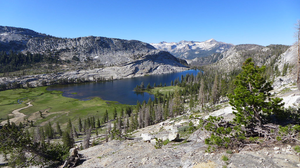
The lake is shallow but quite attractive, with a meadow on the east side. It's probably a boggy mosquito hatchery in early summer, but by the time we passed the ground had dried and the mosquitoes were gone. Just past 1 pm, we took a break for lunch. I scouted for the route onward to Emeric Lake, but didn't find it. Somewhat tired from the morning's bushwhacking and still uneasy about the possibility of more rain (which didn't come), we put off crossing the ridge to the next day. We descended the lake's outlet a short way and made camp. Climbing up to the pass overlooking Emeric Lake, I could see the whole southern rim of Yosemite, from Mount Lyell to Mount Clark, but it was nearly obscured by smoke.
Day 3
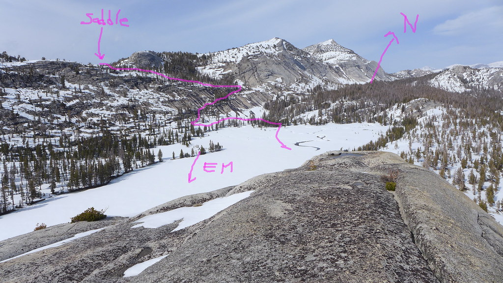
The moment of truth: I scrambled up the ridge again to survey the descent to Emeric Lake. Maybe I was looking in the wrong place, but I found the descent more difficult than I had expected. Either way, we decided not to attempt it, and instead return the way we came. We left Lake 9637 at 9 am. Rain was clearly in the cards again but not imminent, so we paused on the granite knob just west of our steep ascent the day before to take in the views. These were surprisingly quite good, most of yesterday's smoke having cleared. I realized that the large knob due south of Lake 9637 must have nearly panoramic views, despite its humble elevation of less than 10,000 feet, but that is a climb for another day.
We did a fair job of retracing our steps to the east end of Nelson Lake, arriving at 1 pm. Some places seemed to be easier and others more difficult, particularly the last creek crossing, but the overall picture is similar. Our friends from Day 2 had left, but we didn't venture to the west end of the lake to see if a new party had come.
Instead, we kept to the east side of the valley and continued into the sprawling meadow that surrounds Nelson Lake. Passing the irregularly shaped, shallow "lake" (which actually looked like a series of ponds), we turned left (west), crossed a small, unmapped stream, and reached "Nelson Creek". We followed the creek, remaining on the east side, and quickly entered a rocky, sparsely forested gorge with a faint use trail. After a steep but quite doable ascent, the terrain opened up, first into granite slabs and then into meadows signaling the nearness of Reymann Lake. The meadows were beautiful, and the granite slabs even more so, with the creek forming wide, stepped cascades. Here I saw a tiny wonder of nature: a fountain of water emerging from seemingly solid granite. It was only inches high, but hardly less remarkable for its small size.
Finally, we emerged at Reymann Lake after 2 pm, just under an hour after leaving Nelson Lake. Reymann Lake resembles a much larger version of the middle Young Lake, except that the north face of Rafferty Peak is talus from top to bottom. Rain was on its way again (or seemed to be, at least), so we made camp. There are campsites on the flat area northwest of the lake, but they're exposed, so with some difficulty we found a site in the woods above the lake to the north-northeast. As on the first day, a trickle of water flowed nearby.
Day 4
We decided that descending back to the lake shore from our high campsite was unnecessary. Instead, we traversed eastward and headed directly for "Reymann Pass". The ascent is a little steep at first, then gradual over talus-strewn meadows, then rocky near the summit. Some of the granite here was so light-colored that it looks like plaster in my photos. The ascent took under an hour. The pass itself was viewful but windy, so we bid the westward peaks a quick goodbye and started descending the broad valley to the east. This was a beautiful stretch, airy meadows interspersed with boulder piles and patches of forest, and streams everywhere. It took us just over an hour from "Reymann Pass" to reach the forest belt, roughly following the creek. We then paused to watch the eclipse for a few minutes (my companion had brought glasses). Veering to the right, away from the creek, we re-entered "civilization" (the Rafferty Creek trail) around 10:30, having left camp just after 8.
Southbound toward Vogelsang, we met someone who recommended Townsley Lake ("Upper Fletcher Lake" according to CalTopo) and the plateau to the north. We stopped for a light lunch at Tuolumne Pass, where we found a pond, shallow but pumpable. Taking the chance advice for Townsley Lake, we left the trail again and more or less made a beeline for the lake, with the summit of dark, craggy Fletcher Peak as a convenient "beacon". After leaving the pass, we did not see another person for another 24 hours. Less than an hour of easy walking brought us to the shores of the lake, around 12:30. Ominous clouds again rushed us to make camp. The southwest shore is steep talus with a heavy snowbank, practically impassable. The northeast shore is gentle and has a use trail, presumably coming from Fletcher Lake below. If you come here via the use trail, get off of it once you reach the lake, because it passes too close to the water and too far from the campsites. These are plentiful: airy, exposed ones to the north, and cozy ones sheltered behind stunted trees to the east. We chose the latter.
This was our favorite campsite of the trip. The basin of Townsley Lake is supremely beautiful. The vegetation along the lake is similar to the tundra in parts of the Alaska Range, complete with patches of low-lying willow, but with pines in place of the tundra spruce. The ridge connecting Fletcher and Parsons Peaks is craggy and imposing, with a string of cirque glaciers below the summits. The lower slopes, though, are covered with unpleasant-looking talus that bars the approaches to aptly-named Hanging Basket Lake and unnamed lakes to the southeast. West of Townsley Lake, where the outlet stream turns briefly to the southwest, we found a delightful little waterfall. Wind and light rain did come, but cleared up before nightfall.
Day 5
This was our day to get back onto the original itinerary, but we wanted to do some one last cross-country stretch across that plateau. We headed north from our camp, then turned gradually to an eastward heading. The plateau had a sort of arctic look, with the tundra-like vegetation, big snowbanks and shallow ponds (but virtually no mosquitoes). At one point we got sweeping views to the north, over yet-unseen Evelyn Lake, and west. In the vicinity of the low ridge separating Evelyn Lake from "Little Evelyn" to the east, we ran into a big snowbank that forced us into a class-2 descent. Evelyn and "Little Evelyn" are indeed similar -- shallow, surrounded by meadow, and not terribly appealing by Yosemite's high standards. Just before "Little Evelyn", we rejoined the trail for the last and conclusive time (almost), just over 2 hours out of Townsley Lake.
Heading east toward Lyell Canyon, we found the trail rather disappointing: rocky, dry and sparsely wooded, with limited views. Even from the pass when entering Lyell Canyon, the vistas weren't as good as I'd expected. Pretty soon, the trail entered the same kind of pine forest that we passed through on Day 1 below Elizabeth Lake. It continued all the way to the canyon bottom, obscuring all views except the occasional creek sighting.
Reaching the JMT and turning south, we soon crossed Ireland Creek, the trip's largest un-bridged crossing. The trail has stone steps leading in and out of the water, but a nice log is available as well. Immediately after the crossing, we got our reward as the trail entered a band of delicious meadows with tall grass flanking the broad, lazy Tuolumne River. Campsites, though, were hard to find -- legal ones, at least. There are in fact many fine campsites, but mostly illegal because too close to the river or the trail. Away from the trail, the ground quickly becomes too steep to pitch a tent. After some searching, we found a nice site up in the woods... but more about that later. We had a wonderfully relaxing time pumping water from the river below a small cascade. Having set up our tent, we stopped worrying so much about the rain (which was in fact about to begin) and went for a dayhike southward.
The dayhike was rather wet but very enjoyable. The meadows and river were always there but always changing. I haven't seen such a gentle landscape anywhere else in the Sierra. In warm and sunny weather, the river would look inviting for a swim. We waited out the worst of the rain in a little grove of trees by a rapid in the river. The gently sloped canyon wall obscures views of Mount Lyell from most of the canyon, but I'm pretty sure I spotted it from our hideout.
After our blessed seclusion, scarcely interrupted since we crossed "Elizabeth Pass" four days earlier, the JMT was a rude shock. Between JMT hikers, the occasional PCT hiker, section hikers headed to or from the Mammoth area, and "local" hikers like ourselves, the trail is crowded. On our dayhike, we met a group of five or six big guys who ended up camping right on the bank directly below us. Our stopping point to wait out the rain was right next to a campsite that had a fire ring and log benches scarcely 15 feet from the water. Hikers willing to ford the river to the trailless side can find solitude and plenty of legal campsites. This is most easily done above Ireland Creek with its abundant waters, but on the last day we saw a trail crew camping on the east bank below that point.
Day 6
The final insult came when we were breaking camp on the last day. We tried to pick up a scrap of toilet paper, only to realize that we had discovered someone's shallow cathole just steps from where our tent had been. Ugh.
This was, in theory, the only day of straightforward trail hiking. We turned back toward the trailhead, going at a good clip on the level trail, the only obstacle being recrossing Ireland Creek. As already described, the trail is crowded with backpackers. However, we never saw many dayhikers. We understood the reason when, about three miles before the first trailhead, the trail pulled away from the river and meadows and into the forest. Much of the trail here is lightly built and heavily worn, a strange contrast to the massive bridge over Rafferty Creek and the previous day's very sturdy but moderately trafficked trail from Evelyn Lake.
There appear to be not one but two trailheads in Tuolumne Meadows campground, and we took a wrong turn and nearly reached the wrong one. Instead of backtracking, we decided, weirdly, to go cross-country for the last half-mile, skirting the edge of the campground. We emerged very close to our car, having put a fitting end to this adventurous trip.
Edited 1 time(s). Last edit at 09/17/2017 06:05PM by iivvgg.

 )
)
