Welcome! Log In Create A New Profile Recent Posts
Tuolumne Meadows and Lembert Dome during a summer storm, Yosemite National Park

The Moon is Waxing Crescent (40% of Full)


Advanced

Re: Abandoned trails and off-trail hikes near Yosemite Valley

All posts are those of the individual authors and the owner of this site does not endorse them. Content should be considered opinion and not fact until verified independently.

Abandoned trails and off-trail hikes near Yosemite Valley
June 23, 2010 05:09PM
It's June in Yosemite, and the Valley is crawling with people. None of the campgrounds or cabins in the higher elevations are open yet. It's so nice to stay in the Valley, but how to avoid the crowds on the trail?

I've been doing it for years by hiking the abandoned trails, or by pleasant off-trail walks, or hiking some of the more interesting climbers' access trails. Or, in some cases, by doing ferocious bushwhacks. Following some recent requests, I sat down an made a list of the interesting ones that are in the Valley, or at least within an area bounded by Tioga Pass Road on the north and Glacier Point Road on the south.

To the north and east of the Valley there are limitless possibilities for off-trail hikes on the slickrock and in the high country. Therefore my list is limited to the stuff closer to the Valley, where wooded terrain and steep hillsides can make the route finding interesting, and where there is a lot of history to discover.

This figure shows 32 routes that meet my criteria. I've personally done almost all of them. The few that I haven't gotten around to yet, or advise against now, are in parentheses and will be explained below.

Here is my list, with some notes below following it. And asterisk * denotes an abandoned trail or road. (.) indicates I haven't done it yet, but know that the route exists or existed once. [.] indicates a route not safe now, or perhaps likely to drop rocks on a trail below you. {.} indicates a climbers access route that is normally done without ropes, but not done so any longer by a geezer like me...

1 Foresta Road, from Foresta to El Portal via Foresta Falls (* or via old trail)
2 *Old Coulterville Road from Foresta to the Cascade parking lot
3 Tamarack Campground to Foresta trail head via Devils Dance Floor
4 *Old Big Oak Flat Road, from Tamarack Campground to El Cap Meadow
5 El Cap Ridge, from White Wolf to Ribbon Meadow...my favorite
6 (Three Brothers Gully)
7 [Eagle Tower Overlook]
8 *Indian Canyon Trail
9 {North Dome Gully, climbers access to Washington Column summit}
10 Basket Dome to Snow Creek Trail
11 Rt 120 quarry to Mt Watkins and variations
12 Olmstead Pt to Pywiack Falls base pool via airplane gully
13 Tenaya Canyon traverse
14 Quarter Domes from Half Dome Trail
15 {Half Dome Death Slabs climbers access trail}
16 {Traverse along base of Half Dome Face to the Diving Board}
17 *Sierra Point Trail
18 *Anderson Spur Trail off the Mist Trail
19 Diving Board from Emerald Pool
20 Liberty Cap west side bypass gully
21 Liberty Cap summit
22 *[Ledge Trail, i.e. 1.5 mile trail, from Curry Village to Glacier Point]
23 Union Point to Sentinel Saddle via Glacier Point water works
24 Taft Chute
25 Tree Chute
26 Phantom Valley
27 Upper Cathedral Rock via climbers descent route, or lip of Bridalveil Falls via same
28 ridge-top walk from Glacier Point Road to Dewey Point along ski trail
29 *Old Inspiration Point
30 Turtle Dome to Pohono Trail
31 *(Hennessy Trail from Wawona Road to El Portal)
32 *(Sunset Trail, from Wawona Road to missing bridge near El Portal)

There should be a map photo inserted here:

http://docs.google.com/leaf?id=0B9ZDeFswongBZWNjMThmMGEtZjZmNi00YmUwLTkyYzktMWFhZjdlZWI2Mjhh&hl=en

This link should take you to a higher resolution version of the map:
http://docs.google.com/leaf?id=0B9ZDeFswongBMzZhY2Y5Y2MtNTUyNi00NDM3LTg3ZTctOGNiNDc0ZWY1ZjEy&hl=en

I will post directions and commentary on some of these in following posts. Some are very easy. Some require route finding skills. Some require talus scrambling or bushwhacking skills. Don't bother to ask about the ones in square brackets [.], though there is a recent thread on this forum that adequately covers why the Ledge Trail is a bad idea these days.


Edited 2 time(s). Last edit at 11/09/2012 05:50PM by wherever.
avatar Re: Abandoned trails and off-trail hikes near Yosemite Valley
June 23, 2010 09:09PM
Great stuff Dave!

(anyone wondering... I am not whatever) (I edited the orig post to make the pix show)

The old road from Insp. Point leads to Ft. Monroe. (but you won't find anything there)
We've only gone to Ft. Monroe area... need to follow the road as far as can someday.
Have you?

We talked about some already:

Ledge:
http://yosemitenews.info/forum/read.php?3,25265

Diving Board:
http://yosemitenews.info/forum/read.php?1,9251,9251#msg-9251

Gap b/t Lib and Brod (and diving board):
http://yosemitenews.info/forum/read.php?3,24825,24825#msg-24825

We don't post all trips... Mikey* and I have been up Quarter, Watkins, ... and much more.

Anyway... GREAT STUFF!
THANKS!

* Also known as "Olde Dude"


Edited 2 time(s). Last edit at 06/23/2010 09:42PM by Bee.
avatar Re: Abandoned trails and off-trail hikes near Yosemite Valley
June 23, 2010 10:02PM
Thank you wherever!
Nice and useful post!

1. I can see two #19 on your picture and no #16.

2. What is the difference between these two routes?
- 15 {Half Dome Death Slabs climbers access trail}
- 16 {Traverse along base of Half Dome Face to the Diving Board}
I assumed that these were just two different names of the same route.

3. Are you familiar with the list of "scrambles" on Summitpost?
http://www.summitpost.org/list/157844/valley-scrambles.html

Some of them (e.g. El Capitan Gully) are not on your list.
Re: Abandoned trails and off-trail hikes near Yosemite Valley
June 23, 2010 11:40PM
Thanks for the comment. My mapping program suppresses labels on waypoints if they are too close together. Here is a closeup of the area you are talking about. Route 16 has multiple labels because it is long enough to require several points to indicate roughly where the thing goes.
https://docs.google.com/leaf?id=0B9ZDeFswongBMThkZmFjMjgtMzdhNy00NWE2LWI5NGUtYTUwNzI3YTVlYjhk&hl=en

I was familiar with Bob Burd's main web site: http://www.snwburd.com/bob/ but not the scrambles site.
Thanks for bringing his scrambles list to my attention. Be aware that his scrambles are those of a currently active rock climber and mountaineer. I used to do that stuff, and recognize many of his scrambles from Roper's old climbing guide (which I bought when it was the new climbing guide). #16 is in Roper's book as an access route, and I have done it. But I don't do that stuff any more. I'm turning 70, and have arthritis in my big toes, which makes it impossible for me to use anything but the biggest, stiffest-soled mountaineering boots that I can find...even for simple hikes.

# 15 The Death Slabs route is in Roper's book (Roper, Steve. 1964. A Climber's Guide to Yosemite Valley) and on Burds list as The Slabs. It runs almost straight up from Tenaya Canyon to the face of Half Dome. #16 is elsewhere in Roper's book. The general route is exactly at right angles to #15. From the Half Dome Trail, where the stone steps begin, walk down to the right on the climbers' access trail to the ledge under the face. Walk across it, deal with some difficulties where the ledge is missing, and scramble up to the Diving Board. Roper thinks it's a walk, but even in the old days I used a rope in places. The exposure seemed tremendous for a tyro like me...

A couple of comments about stuff on his list that I left off mine:

I've been up Illiouette Gorge. I didn't care much for it. Everything was damp and greasy. Maybe I went at the wrong time of year. This used to be the base of a very popular climbing area, but I don't think it is so popular any longer.

El Cap Gully was formerly a popular descent route from El Capitan, but fell out of favor after some well publicized deaths on it. I wouldn't go near it.

Eagle Creek is the correct name for my #6.

The Gunsight is also a roped climb, as far as I am concerned. If I want to get to the lip of Bridalveil Falls or the top of Upper Cathedral Rock, I use #27, which he calls Cathedral Gully.

Leconte Gully is also not on my list. If I want to get up there, I use #19. Leconte Gully is famously loose and bushy.

My point is that my list is one of abandoned trails and off-trail hikes. Not climbs, however easy. The Tenaya Canyon traverse does require some rappelling, as I do it, but no roped climbing. Even for novices...

Wait. Didn't I say that I wouldn't talk about the routes in {curly parentheses}?
Re: Abandoned trails and off-trail hikes near Yosemite Valley
June 25, 2010 11:13AM
Quote
Yury
3. Are you familiar with the list of "scrambles" on Summitpost?
http://www.summitpost.org/list/157844/valley-scrambles.html

Some of them (e.g. El Capitan Gully) are not on your list.
Very cool link! Thanks a lot.
Re: Abandoned trails and off-trail hikes near Yosemite Valley
October 14, 2010 09:46AM
Umm... yeah, I accidentally found myself on that old road and once it goes around the hill it gets scary, not slacklining across the valley scary but movie scary, it's just burnt trees with root spikes sticking out of the ground. I expected a dragon to fly over and persuade us to turn around. Amazing view though.

We went to the top of the hill and then back down the other side to re-unite with the pohono trail... it would have been nice if there was something on the map, or if the ranger told us to not stay on the road. But getting to the peak was fun.
Re: Abandoned trails and off-trail hikes near Yosemite Valley
October 13, 2010 09:23AM
I'm bumping this older thread because I'm looking for new photographic viewpoints (If I see one more Tunnel View/El Cap from the river/Half Dome from Glacier, etc....) and this was originally a great idea.

Anyone?

Buehler?
Re: Abandoned trails and off-trail hikes near Yosemite Valley
October 13, 2010 04:39PM
Quote
tanngrisnir3
I'm bumping this older thread because I'm looking for new photographic viewpoints (If I see one more Tunnel View/El Cap from the river/Half Dome from Glacier, etc....) and this was originally a great idea.

Anyone?

Buehler?

Well my original thread was to talk about 32 hikes around around Yosemite Valley. You won't see any distant objects while doing those hikes that you haven't seen before, although they will indeed be from different viewpoints.

What are you looking for? Do you want a good new place for you to take photos yourself, or do you want the novelty of seeing someone else's photos from a different angle? I'm not much of a photographer, and most of my photos are pre-digital and not well organized.

Anyway, here are some comments about places from the original off-trail list:

Easy to get to:

The Devils Dance Floor is a short enjoyable hike from Tamarack Creek Campground. Lots of interesting granite landscaping. The distant view of the Valley from the west is OK, but not any better IMOH than what you get from the hills next to Foresta. In recent years there has been a lot of haze in almost all long distance views at these lower elevations, but you might get lucky.

The absolute best overall view of Bridalveil Falls is from the lower part of the Old Big Oak Flat Road. Easily reached from the Valley and sunny, so it's an excellent choice in the Spring when other hikes still suffer from slippery ice and hard snow.

El Cap Ridge has neat views, but not calendar cover stuff. Ask Chick-on for some of his.

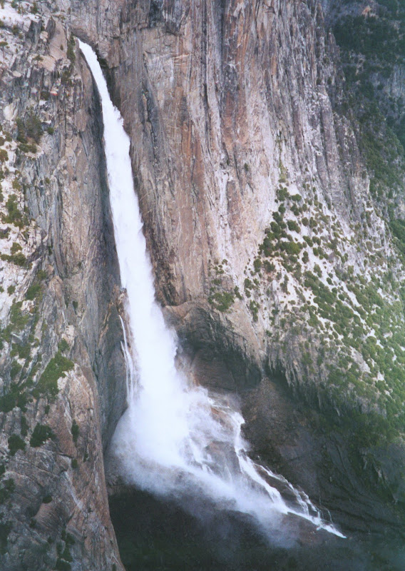
The view looking down on Yosemite Falls from above the Eagle Tower is certainly different, but not necessarily better. I think I called it Eagle's Nest or Eagle Castle on some maps. Here is the view:


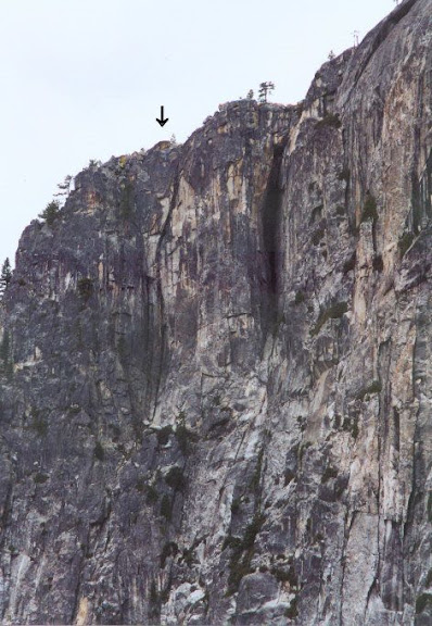
There is a caveat about this viewpoint, however. People are not encouraged to go up there because it is right over the Yosemite Falls Trail, and there have been deaths from rocks falling from that cliff. If you want to photograph a distant object, no problem, but if you want to look down then you need to go to the edge. In most places the edge is rounded and has small lower ledges, so the view is partly obstructed, and trying to get it will endanger people below. There is only one safe place to get right to the edge, and that's by lying on your stomach on a a nice clean overhanging rock. The only thing you can drop off this point is yourself or your camera. Otherwise, stay back from the cliff edge. Here is the point in question:

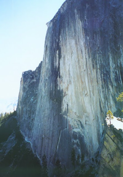
Other photo spots that are neat and probably not yet visited by you include the Diving Board. Here is my version of Ansel Adam's famous 1927 photo. He had a wider angle lens than I did.


There is a similar photo available from the other side of the face, in the grove of trees next to the climbers access trail down from the Half Dome Trail.
Quarter Domes are nice, too. The Ledges Trail is nice photographically, but a stupid place to be for reasons well covered in this forum. The top of Upper Cathedral Rock (#27 on my list) is a great vantage point, and the nearby lip of Bridalveil Falls is an exceptional lookout point when there is low water. Difficult to photograph, though. I always tie myself to a tree before going anywhere near the lip.

This post is long enough. Tells more exactly what you want. Bill-e-q has a ton of photos. You don't have to twist his arm very hard.


Edited 2 time(s). Last edit at 11/09/2012 05:47PM by wherever.
Re: Abandoned trails and off-trail hikes near Yosemite Valley
October 13, 2010 05:23PM
By the way, Old Inspiration Point is an interesting point historically, but the view from there is definitely inferior to that from New Inspiration Point and from the Tunnel View. It is definitely from a different viewpoint, though. Here is the view from Old Inspiration Point:
Re: Abandoned trails and off-trail hikes near Yosemite Valley
October 14, 2010 08:37AM
Quote
wherever
Quote
tanngrisnir3
I'm bumping this older thread because I'm looking for new photographic viewpoints (If I see one more Tunnel View/El Cap from the river/Half Dome from Glacier, etc....) and this was originally a great idea.

Anyone?

Buehler?

Well my original thread was to talk about 32 hikes around around Yosemite Valley. You won't see any distant objects while doing those hikes that you haven't seen before, although they will indeed be from different viewpoints.

What are you looking for? Do you want a good new place for you to take photos yourself, or do you want the novelty of seeing someone else's photos from a different angle? I'm not much of a photographer, and most of my photos are pre-digital and not well organized.

Anyway, here are some comments about places from the original off-trail list:

Easy to get to:

The Devils Dance Floor is a short enjoyable hike from Tamarack Creek Campground. Lots of interesting granite landscaping. The distant view of the Valley from the west is OK, but not any better IMOH than what you get from the hills next to Foresta. In recent years there has been a lot of haze in almost all long distance views at these lower elevations, but you might get lucky.

The absolute best overall view of Bridalveil Falls is from the lower part of the Old Big Oak Flat Road. Easily reached from the Valley and sunny, so it's an excellent choice in the Spring when other hikes still suffer from slippery ice and hard snow.

El Cap Ridge has neat views, but not calendar cover stuff. Ask Chick-on for some of his.

The view looking down on Yosemite Falls from above the Eagles Castle is certainly different, but not necessarily better. I think I called it Eagle's Nest in my list. Here is the view:


There is a caveat about this viewpoint, however. People are not encouraged to go up there because it is right over the Yosemite Falls Trail, and there have been deaths from rocks falling from that cliff. If you want to photograph distant object, no problem, but if you want to look down then you need to go to the edge. In most places the edge is rounded and has small lower ledges, so the view is partly obstructed, and trying to get it will endanger people below. There is only one safe place to get right to the edge, and that's by lying on your stomach on a a nice clean overhanging rock. The only thing you can drop off this point is yourself or your camera. Otherwise, stay back from the cliff. Here is the point in question:

Other got photo spots that are neat and probably not yet visited by you include the Diving Board. Here is my version of Ansel Adam's famous 1927 photo. He had a wider angle lens than I did.


There is a similar photo available from the other side of the face, in the grove of trees next to the climbers access trail down from the Half Dome Trail.
Quarter Domes are nice, too. The Ledges Trail is nice photographically, but a stupid place to be for reasons well covered in this forum. The top of Upper Cathedral Rock (#27 on my list) is a great vantage point, and the nearby lip of Bridalveil Falls is an exceptional lookout point when there is low water. Difficult to photograph, though. I always tie myself to a tree before going anywhere near the lip.

This post is long enough. Tells more exactly what you want. Bill-e-q has a ton of photos. You don't have to twist his arm very hard.

Thanks! I'm thinking specifically of the ones on the south wall of the valley, as I've done some of the ones on the north wall, and as I mentioned, plan to do El Cap Gully very soon. The south wall is something I've driven by my whole life and never, until recently, considered/thought about ascending, as I'm sure millions of other people have also done.

I'm always looking for new photographic perspectives, and assiduously avoid the photos/places that I briefly mentioned, ala Half Dome from Glacier, etc.... It's like photographing the GG Bridge or the Eifel. Just. Not. Interested.
Re: Abandoned trails and off-trail hikes near Yosemite Valley
October 18, 2010 11:54AM
Very interesting list and photographs. Thanks for sharing all these details. I've done Illilouette Gorge and Sierra Point and I'm still trying to get to Rainbow View. Does anybody have a picture of Bridalveil Falls from Rainbow View?
avatar Re: Abandoned trails and off-trail hikes near Yosemite Valley
October 18, 2010 01:40PM
Uh... you asked about this a while ago... here it is again:
http://yosemitenews.info/forum/read.php?1,5236,5351#msg-5351

Some more on the road from awhile ago:
http://yosemitenews.info/forum/read.php?1,3253,3253#msg-3253

And the great writeup by wherever:
http://yosemitenews.info/forum/read.php?3,26668,26668#msg-26668
(which also has a pict from Rainbow View)
Re: Abandoned trails and off-trail hikes near Yosemite Valley
October 18, 2010 05:10PM
Thanks for the links. It was a while ago so I forgot that a picture had been shared. I'm still trying to get to this hike. I want to be in YV at the right time when waterflow over Bridalveil is at its peak.
Re: Abandoned trails and off-trail hikes near Yosemite Valley
June 22, 2011 06:59PM
I will be going to Yosemite in a week and plan to try for the top of Liberty Cap. I've found a few pages on the internet describing the trip but none are very descriptive. Do you have any details on this trip that you could share with me? I'd love to have a kml or gpx or a route but I'll take any help I can get.

Last time I was there I found a cairn off the trail in Little Yosemite not too far from Nevada Fall (much too close to Nevada to be marking the route to the Diving Board) but as I was very tired returning from Half Dome I didn't explore the path leading up from the cairn into the brush.
avatar Re: Abandoned trails and off-trail hikes near Yosemite Valley
June 22, 2011 07:25PM
wherever can add more... but top of Liberty is pretty simple.
Work your way however you like around the backside (you can actually zig right up
from the LYV trail before you do the down portion into LYV)
Once on the backside you will see the gully that you want to go up.
Once in that gully there really aren't a huge number of options.

Play around up there and get a nice view of Nevada Falls:


Chick-on is looking at you!
avatar Re: Abandoned trails and off-trail hikes near Yosemite Valley
June 22, 2011 09:03PM
A shot of the gully you go up:


Maybe it is class 3 but it's pretty easy. Obviously a little brushy.


Chick-on is looking at you!
avatar Re: Abandoned trails and off-trail hikes near Yosemite Valley
June 22, 2011 07:32PM
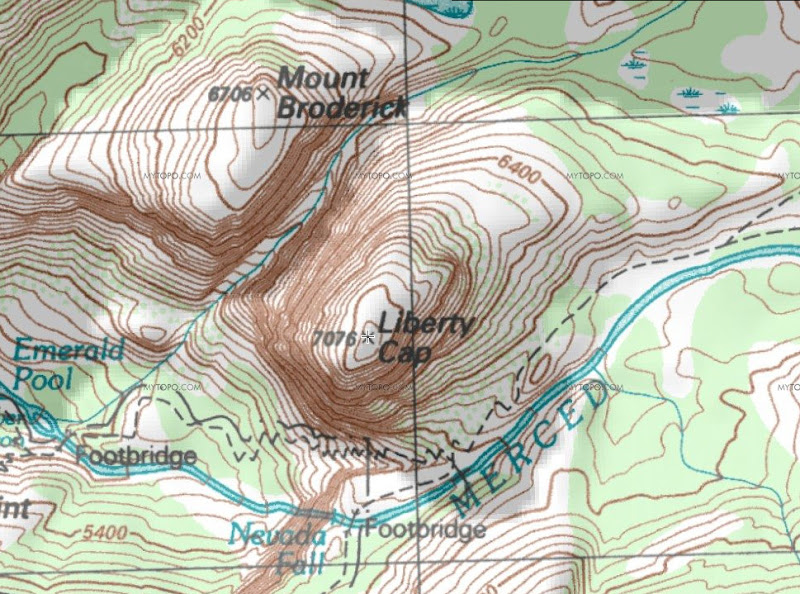
Maybe this map will help:


If you really need waypoint file I guess I could send you one...


Chick-on is looking at you!
Re: Abandoned trails and off-trail hikes near Yosemite Valley
June 22, 2011 09:10PM
Chick-on's map is a little busy. Here is another description.

To get to Liberty Cap from the Valley, head up past Nevada Falls towards Little Yosemite Valley. As you pass Liberty Cap, you will see a ridge above the trail to your left. You want to get up there, but Chick-on's route is steep and brushy. Keep going until you see the trail fork just before Little Yosemite Valley. The right fork follows the river to the campground. The left fork goes on to Half Dome, Cloud's rest, and a view of the LYV toilets. Near that fork you will see several easy places on the left to get up onto the ridge. Approx. N37.72854, W119.53254


Then walk west along the ridge crest to Liberty Cap. If you are good at route finding, you can do this part without touching any bushes. If you are clumsy, you won't.

Liberty Cap is a smooth granite dome with only one flaw: A big crack that runs right up the northeast side. You can see it for miles. As you approach the dome, you come to a brushy scree pile leading up to that crack. There are several well-worn routes up through the bushes. You will touch the brush, and slog up through steep dirt, but if gets to be a problem you have missed a turn.

It is absolutely impossible to get lost on this thing, either going up or down, since you can see where you are going the whole time. There is only one crack, and it's huge. You can, of course, put yourself into the bushes if you want. Roper rates this as class 2, which is only a small notch above the tourist trails.

At the top of the scree pile you reach the crack. It is like a steep creek bed, full of rocks and stuff, but easy to negotiate. There is just one obstacle, which is near the bottom: a big slab of rock lying in the way. You pass it on the right. This is the only place where you will definitely have to put hands on the rock and pay attention. After that you can just stay in the crack, or branch out to the right a bit if you like slick rock.

One other comment. Last time I took some newcomers up there, one was wearing sneakers. Didn't work. They filled up with dirt and gravel immediately. Also, wear long pants unless you are a brush master.
avatar Re: Abandoned trails and off-trail hikes near Yosemite Valley
June 23, 2011 07:09AM
How the heck you remember this?

Usually I just go and look at topo on the way. Or just wing it the entire way. wink
Then come back and read something... and go, o... ok.

But there's a myriad number of ways to get to the gully... that's all.
I x'd from Half a Dome... and then short-cutted to the trail on way down.
It wasn't too bad shrub. If one thinks they will not touch shrub... they'll
be in for a surprise imo.

Here's two more photos for fun:
Z-Gully


Z-Top


Chick-on is looking at you!
Re: Abandoned trails and off-trail hikes near Yosemite Valley
June 23, 2011 04:19PM
Quote
wherever
Chick-on's map is a little busy. Here is another description.

To get to Liberty Cap from the Valley, head up past Nevada Falls towards Little Yosemite Valley. As you pass Liberty Cap, you will see a ridge above the trail to your left. You want to get up there, but Chick-on's route is steep and brushy. Keep going until you see the trail fork just before Little Yosemite Valley. The right fork follows the river to the campground.r.
How far from the Nevada toilet to the fork? I have never been past the toilets.
avatar Re: Abandoned trails and off-trail hikes near Yosemite Valley
June 23, 2011 04:33PM
1/2 to 3/4 mile?

A few switchbacks as you go up a little, then a long meandering straightaway down to the fork. Both trails at the fork go to LYV. Right goes to the river end of the campground, left goes to the bathroom end of the campground. If you're doing HD you'd go to the left.
Re: Abandoned trails and off-trail hikes near Yosemite Valley
June 23, 2011 04:39PM
Quote
hotrod4x5
How far from the Nevada toilet to the fork? I have never been past the toilets.
Just over half a mile.
Re: Abandoned trails and off-trail hikes near Yosemite Valley
June 22, 2011 09:38PM
Wow, thanks for all the great replies in just a couple of hours. Can't wait to try it. Thanks a ton!!
avatar Re: Abandoned trails and off-trail hikes near Yosemite Valley
June 22, 2011 09:45PM
Wherever gave a good description of the easiest route. It's very straightforward. I think this is the "flaw" he mentions is this gully:


Lousy light, sorry, larger version here: http://www.supertopo.com/photos/8/55/207064_4053_XL.jpg

Great views from the top.
Re: Abandoned trails and off-trail hikes near Yosemite Valley
June 23, 2011 12:38PM
sunnyside bench to the bottom of upper yosemite falls is a good one too, anyone ever been down into the indian caves?
avatar Re: Abandoned trails and off-trail hikes near Yosemite Valley
June 23, 2011 05:23PM
Quote
ryanmj
sunnyside bench to the bottom of upper yosemite falls is a good one too, anyone ever been down into the indian caves?

qumqats gave a nice description, etc. here of Sunnyside:
http://yosemitenews.info/forum/read.php?3,27394

I know Wickett has been into the Indian Caves along with a few other tidbits... maybe he is still around to say something.. ????


Chick-on is looking at you!
avatar Re: Abandoned trails and off-trail hikes near Yosemite Valley
June 23, 2011 07:57PM
I'm a bit more apprehensive of the dangers on Sunnyside Bench trail after my last trip and hike on it.

At one point I mis-stepped and fell to my knees and hands in the dirt as I started sliding down slope from the trail.
I didn't slide too far, only a foot or so, but as I knelt there appraising my situation I realized that the slope ended 10 feet or so below me at the cliff face.
opps no, stop, enough!
There were also a couple of places where the trail was wet making it slippery, at places where you don't want to slip. What was easy and carefree last time no longer was.

Looks like I had picked an optimal time for my first trip. smiling smiley

As always, go, do, have fun, but be carefull!

P.S. I'm still looking for how to get up from Sunnyside Bench trail up to Muir's Perch. The best I've found so far is some class 4 to get above Sunnyside ( I didn't try it, late in day, solo )


Edited 2 time(s). Last edit at 06/23/2011 08:11PM by qumqats.
avatar Re: Abandoned trails and off-trail hikes near Yosemite Valley
June 23, 2011 08:33PM
Quote
qumqats

P.S. I'm still looking for how to get up from Sunnyside Bench trail up to Muir's Perch. The best I've found so far is some class 4 to get above Sunnyside ( I didn't try it, late in day, solo )


Question: Is Muir's Perch also called Fern Ledge?

If so, here's a good trail description on how to get there:

http://yosemiteexplorer.com/trails/fern-ledge


If it's a different place, where is Muir Perch in relation to Fern Ledge?
avatar Re: Abandoned trails and off-trail hikes near Yosemite Valley
June 24, 2011 01:16AM
Either I've got the wrong name ( Muir's Perch ), or it's got two names, ( Muir's Perch and Fern Ledge ).

That page is good, and I used it and the photos when I started this search, but it doesn't give a good idea of how to get above Sunnyside Bench.

It makes it sound I should be finding some class 2 or 3 to get up there, not the 4 that is all I've found!
Re: Abandoned trails and off-trail hikes near Yosemite Valley
June 24, 2011 05:22PM
Quote
qumqats
I'm a bit more apprehensive of the dangers on Sunnyside Bench trail after my last trip and hike on it.

At one point I mis-stepped and fell to my knees and hands in the dirt as I started sliding down slope from the trail.
I didn't slide too far, only a foot or so, but as I knelt there appraising my situation I realized that the slope ended 10 feet or so below me at the cliff face.
opps no, stop, enough!
There were also a couple of places where the trail was wet making it slippery, at places where you don't want to slip. What was easy and carefree last time no longer was.

Looks like I had picked an optimal time for my first trip. smiling smiley

As always, go, do, have fun, but be carefull!

P.S. I'm still looking for how to get up from Sunnyside Bench trail up to Muir's Perch. The best I've found so far is some class 4 to get above Sunnyside ( I didn't try it, late in day, solo )
Along that sloped slab with the leaves on it is where you have to be careful, I imagine if you slid there it would be hard to stop. Your lucky
Re: Abandoned trails and off-trail hikes near Yosemite Valley
June 24, 2011 05:19PM
Quote
chick-on
Quote
ryanmj
sunnyside bench to the bottom of upper yosemite falls is a good one too, anyone ever been down into the indian caves?

qumqats gave a nice description, etc. here of Sunnyside:
http://yosemitenews.info/forum/read.php?3,27394

I know Wickett has been into the Indian Caves along with a few other tidbits... maybe he is still around to say something.. ????

They dont go too deep, you drop into a cavern and follow a tunnel to a squeeze into another cavern with a registry. Pretty cool spot but it only goes about 80'.
Re: Abandoned trails and off-trail hikes near Yosemite Valley
June 24, 2011 05:17PM
Its a scramble from sunnyside bench to fern ledge, im going to check it out again in a week, should be nice with all this water
Sorry, only registered users may post in this forum.

Click here to login