

The Moon is Waning Gibbous (87% of Full)
Re: What's wrong with this picture?
All posts are those of the individual authors and the owner
of this site does not endorse them. Content should be considered opinion
and not fact until verified independently.
July 07, 2010 01:23PM | Moderator Registered: 16 years ago Posts: 1,918 |
Taken at tr. jct. near the TM HSC:
July 07, 2010 01:25PM | Admin Registered: 16 years ago Posts: 17,140 |
July 07, 2010 01:32PM | Moderator Registered: 16 years ago Posts: 1,918 |


July 07, 2010 03:42PM | Moderator Registered: 16 years ago Posts: 1,876 |
Quote
bill-e-g
Anyone have a topo map with the trail from Granite Lakes TH to Mono Pass TH on it?
It doesn't show up on either a 1958 topo that I have of the entire park (45' x 1° map) or a 1956 Tuolumne Meadows Quadrangle topo (15' x 15').
However, I do have a March 1967 (Revised 1976) park entrance pamphlet/map that shows it.
(Not surprisingly, it seems the NPS was slow in reporting/recording changes even back then.)
July 07, 2010 04:22PM | Moderator Registered: 16 years ago Posts: 1,918 |
Quote
szalkowski
Quote
bill-e-g
Anyone have a topo map with the trail from Granite Lakes TH to Mono Pass TH on it?
It doesn't show up on either a 1958 topo that I have of the entire park (45' x 1° map) or a 1956 Tuolumne Meadows Quadrangle topo (15' x 15').
However, I do have a March 1967 (Revised 1976) park entrance pamphlet/map that shows it.
(Not surprisingly, it seems the NPS was slow in reporting/recording changes even back then.)
Hmm... I have a 1941 Guide Map and it shows on there.
Anyone take the 5.2 mile trail from Mono TH towards TM?
We ran into that "trail" less than .1 mile from the TH.
Curious how it runs exactly. We could see the Dana Fork and the road for
a good deal of the hike and I never saw a distinct trail b/t the Fork and
the Road. (it was not prudent to cross it and explore unfortunately)
|
Re: What's wrong with this picture? July 07, 2010 04:39PM | Registered: 16 years ago Posts: 759 |
It shows on one of my topo maps. The Nat'l Geographic topo series called "Trails Illustrated: Yosemite National Park" map 206 dated 1987, revised 1996. Is that recent enough?
As far as I know, this map is still for sale in stores.
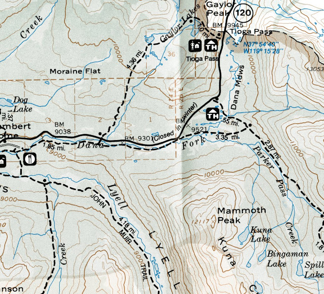
So, you are saying that the trail shown alongside Tioga Pass Highway and Dana Fork of the Tuolumne River no longer exists? Or are you complaining that its intersection with the Mono Pass trail is not where it should be? My map gives mileages for that intersection as 0.55 miles in from the highway and 3.35 miles from the Gaylor/Granite Lakes trailhead.
As far as I know, this map is still for sale in stores.
So, you are saying that the trail shown alongside Tioga Pass Highway and Dana Fork of the Tuolumne River no longer exists? Or are you complaining that its intersection with the Mono Pass trail is not where it should be? My map gives mileages for that intersection as 0.55 miles in from the highway and 3.35 miles from the Gaylor/Granite Lakes trailhead.
July 07, 2010 04:49PM | Moderator Registered: 16 years ago Posts: 1,918 |
Quote
wherever
It shows on one of my topo maps. The Nat'l Geographic topo series called "Trails Illustrated: Yosemite National Park" map 206 dated 1987, revised 1996. Is that recent enough?
As far as I know, this map is still for sale in stores.
So, you are saying that the trail shown alongside Tioga Pass Highway and Dana Fork of the Tuolumne River no longer exists? Or are you complaining that its intersection with the Mono Pass trail is not where it should be? My map gives mileages for that intersection as 0.55 miles in from the highway and 3.35 miles from the Gaylor/Granite Lakes trailhead.
Can you scan that section please and post it or give me a link or.. ???
The trail no longer exists afaik.
I have the Wilderness Press Map (May 1997) - trail not present
I have the 206 - NG Trails Illus (revised 2005) - trail not present
The jct. of the "TM 5.2 miles" sign and the Mono Pass Trail was before the crossing of the Dana Fork
(as you head south)
July 07, 2010 05:03PM | Moderator Registered: 16 years ago Posts: 1,876 |
Quote
wherever
It shows on one of my topo maps. The Nat'l Geographic topo series called "Trails Illustrated: Yosemite National Park" map 206 dated 1987, revised 1996. Is that recent enough?
As far as I know, this map is still for sale in stores.
So, you are saying that the trail shown alongside Tioga Pass Highway and Dana Fork of the Tuolumne River no longer exists? Or are you complaining that its intersection with the Mono Pass trail is not where it should be? My map gives mileages for that intersection as 0.55 miles in from the highway and 3.35 miles from the Gaylor/Granite Lakes trailhead.
The NE Yosemite quadrant National Geographic Trails Illustrated Map of that area (Tuolumne Meadows & Hoover Wilderness; map #308, 2006) doesn't show that section of the trail. Interesting that your larger map #206 (Yosemite National Park) does.
Addendum: just saw Goatie's post. I also have the Wilderness Press 15' topo that doesn't show it.
Edited 1 time(s). Last edit at 07/07/2010 05:06PM by szalkowski.
|
Re: What's wrong with this picture? July 07, 2010 10:57PM | Registered: 16 years ago Posts: 759 |
July 08, 2010 03:11AM | Moderator Registered: 16 years ago Posts: 1,876 |
Neither a 1997 Wildflower Productions TOPO! disk of the park ( Version 1.2.2; labeled "Yosemite, Mammoth, and Central Sierra Wilderness Areas" ) nor a 2006 National Geographic California TOPO! set ( Version 4.2 ) show that section of trail.
Edited 2 time(s). Last edit at 07/08/2010 03:13AM by szalkowski.
Edited 2 time(s). Last edit at 07/08/2010 03:13AM by szalkowski.
July 07, 2010 01:37PM | Moderator Registered: 16 years ago Posts: 1,918 |

|
Re: What's wrong with this picture? July 07, 2010 09:00PM | Registered: 15 years ago Posts: 864 |
This trail is on the 1948 Yosemite map:
http://gisserver.princeton.edu:81/navigatorMapViewer.htm?map=912
I've also seen it on at least one other map. I also recall that there's a sign mentioning Mono Pass on the *north* side of Tioga Road on the Gaylor Lakes trail--perhaps this sign had been on the south side but was relocated? I also remember seeing a trail from the Parker Pass trail to Spillway Lake on some maps (it's an easy cross-country stroll anyway). Oddly, the signed trail heading up to Spillway Lake is not on the latest 7.5' Koip Peak quad. Then again, the faint Parker Pass trail junction near Mono Pass was not even signed until a few years ago. There's also an old road that leads from Tioga Pass to the Mono Pass trail just past the Spillway Lake junction--presumably it was access to the mines at Mono Pass.
July 07, 2010 10:03PM | Moderator Registered: 16 years ago Posts: 1,918 |
Thanks for the link! Haven't seen that one before.
We did investigate a little where the trail crosses the road and heads to Gaylor Lakes.
Didn't see any trail or sign for Mono on S. of road. On North the sign said
"Gaylor Lakes 2.3" & "Tioga Pass 3.3".
Unfortunately haven't been on any of the Gaylor Lakes trails so I don't know anything else
about them. I guess I'll have to run up there and check them out and then follow the
Mono TH to TM trail to see where it heads.
The trail to Spillway is indeed signed now as you mentioned and well worn.
We went that way last Friday and then xcountried up to Parker Pass Lake and
then the pass. We were expecting much more snow than what was there.
Actually didn't see really any until Parker Pass itself.
Anyway, hi again and thanks for the link!
July 08, 2010 07:16AM | Moderator Registered: 16 years ago Posts: 1,918 |
Thanks for all the maps!
I'll have to go and head west on the "TM 5.2 miles" trail from
Mono TH someday and map it out I guess.
All the maps show slightly different things.
btw this what the Dana Fork crossing looked like:
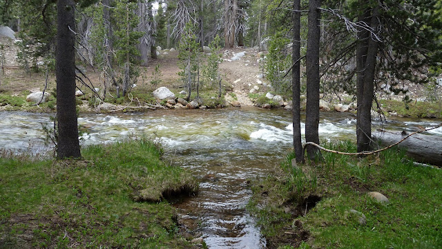
If Parker would have been this bad then we would have hiked all the way back up to Spillway
and someone would have been royally pissed and felt duped again.
(oopsie... we missed the shuttle... let's just hike back to our car...
we hiked this far... we can't do another 5 miles?? geez... )
I'll have to go and head west on the "TM 5.2 miles" trail from
Mono TH someday and map it out I guess.
All the maps show slightly different things.
btw this what the Dana Fork crossing looked like:
If Parker would have been this bad then we would have hiked all the way back up to Spillway
and someone would have been royally pissed and felt duped again.
(oopsie... we missed the shuttle...
let's just hike back to our car...we hiked this far... we can't do another 5 miles?? geez... )
July 12, 2010 07:13AM | Moderator Registered: 16 years ago Posts: 1,918 |
An interesting note (at least to me)...
The sign at Olmstead Point used to say:
"Snow Creek" w/ an Arrow
Either someone stole that sign (unlikely IMO since the other two
signs there are the same). Or the powers that be
decided that had to dumb-ify it.
It has been replaced with:
"Yosemite Valley" w/ an Arrow
So... w/ this in mind kinda confused why they would leave
no longer maintained trail signs even up. (the TM 5.2 isn't the
only one) (anyone wanna have 4.4 miles o fun and go from
the Middle fork down to Ackerson Mdws?)
Anyway, love the signs. Just was surprised they changed the snow creek one.
November 18, 2013 07:54AM | Moderator Registered: 15 years ago Posts: 7,421 |
Finally took this 5.2 mile trail...
It turns out it's THE Old Tioga Road...
Hits it a couple of times S of New Tioga... then when it crosses...
it's THE Old Tioga Road all the way to the Gaylor/Granite Lakes
trail. Anyone hiking ALL the trails in Yosemite... yeah... you HAVE to do this trail.


It turns out it's THE Old Tioga Road...
Hits it a couple of times S of New Tioga... then when it crosses...
it's THE Old Tioga Road all the way to the Gaylor/Granite Lakes
trail. Anyone hiking ALL the trails in Yosemite... yeah... you HAVE to do this trail.
November 19, 2013 07:41AM | Moderator Registered: 15 years ago Posts: 7,421 |
It looks like this:

Blue is the trail from Mono Pass TH to the Granite/Gaylor trail. The Red is other portion of the Old Tioga Road.
The Blue is almost entirely cept a very very very small portion at the beginning The Old Tioga Road.
Why this is not on any map is beyond me. Yes, the old road is... but it should be on maps nowadayz b/c it
is a maintained trail.
November 19, 2013 11:01AM | Registered: 16 years ago Posts: 4,174 |
Quote
chick-on
Yes, the old road is... but it should be on maps nowadayz b/c it
is a maintained trail.
Let me get it straight.
The Park Service still shows, as a maintained trail, the portion of the old Tioga Road between the Yosemite Creek Campground and Porcupine Flat Campground on their maps though almost all of it is an overgrown mess of deadfall, shrubs and pine and fir saplings, but they don't show this portion of the old Tioga Road (between the Gaylor Lakes trail and the Mono Pass trailhead) even though it is a maintained trail.
Go figure...

Edited 1 time(s). Last edit at 11/19/2013 11:31AM by plawrence.
November 20, 2013 07:16AM | Moderator Registered: 15 years ago Posts: 7,421 |
It didn't used to be on the park map. Somebody back in about the 1980s is my guess
(not gonna look it up) walked the old road and decided it was in decent enough shape
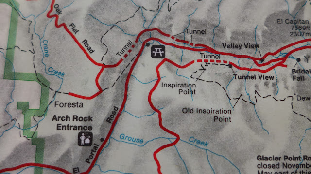
and had enough power to put it on the new map. The Old Coulterville Road from
140 up to Foresta used to be on the park map. They took that off.
In their defense I've hike Old Tioga Road from Yose Creek up three times now... and
the first two times it wasn't that bad... it's gotten much much worse over time.
Old Coulterville:
Older Park Map w/o Old Tioga on it:

(not gonna look it up) walked the old road and decided it was in decent enough shape
and had enough power to put it on the new map. The Old Coulterville Road from
140 up to Foresta used to be on the park map. They took that off.
In their defense I've hike Old Tioga Road from Yose Creek up three times now... and
the first two times it wasn't that bad... it's gotten much much worse over time.
Old Coulterville:
Older Park Map w/o Old Tioga on it:
|
Re: What's wrong with this picture? November 21, 2013 04:37PM | Registered: 13 years ago Posts: 262 |

November 22, 2013 06:47AM | Moderator Registered: 15 years ago Posts: 7,421 |
December 05, 2013 06:02AM | Moderator Registered: 16 years ago Posts: 1,882 |

Sorry, only registered users may post in this forum.

