Hi All - I'm looking to get some advice on a trip:
I plan to do 6 days, 5 nights, in a loop from Hetch Hetchy to Jack Main Canyon area and back during the second week in May 2011. I've spoken to a ranger and understand that snow will be something to expect. My group (4-8 people) are all Minnesotans and we enjoy the cold! We also have no problem with snowshoes and snow camping.
However, despite our temperament, I'm concerned that my planned route would simply be inaccessible due to deep snow, bridge outages, or heavy currents. Although it's hard to predict at this time, can anyone comment further on what to expect? What type of winter has it been out there so far? Is the Wapama falls bridge really not crossable even for able-bodied men? If we have a map/compass and the trails are generally there, we can still cross-country, right?
Thanks for the advice, Max

The Moon is Waning Gibbous (70% of Full)
Re: Backpacking Hetch Hetchy in May
All posts are those of the individual authors and the owner
of this site does not endorse them. Content should be considered opinion
and not fact until verified independently.
|
Backpacking Hetch Hetchy in May January 02, 2011 04:50PM | Registered: 14 years ago Posts: 11 |
January 02, 2011 06:01PM | Moderator Registered: 16 years ago Posts: 1,918 |
If they don't rebuild the missing section of bridge before your trip... and you go Mid-May next year...
I would not count on being able to cross. Right now two sections are just I beams.
I doubt they will even give you a permit if you say you are going thru Rancheria.
The reservoir will probably be very full and the river roaring... and probably the only
safe way over is on the I Beam. I certainly would PLAN on being able to cross it.
All that being said... that shouldn't dissuade you IMO. Just getting into JMC and then coming
back out is worth it IMO.
What can you expect? Well... if things continue... then once you hit Beehive you're gonna have
snow... and could be a lot... but.. by then it will have consolidated and you can probably walk on it.
(I'd bring shoes myself though if things continue as they do for the hike up Moraine Ridge)
Problem is... it will be a mosh pit after Beehive and you may want to get off the trail and hike up
on one of the ridges to hook up with Moraine Ridge.
Down the golden staircase (trail down into JMC from Moraine Ridge) will def. be a river but
should be doable.
Once in the canyon there are a number of spots where the water will be so high you will have
to wade thru water or turn around.
Spot 1 is WM 7643 pond. You'll have to thrash and bash up higher or give up here.
Next spot is call Paradise Valley.. it will be a mosh pit too... (it's the area just before the
first trail jct.)
Next spot where the trail WILL be under water is beyond the first trl. jct. where the river gets
very close to the trail.
The river will prob. be flowing too high for comfort to cross at the first trl. jct... but at Wilma
you can probably cross but... that's up to you.
SOOO... what would I do?
I'd get the permit to go into Jack Main and come back out the same way... you can always
bop down to Vernon if things get too messy or uncomfortable..
Go all the way up as far as Grace Meadow... and then just come back...
and don't HAVE to go over "there"...
o... and if you see some schmo in there then... I wouldn't doubt it's me...
I love that Canyon. (although I'll prolly go even earlier)
One other thing... Tilltil Valley will be nice and soupy then too.
My general rule of thumb is... Memorial Day = Snow at 7500 ft. level
although last year it was more like 6500
This may give you an idea:
Memorial Day - 2010
http://picasaweb.google.com/yosemite.chick.on/Nance#
Been in JMC that time of year too... and thus my comments... although
the trail can be flooded (and probably will be in 2011) into July
Have fun
January 02, 2011 06:17PM | Moderator Registered: 16 years ago Posts: 1,918 |

January 03, 2011 08:13AM | Moderator Registered: 16 years ago Posts: 1,918 |
To give you another idea...
Here's the spot where the trail will def. be under water.
This was JULY 2, 2006:
I'd expect this or worse... if you decide to slosh your way this far and haven't given up.
Paradise Valley's trail is risen... but there will be streams flowing across..
Good luck... or wait until later in the year
(I've contemplated bringing a boat to cross 7643)
(but then again... people who really know me.... know I have all kinds of kookie ideas)
February 02, 2011 12:21AM | Moderator Registered: 16 years ago Posts: 1,347 |
Quote
bill-e-g
(I've contemplated bringing a boat to cross 7643)
(but then again... people who really know me.... know I have all kinds of kookie ideas)
Every time I hike or backpacked near lakes, I always wish that I had a trail boat with me; I could probably spend extra days in the same area just dragging the boat around exploring all of the ponds/lakes.
The body betrays and the weather conspires, hopefully, not on the same day.

February 02, 2011 12:45AM | Admin Registered: 16 years ago Posts: 17,140 |
February 02, 2011 07:39AM | Registered: 15 years ago Posts: 7,421 |
Quote
eeek
Quote
Bee
Every time I hike or backpacked near lakes, I always wish that I had a trail boat with me;
You probably wouldn't wish that on the hike up the hill to get to said lakes.
It's not that heavy. A number of pictures here were taken on my "Boatin' Branigans" little trip.
But not this one:
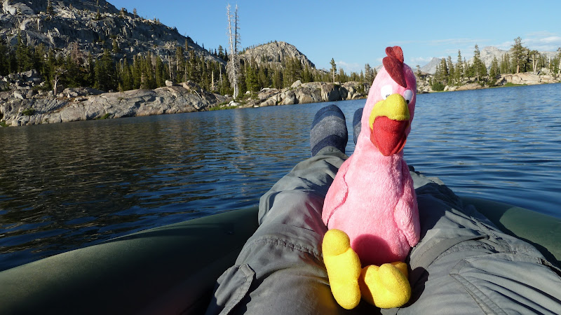
With the boat you can avoid some nasties, have a lot of fun, hit an island without getting your feets wet, etc.
Saved me a lot of time checking off Upper Penn. last year.

February 02, 2011 07:53AM | Registered: 16 years ago Posts: 2,321 |
|
Re: Backpacking Hetch Hetchy in May February 02, 2011 11:32AM | Registered: 15 years ago Posts: 1,770 |
February 02, 2011 01:55PM | Registered: 15 years ago Posts: 7,421 |
Quote
hotrod4x5
Boats on a backpacking trip? How big are they? What do they weight? Got a link to a product page?
Heck ya! Been doing it for years and years. Boated a large number of lakes in NW Yose:
Kibbie, Eleanor, Gravel Pit, Laurel, Vernon, Branigans (all 3), Many Island, Mercur,
Otter, Peninsula... to name a few...
You can see the boat in the picture above...
Loads of fun. Sevylor Trail Boat - < 4 lbs. with oars. Unfortunately you can't find them anymore.
For some reason... just last year, Sevylor quit selling them. Bummer b/c they work just great for lakes.
Now the only thing I can find is a boat that is 4x what the Seylor cost.
Flytepacker Packraft
Talked a little about boats here too:
http://yosemitenews.info/forum/read.php?3,26350,26350#msg-26350
Have fun
|
Re: Backpacking Hetch Hetchy in May February 02, 2011 03:49PM | Registered: 15 years ago Posts: 923 |
February 02, 2011 09:55PM | Registered: 15 years ago Posts: 7,421 |
Quote
AlmostThere
Do searches on pack rafts, or pack rafting. Lots of people doing it, a few packable options available.
There may be a lot of people doing it... but I think you should strike the "a" from the sentence above.
Alpacka, Flyweight, ... and... I couldn't find any others... please amuse me.
(I'm serious!) Flyweight is 3 bills.... Alpacka is > 4 bills... Sevylor... < 1 bills... but not available anymore.
(I need a new boat) (mine has a small problem... )
February 02, 2011 10:00PM | Registered: 16 years ago Posts: 2,321 |
February 02, 2011 10:10PM | Moderator Registered: 16 years ago Posts: 1,347 |
Cool! I love the picture of The Bird at the helm (he should be facing the other direction so he can bee one of those ornaments)
Do you have any peek-chures of your pack with the boat in it (did it take much room?)
As far as weight goes, after toting 4 Larries of water up to Whitney Summit, I am sure that I am up for anything kooky.
The body betrays and the weather conspires, hopefully, not on the same day.
Edited 1 time(s). Last edit at 02/02/2011 10:11PM by Bee.
February 02, 2011 10:43PM | Registered: 15 years ago Posts: 7,421 |
Have pictures taken while in boat with pack in it. But this one is much better that
was taken by "Rocky the pinecone". It's bill-e on Otter Lake:
(typically he will take off his shoes in case something really bad would happen)
(in the background is Tower Peak)

Pretty much what we did was we got to the lake and we jumped in boat with our
gear and paddled around to where we were gonna setup camp.
(thus why we're in the boat with all our gear)
The other people... they walked around to the campsite area...
was taken by "Rocky the pinecone". It's bill-e on Otter Lake:
(typically he will take off his shoes in case something really bad would happen)
(in the background is Tower Peak)
Pretty much what we did was we got to the lake and we jumped in boat with our
gear and paddled around to where we were gonna setup camp.
(thus why we're in the boat with all our gear)
The other people... they walked around to the campsite area...
February 19, 2011 08:45PM | Registered: 16 years ago Posts: 305 |
Quote
chick-on
Have pictures taken while in boat with pack in it. But this one is much better that
was taken by "Rocky the pinecone". It's bill-e on Otter Lake:
(typically he will take off his shoes in case something really bad would happen)
(in the background is Tower Peak)
Pretty much what we did was we got to the lake and we jumped in boat with our
gear and paddled around to where we were gonna setup camp.
(thus why we're in the boat with all our gear)
The other people... they walked around to the campsite area...
That is so cool. I need to do this sometime soon. I've never even heard of "pack" boats like this.
February 28, 2011 03:04PM | Admin Registered: 16 years ago Posts: 17,140 |

|
Re: Backpacking Hetch Hetchy in May March 27, 2011 12:34AM | Registered: 14 years ago Posts: 55 |
April 27, 2011 04:11PM | Moderator Registered: 16 years ago Posts: 1,876 |

April 27, 2011 05:22PM | Registered: 16 years ago Posts: 4,174 |
Here's a short video of the Sevylor Trail Boat in action, courtesy of an Amazon.com reviewer:
Amazon.com: Sevylor Inflatable Trail Boat (Customer Review)
Amazon.com: Sevylor Inflatable Trail Boat (Customer Review)
April 28, 2011 07:20AM | Registered: 15 years ago Posts: 7,421 |
Mr. President,
It is nice to know there are crazier people out there than me.
The review should have been titled "how to ruin your boat".
or "I used it 3 times and then threw it down a cliff".
They don't make the boat anymore. Perhaps they kept changing
it some (since two of the reviews whine about the oars, which
are anything but flimsy on my model).
Probably plenty of people out there doing this sort of thing, but
not in the Sevylor... did enjoy the video though, looks like his
buddy has a FlytePacker.
|
Re: Backpacking Hetch Hetchy in May April 28, 2011 06:01PM | Registered: 15 years ago Posts: 74 |
Quote
plawrence
Here's a short video of the Sevylor Trail Boat in action, courtesy of an Amazon.com reviewer:
Amazon.com: Sevylor Inflatable Trail Boat (Customer Review)
That guy must have brass ones. I took a larger Sevylor across the Colorado last month, and it was the first thing thrown in the garbage at the end of the hike. Still water might be one thing, but the raft sagged a little bit too much for comfort (for me) to be in a current.

Will it float? by urbandispute, on Flickr
Edited 2 time(s). Last edit at 04/28/2011 06:13PM by bbb.
April 28, 2011 07:23PM | Registered: 16 years ago Posts: 2,321 |
April 28, 2011 07:37PM | Admin Registered: 16 years ago Posts: 17,140 |
|
Re: Backpacking Hetch Hetchy in May February 02, 2011 10:11PM | Registered: 15 years ago Posts: 923 |
February 02, 2011 10:46PM | Registered: 15 years ago Posts: 7,421 |
Thanks. I did see NSR before.
Hadn't see the other one though... but dang, that's heavy... getting to be too much there IMO.
Maybe I nixed all the others so far b/c flyweight was the cheapest and lightest...
I'd already have one... but they were out of stock for a couple months now.
Anyway, many thanks.
Hadn't see the other one though... but dang, that's heavy... getting to be too much there IMO.
Maybe I nixed all the others so far b/c flyweight was the cheapest and lightest...
I'd already have one... but they were out of stock for a couple months now.
Anyway, many thanks.
|
Re: Backpacking Hetch Hetchy in May January 03, 2011 10:40AM | Registered: 14 years ago Posts: 11 |
January 03, 2011 01:49PM | Moderator Registered: 16 years ago Posts: 1,918 |
Laurel, Vernon, Wilma, and Tilden are all great fishing IMO.
Last time I brought a pole was in 2006 though... had great idea of fishing Tilden and
Dorothy Lakes... but... guess what? Tilden was frozen over and so was Dorothy.
Fished Dorothy a bit but gave up quickly and instead climbed Forsyth.
We didn't even get to Tilden b/c Falls Creek was screaming and we had no intention
of ending up in Hetchy Hetchy... Remember ... this was JULY. JULY.
In middle of May... next year... I wouldn't doubt that Laurel is still frozen over...
and if not... Frog Creek probably will be flowing too strong for you to cross..
(I've crossed Frog upstream on logs in April on a lower snow year... if I'd gone later...
don't know if I would risk crossing... as it would be flowing much faster)
(also crossed it then by fording it where the trail crosses it on way to Eleanor/Miguel)
In mid-May... I wouldn't bother with a pole except maybe Vernon. The other places you
may not end up going. Falls Creek itself has fish... but I've never had any luck in the
creek itself.
Many of the other lakes in that area do not have fish or the fishing just sucks.
I personally wouldn't bother with a pole in Mid-May unless you are spending plenty of time
at Vernon. The creeks are just flowing too fast then and there is too much uncertainty
or where you will go... esp. since you haven't been there before.
Can tell you more about conditions as it gets closer as we will know the snowpack and
I'll probably have run up there.
Have fun
January 03, 2011 02:01PM | Moderator Registered: 16 years ago Posts: 1,918 |
Here's another photo for you to contemplate:

This is the view from Forsyth Peak. Again JULY (I think 4th) of 2006.
On the left you can hopefully see Tilden Lake (it's frozen). On the right is Grace Meadow. In the middle is Keyes Peak.
If you compare the 2006 snow pack to the 2011 closer to May... you'll be able to get an idea of what to expect in more clarity.
January 03, 2011 02:04PM | Moderator Registered: 16 years ago Posts: 1,918 |
In case you missed it... this is what Vernon area looks like in winter:
http://yosemitenews.info/forum/read.php?3,30771,30771#msg-30771
http://yosemitenews.info/forum/read.php?3,30771,30771#msg-30771
January 04, 2011 07:23AM | Moderator Registered: 16 years ago Posts: 1,918 |
Max,
Was gonna mention a few other things... but then remembered someone asked about
similar things on another forum... you should really read this thread:
http://www.yosemite.ca.us/forum/viewtopic.php?t=1169
Thing to bear in mind is that going earlier doesn't nec. make it not doable. Water may
not actually be as high and snow instead of running water may cover the trail.
Of course you need to be able to navigate over snow with map/compass and be
comfortable w/water crossings. Do what you and your group are comfortable doing.
Another thing to consider is bringing an extra pair of shoes and about 3 pairs of
socks... change into them when wading thru water then change back into dry pair when
safe to do so.
To see the best of JMC you really want to get all the way to Wilma, which in early season
conditions, for a first timer, you should allocate 3 days.
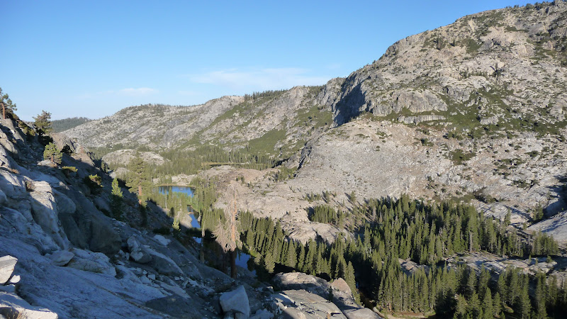
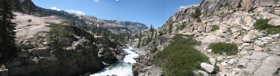
Here's a couple more photos from below Andrews that shows more of the canyon:
(the meadowy area is Paradise Valley... and you can see how the water would be
running thru it)

Good luck
(btw ... been chucking peeps over to this forum b/c I like it way more and it gets way more traffic)
(although it'd be nice if there were more trip reports)
Was gonna mention a few other things... but then remembered someone asked about
similar things on another forum... you should really read this thread:
http://www.yosemite.ca.us/forum/viewtopic.php?t=1169
Thing to bear in mind is that going earlier doesn't nec. make it not doable. Water may
not actually be as high and snow instead of running water may cover the trail.
Of course you need to be able to navigate over snow with map/compass and be
comfortable w/water crossings. Do what you and your group are comfortable doing.
Another thing to consider is bringing an extra pair of shoes and about 3 pairs of
socks... change into them when wading thru water then change back into dry pair when
safe to do so.
To see the best of JMC you really want to get all the way to Wilma, which in early season
conditions, for a first timer, you should allocate 3 days.
Here's a couple more photos from below Andrews that shows more of the canyon:
(the meadowy area is Paradise Valley... and you can see how the water would be
running thru it)
Good luck
(btw ... been chucking peeps over to this forum b/c I like it way more and it gets way more traffic)
(although it'd be nice if there were more trip reports)
|
Re: Backpacking Hetch Hetchy in May January 04, 2011 08:36AM | Registered: 14 years ago Posts: 11 |
January 04, 2011 09:56AM | Moderator Registered: 16 years ago Posts: 1,918 |
Quote
mpuchtel
I just submitted by wilderness permit today!
By the way, what time of year were the two above photos taken? It looks gorgeous!
Again, good luck. That early, you really need to be flexible and go with an open mind...
Doubt you needed to reserve permit... but better safe than sorry when coming in from so far away.
I meant 3 days IN to Wilma, just in case there is any confusion on that part, not 3 days total.
Pictures above dates are:
First one w/ trail drawn: May 31, 2008
2nd one w/Old Dude: July 2, 2006
Last two: Sept. 13, 2008
The first and last two are taken way off trail... (didn't even go into JMC on the Sept. trip)
Edited 1 time(s). Last edit at 01/04/2011 09:56AM by bill-e-g.
January 04, 2011 09:08PM | Moderator Registered: 16 years ago Posts: 1,918 |
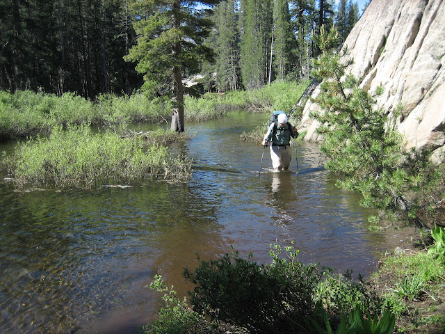
Probably had enough but... Was looking again to see if had better shot of what we
had to go thru thru Paradise Valley... and found this gem:
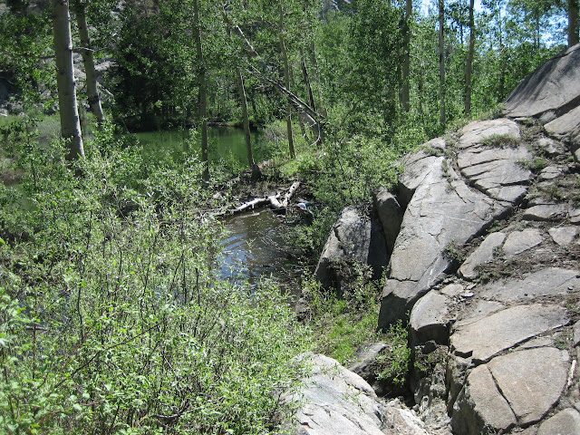
This is the old guy wading thru a part of the trail that was under water near the isthmus.
I do have shots of Paradise... but they're ho hum compared to the old dude wading pix.
If you do make it to about a mile before Wilma where the river splits in two... it's really sweet there.
Looking downstream:
And here's a video (The Old Dude is hiking towards me on the trail)
Hope you enjoy
(it should be obvious you will need much resolve to get all the way to Wilma...)
(and yes, I have thousands and thousands of pictures)
had to go thru thru Paradise Valley... and found this gem:
This is the old guy wading thru a part of the trail that was under water near the isthmus.
I do have shots of Paradise... but they're ho hum compared to the old dude wading pix.
If you do make it to about a mile before Wilma where the river splits in two... it's really sweet there.
Looking downstream:
And here's a video (The Old Dude is hiking towards me on the trail)
Hope you enjoy
(it should be obvious you will need much resolve to get all the way to Wilma...)
(and yes, I have thousands and thousands of pictures)
January 04, 2011 09:40PM | Registered: 14 years ago Posts: 1,351 |
January 05, 2011 07:35AM | Moderator Registered: 16 years ago Posts: 1,918 |
Quote
ttilley
Cool pictures!
Question though...does the Old Dude have pictures of you wading through this stuff?
I don't wade thru that stuff.... I go up on the rocks.

Old Dude is like the Little Engine that Could, too busy to take pictures and thinking:
- I did this a "few years ago", I can do it
- What the?!
- He lied to me again! 1 mile, my butt!
- I'm gonna kill him!
- Why do I agree to this?
- mmmm, pillow...
Seriously... OD is pretty awesome. He's OLD. And he just puts one foot in front of the other and
gets er done.
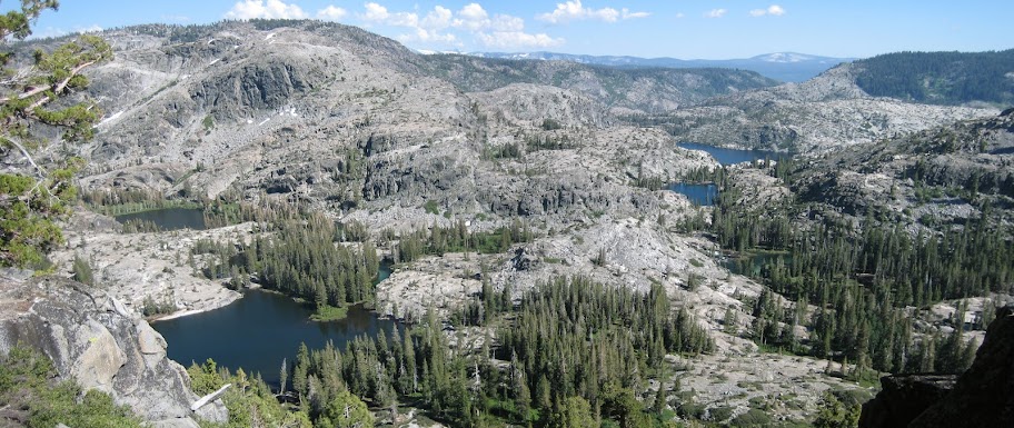
Here's a better one of the canyon taken by Ardeth:
(the lake furthest upper right-ish is Branigan)
January 04, 2011 09:19PM | Moderator Registered: 16 years ago Posts: 1,918 |
|
Re: Backpacking Hetch Hetchy in May January 05, 2011 07:58AM | Registered: 15 years ago Posts: 923 |
Quote
bill-e-g
Ok, you're bored now.
But... THIS is my favorite video from one of the trips into Jack Main Canyon:
Wildlife in action.
As dangerous as the N. Pacific Rattlesnake, faster than the Mountain Lion,
smarter than a Yosemite Black Bear.
(got nothing on Yosemite
I seen those. Thank goodness for bear canisters, it was a narrow thing, I barely crammed myself inside and I almost couldn't get the lid on before the toad leapt up and -
No, I can't. Too graphic.
January 08, 2011 05:12AM | Registered: 14 years ago Posts: 424 |
Bill-e, great pics of Branigan looking back from Ardeth. I've always kicked myself that I didn't go up and check out Branigan the last time I was at Vernon. That and going into Jack Main Canyon are on my list for this season.
As for the fishing, by no means am I a fisherman, however a few of my buddies are, and I can vouch that Vernon is good fishing. I don't know about Laurel, but having been to Laurel once, I have no real desire to go back again. If you've made it to Beehive, you might as well go to Vernon. Laurel is like a bad decision at the bar after last call that you'll regret the next morning.
Thanks for the link to the thread to the other forum on the question last year, I wasn't active much on the forums back then otherwise I would have responded as well. I was up at Miwok and Bear Up back in either 08 or 09 in mid to late June and there was still a decent amount of snow there. Miwok was pretty, but Bear Up is one that I can cross off the map and have no desire to go back again. It was boggy and mosquito heaven. We didn't circle the whole lake (dayhiked down from Miwok), but from what I saw there wasn't a decent campsite anywhere around the lake.
As for the permit, I agree, I'd be 99% sure that you won't need to reserve one in mid May, however when you're coming from far away, why take the risk? Better safe than sorry.
Oh and 1 mile more? Come on now, the standard answer is half a mile. How much longer? "Half a mile". Run into someone on the trail and ask, how far is the lake? "Half a mile"
Edited 1 time(s). Last edit at 01/08/2011 05:31AM by oakroscoe.
January 08, 2011 08:53AM | Registered: 16 years ago Posts: 1,882 |
Quote
oakroscoe
Bill-e, great pics of Branigan looking back from Ardeth. I've always kicked myself that I didn't go up and check out Branigan the last time I was at Vernon. That and going into Jack Main Canyon are on my list for this season.
As for the fishing, by no means am I a fisherman, however a few of my buddies are, and I can vouch that Vernon is good fishing. I don't know about Laurel, but having been to Laurel once, I have no real desire to go back again. If you've made it to Beehive, you might as well go to Vernon. Laurel is like a bad decision at the bar after last call that you'll regret the next morning.
Thanks for the link to the thread to the other forum on the question last year, I wasn't active much on the forums back then otherwise I would have responded as well. I was up at Miwok and Bear Up back in either 08 or 09 in mid to late June and there was still a decent amount of snow there. Miwok was pretty, but Bear Up is one that I can cross off the map and have no desire to go back again. It was boggy and mosquito heaven. We didn't circle the whole lake (dayhiked down from Miwok), but from what I saw there wasn't a decent campsite anywhere around the lake.
As for the permit, I agree, I'd be 99% sure that you won't need to reserve one in mid May, however when you're coming from far away, why take the risk? Better safe than sorry.
Oh and 1 mile more? Come on now, the standard answer is half a mile. How much longer? "Half a mile". Run into someone on the trail and ask, how far is the lake? "Half a mile"
In Mexico they don't even give you mileage; they just say,"directo" with a wave of the hand indicating more or less 180 degrees of compass heading.
January 08, 2011 04:16PM | Admin Registered: 16 years ago Posts: 17,140 |
|
Re: Backpacking Hetch Hetchy in May January 09, 2011 05:49PM | Registered: 14 years ago Posts: 11 |
|
Re: Backpacking Hetch Hetchy in May January 09, 2011 07:01PM | Registered: 15 years ago Posts: 923 |
January 10, 2011 11:01AM | Moderator Registered: 16 years ago Posts: 1,918 |
Quote
mpuchtel
Bill-e, where exactly is the paradise valley you are describing? I don't see it on my NG map.
I put a photo of it above. That big meadowy area... it's right in Jack Main (not on the way
)Just before the first trail jct. as you head up Canyon... or South of Mahan Lake (not Ardeth).
There is a snow survey meter there... unfortunately it is not working... with it you'd really know what
the condition was (how much snow is still there)... you can look here:
http://cdec.water.ca.gov/snow/current/snow/pillowplots/TuolumneMerced.html
I'm planning on heading in the canyon May 7 so I'll let you know what happens...
(right now... I'm expecting to snowshoe from Beehive up... and am contemplating
bringing Scuba booties) (I'm not kidding)
Have fun
|
Re: Backpacking Hetch Hetchy in May January 10, 2011 01:14PM | Registered: 15 years ago Posts: 923 |
January 10, 2011 01:31PM | Moderator Registered: 16 years ago Posts: 1,918 |
Quote
AlmostThere
Having just postholed in snowshoes in Mariposa Grove, scuba booties sound like an awesome idea to me....
Ooops... Sorry if I misead.. Maybe a misunderstanding...
The Scuba Booties would be for wading butt cold (probably in the 30's or 40's) water like in the photos above... not for snow shoeing...
My feet become excruciatingly painful when having to walk in such water (prob. even 50's)..
|
Re: Backpacking Hetch Hetchy in May January 11, 2011 05:07PM | Registered: 15 years ago Posts: 923 |
January 11, 2011 06:11PM | Registered: 16 years ago Posts: 2,321 |
January 11, 2011 07:51PM | Registered: 14 years ago Posts: 1,351 |
|
Re: Backpacking Hetch Hetchy in May January 27, 2011 06:54AM | Registered: 14 years ago Posts: 11 |
January 27, 2011 09:21PM | Registered: 15 years ago Posts: 7,421 |
Quote
mpuchtel
Hi All -
The advice so far has been great. However, if I determine later in the season that the conditions in Hetch Hetchy are indeed too unfavorable for my planned trip, what other options would you recommend for that time of year? Either in Yosemite or in the Seirra Nevada?
Thanks, Max
Max, there are loads o places to go in May. You said yourself that you are a survivalist, so
with the right equipment you can go just about anywhere.
But seriously, if you've never been to Yosemite... prolly go up the Happy Isle up the
Merced to Washburn or further... then turn around and come back. Other places are
fine and dandy... but ... that canyon is just spectacular.
As far as Jack Main is concerned... we'll be in there May 7th and report back... only
way not going is if it is gonna be >70% chance o rain. Other than that, we don't care
about the conditions... that's what makes it fun.
Been plenty o other places in the Sierra... Yosemite wins it all for us... so I won't
mention any others...
Have fun
January 27, 2011 09:25PM | Registered: 15 years ago Posts: 7,421 |
O... and if you haven't seen the Kolana Rock thread... that's Hetch Hetchy...
http://yosemitenews.info/forum/read.php?3,31617
You can see how right now the trails are all def. clear to 6K right now...
but we've really had some GOOFY weather lately... abs. no snow...
and super warm... so it's really impossible to say what the future holds.
And, again, don't count on Wapama Falls bridge being up in May...
|
Re: Backpacking Hetch Hetchy in May January 29, 2011 11:44AM | Registered: 14 years ago Posts: 11 |
From the yosemite website it seems like the "Happy Isle up the Merced to Washburn" idea isn't accessible (due to the road closures to the trailhead) by early May. That's the main reason I've been planning for Hetch Hetchy: its access at that time and the solitude. I plan to be hiking in on the 8th so maybe we'll see each other.
Like you said, there does seem to be large range of conditions possible. Parts of this post say to expect waist-deep snow and some of your photos show no snow at all right now <6000ft in January. I guess I'll need to wait to assess conditions and therefore plan equipment appropriately.
On another note, do you have any suggestions for snowshoe rental in the area? Perhaps outdoor clubs or outfitters? I don't plan to bring a pair all the way from Chicago.
January 29, 2011 11:55AM | Registered: 14 years ago Posts: 1,351 |
|
Re: Backpacking Hetch Hetchy in May January 29, 2011 01:41PM | Registered: 14 years ago Posts: 628 |
It's true that you can't park RIGHT at HI...the closest you can get is, I believe, the Curry parking lot (so far as I know, that's true year-round although I've only been to the Park once in the winter and didn't try to get down to the HI area). Depending on where you park in the lot, it's only about 0.5 or 0.75 miles to the trailhead.Quote
mpuchtel
From the yosemite website it seems like the "Happy Isle up the Merced to Washburn" idea isn't accessible (due to the road closures to the trailhead) by early May.
--David
January 29, 2011 02:01PM | Moderator Registered: 16 years ago Posts: 1,918 |
Quote
DavidK42
It's true that you can't park RIGHT at HI...the closest you can get is, I believe, the Curry parking lot (so far as I know, that's true year-round although I've only been to the Park once in the winter and didn't try to get down to the HI area). Depending on where you park in the lot, it's only about 0.5 or 0.75 miles to the trailhead.Quote
mpuchtel
From the yosemite website it seems like the "Happy Isle up the Merced to Washburn" idea isn't accessible (due to the road closures to the trailhead) by early May.
--David
Trailhead parking is beyond Curry. (don't turn into Curry Village, keep going):
Here's a map with Trailhead marking marked:
http://www.nps.gov/yose/planyourvisit/upload/valleyshuttle.pdf
If you've never been... keep going past Curry Village... then at next turn where
it says road closed, authorized vehicles you should see a TH Parking sign.
Keep going straight. You can't miss it... hahaha
January 30, 2011 08:38AM | Registered: 16 years ago Posts: 1,882 |
Quote
bill-e-g
Quote
DavidK42
It's true that you can't park RIGHT at HI...the closest you can get is, I believe, the Curry parking lot (so far as I know, that's true year-round although I've only been to the Park once in the winter and didn't try to get down to the HI area). Depending on where you park in the lot, it's only about 0.5 or 0.75 miles to the trailhead.Quote
mpuchtel
From the yosemite website it seems like the "Happy Isle up the Merced to Washburn" idea isn't accessible (due to the road closures to the trailhead) by early May.
--David
Trailhead parking is beyond Curry. (don't turn into Curry Village, keep going):
Here's a map with Trailhead marking marked:
http://www.nps.gov/yose/planyourvisit/upload/valleyshuttle.pdf
If you've never been... keep going past Curry Village... then at next turn where
it says road closed, authorized vehicles you should see a TH Parking sign.
Keep going straight. You can't miss it... hahaha
I think a lot of people get faked out by that Road Closed sign which always seems to be there. Only those learning by word of mouth that you can ignore it ever venture further. Apparently, the parking lot it leads to is officicially for Happy Isles backpacking use only. I suppose if the Road Closed sign was not there the backpackers who really need that lot would have a very real problem finding adequate parking.
January 30, 2011 01:29PM | Admin Registered: 16 years ago Posts: 17,140 |
January 31, 2011 06:32AM | Registered: 16 years ago Posts: 1,882 |
January 31, 2011 01:14PM | Admin Registered: 16 years ago Posts: 17,140 |
Quote
tomdisco
Quote
eeek
Quote
tomdisco
I think a lot of people get faked out by that Road Closed sign which always seems to be there. Only those learning by word of mouth that you can ignore it ever venture further.
That's been fixed recently.
In what manner?
There's a sign pointing to the hiker parking and the road closed sign is where is should be.
January 30, 2011 03:11PM | Registered: 16 years ago Posts: 670 |
Quote
tomdisco
. . . snip . . .
I suppose if the Road Closed sign was not there the backpackers who really need that lot would have a very real problem finding adequate parking.
I'm sure they'd have a problem even with the sign.
Most of the times I'm there the lot is filled up by late morning and people are circling around looking for an empty spot.
It turns into a ghost town after dark after all the day hikers are gone.
January 29, 2011 01:54PM | Moderator Registered: 16 years ago Posts: 1,918 |
Happy Isles is open year round. The trip to Merced Lake and back can be done (more or less)
year round. The spot near Bunnell Pt. can get real dicey though... so you need to be careful
around there... can say more if you need... Prob. by early May not much issue though...
Rule of thumb is def. expect snow around 7500 ft. at end of May. Last year it was more like
6500 to give an idea... So going up Moraine Ridge (8000 ft.) you WILL have snow
in early May. It's just a question of how much pain to get thru it you want to go thru...
how much post-holing you can handle... I highly doubt I'll be leaving the snowshoes
in the car...
As far as renting shoes, it may be pretty hard to find a rental place then. I'm pretty sure they've
put their rental stock away by then. Mel Cottons and REI are the only places that I
know of that rent right where I'm at. Give REI a call and ask. Chances are slim though IMO.
Badger Pass will have already long closed by then too.
Best of Luck
January 29, 2011 02:35PM | Registered: 14 years ago Posts: 424 |
January 29, 2011 04:41PM | Moderator Registered: 16 years ago Posts: 1,918 |
Quote
oakroscoe
Hey bill-e, where was the snow level at when you went out to Vernon over Christmas?
Before or after?
On the way in... Snow at about 5700 ft. - got to be too much of a pain at 6K and put on snowshoes
On the way out... it snowed and we didn't take shoes off last day until I think switchback #4...
and the road was closed with a good amount of snow on it.
In 2009, Mid-April... hiked to Laurel Lake w just hiking shoes. Snow level then was at 6300ft. (the pond).
Here's the Vernon Xmas photos again:
http://picasaweb.google.com/yosemite.chick.on/VernonXmas
|
Re: Backpacking Hetch Hetchy in May May 09, 2011 11:35AM | Registered: 14 years ago Posts: 7 |
May 09, 2011 05:21PM | Moderator Registered: 16 years ago Posts: 1,918 |
I'll put some photos on Picasa soon.
Bucketloads of snow still. Nearly 100% snow coverage let's just say at Beehive and beyond.
Snow up to the roofline at Wilma Cabin. Falls Creek roaring, lots of iceburgs in the creek.
Creek high and wide. Didn't find a viable snow bridge to cross although it was close near Wilma Cabin.
Turned around there.
Bridge at Vernon may be difficult to cross very soon. Switchbacks up to Gibson blanketed in snow
so much so that cannot even make them out. Vernon partially frozen over and very high.
|
Re: Backpacking Hetch Hetchy in May May 10, 2011 08:24AM | Registered: 14 years ago Posts: 7 |
May 11, 2011 07:42AM | Moderator Registered: 16 years ago Posts: 1,918 |
You may want galoshes by then for portions. I put some comments above already and also this:Quote
[email protected]
any reports of current trail conditions would be greatly appreciated. i am doing the lake vernon loop over memorial day weekend and i'd like ot know if i should switch my fishing pole out for snow shoes. thanks.
http://yosemitenews.info/forum/read.php?3,35489
Is there something else?
Vernon and Laurel and others lower will be fishable/open in at least areas then. Probably will suck though.
Maybe Eleanor will be decent.
Creeks and rivers will be screaming so no fishing there really.
|
Re: Backpacking Hetch Hetchy in May May 24, 2011 12:12AM | Registered: 14 years ago Posts: 7 |
|
Re: Backpacking Hetch Hetchy in May January 26, 2012 08:36PM | Registered: 14 years ago Posts: 1 |
three of us will attempt the beehive-jmc-wilma-tilltill loop in late april 2012. we are experienced with snowshoeing and backcountry navigation. I am hoping the experience on this forum can answer a few questions:
1. will falls creek after Wilma be crossable in late april? or is it too early to know?
2. pitching a tent on snow vs granite: what is the downside of snow? do you get wet?
3. does a heel lift on snowshoes help? what about lateral crampons?
thanks for any advice!
1. will falls creek after Wilma be crossable in late april? or is it too early to know?
2. pitching a tent on snow vs granite: what is the downside of snow? do you get wet?
3. does a heel lift on snowshoes help? what about lateral crampons?
thanks for any advice!
January 26, 2012 09:50PM | Registered: 15 years ago Posts: 7,421 |
Quote
jasper286
three of us will attempt the beehive-jmc-wilma-tilltill loop in late april 2012. we are experienced with snowshoeing and backcountry navigation. I am hoping the experience on this forum can answer a few questions:
1. will falls creek after Wilma be crossable in late april? or is it too early to know?
2. pitching a tent on snow vs granite: what is the downside of snow? do you get wet?
3. does a heel lift on snowshoes help? what about lateral crampons?
thanks for any advice!
You may want to just open a new thread.
You want to perhaps read everything in here...
and then also read this:
http://yosemitenews.info/forum/read.php?3,35489
You may think that going later is better... well... that's not necessarily true.
There were many instances where on the trip there in early May 2011...
if it would have been later it would have been quite delicious in many places.
I never got my feet wet really and could take advantage of numerous snow
bridges. Getting through Paradise Valley may be a complete nightmare
after the snow bridges are gone (at which point you WILL get very wet).
Anyway, here's my take on your questions:
1. crossing after Wilma... well... if you keep going past Wilma... eventually
you will be able to cross... but if you go too far then you have Tilden outlet to deal with.
but really you should cross where the trail crosses at Wilma. That is really
your best bet. Probably better than in Paradise Valley. I know I
put some pictures of Paradise crossing at various times of year.
I actually contemplated crossing at Wilma but it just wasn't worth it IMO since
after Wilma I'd have to climb more and preferred to revisit gorgeous
Jack Main (I even brought Scuba Booties cause no way in H was I
gonna cross it w/o some protection on my feet) (actually I was thinking
I'd be hiking in them at some pt.). Plus the banks can be steep from snow
which can take you crossing it completely out of the equation.
2. pitching tent on snow... uh... this one confuses me. You have snowshoe
experience? but no snow camping experience?
Wet = hypothermia = death ... so no you won't get wet by pitching on snow
3. you don't need the risers. I don't have them. opinions vary
more crap to break imo. So I like my shoes without them.
You don't need any super duper backcountry snowshoes really...
my wife uses "trail" snowshoes.. and has gone all over with them in the
backcountry. that being said... I would recommend shoes like MSR
Ascent that have 360 degree crampons per se.
It's too early to say what things will be like with any precision... been a strange one so far....
but almost assuredly if it's not snow then there will be a whole lot of water
Take a good look at the photo set in the thread I linked above.... in a couple
of photos you'll see the trail under FEET of water... have gotten permits
in and around Jack Main that time in years past and people always
get stymied in the canyon... it's all about how much you are willing to deal
with and such...
Ask more if you like
January 26, 2012 09:54PM | Registered: 15 years ago Posts: 7,421 |
Here's the Paradise Valley crossing I was talking about:
http://yosemitenews.info/forum/read.php?3,35443
http://yosemitenews.info/forum/read.php?3,35443
January 30, 2011 09:04PM | Moderator Registered: 16 years ago Posts: 1,876 |
Since nobody else has mentioned it in this thread, one cautionary comment would be worthwhile: Do not blithely dismiss the elevation changes involved in your proposed hike.
In your profile, you describe yourself as an “advanced” capability backpacker. If this is by Minnesota standards (as opposed to “Western Mountain standards”), then you will probably be in for a rude awakening as to how much distance you can cover in a day, even sans snow.
If you haven't backpacked in the West before, then this might help to put things in perspective:
The highest peak in MN is Eagle Mountain (el. 2301 ft.) and the distance from the trailhead to the top is about 3.4 miles with an elevation gain of 0.6k. Climbing out of Hetch Hetchy, you will encounter an elevation gain almost 4 times larger (2.3k) over the same distance... and you will be carrying a full pack (and you will climb another 2k as you proceed toward Jack Main Canyon).
January 30, 2011 10:19PM | Registered: 16 years ago Posts: 2,321 |
January 31, 2011 06:47AM | Registered: 16 years ago Posts: 1,882 |
Quote
szalkowski
Since nobody else has mentioned it in this thread, one cautionary comment would be worthwhile: Do not blithely dismiss the elevation changes involved in your proposed hike.
In your profile, you describe yourself as an “advanced” capability backpacker. If this is by Minnesota standards (as opposed to “Western Mountain standards”), then you will probably be in for a rude awakening as to how much distance you can cover in a day, even sans snow.
If you haven't backpacked in the West before, then this might help to put things in perspective:
The highest peak in MN is Eagle Mountain (el. 2301 ft.) and the distance from the trailhead to the top is about 3.4 miles with an elevation gain of 0.6k. Climbing out of Hetch Hetchy, you will encounter an elevation gain almost 4 times larger (2.3k) over the same distance... and you will be carrying a full pack (and you will climb another 2k as you proceed toward Jack Main Canyon).
To emphasize this altitude impact I will not forget my very first introduction to backpacing in Yosemite to the top of Nevada Fall. This was from 4,000' to a little over 6,000' in a mere 2.6 miles. I was a young physically fit 25-year old but had never done any hiking at these altitudes before and could not believe how winded I was. Firstimers in the High Sierra need to be prepared for the the huff-n-puff concrete leg effect. Note: That was a long time ago and no, you can't camp at Nevada Fall anymore.
|
Re: Backpacking Hetch Hetchy in May February 19, 2011 04:52PM | Registered: 14 years ago Posts: 11 |
February 19, 2011 08:45PM | Moderator Registered: 16 years ago Posts: 1,918 |
Well... if you would have asked last week I would have said "at this rate you might just have a dry trail at the beginning of May"...Quote
mpuchtel
Hi Bill-e-g,
Do you have more photos of the snowpack from years past during April/May? I'm trying to make snowshoe decisions.
Thanks!
but... as we speak... we are getting dumped on big time... which will undoubtably put us back ahead
of last year. If you look above you can find the link to Nance. That was END of May 2010. I would def. have
taken snowshoes last year if I went up Moraine Ridge.
(by the way the last 3 times went backpacking overnight this year.... it's been warmer than many times
gone before Memorial Day and after mid-Sept.... go figure)
Here is what Beehive looked like April 17, 2009:

By end of first week in May of that year I probably wouldn't have bothered with snowshoes
and just dealt with the pain.
You can go on the cdec website and get reports like this:

In 2006 at the end of May I went into Jack Main after going to Miwok and Mahan. Here is what it
looked like between those lakes:

(my tracks... and bear tracks)
Since we are getting smacked right now... I very highly doubt that I won't be strapping the snowshoes
on come May. And beyond Beehive you will probably be needing some very good navigational skills if
you are concerned about staying close to the trail.
Are you still planning to go May 8th?
My current plan is to go shoe up to Merced Lake with wife 2nd week of April and then into JMC on May 7th.
(and whatever else I can fit in between and before and such)
Again, I perhaps mentioned it before... but typically... Memorial Day = snow level about 7500ft.
I can remember at least 5 years where this is the case. You can extrapolate and make your
own conclusions looking at the graph above...
Good luck
|
Re: Backpacking Hetch Hetchy in May April 02, 2011 01:28AM | Registered: 14 years ago Posts: 28 |
|
Re: Backpacking Hetch Hetchy in May April 02, 2011 10:23AM | Registered: 14 years ago Posts: 37 |
|
Re: Backpacking Hetch Hetchy in May April 04, 2011 10:31AM | Registered: 14 years ago Posts: 28 |
|
Re: Backpacking Hetch Hetchy in May May 08, 2011 11:07PM | Registered: 14 years ago Posts: 83 |
|
Re: Backpacking Hetch Hetchy in May February 20, 2011 10:01AM | Registered: 14 years ago Posts: 11 |
Thanks for the pics. Yes, our plans are solidifying and we plan to hike in on the 8th. We aren't too concerned with the trail, and rather plan to do a good amount of spontaneous meandering. I think I will invest in a pair of snowshoes even if I'd only need them a fraction of the time on this trip.
February 22, 2011 05:24PM | Moderator Registered: 16 years ago Posts: 1,918 |
Quote
mpuchtel
Thanks for the pics. Yes, our plans are solidifying and we plan to hike in on the 8th. We aren't too concerned with the trail, and rather plan to do a good amount of spontaneous meandering. I think I will invest in a pair of snowshoes even if I'd only need them a fraction of the time on this trip.
You are welcome. If you start looking soon you can find some really great deals on snowshoes...
I'm using MSR 22" Ascent snowshoes. Love them. Nice and light. I think I picked them up for about $160.
No reason to pay full price for a pair of shoes IMO unless you are unlucky.
Good luck.
February 22, 2011 07:07PM | Registered: 14 years ago Posts: 424 |
|
Re: Backpacking Hetch Hetchy in May March 02, 2011 01:46PM | Registered: 14 years ago Posts: 6 |
|
Re: Backpacking Hetch Hetchy in May March 03, 2011 11:33PM | Registered: 14 years ago Posts: 7 |
5 of us are also backpacking out of HH over memorial day weekend. our plan is to go thru rancheria falls to jack main. we wont be going all the way to wilma. i have heard that is about a 33 mile loop.
question for Bill-e-g or whoever can help - is there a reason most people go to JMC clockwise (thru Beehive Meadow first) rather than the way we plan? and is it really a 33 mile loop? longer?
Thanks in advance.
question for Bill-e-g or whoever can help - is there a reason most people go to JMC clockwise (thru Beehive Meadow first) rather than the way we plan? and is it really a 33 mile loop? longer?
Thanks in advance.
March 04, 2011 12:23AM | Registered: 16 years ago Posts: 2,321 |
Going clockwise has a more gradual elevation increase starting out. Other than that I don't think it makes much difference.
Be aware hat the trail between Rancheria and the dam is closed at Wapama Falls. You might not be able to get a permit that has you crossing Falls Creek there. (Trail past Wapama Flls is now open)
What you can do is go up to Vernon, over to Tilltill Valley, and then to JMC via Avonelle Lake. If you are doing the longer loop then turn south in Tiltill Valley to Rancheria Fals and head east and up to Bear Valley on your way to JMC.
Old Dude
Edited 1 time(s). Last edit at 04/30/2011 12:12PM by mrcondron.
|
Re: Backpacking Hetch Hetchy in May April 28, 2011 06:53AM | Registered: 14 years ago Posts: 11 |
Is there cell phone reception in the Hetch Hetchy backcountry?
Before anyone squirms at that question let me make clear that I have no intention of being "plugged-in" while backpacking. Rather, my intent is to have a smartphone with a map application as an emergency backup to my map and compass. Also, I may need to receive a message about some family medical news.
Thanks for the advice.
April 28, 2011 07:24AM | Registered: 15 years ago Posts: 7,421 |
Mitch,
The answer undoubtedly is no. However, if you want to use your phone as a GPS then
simply preload the maps and you're good to go (or something like that).
Buddy has a droid and pretty sure he bought some app from mytopo and was
good to go w/o cell coverage. I've seen it in action and it worked really well...
If you want more info I can ask the guy exactly what he did.
Have fun
April 28, 2011 08:58AM | Registered: 15 years ago Posts: 7,421 |
|
Re: Backpacking Hetch Hetchy in May April 28, 2011 11:12AM | Registered: 14 years ago Posts: 11 |
|
Re: Backpacking Hetch Hetchy in May April 30, 2011 12:04PM | Registered: 14 years ago Posts: 112 |
|
Re: Backpacking Hetch Hetchy in May May 06, 2011 02:56PM | Registered: 14 years ago Posts: 55 |
May 02, 2011 11:17AM | Moderator Registered: 16 years ago Posts: 1,918 |
Just a note about this since it is coming up very soon:
You should plan for nearly 100% snow coverage beyond Beehive.
Plan for full snow coverage in Jack Main and expect all the lakes near any trail to be frozen.
I believe there is 10ft. of snow at Wilma and about 6ft. at Vernon.
It's probably too early to not take snowshoes... since the snow may not have consolidated
enough yet...
Things worked out such that I'll be heading thataway this Thursday.
Good luck and have fun
|
Re: Backpacking Hetch Hetchy in May May 03, 2011 05:01PM | Registered: 14 years ago Posts: 6 |

|
Re: Backpacking Hetch Hetchy in May May 06, 2011 02:06AM | Registered: 14 years ago Posts: 44 |
|
Re: Backpacking Hetch Hetchy in May May 09, 2011 12:58AM | Registered: 14 years ago Posts: 45 |
May 09, 2011 06:31AM | Registered: 15 years ago Posts: 7,421 |
Quote
emc2
There is rain/snow forecast for both weeks in the first two weeks of May, so I hope you are prepared.
Already did it. I no Dough Dough Bird.
Hopefully Mitch and his boys are well prepared. Wilma Cabin was up to the roof line in snow.
Saw more bear prints (and rattlesnakes for that matter) than peeps out there. Pretty spectacular.
|
Re: Backpacking Hetch Hetchy in May May 12, 2011 11:12PM | Registered: 14 years ago Posts: 7 |
May 13, 2011 07:32AM | Registered: 15 years ago Posts: 7,421 |
Quote
[email protected]
fantastic photos mr. chick-on. i love the pics of wapama. i'll be up there in a couple weeks. you've provided an excellent preview.
couple questions for you. should i plan on bringing snow shoes? my tent is not a stand-alone. do you think it will be ok in the snow?
cheers.
Sir,
I have to assume that even though you said Vernon loop (which is Rancheria/Tiltill Valley/Gibson/Vernon/Beehive), that you
are doing Rancheria/Tiltill Valley/Tiltill Mtn/first turnoff to JMC/Moraine Ridge/Beehive (which is 33 miles-ish).
(which you also implied) Anyway, no biggie...
No way that this year I would go that way and NOT take snowshoes. Unless I didn't really care to get over Tiltill Mtn.
For non free standing in the snow... you can buy snow anchors or make them yourself ... just bring some plastic
bags and fill them with snow, tie them on and you're good to go.
(note that I didn't camp in the snow on my trip)
I would not plan to (or setup myself so that I had to) complete that loop this year at that time.
(and have serious doubts with your stated level of intermediate that you will be able to)
And that is ok. Just go and enjoy yourself.
Perhaps Mitch and his buddies will give some different perspective soon .. ???
Have fun
|
Re: Backpacking Hetch Hetchy in May May 13, 2011 08:02AM | Registered: 14 years ago Posts: 7 |
May 13, 2011 10:40AM | Registered: 15 years ago Posts: 7,421 |
Quote
[email protected]
we'll be dong the vernon loop (Rancheria/Tiltill Valley/Gibson/Vernon/Beehive). is that the trail you dont recommend this time of year? a couple of my companions are less than intermediate level . . .
OK. Got it.
With that info what I would recommend is that you guys just go join the masses at Rancheria.
From there you can dayhike to Tiltill Valley and also to the real Rancheria Falls at the bridge.
From there you could also hike up some towards LeConte Pt.
And of course enjoy the cascades west of the "campground".
I have doubts your "less than intermediate" level people will enjoy the hike up Gibson.
You WILL hit snow when you get up there. And probably lose the trail.
The switchbacks down into Vernon are in this picture:
https://picasaweb.google.com/yosemite.chick.on/JackMain#5605138738775964994
Maybe they will be more open in a couple weeks.
Anyway, I've said stuff about the bridge over Vernon already and the stuff thru Beehive so I won't say it again.
If you just go to Ranch then you won't hit any snow and you can leave any question of
taking snowshoes or any snow camping out of the equation.
Anyway, have fun whatever you decide
(btw I'm now assuming you haven't been to Rancheria either)
Edited 1 time(s). Last edit at 05/13/2011 10:42AM by chick-on.
|
Re: Backpacking Hetch Hetchy in May May 14, 2011 11:58AM | Registered: 14 years ago Posts: 5 |
Hi! I am also planning a trip starting from Hetch Hetchy in late July - early August. Specifically up through Moraine Ridge, JMC, Wilma Lake, Bond Pass, around Huckleberry Lake, down towards Cherry and Elanor Lake and back to HH.
I guess my concern is if there would be snow through that loop. I think the highest elevation in that route would be just shy of 10k feet. I have been looking through the CDEC page, and let me know if I am reading this correctly, that it says there are 44 inches of snow currently in Bond Pass? Do you think by the end of July that will all go away? thanks!
I guess my concern is if there would be snow through that loop. I think the highest elevation in that route would be just shy of 10k feet. I have been looking through the CDEC page, and let me know if I am reading this correctly, that it says there are 44 inches of snow currently in Bond Pass? Do you think by the end of July that will all go away? thanks!
May 14, 2011 12:30PM | Admin Registered: 16 years ago Posts: 17,140 |
Quote
chchan23
Hi! I am also planning a trip starting from Hetch Hetchy in late July - early August. Specifically up through Moraine Ridge, JMC, Wilma Lake, Bond Pass, around Huckleberry Lake, down towards Cherry and Elanor Lake and back to HH.
I guess my concern is if there would be snow through that loop. I think the highest elevation in that route would be just shy of 10k feet. I have been looking through the CDEC page, and let me know if I am reading this correctly, that it says there are 44 inches of snow currently in Bond Pass? Do you think by the end of July that will all go away? thanks!
I don't think you'll have a problem that late into summer.
May 14, 2011 12:37PM | Moderator Registered: 16 years ago Posts: 1,918 |
Quote
chchan23
Hi! I am also planning a trip starting from Hetch Hetchy in late July - early August. Specifically up through Moraine Ridge, JMC, Wilma Lake, Bond Pass, around Huckleberry Lake, down towards Cherry and Elanor Lake and back to HH.
I guess my concern is if there would be snow through that loop. I think the highest elevation in that route would be just shy of 10k feet. I have been looking through the CDEC page, and let me know if I am reading this correctly, that it says there are 44 inches of snow currently in Bond Pass? Do you think by the end of July that will all go away? thanks!
You shouldn't be too concerned. Getting over Bond Pass even in early July with snow is not anything to be worried about.
It's a very gentle pass, nothing like Red Peak Pass, for instance.
By August nearly, if not all, of the snow will be gone.
Here is a shot from Forsyth, very early July in 2006 which was a monster snow year too.
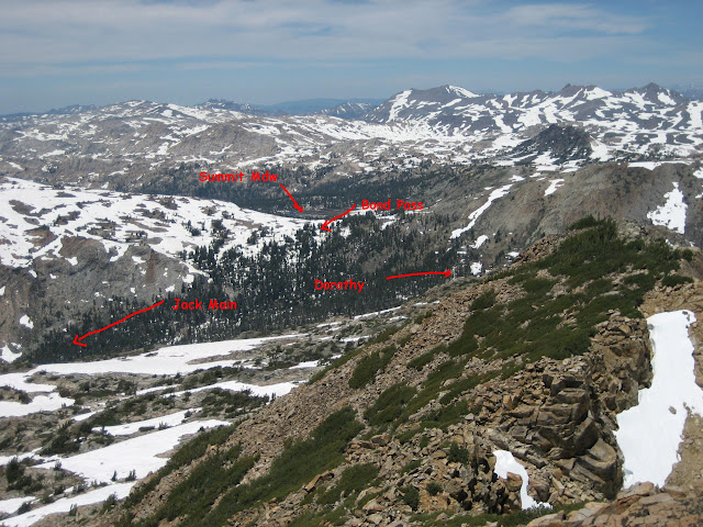
(I labeled Summit Mdw, Bond Pass, Jack Main, and where Dorothy lies)
Was up there last year in mid-Aug and I can show you that... but there wasn't a stitch of snow
in Jack Main or on Bond Pass.
Have fun
|
Re: Backpacking Hetch Hetchy in May May 14, 2011 12:50PM | Registered: 14 years ago Posts: 5 |
thanks for the quick response! I hope the scenery would be great. This would be my first time hiking in Yosemite, I wonder why this trail head and other from Hetch Hetchy are not as popular? Or is it going to fill up as the other trails from the Valley and Tuolumne are to capacity?
My idea of the wilderness is to get away from people. so hopefully I wont see too many other people there.
BTW, I dont see a trail up Forsyth, did you scramble up? What other summit would this be possible along my route to get a better view?
My idea of the wilderness is to get away from people. so hopefully I wont see too many other people there.
BTW, I dont see a trail up Forsyth, did you scramble up? What other summit would this be possible along my route to get a better view?
May 15, 2011 08:11AM | Moderator Registered: 16 years ago Posts: 1,918 |
Quote
chchan23
thanks for the quick response! I hope the scenery would be great. This would be my first time hiking in Yosemite, I wonder why this trail head and other from Hetch Hetchy are not as popular? Or is it going to fill up as the other trails from the Valley and Tuolumne are to capacity?
My idea of the wilderness is to get away from people. so hopefully I wont see too many other people there.
BTW, I dont see a trail up Forsyth, did you scramble up? What other summit would this be possible along my route to get a better view?
Not sure you saw this or not:
http://yosemitenews.info/forum/read.php?3,35489
So, yes, the scenery will be great. After you get back go back to that thread and compare it to what you saw in Jack Main.
Why isn't HH so busy? Well, IMO mainly b/c there are a large number of easier trails out of Tuolumne Meadows
and a huge number will want to hike by Half Dome or hike downhill into the Valley.
I've heard loads of people complain about the trails out of HH (except Rancheria, which is an easy backpack) but
to me it's all pretty darn sweet. And you may well second guess yourself too while you are chugging up Moraine Ridge
(4400 ft. gain from HH Dam) but if you put in the effort you will be rewarded IMO.
It's unlikely that Beehive will fill up regularly once Tioga opens. (pretty sure it seldom does)
I did the Bear Valley loop (via Rancheria Mtn) in late Sept. one year and was told by the ranger that
only one other person went to Bear Valley that way that year (from what I remember him saying)
(may well have been the only).
Anyway, as for "better" views. That's subjective. Any high peak will have a sweet view.
For your route, you could hit Bigelow along the way if you skip Summit and Horse Meadows.
It's a pretty simple peak, go to Bond Pass for a view of Summit Meadow, and then head
straight to Bigelow. From the Bigelow Saddle you can drop to Bigelow Lake and
catch a trail again, following it past Black Bear Lake to Upper Twin before heading to Huck.
Here's a picture b/t Bond and Bigelow:

Here's looking west:

With little work you'll get a nice view of Grace Meadow. And looking at a map it'll be obvious you can
see Dorothy (which you should go and touch at least) (great great views of Forsyth there), Forsyth, Keyes,
Saurian, and Tower. I'll let you wonder about those...
I'll comment a little bit about your route... b/c few, if any, do that loop. My recommendation is to go to Eleanor
via Kibbie b/c that route is far better than hiking past Shingle Springs IMO.
Probably the trail from Eleanor to Shingle is used by a scant few before April 15th and after Sept. 15th
(when you can't drive to Shingle).
Have fun
|
Re: Backpacking Hetch Hetchy in May May 15, 2011 03:13PM | Registered: 14 years ago Posts: 5 |
Awesome! I'm stoked. Yeah, I saw that thread and even now it looks amazing. I just hope that the trail would be dry or at least not under water. I will definitely take some detours along the route for some summit trip. About your recommendation on the route, I don't see a direct trail from Huckleberry Lake to Kibbie. I dont see Shingle Springs either. Though I dont want to hike through any civilization or roads other than through Elanor. Here is more or less the route that I planned-
http://www.trimbleoutdoors.com/ViewTrip/1107992
Please let me know if I should consider a different route.
The first couple of days would be rough, I think we'll probably get there some time early in the afternoon so we can tackle some of the 4000ft gain before we get tired or sunset, whichever comes first.
|
Re: Backpacking Hetch Hetchy in May May 15, 2011 03:18PM | Registered: 14 years ago Posts: 5 |
May 15, 2011 04:48PM | Moderator Registered: 16 years ago Posts: 1,918 |
Yeah, that's what I assumed your route was. Thus the words about Bigelow.
Unless you want to do cross country and that is your cup o tea then I would say
stay on the trail and do that first. Come back some other day and do xcountry
routes. The Bigelow zig I mentioned is very straightforward and can easily
be done with a pack on IMO (we did).
I mentioned Kibbie b/c it is nice and going from Styx Pass Jct. to Kibbie is
both nice and also very easy. You will have already come down Upper Kibbie Ridge
and probably had enough woods walking by then and heading into them near
Mercur (Mercur Peak is a nice one to go up too)... and the trail I mentioned will
not blow your mind.
As for other routes... you can look at the big picture map and come up with many.
They are all spectacular.
Just be very careful if you starting planning an extended xcountry route in NW Yosemite.
Have fun
|
Re: Backpacking Hetch Hetchy in May May 16, 2011 08:28PM | Registered: 14 years ago Posts: 5 |
May 25, 2011 09:01AM | Moderator Registered: 16 years ago Posts: 1,918 |
Your loop is fine. I just wanted to mention about Shingle Spring area and maybe you wantQuote
chchan23
Maybe I should consider a different loop, out of HH, more towards the east side out through Rancheria. I wouldnt want to be in the woods that much. Thanks for the tip
to head to Kibbie (which, anyone who has been there... loves loves loves) instead.
That's all. There are loads of woods in Yosemite. Almost every single trail you can think of
will have miles of walking in the woods. This is not a bad thing. It gives you some relief
from that orange ball in the sky. Even trails which people say are the best ever are lots of woods.
So don't let that dissuade you.
For Kibbie Ridge there are items here and there that I really enjoy. Go and find them...
Have fun
May 16, 2011 07:35AM | Moderator Registered: 16 years ago Posts: 1,918 |
|
Re: Backpacking Hetch Hetchy in May May 25, 2011 08:18AM | Registered: 14 years ago Posts: 11 |
Hi All –
My group and I returned about 2 weeks ago from a great trip in Hetch Hetchy. Just about all of the advice on this forum was correct and my pals and I certainly got what we were looking for: solitude and challenge! Here’s a synopsis of our trip, with some links to photos and videos at the end:
Day 1:
40deg. Full packs. We hiked up the switchbacks to Beehive and felt pretty good. My two friends and I felt strong and everything was pretty clear. After getting into beehive however we hit snow and got lost! The whole time there had been trail markers but for some reason they evaded us once we got to beehive. We’re good with the map/compass but hadn’t really set a bearing while we were on the trail because you don’t really need it of course. In the later areas of the backcountry we saws landmarks such as ravines, ridges, peaks, lakes, etc. so we generally knew were we were on a map. But in Beehive you could spin me around and it all looks the same. We post-holed a lot and the terrain was wicked challenging, with deep snow, deep falls through the snow, but hey, fun! My buddy fell through a hole near a tree and couldn’t even reach the bottom with his toes. We looked down the hole after getting him out and we couldn’t see the bottom!
So after meandering a while one of us whipped out the android GPS and saw that we had gone too far south. We headed back north to beehive, made a makeshift campsite in a sunken area between two trees and had our first night of snow camping. Temps were cold and it rained and snowed through the night but we were generally comfortable.
Day 2:
The rain had frozen and had made a nice crust upon the snowpack, so much so that walking became a lot easier. Nevertheless, we put on our snowshoes for the day and that was much better! It was lightly snowing but no big deal. What happened next was one of our biggest snafus. We set a bearing from Beehive to Vernon and set out on course, but our bearing must have been off because we snowshoed for quite a ways without seeing the lake. Turns out we had gone a little too far north and ended up going through the ravine just west of moraine ridge, along frog creek. After consulting the GPS and fixing our bearing back SE to Vernon we then hiked up and down all those aggressive ups and downs. Tiring! But great pics! We eventually got to the ridge overlooking Vernon but hadn’t gone NE enough to be able to descend peacefully, so the scrambling down was a bit precarious. Luckily there was a lot of brush to aid in the descent.
Once we got down we were really tired but able to make a decent campsite amidst the granite. The temp that evening must have been around 20deg before you factor in the 50mph winds through that valley. We made a hot dinner, skipped a campfire and got into our 3-person tent. The winds were so strong that night that our tent would’ve likely blown away if it were not for us laying in it!
Day 3:
I had originally planned to go further than Vernon, to either just explore or day-hike from the lake. But after the first two days we realized that the risk for getting lost was high and the time we needed to estimate for navigation was large. So we didn’t do much non-“goal-oriented” travelling. This is actually my one regret from the trip, because we ended up finishing 2 days early due to this temperament.
We set out around Vernon, crossed the bridge, and headed back north a bit to begin ascending Mt Gibson at the gentler grade. Although the snow was still quite deep, we could slightly see the rock formations that outlined the switchbacks on the trail. However, once we got over the first big hump the trail was gone again and we were faced with the precarious task of getting around the Mt correctly; if we were off slightly in either direction we’d be faced with non-descendable grades. We did a lot of bush-whacking and the course was challenging, but it was so fun! At one point we crowned a ridge and found ourselves in a mini-valley just SW of the peak. We termed this area “bear paradise” because it was a really delightful cove with streams and relatively gentle grades, and the bear tracks were too numerous to count! After changing our bearing back SE like the trail map suggested, we continued around the Mt and had a grand view into the TilTill creek and valley. We were a little worried about how to get down, and the thought of spending the night on the Mt was looming near, but then we eventually stumbled upon the trail! What a sight of jubilation I can say! That got us safely down to the gorgeous valley and to a pre-made campsite, awaiting us with a fire ring and even chopped wood! We were so happy that night that we all ate double portions of our food and made a large, fragrant campfire. About eight or so deer kept running down the trail near our campsite, and continued to hang around after dark. You could see their eyes reflecting back at you out of the woods when we faced our headlamps toward them. A little spooky I must say.
Day 4:
We made a leisurely breakfast: campsite flapjacks! After setting out on the trail we eventually had to cross the valley and water was standing between one and three feet deep. We were able to hop across on stones pretty well since we all had poles and waterproof boots, but some points were inevitably deep so we resorted to the “running fast” tactic. It works damn well! The rest of the way to Rancheria falls was pretty but fairly unremarkable given that trails seemed boring to us now. My face and neck were also sun-burnt so my energy was lacking. We spent lunch at the falls and even took brief naps at the base near the water. We had planned to spend one more night near the footbridge but quickly realized that there were no good campsites on the edge of the no-camping zone. It was about 3:30pm so we decided to hoof it back to the dam, skipping our last night on the trail. We moved real fast and got in to the backpackers campsite before dark. At the lodge we got a couple rounds of beer in us as well before bed; quite a good reward!
Conclusion & Lessons Learned:
Hetch Hetchy backcountry in May is very challenging. But as long as you know what you’re getting into and are prepared for the conditions then it is very rewarding; both for the challenge and the solitude. (We saw no one until coming into Rancheria Falls on Day 4.) In hindsight I would’ve brought a dedicated GPS as a backup to the map and compass, because it’s easy to get lost off trail. I also would like to try going ultra-light next time, as I always come back from backpacking trips thinking I should’ve taken less items and less food, although, there was one night where I was wearing all of my clothing to stay warm! To all those in this forum who gave me practical advice on what to expect, thank you, it was a great trip with my two pals and I'd recommend it.
Photos: http://maxyosemite2011.shutterfly.com/pictures/8
Videos: htttp://www.youtube.com/watch?v=qjVY0SPJdKc&playnext=1&list=PL4D387E55CBEF32DA
May 25, 2011 09:15AM | Moderator Registered: 16 years ago Posts: 1,918 |
Thanks. That's too bad you didn't get into Jack Main... although I figured it might
not occur... and if it did you might come back and say "wtf were you getting us into!".
You'll have to come back another time and go for it without the snow.
Glad you had a good time regardless.
In case you never saw them you may be interested in these
since you have now been some of these places:
http://yosemitenews.info/forum/read.php?3,35489
and here is Vernon in December:
http://yosemitenews.info/forum/read.php?3,30771
May 25, 2011 12:03PM | Registered: 16 years ago Posts: 1,882 |
|
Re: Backpacking Hetch Hetchy in May June 02, 2011 08:32AM | Registered: 14 years ago Posts: 7 |
my group and i (6 total) just returned from the lake vernon loop as well except we did it counter-clockwise.
day 1 (5/26): big breakfast, late start. found a great campsite at rancheria falls. slept under the stars.
day 2: hiked to tilltill creek. lots of downed trees to climb over and tilltill valley very wet. we removed our boots and went to sandals and shorts to traverse about a hundred yards of sawmp that was about a foot deep. we crossed tilltill creek over downed logs and found a great campsite looking west down a meadow with 8-9 deer grazing and playing. started the night out sleeping outside but clouds came in and we decided to go to the tents. didnt want wet bags in vernon. a couple of my friends saw a bear in the meadow the next morning. too far away to identify.
day 3: we split into 2 groups of 3 with 1 group heading back and the other group going up the switchbacks up mount gibson toward lake vernon. didnt see nearly as much snow as we thought we would, presumably b/c we were on the south side of gibson. however, once we reached 7200 feet we started seeing snow and lost the trail. the snow was still firm so we didnt need snowshoes until about 7500'. as soon as put them on it began snowing and soon turned into very heavy snowfall, limiting visibility. we had gps, map & compass but it was hard to maintain a bearing due to low visibility. as a result, we didnt exactly take a straight shot across gibson. probably added another half to one mile to our journey. our first tiem snow shoeing and it was pretty damn fun, except going down some steep parts, somersaulting down most of the time. we figured out eventually that backwards works well going downhill.
we found the trail once we reached the overlook down to the lake. however, the switchbacks were covered with snow and decided just to hike down the dry granite on the northwest side of gibson. found a nice spot and set up camp for the night. while we were getting water we saw two people across the footbridge in shorts. i dont think they saw us as were kneeling down with our bladders/filter. we also saw a yellow tent across the lake. more people than i expected, that's for sure. weather alternated btwn snow and hail until we went to bed.
day 4: we woke up and there was snow everywhere. trees and and morraine ridge that were bare were now covered in snow. we got at least 4 inches. lost the trail almost immediately after crossing the foot bridge and resorted to the topo to guide us up and out of vernon. tons of snow but firm so no snow shoes needed. some postholing but not too bad. skies were gray anfd cloudy all day but every once in a while we would get some blue skies in the duistance and that was great for morale. snowed heavily again limiting visibility. pciked up the trail again after beehive meadow. actually we picked up footprints that led us to the trail. ran into a couple day hikers and a guy looking foir his wolf, Milo. came down the switchbacks with a vengeance, skippinng lunch.
all in all, we were probasbly off the trail for 8-10 miles and snowshoed for 2-3. met up with our friends and celebrated our amazing journey.
June 02, 2011 01:47PM | Registered: 15 years ago Posts: 7,421 |
Really appreciate that you came back and said what you did.
A couple of comments:
- You didn't see much snow out of Tiltill b/c of the angle of the sun in the sky. That is classic south facing slope losing snow much earlier than north facing.
Not sure you looked at the photos I posted about Jack Main... but you could see that the trail was clear weeks ago in those photos.
This is very typical. In lower snow year you would get nearly the same. Snow at top of Gibson almost always persists thru Memorial Day.
Perhaps you coud not see in the photos b/c you aren't super familiar with the trails and whatnot.
- "a couple of my friends saw a bear in the meadow the next morning. too far away to identify". Chuckling a little about this.
You already identified it. It's a bear. Yosemite only has Black bears.
Glad you had fun
June 02, 2011 02:50PM | Registered: 14 years ago Posts: 424 |
Sorry, only registered users may post in this forum.

