Hi,
I'm a newbie to this site, but I figure if anyone can give me some info and advice, it will be someone here. If I can manage to snag a permit, I’m planning to do an overnighter this weekend, going up the Snow Creek Falls trail, traversing over to Yosemite Falls and coming down that trail. Although I’ve been up both of these trails before, I’ve never connected the two, and certainly haven’t tried to do this when there is snow (I’m assuming that a good part of this connection will be completely under snow). So my question to anyone who might have done this in winter – is this going to be a route-finding nightmare, and am I likely to encounter any impassible situations (like raging streams) trying to attempt this?
Thanks!
John

The Moon is Waning Gibbous (67% of Full)

Re: Snow Creek to Yosemite Falls Info?
All posts are those of the individual authors and the owner
of this site does not endorse them. Content should be considered opinion
and not fact until verified independently.
|
Snow Creek to Yosemite Falls Info? May 25, 2011 02:45PM | Registered: 14 years ago Posts: 5 |
May 25, 2011 04:39PM | Registered: 15 years ago Posts: 7,421 |
It's not winter anymore. In winter Indian Canyon Creek crossing is snow bridged if I remember
correctly. Lehemite has logs... so it is non-issue imo year-round.
You may like these:
http://yosemitenews.info/forum/read.php?3,29866,29867#msg-29867
This is applicable to what you ask:
http://yosemitenews.info/forum/read.php?3,33697,33727#msg-33727
Most of the rim will not be an issue locating the trail. (def. not the case on Pohono)
You can skip Lehemite Crossing if you skip Indian Ridge and North Dome.
Since you have gone up both before you know what you are getting into.
Expect snow beyond the bridge. That is what they will tell you at the wilderness center.
Indian Canyon Creek was roaring last weekend (spied it from Pohono).
If you lose the trail entirely (you probably will.. ) then head up. With map and your noggin
you should be able to figure it out. Worse case come back down and follow Snow Creek
back down and nix it.
When you get the permit they MAY know more info. I never go back and report conditions
which is frequently how they get trail conditions... maybe many actually do.. ???
I'll try to find a picture for you tonight of the south rim from GP.
Here's one:
http://yosemitenews.info/forum/read.php?3,29227,36628#msg-36628
Also found this:
http://yosemitenews.info/forum/read.php?1,3181,3181#msg-3181
Haven't seen this thread...
I'd like to meet this Mike guy that says everything is "cake" and "easy".
(and tell him that he is the reason I waste so much time on this #$%A! forum)

If there is a lot of snow that route would be much easier actually than here:
http://yosemitenews.info/forum/read.php?3,29798,29798#msg-29798
Give your trip a go. The days are long and it's great hiking weather.
Don't blame me though if the snow becomes too much
And my apologies if someone actually comes along and says "I just did that... it was easy"
Probably WTMI here... blah blah blah
Have fun

correctly. Lehemite has logs... so it is non-issue imo year-round.
You may like these:
http://yosemitenews.info/forum/read.php?3,29866,29867#msg-29867
This is applicable to what you ask:
http://yosemitenews.info/forum/read.php?3,33697,33727#msg-33727
Most of the rim will not be an issue locating the trail. (def. not the case on Pohono)
You can skip Lehemite Crossing if you skip Indian Ridge and North Dome.
Since you have gone up both before you know what you are getting into.
Expect snow beyond the bridge. That is what they will tell you at the wilderness center.
Indian Canyon Creek was roaring last weekend (spied it from Pohono).
If you lose the trail entirely (you probably will.. ) then head up. With map and your noggin
you should be able to figure it out. Worse case come back down and follow Snow Creek
back down and nix it.
When you get the permit they MAY know more info. I never go back and report conditions
which is frequently how they get trail conditions... maybe many actually do.. ???
I'll try to find a picture for you tonight of the south rim from GP.
Here's one:
http://yosemitenews.info/forum/read.php?3,29227,36628#msg-36628
Also found this:
http://yosemitenews.info/forum/read.php?1,3181,3181#msg-3181
Haven't seen this thread...
I'd like to meet this Mike guy that says everything is "cake" and "easy".
(and tell him that he is the reason I waste so much time on this #$%A! forum)
If there is a lot of snow that route would be much easier actually than here:
http://yosemitenews.info/forum/read.php?3,29798,29798#msg-29798
Give your trip a go. The days are long and it's great hiking weather.
Don't blame me though if the snow becomes too much
And my apologies if someone actually comes along and says "I just did that... it was easy"
Probably WTMI here... blah blah blah
Have fun
May 25, 2011 04:45PM | Registered: 15 years ago Posts: 7,421 |
O criminy.
My words o wisdom are:
- Map and Compass (since I get slammed every time I say I don't bring them... )
- GPS (then route finding... unless you are testing yourself and not using it... is not an issue)
(or you don't know how to use it)
I have not crossed Indian Canyon Creek when it is roaring. I have heard some people
say it was difficult. I have not heard people being turned around by it though.
If I was concerned about it... I would go up Yose Falls instead and be prepared to turn around...
or I would be prepared to take the time to hike upstream a very very long way to
cross it safely.
My 12 dollars worth
|
Re: Snow Creek to Yosemite Falls Info? May 26, 2011 08:36AM | Registered: 14 years ago Posts: 5 |
Chick-on, thanks! Your photos are fantastic. And useful.
So now you've got me worried about Indian Creek. My plan is to go up Snow Creek on Saturday, and meet up with family and friends at the top of Yosemite Falls trail on Sunday, so I'm kind of stuck with starting up Snow Creek. Hopefully I'll find a crossing spot somewhere up the creek - I'm pretty patient.
Thanks again for the info and the links!
John
May 26, 2011 09:23AM | Registered: 15 years ago Posts: 7,421 |
If you're in really good shape you could find out on Saturday... it's "only" about 10 miles the quickest
way on trail to Indian Canyon Creek via Snow Creek.
Expect to hit lots of snow. You're call on whether to bring snowshoes. (I would just take the darn things)
I put two photos here taken from Sentinel Dome on Sat:
https://picasaweb.google.com/yosemite.chick.on/Pohono#5610847311126913122
https://picasaweb.google.com/yosemite.chick.on/Pohono#5610847315558193826
Not sure they help much since there won't be that much or if you can make out stuff in it.
Sorry about the worry. Just haven't done it really early so... dunno...
It so forested b/t Yose Pt. and Indian Ridge that there is no way there aren't logs across it...
I sorta see one in one picture I took b/t the trail and the drop into IC... but not sure..
Was gonna go up Indian Canyon to see top of Royal Arch Cascade a couple weeks
ago but was told I should stay home some weekends... Kinda wanted to see it firsthand.
Anyway, have fun whatever you end up doing
|
Re: Snow Creek to Yosemite Falls Info? June 02, 2011 03:58PM | Registered: 14 years ago Posts: 5 |
Well, Memorial Day has come and gone, so I thought I'd thank Chick-On for the info he gave me, and provide a short TR on the Snow Creek to Yosemite Falls "trail".
I left Curry Village around 5PM after the rain stopped for a bit (long story, but I was camping with relatives and had to spend the early part of the day hiking with everyone). By the time I reached the Snow Creek trail and headed up, it had started raining again. The trail was snow-free until I reached the rim, but there was plenty of snow at the rim. I picked a snow-free spot a bit before I reached the Snow Creek bridge, and got my tent up right as a snowstorm hit. So, as of Sunday morning, the rim was completely snow-covered (about an inch fell overnight).
Finding out that I'm in worse shape than I thought, I skipped the climb up to Indian Ridge and went around on the north. Lots and lots of snow up there. Coming around and heading for Yosemite Falls, sure enough, Indian Creek was raging. I ended up going upstream about half an hour before I found a nice, big fallen log that I could cross easily. The steep slopes down to the creek make it a challenge to get down to the water, and on the far side, huge snow drifts cut off a few earlier potential crossings. After this it was clear sailing all the way to the Yosemite Falls bridge. Snow cover started to break up around Yosemite Point.
I didn't see anyone as I hiked up Saturday evening, and it wasn't until after I crossed Indian Creek that I finally encountered other parties hiking in from Yosemite Falls.
I'm looking forward to doing this again when there is no snow (and when I'm in better shape)!
|
Re: Snow Creek to Yosemite Falls Info? June 02, 2011 05:49PM | Registered: 14 years ago Posts: 79 |
do you have any photos? will be on that section of "trail" for the first time in a couple weeks -- heading n.e. toward tenaya lake. how was the snow for walking on? without a gps, will i have a hard time staying on course? since my loop will consist of clockwise around the valley (rockslides-yosfalls-snow creek-tenaya lake-clouds-halfdome-happyvalley) i can't imagine getting lost with the valley and all the landmarks to reference for navigation (in addition to map/compass). any advice?
June 02, 2011 09:43PM | Registered: 15 years ago Posts: 7,421 |
June 03, 2011 06:18PM | Registered: 15 years ago Posts: 7,421 |
You may get a kick out of this set:Quote
SUMBO
huge snow drifts cut off a few earlier potential crossings
https://picasaweb.google.com/yosemite.chick.on/MercedGroveTwinBridges
A couple of goofy ways to cross a creek and not get your flippers wet.
(when no bridge, snow or otherwise, is avail)
June 03, 2011 07:51PM | Registered: 14 years ago Posts: 424 |
Quote
chick-on
You may get a kick out of this set:Quote
SUMBO
huge snow drifts cut off a few earlier potential crossings
https://picasaweb.google.com/yosemite.chick.on/MercedGroveTwinBridges
A couple of goofy ways to cross a creek and not get your flippers wet.
(when no bridge, snow or otherwise, is avail)
Awesome pics. Definitely enjoyed looking at those.
|
Re: Snow Creek to Yosemite Falls Info? June 03, 2011 09:52AM | Registered: 14 years ago Posts: 5 |
Hi MTC,
I'm kind of embarrassed to admit this, but I can't figure out how to post pictures. I do have a few - I'll try to add them this weekend. Concerning the snow, I brought snowshoes and used them for a stretch, but I think I would have been fine without them. For the most part, I was only sinking in maybe 4 inches max without the snowshoes.
Can you do your planned route without a GPS? I'm a route-finding nightmare, so I always carry GPS, map, and compass, and then I manage to get lost at least once. So I'm probably not a good one for advice. I did your planned route a couple of years back at Thanksgiving, when there wasn't much snow on the ground, and I recall that there are a number of stretches where you don't have good landmarks to check against. Others may be able to help you more with this. By the way, that's a fantastic route. When I did it, I camped on Mt Watkins the first night, then hiked to Olmstead (beautiful when 120 has already been closed), over to Clouds Rest (in a snowstorm - seems to happen to me a lot), and then camped near the intersection with the Half Dome trail. No Half Dome - not after the previous day's storm. But it was really pretty.
Chick-on, I only mentioned the time because I was thinking to myself that it was a bit foolish to START this trip at 5PM, when I knew I needed to reach the rim at least before I could set up camp. A funny thing here - the next day my wife was heading up to meet me, and a ranger told her I couldn't have gone up the Snow Creek trail because it was closed. She told the ranger I had a permit, and he explained that they closed the trail AFTER they had given out permits that morning. Funny, because I saw no "trail closed" signs, and certainly no indications of problems with the trail as I went up.
June 03, 2011 10:27AM | Registered: 15 years ago Posts: 7,421 |
Sorry. I just assumed that you took your sweet old time and nixed Indian Ridge.
But I guess that was due to saying "no mas" after hitting the saddle and it
was alot of downhill from there instead of continuing up to Indian Arch/Ridge, etc.
I do the same stuff frequently. Wanna go here and here and there and there...
get out there and say "uh... this is good".
That is wierd they "closed" Snow Creek. Doesn't make much sense since it's
open in winter. Interesting you say you did loop during Thanksgiving.
Purty kewl. Hiked to TM and past Cathedral mid Nov. ahh...
As for route finding... if it's full snow it's pretty easy to get off line. So much is
in woods and it doesn't take much to lose the trail. But, yes, with so many
landmarks.... just head in a direction and imo, if you have a sense of direction,
you should be able to figure it out. Worse case hike your butt due north and
follow the blacktop...
Good luck
|
Re: Snow Creek to Yosemite Falls Info? June 03, 2011 03:48PM | Registered: 14 years ago Posts: 79 |
thanks, both of you. i'm a little pre-disappointed that i'll be facing snow covered granite and woodland up there as this is my first trip to the yosemite backcountry. however, i'm sure i'll get over it -- no matter what the weather/conditions, it will surely be infinitely better than the boring landscape and humid 95deg we have here in southern indiana already this spring. do you guys think tenaya and mildred will still be iced over two weeks from now? what should i expect from the tenaya lake outlet crossing (besides cold kahunas)?
June 03, 2011 06:07PM | Registered: 15 years ago Posts: 7,421 |
Tenaya will look at least like this, probably more covered:

If you're lucky the crossing will only look like this:

I'd have neoprene socks with me for that crossing.... or not do it...
You list your exp. as "Advanced". That is good. It's possible you are biting off more than you can chew.
Mildred will undooobadably still be nearly completely frozen over still in two weeks as will
all of the Sunrise Lakes. Not sure where you got to go to Mildred. Maybe you want to hike up Tenaya Peak?
But. My guess is that you will skip that. I'd expect 100% snow coverage up there and I would
recommend if you really want to check out frozen lakes to go to 1st and 3rd Sunrise.
Mildred does have some spectacular views down canyon but the steepness of the approach to and fro
may have you second guessing your decision.
I'd also guess that you'll be a jumping onto the road and hiking it once you get near Olmsted.
Hopefully you don't freeze your dingle balls off in Tenaya Creek or run into an iceberg...
Whatever you end up doing it should be fun.
Found this pict. of Conness taken from Tenaya Peak when hiked to Mildred area that others may get a kick out of:
The view from Tenaya Peak is spectacular... would def. be cool to see in winter or even with Tenaya mostly frozen now.
Have fun
If you're lucky the crossing will only look like this:
I'd have neoprene socks with me for that crossing.... or not do it...
You list your exp. as "Advanced". That is good. It's possible you are biting off more than you can chew.
Mildred will undooobadably still be nearly completely frozen over still in two weeks as will
all of the Sunrise Lakes. Not sure where you got to go to Mildred. Maybe you want to hike up Tenaya Peak?
But. My guess is that you will skip that. I'd expect 100% snow coverage up there and I would
recommend if you really want to check out frozen lakes to go to 1st and 3rd Sunrise.
Mildred does have some spectacular views down canyon but the steepness of the approach to and fro
may have you second guessing your decision.
I'd also guess that you'll be a jumping onto the road and hiking it once you get near Olmsted.
Hopefully you don't freeze your dingle balls off in Tenaya Creek or run into an iceberg...
Whatever you end up doing it should be fun.
Found this pict. of Conness taken from Tenaya Peak when hiked to Mildred area that others may get a kick out of:
The view from Tenaya Peak is spectacular... would def. be cool to see in winter or even with Tenaya mostly frozen now.
Have fun
|
Re: Snow Creek to Yosemite Falls Info? June 03, 2011 07:50PM | Registered: 14 years ago Posts: 79 |
thanks chick-on,
i must admit that i've never hiked over 10ft of snowpack -- however i am fit, ambitious and pretty confident in my abilities and gear (as is my studly 18 yr old son who'll be accompanying me). shame about the ice cover on mildred and sunrises. oh well, i'm sure it will still be a beautiful and challenging adventure. next year, i'll schedule into july to be in better position to avoid the snowpack and ice cover. the trip was concieved and insprired by photos and trip reports of sunlight, water (liquid) and granite -- but like i said, snowpack or rain, still really excited about the adventure!!!!
i must admit that i've never hiked over 10ft of snowpack -- however i am fit, ambitious and pretty confident in my abilities and gear (as is my studly 18 yr old son who'll be accompanying me). shame about the ice cover on mildred and sunrises. oh well, i'm sure it will still be a beautiful and challenging adventure. next year, i'll schedule into july to be in better position to avoid the snowpack and ice cover. the trip was concieved and insprired by photos and trip reports of sunlight, water (liquid) and granite -- but like i said, snowpack or rain, still really excited about the adventure!!!!
June 03, 2011 08:22PM | Registered: 14 years ago Posts: 1,351 |
June 03, 2011 08:45PM | Registered: 15 years ago Posts: 7,421 |
10 ft. or 3 ft. it won't matter. You'll have a blast.
For next year you probably want to do late July to be safe.
Even 4th of July last year a number of higher elevation lakes were frozen over.
If you have not seen these two sets they will give you an idea:
Matthes set was June 19-20, 2010
Parker-Donahue was July 2-6, 2010
https://picasaweb.google.com/yosemite.chick.on/Matthes
https://picasaweb.google.com/yosemite.chick.on/ParkerDonahue
Matthes has Upper and Lower Cathedral shots in it. Thus my statement about Mildred, etc.
If you have the desire and gumption you can do it. So I'm confident you will from what you have said.
Take a bunch of pictures
|
Re: Snow Creek to Yosemite Falls Info? June 07, 2011 06:16PM | Registered: 14 years ago Posts: 79 |
June 07, 2011 06:51PM | Registered: 15 years ago Posts: 7,421 |
June 07, 2011 06:57PM | Moderator Registered: 16 years ago Posts: 1,876 |
Quote
chick-on
Don't worry. The sun will be here soon. Summer is only 8 days away!
Hey! Chikin! You're not on your home planet anymore!
(Earthily Yours)
The Marmots
P.S. Marmots are from Venus. Chikins are from Mars.
THE YOSEMITE POST
Voice of the Rocky Marmot Empire
Edited 1 time(s). Last edit at 06/07/2011 07:03PM by szalkowski.
June 08, 2011 06:19PM | Registered: 14 years ago Posts: 456 |
June 08, 2011 07:18PM | Registered: 15 years ago Posts: 7,421 |
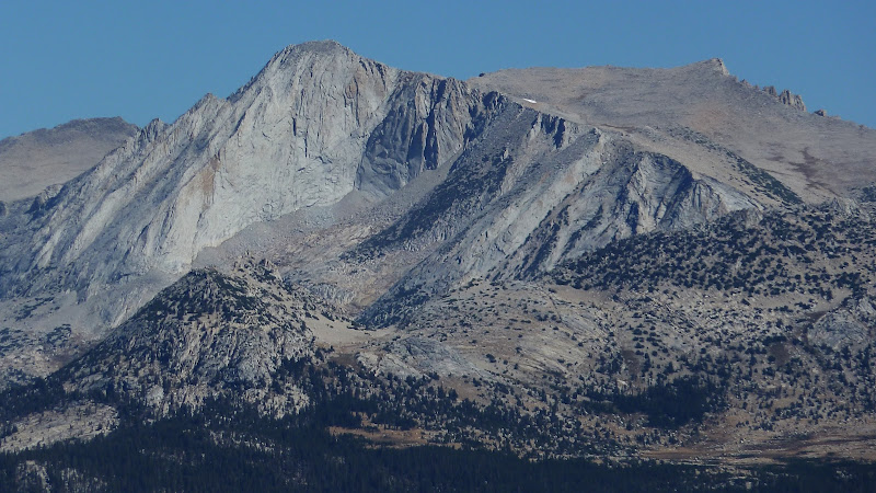
It's not named. The big "flat" area is the Plateau south of Conness and the peak you pointed out isQuote
mbear
chick-on, what's the name of that peak to the right of Conness in that pic? Or is it even named?
only a bit less than 300 ft. lower than the summit of Conness.
Here's a map: (the blue is the use trail from Youngs) (which used to be a "real" trail)

On the bottom of the Map is White Mountain:
https://picasaweb.google.com/yosemite.chick.on/Peakies#5381547890280378994
(Billy didn't let me go up Conness with him.. )

June 08, 2011 07:33PM | Registered: 14 years ago Posts: 456 |
Sorry, only registered users may post in this forum.

