Welcome! Log In Create A New Profile Recent Posts
Dogwood bloom in Yosemite Valley

The Moon is Waxing Gibbous (61% of Full)


Advanced

Re: Mt. Clark

All posts are those of the individual authors and the owner of this site does not endorse them. Content should be considered opinion and not fact until verified independently.

avatar Mt. Clark
August 08, 2011 05:46PM
Had fun backpacking with The Old Dude. Hiked up Mt. Clark via NW Face->NW Arete. Came down NW Arete->NE Face.
Lots of great open areas and domage between Starr King area and Clark.

Set of photos with maps here:
https://picasaweb.google.com/yosemite.chick.on/MtClark

Here's a few from the set:

Atop Summit w/ a Pink Summit Twinkie:


Looking down: smiling smiley


Looking at Clark from Clark Canyon:


NW Arete:


Mt. Starr King:


Enjoy


Chick-on is looking at you!
avatar Re: Mt. Clark
August 08, 2011 06:16PM
Thanks for all the photos. Looked like it was a spectacular trip.


I have a question about this photo: what is the name of this dome or mountain? (I might be having a brain fart, but I can't readily recognize it)

avatar Re: Mt. Clark
August 08, 2011 06:17PM
You'd probably figure it out from the other side.
avatar Re: Mt. Clark
August 08, 2011 06:24PM
Quote
eeek
You'd probably figure it out from the other side.

Which other side?
(NWerly Yours)
The Marmots


Edited 1 time(s). Last edit at 08/08/2011 06:32PM by szalkowski.
avatar Re: Mt. Clark
August 08, 2011 06:43PM
Quote
szalkowski
Quote
eeek
You'd probably figure it out from the other side.

Which other side?
(NWerly Yours)
The Marmots

The other other side of course.
avatar Re: Mt. Clark
August 08, 2011 06:24PM
Quote
eeek
You'd probably figure it out from the other side.

I'm tempted to say it's the backside of Half Dome, but I would of thought I would see either Mt. Hoffman or Mt. Conness in the distance, or some other peaks further in the background.


Edited 1 time(s). Last edit at 08/08/2011 06:27PM by plawrence.
avatar Re: Mt. Clark
August 08, 2011 07:18PM
Perhaps I can tempt you to take another look just to the left of that dome.

Ok, I just tell you... that's Yosemite Pt. And in the shadow there is Upper Yosemite Falls.

This shot was taken on top of the ridge just west of Lake WL9235.
(the ridge is v. similar to Horse and Buena Vista Crest)


Chick-on is looking at you!
avatar Re: Mt. Clark
August 09, 2011 11:27AM
Quote
chick-on

Ok, I just tell you... that's Yosemite Pt. And in the shadow there is Upper Yosemite Falls.

This shot was taken on top of the ridge just west of Lake WL9235.
(the ridge is v. similar to Horse and Buena Vista Crest)

Thanks for the info.

When I first looked at the photo, I thought what is actually Yosemite Point was just an extension or a shoulder of the dome itself, so that threw me off. And Upper Yosemite Fall in the shadow just looked like a light colored piece of freshly exposed granite. I didn't recognize it as a waterfall. I'm still a bit puzzled that I can't see any landscape features beyond "El Cap Ridge". Was the sky beyond El Cap Ridge smoky or hazy that day?
avatar Re: Mt. Clark
August 09, 2011 04:02PM
Quote
plawrence
When I first looked at the photo, I thought what is actually Yosemite Point was just an extension or a shoulder of the dome itself, so that threw me off. And Upper Yosemite Fall in the shadow just looked like a light colored piece of freshly exposed granite. I didn't recognize it as a waterfall. I'm still a bit puzzled that I can't see any landscape features beyond "El Cap Ridge". Was the sky beyond El Cap Ridge smoky or hazy that day?
Sure there was smoke in the air from the Avalanche Fire... but regardless, you wouldn't see much definition...
just maybe Turlock... (this view is predominately WNW... so think about what you can see in that direction
from atop Sentinel Dome... and that is your answer) (hint: the answer is trees / rolling hills)


Chick-on is looking at you!
avatar Re: Mt. Clark
August 08, 2011 07:23PM
What you see in the distance is "El Cap Ridge" mostly.
The dome that is sticking up above the trees in the right upper is Flat BM 8944.

In the middle of the subdome heading upper right is Indian Ridge.


Chick-on is looking at you!
Re: Mt. Clark
August 09, 2011 10:17AM
That's Half Dome, awright. I see the white stripe where everyone walks up that top ridge.

I like that bump in your cheek - is that your tongue?
Re: Mt. Clark
August 08, 2011 07:27PM
I live my Yosemite life "Vicariously" through the chick-on's photo's!Chick-on is looking at you!
Re: Mt. Clark
August 08, 2011 10:13PM
Great pictures! Thanks for sharing, as always!

Quick question: while in the area, did you happen to notice any signs of the old cavalry route that (supposedly) traversed around Mt. Clark to the north? I've read that people have stumbled upon old blazes while climbing Clark from the west, and I think my wife and I found a segment of it while climbing to Obelisk Lake from Merced Lake years ago.


Edited 1 time(s). Last edit at 08/10/2011 07:03AM by basilbop.
avatar Re: Mt. Clark
August 09, 2011 07:36AM
Quote
basilbop
while in the area, did you happen to notice any signs of the old calvary route that (supposedly) traversed around Mt. Clark to the north? I've read that people have stumbled upon old blazes while climbing Clark from the west, and I think my wife and I found a segment of it while climbing to Obelisk Lake from Merced Lake years ago.
From the west? Hmm... well, IMO THE best way from the west is the way I went. Stay on ridges..
From the map it appears the trail was even further north of there.
Been around Starr King Lake/Meadow/Domage 3 times now... and haven't seen any signs of trail.
Haven't seen anything in Clark Canyon either. (wasn't really looking though the previous time)
Was looking for signs of the trail as went to Clark... but never saw anything that struck my eye.
There also used to be a trail up to Starr King Lake and Meadow from LYV.
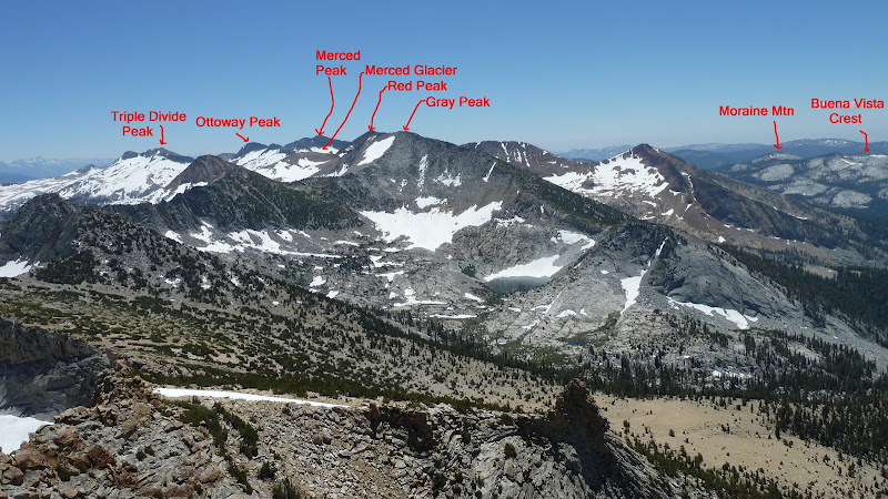
By 1929 the Mt. Clark trail was "taken off the maps". Looking at maps it never went to Obelisk Lake and went quite north
(going between Quartzite Peak and Peak 9804 to drop into Clark Canyon).
So I think if someone says they followed the Old Cavalry Trail to Obelisk Lake I would question it.
(I could be wrong) (need to go find that backpacker magazine now)
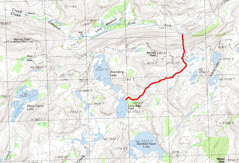
Here's the map (stays FAR away from Ob Lake) :


Anyway, have fun... I'll let you know if I ever find the trail (may be v. soon)


Chick-on is looking at you!
Re: Mt. Clark
August 09, 2011 02:22PM
The place where we thought we crossed an old trail (and it could have been a game trail, or a climber's route, or...) was near the saddle to the east of Quartzite Peak. This looks to be south of where the historical maps show the trail as having been. There were also signs of a path/trail descending the Obelisk outlet into Grey Peak fork. In the wooded slot to the west of where Grey Peak fork drops into the Merced there were a few places that looked trail-like. All-in-all, nothing definitive, but about what you'd expect for a "trail" that was probably at best a series of blazes and an infrequently-trodden path 100 or so years ago.

I agree that the cavalry trail probably never went to Obelisk (despite the Backpacker Magazine article). Secor claims that there was a route went to Adair lake and crossed the Clark Range north of Grey Peak, but I haven't seen this on any map.
avatar Re: Mt. Clark
August 09, 2011 03:39PM
Adair is one of the 6 named lakes I have left to touch in Yose...
been contemplating for quite some time how to attack it
(from Red Peak Pass Trail, Up and Over Gray Peak, up Gray Peak Fork, from Obelisk)
So I may go there very soon... although now I want to try to search for the trail into Clark Canyon...

(for you Google Earth fans... take a look west of Grayling Lake for a Plane)

Thanks for the links... now don't need to find my old BP Magazine
(following the link.. some crazy guy went directly up from ML HSC)
(he must have wings) wink


Chick-on is looking at you!
Re: Mt. Clark
August 09, 2011 05:12PM
The route to Obelisk directly from Merced Lake isn't too bad... (I'd post pictures, but they are mostly underexposed slides--bad meter...) There is (or was) a log jam just upstream from their water intake that allows for crossing the river, then it's maybe 45-degree granite slabs to treeline, and easy going past there. I've been told by camp workers that people trying to get to Obelisk often accidentally end up at Adair. There's also a good place to ford the Merced at the upper end of "Ranger Station" valley, but the route up Grey Peak Fork (which follows the obvious tree-lined crack to the west of the cascades) is choked with brush and deadfalls in places.
avatar Re: Mt. Clark
August 24, 2011 05:14PM
Quote
chick-on
Adair is one of the 6 named lakes I have left to touch in Yose...

Awesome accomplishment and that's some amazing terrain to cover and I'm jealous of how much more you've seen in the backcountry!

Out of curiousity are you counting lakes that have a name (such as Mercur Lake, which I know you've been to) but aren't named on the official map?

After you knock those 6 out, are you going to do the same feat in the Emigrant?

EDIT: what are the other 5 you have left?


Edited 1 time(s). Last edit at 08/24/2011 05:15PM by oakroscoe.
avatar Re: Mt. Clark
August 24, 2011 07:34PM
Quote
oakroscoe
Out of curiousity are you counting lakes that have a name (such as Mercur Lake, which I know you've been to) but aren't named on the official map?

After you knock those 6 out, are you going to do the same feat in the Emigrant?

what are the other 5 you have left?
Now if I'm in an area and there is a WL lake and I'm not too lazy... I hit those too... so eventually... I'll try to hit every single WL lake too...
There really are some nice unnamed lakes out there. But the baseline was the named ones on USGS map.

Emigrant. Yeah... the thought crossed my mind. Only been to about 16 of those.

The named ones in Yose I have left are:
Adair
Shamrock
Shepherd
Windy
Hoover
Inferno

Haven't been trying very hard to knock them off lately... too much other stuff been goofing on...
went by some new ones last weekend... but no new named ones...

Have fun


Chick-on is looking at you!
avatar Re: Mt. Clark
August 25, 2011 10:47AM
I'm shocked that I've seen a lake you haven't! Last year we went into many island, cut across to spotted fawn, went by little bear and stayed at boundary. One of the days we dayhiked up to inferno, which as you know gets very little traffic. It wasn't too bad to get to, but it seemed like it was all uphill. We cut up too early and created more work for ourselves. If you go on the trail by the east side of little bear while you're working towards spotted fawn the best route we found was following the trickle that feeds into little bear. It's been used before and there's a few half-assed cairns to mark the way. That's another place in the park where if you want some solitude, you'll probably get if. I remember right, the upper lake is somewhat steep around it and having no camp sites close to the lake. I can't remember on the lower one, but there might be something on the south side next to the drainage going into spotted fawn.

I'm heading out after work to go do the most traveled area in the heart the Emigrant...
avatar Re: Mt. Clark
August 25, 2011 01:58PM
I was gonna put a comment on Inferno... figured you had been there...
I know what you are talking about... went this way once coming back from Huck:

may have been to 8066... but not certain... didn't carry a GPS all the time until a few years ago.
There's a snow survey marker on this route... I presume they took down this pole too like the others on
Kibbie Ridge and Beehive and...

Have fun


Chick-on is looking at you!
Re: Mt. Clark
August 08, 2011 10:35PM
Cool photos, Starr King looks like you could just walk up it fronm that shot
avatar Re: Mt. Clark
August 09, 2011 07:20AM
Quote
ryanmj
Cool photos, Starr King looks like you could just walk up it from that shot
The two southern domes are a walk up. No problem. (I'm on middle in a pict. in the set)
I've never even attempted an inch up Starr King Proper. It is supposedly 5.6. (soon though <supposedly> )
Gone up or down all the gullies between the domes... the gully west of middle and Starr King proper
is very steep at the very bottom... but able to get down with full pack on w/o issue really.
(YMMV!)


Chick-on is looking at you!
Re: Mt. Clark
August 09, 2011 09:50AM
Quote
chick-on
Quote
ryanmj
Cool photos, Starr King looks like you could just walk up it from that shot
The two southern domes are a walk up. No problem. (I'm on middle in a pict. in the set)
I've never even attempted an inch up Starr King Proper. It is supposedly 5.6. (soon though <supposedly> )
Gone up or down all the gullies between the domes... the gully west of middle and Starr King proper
is very steep at the very bottom... but able to get down with full pack on w/o issue really.
(YMMV!)

any idea how many pitches it is to the top?
avatar Re: Mt. Clark
August 09, 2011 03:22PM
Quote
ryanmj
any idea how many pitches it is to the top?

http://www.summitpost.org/-rappel-options-on-starr/106543/c-150526

I wanna up there!


Chick-on is looking at you!
avatar Re: Mt. Clark
August 08, 2011 10:45PM
Chickie-boy took his lady up to the "Twistie" -- he must have worked out (his wings) for months! (it's no walk up & I think that he left billy-boy in the dust)

I really like the Mt Starr King pic (is there REALLY such a thing as a bad picture of Starr King? (also my favorite winter time mountain picture is Starr King, too)


The body betrays and the weather conspires, hopefully, not on the same day.
Re: Mt. Clark
August 09, 2011 08:46AM
Glad you got Old Dude to go! I thought you had written him off....
Re: Mt. Clark
August 09, 2011 09:16AM
AWESOME...as usual!

What was the total mileage and how many days?
avatar Re: Mt. Clark
August 09, 2011 03:26PM
Quote
btnicholas
What was the total mileage and how many days?

Friday to Sunday.

Mileage something like a little over 30. (I had to add up the tracks from the GPS for you)


Chick-on is looking at you!
avatar Re: Mt. Clark
August 09, 2011 03:36PM
Nice shots! What are the hills in the background in Photo 35 of 73?
avatar Re: Mt. Clark
August 09, 2011 04:07PM
Looking south along The Clark Range:


Chick-on is looking at you!
avatar Re: Mt. Clark
August 09, 2011 05:26PM
Gotcha - that make sense. Thanks!
avatar Re: Mt. Clark
August 09, 2011 05:42PM
For fun... in the photo above. The very long patch of snow in the foreground... follow that to the right...
at the very end of it you can see granite blocks with a notch in it.
Here is that block from a different trip:


Chick-on is looking at you!
avatar Re: Mt. Clark
August 09, 2011 06:28PM
Hmmm....looks like you could just push over the whole mess on top of that little bump of granite "underneath" the blockscool smiley


The body betrays and the weather conspires, hopefully, not on the same day.
avatar Re: Mt. Clark
August 09, 2011 11:15PM
Very nice photograph! I like how you framed Half Dome and Upper Yosemite Fall within the notch of the foreground rocks. smiling smiley
avatar Re: Mt. Clark
August 10, 2011 07:45AM
It's a "neat" "little" block. Means something to me... so I took a zoom of it from above:


It is visible on zoom shots of Clark itself too:


Chick-on is looking at you!
avatar Re: Mt. Clark
August 10, 2011 10:20AM
Quote
chick-on
It's a "neat" "little" block. Means something to me... so I took a zoom of it from above:


From this angle, to me it sorta looks like a perched bird. wink
avatar Re: Mt. Clark
August 10, 2011 02:50PM
Need some help:

John S. Christopher - 1949-1969

Is memorialized on the mountain. Who was this person and why is he memorialized on the Summit of Clark with a plaque?

-------------

One other interesting thing... I found an Arrowhead below the summit NW face at about 11,000 ft. elevation.
Was incredibly surprised to find it in the gravel there. I may post a photo...


Chick-on is looking at you!
Re: Mt. Clark
August 24, 2011 08:08AM
Quote
chick-on
Need some help:

John S. Christopher - 1949-1969

Is memorialized on the mountain. Who was this person and why is he memorialized on the Summit of Clark with a plaque?

Do you happen to have a photo of the plaque? If not, can you please describe it, i.e., does it look like it might be a "private" or NPS/USGS installation?

-------------

Quote

One other interesting thing... I found an Arrowhead below the summit NW face at about 11,000 ft. elevation.
Was incredibly surprised to find it in the gravel there. I may post a photo...

In a later post, you referred to Paiute OR Miwok. Considering the fight that's going on between the two tribes as to who was there first, that could mean something very significant. Knowing some of the history behind the feud (and whether someone may have carried it there while hiking and dropped it), my money is on Paiute.

Do you happen to have any other photos of it?
avatar Re: Mt. Clark
August 24, 2011 01:50PM
I put some more photos in the set of the plaque and the arrowhead.

The plaque location is in this photo. My royal pinkness is on the summit up there...
and the plaque is on the left. ... taken from the west...


Take a look at the set for a zoom of the plaque.

You got it right about the Miwok/Paiute imo. I'll leave it at that.


Chick-on is looking at you!
Re: Mt. Clark
August 28, 2011 08:36AM
Quote
chick-on
I put some more photos in the set of the plaque and the arrowhead.

The plaque location is in this photo. My royal pinkness is on the summit up there...
and the plaque is on the left. ... taken from the west...


Take a look at the set for a zoom of the plaque.

I'm going to guess that's a private plaque, and since I can't find anything anywhere (including the book 'Death in Yosemite') about young Mr. Christopher, that maybe it was put there because of a significant memory, i.e., that was his favorite place, his most memorable hike, etc.

Your Royal Pinkness sure is a long ways up there. I looked at all of the photos in the album and find them to be awesome!! I have a friend in AR that I'd like to share your albums with because, like me, he'll never be able to hike those areas. Speaking of which, how many miles have you hiked there?

Quote
chick-on
You got it right about the Miwok/Paiute imo. I'll leave it at that.

*understanding smile*
avatar Re: Mt. Clark
August 28, 2011 09:41AM
Quote

Speaking of which, how many miles have you hiked there?

Chick-on and Bill-e-g have traversed literally every trail in the park in both directions in every season and multiple times. Add to that all the cross country and you'll be in the several thousands of miles. They are probably in the very top ranks of Yosemite hikers.


Old Dude
avatar Re: Mt. Clark
August 28, 2011 10:59AM
Quote
mrcondron

Chick-on and Bill-e-g have traversed literally every trail in the park in both directions in every season and multiple times. Add to that all the cross country and you'll be in the several thousands of miles. They are probably in the very top ranks of Yosemite hikers.

I've always thought it was Bill-e-g who did all the hiking, while the Chick-on has done most of the talkin'.

The Chick-on has just gone along for the ride on Bill-e-g's shoulder. (Without Bill-e-g, the Chick-on would be quite housebound.) wink

But they do make a very good team: Yosemite's own Dynamic Duo! smiling smiley


Edited 1 time(s). Last edit at 08/28/2011 11:13AM by plawrence.
Re: Mt. Clark
August 28, 2011 10:13AM
Quote
SierraGold

In a later post, you referred to Paiute OR Miwok. Considering the fight that's going on between the two tribes as to who was there first, that could mean something very significant. Knowing some of the history behind the feud (and whether someone may have carried it there while hiking and dropped it), my money is on Paiute.

A lot of the obsidian arrow heads in the area came from around Mono Lake. My money is on Paiute too as they were hunting in this area and it's known that they were using the obsidian arrow heads/points.
Re: Mt. Clark
August 30, 2011 04:40PM
Quote
chick-on
John S. Christopher - 1949-1969

Is memorialized on the mountain. Who was this person and why is he memorialized on the Summit of Clark with a plaque?

He is not in the Death in Yosemite book so it appears he did not die on the mountain or in Yosemite. I checked with a friend who works in Yosemite who went to the research library and wasn't able to find anything. So it isn't an official plaque. The librarian stated to him that these sorts of plaque's are not unusual. Anyone can go up to a mountain and affix a plaque if they wanted and it would be hard to stop them, ala graffiti. I was up there in 2003 and didn't see it, though obviously my recollection from then could be wrong.
avatar Re: Mt. Clark
August 30, 2011 05:01PM
Thanks for looking into it. I've never seen a plaque on any other mountain, have you? I thought it was very uncommon.
And I wouldn't be too surprised if 99% of the people that go up there don't notice it.


Chick-on is looking at you!
avatar Re: Mt. Clark
August 30, 2011 06:07PM
Quote
chick-on
I've never seen a plaque on any other mountain, have you?


http://yosemitephotos.net/main.php/v/misc/sh-dscn4914.jpg.html
Re: Mt. Clark
August 31, 2011 10:29AM
No, I haven't necessarily seen a plaque on a mountain before. On Mt Ansel Adams there is a memorial of sorts for Ansel Adams. At the base of Ribbon Falls there is a plaque/board for someone who died there. I have a picture of it somewhere, I'll try to find it when I get back home.
avatar Re: Mt. Clark
August 31, 2011 02:14PM
Quote
buster
No, I haven't necessarily seen a plaque on a mountain before. On Mt Ansel Adams there is a memorial of sorts for Ansel Adams. At the base of Ribbon Falls there is a plaque/board for someone who died there. I have a picture of it somewhere, I'll try to find it when I get back home.


Unless documentation can be found that a particular plaque was placed with the consent of an appropriate agency, they are graffiti and should be removed.
Re: Mt. Clark
August 31, 2011 09:56PM
Here is the one at the base of Ribbon Fall, sorry it is not a good picture:


James Cassidy is the memorialized. From Death in Yosemite, died September 1, 1986 aged 40, was solo scramble-climbing down when a companion heard a rockslide and he fell 600ft off a cliff. The stranded companion was rescued 28 hours later.

And I agree, unauthorized plaques should be removed.
avatar Re: Mt. Clark
August 31, 2011 12:37AM
Quote
buster
Quote
chick-on
John S. Christopher - 1949-1969

Is memorialized on the mountain. Who was this person and why is he memorialized on the Summit of Clark with a plaque?

He is not in the Death in Yosemite book so it appears he did not die on the mountain or in Yosemite. I checked with a friend who works in Yosemite who went to the research library and wasn't able to find anything. So it isn't an official plaque. The librarian stated to him that these sorts of plaque's are not unusual. Anyone can go up to a mountain and affix a plaque if they wanted and it would be hard to stop them, ala graffiti. I was up there in 2003 and didn't see it, though obviously my recollection from then could be wrong.


A clue to who John S. Christopher was may lie in the Bancroft Library at U.C. Berkeley. The Bancroft Library contains a collection of papers from members of the Sierra Club. One of the members was Martin Litton, a Sierra Club Director. According to the catalog of the Sierra Club papers, Martin Litton corresponded with a John Christopher. Their correspondence is located in folder 28 of carton 89 of Series 45 "Martin Litton Papers, 1918-1979".

Just google "guide to the sierra club members papers" to get to the online link of the Bancroft catalog of the Sierra Club members papers.

My guess is that the John S. Christopher memorialized on Mt. Clark might have been the son of the John Christopher that corresponded with Martin Litton. Again, that is just a guess on my part.
Re: Mt. Clark
August 10, 2011 02:53PM
Id like to see the arrowhead
avatar Re: Mt. Clark
August 10, 2011 03:30PM
Quote
ryanmj
Id like to see the arrowhead


Chick-on is looking at you!
avatar Re: Mt. Clark
August 11, 2011 02:57PM
Quote
chick-on
Quote
ryanmj
Id like to see the arrowhead


Cool arrowhead. Any idea by the shape or material of the arrowhead if it was produced by a Paiute or Miwok indian?

Also, did you find any other archeological artifacts up there? Historic beer or whisky bottles perhaps?
avatar Re: Mt. Clark
August 11, 2011 04:45PM
You can be fairly confident it was made by Paiute or Miwok.

Didn't see any other artifacts other than some clown burning his
garbage (spaghetti box) above the lake. Pretty sure you'd
be able to find some remnants up there now.
I guess the Pack It In, Pack It Out didn't stick.... sigh..


Chick-on is looking at you!
avatar Re: Mt. Clark
August 10, 2011 03:30PM
Just thought someone may be interested in the route taken up:


Chick-on is looking at you!
Re: Mt. Clark
August 30, 2011 06:30PM
Quote
chick-on
Just thought someone may be interested in the route taken up:

Thanks for this!
Re: Mt. Clark
August 10, 2011 04:19PM
when you climb up these peaks is there a lot of back tracking before you get to the top?
avatar Re: Mt. Clark
August 10, 2011 09:59PM
Quote
ryanmj
when you climb up these peaks is there a lot of back tracking before you get to the top?

A little every once in awhile. But not much typically. And that adds to the fun IMO.
You'll almost do more backtracking on the way down b/c you forget how you got up.
But... bear in mind that there are 100s of peaks out there that are pretty easy so
on most it's non issue. Take a look at the SPS Peak List sometime... the vast vast
majority are class 3 or less (over 200 of the 248)
http://angeles.sierraclub.org/sps/spslist.pdf

If you look at the photo above I drew in a orange dotted line... I went up to the Arete
at that point... looked up... and said I'd try another route...


Chick-on is looking at you!
avatar Re: Mt. Clark
August 10, 2011 10:32PM
Quote
chick-on

But... bear in mind that there are 100s of peaks out there that are pretty easy so
on most it's non issue. Take a look at the SPS Peak List sometime... the vast vast
majority are class 3 or less (over 200 of the 248)
http://angeles.sierraclub.org/sps/spslist.pdf

Is Half Dome really a Class 2, as it's listed on that list?

Seems that there has been far too many deaths and serious injuries even with the cables to be considered a Class 2. With the amount of exposure on either side of the cables, isn't it closer to a Class 3 hike to reach the summit of Half Dome?
Re: Mt. Clark
August 11, 2011 04:26AM
Quote
plawrence
Quote
chick-on

But... bear in mind that there are 100s of peaks out there that are pretty easy so
on most it's non issue. Take a look at the SPS Peak List sometime... the vast vast
majority are class 3 or less (over 200 of the 248)
http://angeles.sierraclub.org/sps/spslist.pdf

Is Half Dome really a Class 2, as it's listed on that list?

Seems that there has been far too many deaths and serious injuries even with the cables to be considered a Class 2. With the amount of exposure on either side of the cables, isn't it closer to a Class 3 hike to reach the summit of Half Dome?

You're assuming the deaths have more to do with the difficulty of the climb than the lack of sense/experience of the climbers. Any easy climb is made more difficult in rain, and the path between the cables grows slicker every year. You can walk up the side of the dome outside the cables - it's not the safest walk, with the exposure, but you have more traction than inside the cables. Add some rain and some freaked out tourists and you have increased the risk a bunch. Sometimes all it takes is freaked out tourists.
avatar Re: Mt. Clark (and Half Dome and the Yosemite Decimal System)
August 11, 2011 11:22AM
But if you read the definition of the classes of the Yosemite Decimal System, in no way should the cable portion of the Half Dome Hike be classified as a Class 2 climb.

The following are three separate definitions of the Yosemite Decimal System (YDS):

Quote
From the Sierra Club website

Yosemite Decimal System:

Class 1: Simple walking with few hazards.
Class 2: Walking with very little chance of danger, but some places where you might need to steady yourself with your hands.
Class 3: Steep slopes requiring scrambling. Falling would be more likely to result in injury than death.
Class 4: Basic climbing, often with use of a rope.
Class 5: Technical climbing requiring rope and other equipment. A fall without protection could result in serious injury or death.


SierraClub.org: Evaluating a Trail


Quote
From Wikipedia's Yosemite Decimal System article

The system now divides all hikes and climbs into five classes: The exact definition of the classes is somewhat controversial.

Class 1: Walking with a low chance of injury.
Class 2: Simple scrambling, with the possibility of occasional use of the hands. Little potential danger is encountered.
Class 3: Scrambling with increased exposure. A rope can be carried but is usually not required. Falls are not always fatal.
Class 4: Simple climbing, with exposure. A rope is often used. Natural protection can be easily found. Falls may well be fatal.
Class 5: Technical free climbing involving rope, belaying, and other protection hardware for safety. Un-roped falls can result in severe injury or death.


Wikipedia: Yosemite Decimal System


Quote
From the ISU Mountaineering & Climbing Club website

The YDS rates a pitch according to the most difficult move on it. A route may be divided into several pitches of varying degrees of difficulty.

Class 1: Walking and hiking, generally, hands are not needed.

Class 2: Hiking, mostly on established trails involving some scrambling with occasional use of hands.

Class 3: Climbing or scrambling with moderate exposure. Angle steep enough that hands are needed for balance.

Class 4: Intermediate climbing with exposure extreme enough that most mountaineers will want a belay. A fall could be serious or fatal. Intermediate climbing requires the use of your hands and arms for pulling yourself up.

Class 5: Technical rock climbing is encompassed in Class 5 climbing. A rope, specialized equipment and training are used by the leader to protect against a fall.

5.0-5.4: A person of reasonable fitness can climb at this level with little or no rock climbing skills.

5.4-5.7: Requires rock climbing skills or strength.

5.7-5.9: Good rock climbing skills, rock shoes, and strength are generally needed to climb at this level.

5.10-5.14: Excellent rock climbing skills and training are required to climb and maintain the ability to climb this level of rock.

Many climbs have also been subcategorized with a (+) or a (-) indicating more or less difficult. I have found that some guide books will often use the (+) (-) ratings for climbs easier than 5.10. Many guide books use a,b,c,d to define the difficulty of a climb rather than the (+) or (-). For example, a 5.12d would be more difficult than a 5.12b.

Class 6: Rock so shear and smooth that it is unclimbable without the use of aid.


ISU Mountaineering & Climbing Club: Yosemite Decimal System


Using ANY of these definitions, how can one honestly rate the cable portion of the Half Dome hike as a Class 2?

At the very least, it should be considered a Class 3 because of the steepness of the trail and the exposure on either side of the cables. One could even make an argument that it should be classified as a Class 4 climb because, for one, it's already an aided climb (the cables), and a fall almost always results in a serious or fatal injury.

Contrast that to the more appropriate rating assigned to Mt. Clark.


Edited 1 time(s). Last edit at 08/11/2011 11:39AM by plawrence.
avatar Re: Mt. Clark (and Half Dome and the Yosemite Decimal System)
August 11, 2011 12:14PM
Based on the above definitions, I would rate the cable portion of the climb as a Class 3. I suspect that many people have slipped (I would still call that a fall) and not died; we only hear about the deaths.

However, I guess there is an argument for class 6 from the ISU definition. But I think that gives the impression of a much harder climb than it actually is. And that is the point of the classification system, isn't it. winking smiley


Edited 1 time(s). Last edit at 08/11/2011 12:14PM by Hitech.
avatar Re: Mt. Clark (and Half Dome and the Yosemite Decimal System)
August 11, 2011 02:08PM
Quote
plawrence

Using ANY of these definitions, how can one honestly rate the cable portion of the Half Dome hike as a Class 2?

Class 2: Simple scrambling, with the possibility of occasional use of the hands. Little potential danger is encountered.

This seems to be what HD is.


Old Dude
avatar Re: Mt. Clark (and Half Dome and the Yosemite Decimal System)
August 11, 2011 02:11PM
Let's get back to Mt Clark and put the HD hike class on its own thread.


Old Dude
avatar Re: Mt. Clark (and the Yosemite Decimal System)
August 11, 2011 02:34PM
Quote
mrcondron

Let's get back to Mt Clark and put the HD hike class on its own thread.

Okay. I believe both the Chick-on's and Sierra Club's YDS Class Rating of Mt. Clark are reasonable and accurate for the approaches to its summit.

Happy now? wink
Re: Mt. Clark (and Half Dome and the Yosemite Decimal System)
September 20, 2012 05:48PM
Yes, let's. Clark from the east (back) side, view seen from Refarted and 11,105. Hopefully not too many sections above class 3.
avatar Re: Mt. Clark (and Half Dome and the Yosemite Decimal System)
August 11, 2011 02:28PM
Quote
mrcondron
Quote
plawrence

Using ANY of these definitions, how can one honestly rate the cable portion of the Half Dome hike as a Class 2?

Class 2: Simple scrambling, with the possibility of occasional use of the hands. Little potential danger is encountered.

This seems to be what HD is.


Really? Only occasional use of the hands? I don't think so.

Little potential danger is encountered? Not in my book.

Just because the vast majority of people successfully climb Half Dome doesn't mean that it's not a dangerous climb, even with the cables. The Yosemite Decimal System isn't just a rating for a climb difficulty (if so, Class 2 would be an appropriate rating for the Half Dome cable route), but it is also supposed to be an assessment of the potential risks and dangers associated with the climb. That's why I feel rating it at least a Class 3 would be more appropriate.
avatar Re: Mt. Clark
August 11, 2011 08:43AM
Half Dome discussion no, stop, enough!

Mt Clark "twistie" thread....Dancing GIrl


The body betrays and the weather conspires, hopefully, not on the same day.
Re: Mt. Clark
August 11, 2011 01:37PM
As Almost said, you can walk up the slope next to the cables. I would probably call that a scramble and as Almost pointed out there is a lot of exposure. So what would the route be classfiied if there were no cables? Class 3?

Separately the classification of Snake's Dike up Half Dome is 5.7 I believe.
avatar Re: Mt. Clark (and Half Dome and the Yosemite Decimal System)
August 11, 2011 01:53PM
Quote
chicagocwright

As Almost said, you can walk up the slope next to the cables. I would probably call that a scramble and as Almost pointed out there is a lot of exposure. So what would the route be classfiied if there were no cables? Class 3?

I think without the cables, it would be probably classified at least as a Class 4. It would pretty much fit the description of a Class 4 as stated by the Wikipedia article.
Re: Mt. Clark
September 21, 2012 06:37AM
On the south side of the trail up to Forester Pass...


Forester Pass trail memorial plaque by urbandispute, on Flickr
Sorry, only registered users may post in this forum.

Click here to login