Welcome! Log In Create A New Profile Recent Posts
Yosemite Valley

The Moon is Waxing Crescent (46% of Full)


Advanced

Re: Agassiz Column, Moran Pt. and Old 4 Mile Trail

All posts are those of the individual authors and the owner of this site does not endorse them. Content should be considered opinion and not fact until verified independently.

avatar Agassiz Column, Moran Pt. and Old 4 Mile Trail
October 11, 2011 05:56PM
There's been some talk about trail past Moran Pt.

Here:
http://yosemitenews.info/forum/read.php?3,38632,38632#msg-38632

And here:
http://yosemitenews.info/forum/read.php?3,46585,47062#msg-47062

I cannot convince myself there was ever anything but a spur trail to Moran Pt.
First of all the Base Map overlaid onto another USGS map tends to show it
going right by Moran... but that same overlay shows it going WEST of Union Pt.


And all the old maps I've looked at only show a spur trail:

1918:


1934:


I have serious doubts that an old trail exists near Moran.


Chick-on is looking at you!
Re: Agassiz Column, Moran Pt. and Old 4 Mile Trail
October 11, 2011 06:03PM
Right. Time for someone to go and look again.
avatar Re: Agassiz Column, Moran Pt. and Old 4 Mile Trail
October 11, 2011 06:10PM
It's driving me a little batty. I may go Sat.

And now I look at this and of course it is possible:


The point at 6600 looks like it would be pretty darn nice.


Chick-on is looking at you!
Re: Agassiz Column, Moran Pt. and Old 4 Mile Trail
October 11, 2011 06:27PM
Well, maybe. You are looking at the best flat place. If you look for the best place to put a pipe rail, next to the sharpest gradient, then the lookout would be a bit below that. Maybe 6550. People like to be right at the edge of things....
avatar Re: Agassiz Column, Moran Pt. and Old 4 Mile Trail
October 11, 2011 07:03PM


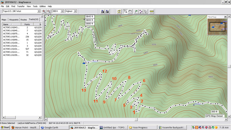
Just something to consider if you decide to do further exploration: the overlay's version of the Four Mile Trail comes very close to Turn #6 of the first set of switchbacks (past the transverse). In past hikes on the Four Mile Trail, I've noticed the start of what looks like a use trail at Turn #6 that heads NE around some of the boulders (IIRC). I'm starting to wonder if this use trail might connect to that possible old alignment of the Four Mile Trail. It's something I've been thinking of exploring further the next time I'm in Yosemite.


Re: Agassiz Column, Moran Pt. and Old 4 Mile Trail
October 11, 2011 09:19PM
I think I know the section of trail (near #6) that you are referring to; I assumed it was part of the older, steeper trail that crosses the current trail a few times above Union Point. I'm a bit skeptical of the alignment in the overlay above--the current alignment up the open slope above Union Point follows a generally good route that is sunny, not steep, and is generally free of big rocks, and the trail's builder John Conway was a good trail engineer (he also did the Yosemite Falls trail, the Nevada Mist trail, and the Chilnualna Falls trail). The slope above Moran Point didn't seem to me as good a place for a trail--steep, rocky, unstable, and more likely to hold snow and ice--unless views were a priority. Conway died before the segment above Union Point wa completed, but the surveying had been completed.

The Linda Greene Historic Resource Study book (p. 102) claims that the trail was "slightly" rerouted in 1923 and I could find no mention of further rerouting, although based on the maps above there were at least two later changes, both on the USGS maps until recently: just below Union Point and the long traverse west of Glacier Point. (Greene also quotes Helen Hunt Jackson as believing that the trail's original owner James McCauley was living at Union Point, although Greene believes she had seen just an equipment shed.)

FWIW, I have read elsewhere that the trail was opened as a toll trail before the segment above Union Point was complete, although it seems it was finished within a few years of reaching Union Point.
avatar Re: Agassiz Column, Moran Pt. and Old 4 Mile Trail
October 17, 2011 07:20AM
Good info. The old trail section you speak of is easily found and followed...
at least the portion that connects between 6/7 and 10 on map above.
Other than that I wasn't able to really find anything else that was recognizable
to me other than a few steps right at Moran Pt. area (which is expected).
Above Moran there are 2 additional pts. and an incredible column.
All are worth exploring. As for a trail heading up from Moran... I just don't see it.


Chick-on is looking at you!


Edited 1 time(s). Last edit at 10/17/2011 08:17AM by chick-on.
Re: Agassiz Column, Moran Pt. and Old 4 Mile Trail
October 17, 2011 09:21AM
Did you try to follow the old 4MT up from point 6? I'd expect that this becomes the old section of trail that undulates around various rocks and gullies below the current blasted-out traverse section before re-joining the modern alignment at an obvious junction when it re-enters the trees. That portion of trail seems to be mostly intact (at least from the safety of the modern trail), although the sections where it crosses a few gullies looked sketchy...
avatar Re: Agassiz Column, Moran Pt. and Old 4 Mile Trail
October 17, 2011 08:51PM
Nope. Only did the section from 6/7 to 10. I have tracks of that.
Also went to all three of the "points" near Moran (including Moran).

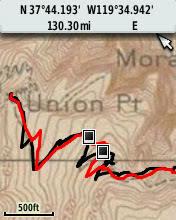
If you overlay the tracks above and map above you get exactly what I saw:

or to make it perhaps clearer:


And a portion of that old trail:


Pretty much did this:
blue is old trail
pink is other excursions on this trip looking for other portions
just east of GP WW trail from 4 mile ... that old section is there at the start... but overgrown (only followed it for about 10 ft)


Guess need to go back again and follow Old 4 Mile trail entirely...


Chick-on is looking at you!
avatar Re: Agassiz Column, Moran Pt. and Old 4 Mile Trail
October 17, 2011 08:56PM
Ok, you put up with that...

Here's another shot of Agassiz (be VERY careful not to kick rocks below if you go off off-trail):
I really like this one b/c it kinds looks Easter Island statuesque:


Crappy lighting... but this is WAY bigger than Agassiz:


And, here's looking down on Moran (from just south):


There was nothing that looked like trail west of Union. (you should go there and spy Agassiz though)


Chick-on is looking at you!
Re: Agassiz Column, Moran Pt. and Old 4 Mile Trail
October 17, 2011 10:36PM
Quote
chick-on
There was nothing that looked like trail west of Union. (you should go there and spy Agassiz though)

I took a quick peek here--lots of shrubbery (ick) and it seems that the trail would have gone past where the microwave reflector thingie is, and they chopped down a lot of trees in this area (for the reflector?), so there's probably not much left here...

The last seven or so photos here are portions of the old trail below the current traverse.

I'll definitely be back--if only to check out Agassiz!
avatar Re: Agassiz Column, Moran Pt. and Old 4 Mile Trail
October 18, 2011 07:17AM
Whoa! Cool. Thanks for those. Def. got to go see those.
(I take it that is the section just above switcher 5/6)
Nice photos of the sections below Union too. In that realm... here is the trail spied from
the rock JUST east of the railing:

The arrows point to "obvious" trail... har har.. the dotted line is the way down from Union Pt. comfort station area.

And here is the bit of also "obvious" rock work out on Moran Pt.:


Also in the same realm... wondering if anyone has taken the old railbed ALL the way from Henness Ridge to Alder Creek Falls and beyond.
(that's actually where I spent the night... and then trekked to my favorite Apsen Grove... but it needs another week or so) (it was still nice though) smiling smiley


Chick-on is looking at you!
avatar Re: Agassiz Column, Moran Pt. and Old 4 Mile Trail
October 18, 2011 11:09AM
Quote
chick-on

In that realm... here is the trail spied from the rock JUST east of the railing:


The arrows point to "obvious" trail... har har.. the dotted line is the way down from Union Pt. comfort station area.


Thank you for this photo! It puts into perspective what I need to do to reach the old trail.

The green dots that I added to the photo is the path I took from the old comfort station location. As you can tell, I went just a tad too south from the path you took, though it seems, based on one of your solid red lines, that I walked right past where the old trail intersects the path I took.


Re: Agassiz Column, Moran Pt. and Old 4 Mile Trail
October 18, 2011 03:41PM
Quote
chick-on
Whoa! Cool. Thanks for those. Def. got to go see those.
(I take it that is the section just above switcher 5/6)
Nice photos of the sections below Union too. In that realm... here is the trail spied from
the rock JUST east of the railing:

The arrows point to "obvious" trail... har har.. the dotted line is the way down from Union Pt. comfort station area.

And here is the bit of also "obvious" rock work out on Moran Pt.:


The pictures I posted were from the traverse section that's east of the uppermost switchback (2); the old trail is maybe 50' below (north of) the current one. I believe the last place to pick this segment up from the current trail heading up is near 6.

Thanks for the picture of the route near Union Point. I was looking too far to the west :-( I'll also have to check out those steps near Moran Point... they remind me a bit of some of the old steps along the Sierra Point trail.
avatar Re: Agassiz Column, Moran Pt. and Old 4 Mile Trail
October 31, 2011 07:07PM
Quote
chick-on

In that realm... here is the trail spied from the rock JUST east of the railing:


The arrows point to "obvious" trail... har har.. the dotted line is the way down from Union Pt. comfort station area.


And from another thread:
Quote
chick-on

Again, it was a quick zig from comfort station heading almost due east.
From there trail heads due north toward Agassiz. Looking at the
photo of the railing and where Agassiz is.. it is darn close.. and I maybe
touched 1 Manz shrub on the way to it... the other shrub just says hello...
it doesn't try kicking you in the groin as you go by like Manz does.
Sorry I didn't take a photo from the rock to the east of the railing.
I will next time. Good luck


First, many thanks for all the information you have provided about reaching Agassiz Column on this and other threads. Last Tuesday, during late afternoon I was back at Union Point. Unfortunately, I didn't see how anyone could do a "quick zig" from the former comfort station location due east without engaging in major bushwhacking though the thick and dense shrubs east of the comfort station location. So my question is how much bushwhacking (in feet or yards) did you have to engage in before you got into some sort of clearing?

Generally speaking, I prefer not to step on roots or live branches of shrubs or trees while exploring inside National Parks since I think it could cause damage to living plants which I always try to avoid. If I can tread on dirt or rock while pushing back branches and leaves, I'm fine with that sort of bushwhacking.

So was there a route through the thick shrubs from the comfort station area that one could weave through the bushes without stepping on too many exposed roots or branches that I missed spotting?

Also in regards to the photo above, I think I spotted where the "obvious" trail (that you pointed out with arrows) comes up to the level ground east of the comfort station. It's right next to an small shruby oak tree where a small somewhat thick low lying branch of the oak tree partial obstructs the "trail". I doubt this was an official part of the old Four Mile Trail, since I think it's too steep and narrow for any stock animal to safely traverse. But it sure looks like a usable foot trail that had been recently used. (There was an empty candy bar wrapper near the oak tree, plus some other foot prints leading toward the gap.) If it wasn't so late in the day, I would have explored further this possible trail down to the Four Mile Trail and Agassiz Column. Something I'll try to check out further during my next visit to the area.


avatar Re: Agassiz Column, Moran Pt. and Old 4 Mile Trail
October 31, 2011 09:57PM
Honestly it's probably less than 50 ft. Brush is very resilient. I wouldn't worry too much about
stepping on it. Just bust through it avoiding the Manzanita. I said due east... but it's probably
more northeast. Manz. and Mtn. Sagebrush is incredibly resilient. If you are worried about
causing any damage (very doubtful)... then you should probably just stay on the trail.
The busting through shrub further below... is much more severe.
I'm somewhat amused in that you don't want to brush aside brush... but you want to cut down
trees on Old Tioga. But seriously... unless you weigh a zillion pounds... and you jump up
and down on the shrub... it's doubtful you'll do any damage.
As for the trail east of comfort... (south of where I drew)... last time I went up that way a bit..
but to continue all the way to new 4 mile... would require crawling on hands and knees...
since it was overgrown with manz. Manz just doesn't give... and likes to grab you.
Anyway, just go for it man. You can thank me later.

I'm beating a dead chick-on to death... but here you go:


and I'm a standing on the old trail in this one:


All that being said... and what I said... I have a high tolerance for shrubbery.
YMMV

Good luck


Chick-on is looking at you!
avatar Re: Agassiz Column, Moran Pt. and Old 4 Mile Trail
October 31, 2011 10:32PM
Quote
chick-on
Honestly it's probably less than 50 ft. Brush is very resilient. I wouldn't worry too much about
stepping on it. Just bust through it avoiding the Manzanita. I said due east... but it's probably
more northeast. Manz. and Mtn. Sagebrush is incredibly resilient. If you are worried about
causing any damage (very doubtful)... then you should probably just stay on the trail.
The busting through shrub further below... is much more severe.
I'm somewhat amused in that you don't want to brush aside brush... but you want to cut down
trees on Old Tioga. But seriously... unless you weigh a zillion pounds... and you jump up
and down on the shrub... it's doubtful you'll do any damage.
As for the trail east of comfort... (south of where I drew)... last time I went up that way a bit..
but to continue all the way to new 4 mile... would require crawling on hands and knees...
since it was overgrown with manz. Manz just doesn't give... and likes to grab you.
Anyway, just go for it man. You can thank me later.

I'm beating a dead chick-on to death... but here you go:


Thanks for all the information and the photos. Where you drew the arrow in the above photo is where I guessed you might have started your bushwhacking down the slope. But I'm glad that your confirmed it with your photo. Again, thanks for all this information. It's been very helpful.


Re: Agassiz Column, Moran Pt. and Old 4 Mile Trail
November 20, 2011 10:30AM
Quote
chick-on

I'm beating a dead chick-on to death... but here you go:

For those using this picture as a guide, respect the slight turn in the chicken's arrow towards the right (in other words, don't get impatient and head to the left too soon), otherwise you'll end up well above the old trail and have to thrash down to it.
avatar Re: Agassiz Column, Moran Pt. and Old 4 Mile Trail
November 20, 2011 06:57PM
Thanks for the tip!
Re: Agassiz Column, Moran Pt. and Old 4 Mile Trail
October 17, 2011 09:17PM
Quote
chick-on
just east of GP WW trail from 4 mile ... that old section is there at the start... but overgrown (only followed it for about 10 ft)

So the trail that is just past the GP WW maintenance trail (which I think was also mentioned in wherever's post last year) is the old 4 MT? Looking at the overlaid maps that makes sense... I think I gave that trail about 10 feet as well--after the manzanita thrash below Union Point I was in no bushwhacking mood...
avatar Re: Agassiz Column, Moran Pt. and Old 4 Mile Trail
October 17, 2011 09:43PM
That was my conclusion after putting what whatever said above and the overlaid map
into my computing device in the correct orientation (nort up).


Chick-on is looking at you!
Re: Agassiz Column, Moran Pt. and Old 4 Mile Trail
October 18, 2011 06:55AM
Quote
basilbop
Quote
chick-on
just east of GP WW trail from 4 mile ... that old section is there at the start... but overgrown (only followed it for about 10 ft)

So the trail that is just past the GP WW maintenance trail (which I think was also mentioned in wherever's post last year) is the old 4 MT? Looking at the overlaid maps that makes sense... I think I gave that trail about 10 feet as well--after the manzanita thrash below Union Point I was in no bushwhacking mood...

Ha. I have followed that thing all the way back up to the current trail. I thought that it was a decoy, to sucker people who wanted to find the waterworks trail. It is a nasty bushwhack. But in retrospect, it seems to be too well built at the ankle level to be just a decoy.
avatar Re: Agassiz Column, Moran Pt. and Old 4 Mile Trail
October 11, 2011 07:26PM
Just to keep things in perspective of the old maps you posted above. The oldest one is dated 1918. The original Four Mile Trail was constructed in 1872, 46 years BEFORE 1918. I've also read that the first rerouting of the Four Mile Trail took place in the early 1900's (I'm trying to find the exact year) so even the 1918 map could very well be showing a newer alignment of the Four Mile Trail than the one originally constructed in 1872. Just one more thing to think about.

(Also that western alignment of the Four Mile Trail past Union Point shown on the overlay looks like it could very well be a doable route and possibly part of the original trail.)


Re: Agassiz Column, Moran Pt. and Old 4 Mile Trail
October 11, 2011 09:53PM
avatar Re: Agassiz Column, Moran Pt. and Old 4 Mile Trail
October 12, 2011 06:49AM
avatar Re: Agassiz Column, Moran Pt. and Old 4 Mile Trail
October 12, 2011 06:50AM
Re: Agassiz Column, Moran Pt. and Old 4 Mile Trail
October 12, 2011 04:13PM
Quote
chick-on
Deja Vu all over again wink

http://yosemitenews.info/forum/read.php?3,46585,47184#msg-47184

If the top were slightly rounder, I suppose it could be "Andrez Agassiz?"Head roll


Edited 1 time(s). Last edit at 10/12/2011 04:14PM by Ohnivy-Drak.
avatar Re: Agassiz Column, Moran Pt. and Old 4 Mile Trail
October 18, 2011 06:01PM
One last overlay map ... 1934 vs. "current" USGS for the 3 people who care:


Ah what the heck... the wifey really liked this one... so here it is:


Chick-on is looking at you!
avatar Re: Agassiz Column, Moran Pt. and Old 4 Mile Trail
October 18, 2011 06:19PM
Quote
chick-on
One last overlay map ... 1934 vs. "current" USGS for the 3 people who care:
Thanks!

As for 'who care'...there's so much to do that I can't honestly say I'll explore in this area, but I am making a mental note of these discussions in case it bubbles up on the to-do list.
avatar Re: Agassiz Column, Moran Pt. and Old 4 Mile Trail
October 18, 2011 06:30PM
Quote
chick-on
One last overlay map ... 1934 vs. "current" USGS for the 3 people who care:


Hmm... I think I might have been on the very beginning of that old trail from Union Point to Moran Point as it heads east and crosses the current Four Mile Trail. But shortly after it crosses the current Four Mile Trail low lying tree limbs help block the path as it gains elevation as it approaches the small rock wall near that large microwave reflector. It wouldn't surprise me if that microwave reflector was built on or near the old Moran Point trail.


Quote
chick-on
Ah what the heck... the wifey really liked this one... so here it is:


Very nice photo, indeed. I read elsewhere that "The Mitten" is located off the Waterworks trail. Is that true? Or is it closer to Union Point, Agassiz Column and the other columns in the general vicinity of Agassiz Column and Union Point?


avatar Re: Agassiz Column, Moran Pt. and Old 4 Mile Trail
October 18, 2011 09:15PM
Are you sure you didn't read it from the clown over here ?


Chick-on is looking at you!
avatar Re: Agassiz Column, Moran Pt. and Old 4 Mile Trail
October 18, 2011 09:35PM
Yes, that's the clown (your words, not mine). He is rarely heard from on this board anymore. wink

(BTW, I asked the question because you posted that nice photo on this thread about Agassiz Column and Moran Point, instead of the GP Waterworks thread that you posted to yesterday. So I thought "The Mitten" might be closer to Agassiz Column than the GP Waterworks.)

So anyway, how far up the waterworks trail is that column?


Edited 1 time(s). Last edit at 10/18/2011 10:08PM by plawrence.
avatar Re: Agassiz Column, Moran Pt. and Old 4 Mile Trail
October 19, 2011 02:10PM
It's on the works above Glacier Pt. Not the trail below.

Again, the most impressive column is actually in the 2nd photo:
http://yosemitenews.info/forum/read.php?3,47695,47882#msg-47882

Approx. elevation of the 3 columns: 7250, 6600, 6300


Chick-on is looking at you!
avatar Re: Agassiz Column, Moran Pt. and Old 4 Mile Trail
October 19, 2011 06:39PM
Quote
chick-on

It's on the works above Glacier Pt. Not the trail below.

Again, the most impressive column is actually in the 2nd photo:
http://yosemitenews.info/forum/read.php?3,47695,47882#msg-47882

Approx. elevation of the 3 columns: 7250, 6600, 6300


Thanks for the info. Much appreciated!


Edited 1 time(s). Last edit at 05/29/2014 04:57PM by plawrence.
Re: Agassiz Column, Moran Pt. and Old 4 Mile Trail
October 18, 2011 06:58PM
Okay that is a really cool picture.
Re: Agassiz Column, Moran Pt. and Old 4 Mile Trail
October 18, 2011 09:53PM
Great map! Thanks. It also has the best map of the Ledges Trail that I have ever seen.
avatar Re: Agassiz Column, Moran Pt. and Old 4 Mile Trail
November 02, 2011 03:18AM
Something I just noticed tonight (don't know if it's been discussed before), but as recently as the 1970 USGS Topo Map of Yosemite Valley (that's also listed in the links at the bottom of this page), the Four Mile Trail's traverse between Glacier Point and the first set of switchbacks still used the western portion 1934 alignment as shown on your overlay.


Below is a cropped portion of that 1970 USGS topo map. The dashed black line shows the 1970 alignment of the Four Mile Trail while I added the BLUE DOTS to show approximately where the current alignment of the traverse is:


Note that from the switchbacks, the modern alignment of the traverse goes up what was once the first portion of the trail that heads up to Sentinel Dome, but then continues east towards Glacier Point (as the old trail to Sentinel Dome turns the corner and heads west up the slope continuing on towards the Pohono Trail and Sentinel Dome).


Edited 1 time(s). Last edit at 11/02/2011 09:40AM by plawrence.
Re: Agassiz Column, Moran Pt. and Old 4 Mile Trail
November 02, 2011 09:56AM
Quote
plawrence
Below is a cropped portion of that 1970 USGS topo map. The dashed black line shows the 1970 alignment of the Four Mile Trail while I added the BLUE DOTS to show approximately where the current alignment of the traverse is:


Note that from the switchbacks, the modern alignment of the traverse goes up what was once the first portion of the trail that heads up to Sentinel Dome, but then continues east towards Glacier Point (as the old trail to Sentinel Dome turns the corner and heads west up the slope continuing on towards the Pohono Trail and Sentinel Dome).


What a great bit of map! I once spent some time hiking with a map that showed the link between the Four Mile Trail and and the Sentinel Dome Trail as a couple of dashes right down the ridge, and a little bit to the east. Needless to say, there is nothing going right down the ridge, and I failed to find it. Now I see that the old trail link went down in switchbacks a bit west of the ridge. You can be sure that I'll look there again.

Actually, I don't that was a shortcut. I think that was the actual Four Mile Trail before they blasted the balcony on the current trail. That would also explain why the Sentinel Dome Trail goes level and way off to the west before heading up the hill....it was part of the Four Mile Trail before they built the new lower route.

Four those of you who are abandoned trail fans, here are a couple of comments about this map fragment. The lines with long dashes and small dots is an imaginary boundary of the wilderness area. It jogs off the map just above "BDY" because that is where the power line and pipe to the old waterworks go. The solid dots on the Sentinel Dome / Pohono Trail signify that the water pipe and buried power line run under that bit of trail. You can see the Glacier Point parking lot in the lower right corner. The current Four Mile Trail leaves just north of the parking lot, but if I am right, then it used to come in with the Sentinel Dome trail just above the parking lot, heading for the old hotel. The unnecessary bend in the current Four Mile Trail just below "7214" is because that was originally the start of the Ledge Trail (see other maps above), and when they re-routed the Four Mile Trail, they made a junction with it.

Of course, nobody but a bushwhacking historian would care about these details....
avatar Re: Agassiz Column, Moran Pt. and Old 4 Mile Trail
November 02, 2011 11:01AM
Quote
wherever

I think that was the actual Four Mile Trail before they blasted the balcony on the current trail. That would also explain why the Sentinel Dome Trail goes level and way off to the west before heading up the hill....

Do you remember what year the Park Service blasted the balcony of the current Four Mile Trail?


Re: Agassiz Column, Moran Pt. and Old 4 Mile Trail
November 02, 2011 11:28AM
Quote
plawrence
Quote
wherever

I think that was the actual Four Mile Trail before they blasted the balcony on the current trail. That would also explain why the Sentinel Dome Trail goes level and way off to the west before heading up the hill....

Do you remember what year the Park Service blasted the balcony of the current Four Mile Trail?


Dunno. The trail was built in 1872. The first big rebuilding of the trail was in 1901, when it went to 4.8 miles. There was another revision in 1923. Some of the balcony stonework looks a lot newer than that. Here is what the park history says: (link)

In the 1920s the Park Service slightly rerouted the trail and changed its grades until it is now nearer five miles long; it still, however, retains the historic name. ....

....The old abandoned trail parallels the present one up the talus slope below Sentinel Rock. It begins on the valley floor about fifty yards east of the present trail and proceeds via five switchbacks to the base of Sentinel Rock, which it avoids by swinging 1,300 yards to the east. After another 200-yard swing to the west, the old trail enters another series of switchbacks to avoid a short rock-filled chimney at an elevation of 1,200 feet above the floor. From there to Union Point is another irregular series of zigzags, turning to the east and southwest, a prime example of Conway’s engineering competence. Union Point is 2,314 feet above the valley floor, and from there one can see Yosemite Fall, Half Dome, North Dome, El Capitan, Cathedral Rock and Spires, and the Big Oak Flat and Wawona roads.

The trail continues in several long, gentle switchbacks to an elevation of 7,000 feet. There it squeezes east under and over precipitous granite cliffs, emerging within sight of Glacier Point’s overhanging rock. Then the early-day hiker followed a level stretch of trail and made the last climb of a 100-yard rise to Glacier Point.

The impressive engineering and construction skills of the builder are apparent everywhere. Abandonment of the trail and construction of the present one in 1923 have hastened obliteration of the old trail, but only in the narrow, rock-filled chimney below Union Point is one unable to follow its course. The modern trail, paralleling the old, traverses an additional 0.6 mile to eliminate a one-step grade. The present Four-Mile Trail, therefore, is actually 4.6 miles long.


I haven't seen any record of actual details of the construction.
avatar Re: Agassiz Column, Moran Pt. and Old 4 Mile Trail
November 02, 2011 12:31PM
Quote
wherever

I haven't seen any record of actual details of the construction.

Thanks for the detail history of the old trail.

The reason I asked was I was a bit surprised that according to the 1970 USGS topo map that the trail as late as the 1960's was aligned along the old lower traverse towards Glacier Point. So sometime between the creation of the 1970 USGS topo map and the present day, it appears that a new higher traverse was constructed connecting the first set of switchbacks with Glacier Point. I had thought that the present travserve that is being used was constructed a lot earlier.
Re: Agassiz Column, Moran Pt. and Old 4 Mile Trail
November 02, 2011 12:52PM
Quote
plawrence
The reason I asked was I was a bit surprised that according to the 1970 USGS topo map that the trail as late as the 1960's was aligned along the old lower traverse towards Glacier Point. So sometime between the creation of the 1970 USGS topo map and the present day, it appears that a new higher traverse was constructed connecting the first set of switchbacks with Glacier Point. I had thought that the present travserve that is being used was constructed a lot earlier.

Well, your blue dots contour pretty well, but the dashed line just below (north) of them look like they were inked in very approximately. It may just be that this portion of the trail wasn't viewable in the stereo photos that they used to trace the trail onto the map...
Re: Agassiz Column, Moran Pt. and Old 4 Mile Trail
November 02, 2011 01:32PM
Quote
wherever
... the dashed line just below (north) of them look like they were inked in very approximately. It may just be that this portion of the trail wasn't viewable in the stereo photos that they used to trace the trail onto the map...

The "lower" traverse section of the Four Mile Trail can be seen easily from the current blasted-out section, and the USGS route looks about right. The main issues with the old alignment seemd to be that that the trail had to drop a bit to avoid the cliffs that were later blasted through and it had to undulate a bit around some rocky sections. It also crossed a few active gullies that probably required frequent maintenance--the trail has all but been obliterated where it crosses these.

As posted above, the last several pictures here are of sections of this old alignment. (The earlier pix in this series are abandoned sections of the trail further down, including the impressive switchbacks below Union Point...)

Heading down/west, this is where the old alignment branches off (to the right) from the modern trail:


Other than the "one slip and you're dead" gullies and the fact that you're below a normally busy trail where inexperienced hikers could accidentally kick rocks onto you, the old trail looks passable.
avatar Re: Agassiz Column, Moran Pt. and Old 4 Mile Trail
November 10, 2011 01:14PM
Here are a couple of short videos that show where this old alignment of the trail diverges from the present trail and where it runs roughly parallel just below the present trail:


avatar Re: Agassiz Column, Moran Pt. and Old 4 Mile Trail
January 17, 2012 07:32AM
Hiked the entire old trail from Union Pt. to where the trail reconnects just
east of the traverse along the cliff face heading to/fro Glacier Pt. last Saturday. (Jan 14th!)
Some portions did on way down... some on way up... some ridiculously overgrown...
but the traverse and a couple of switchbacks are still in fabulous shape.
From GPS:


and merging the two into a current map:


Two of the old trail traverse:


I'll upload a set later


Chick-on is looking at you!
Re: Agassiz Column, Moran Pt. and Old 4 Mile Trail
January 17, 2012 07:34AM
Fabulous! Thanks.
avatar Re: Agassiz Column, Moran Pt. and Old 4 Mile Trail
January 17, 2012 10:18AM
Here's the set... they are geo-tagged... best to view in Google Earth...
if there's a photo and it sorta looks like a trail or it just looks like shrubbery...
then it's probably the trail..
Enjoy

Set O Old 4 Mile Trail Faux Toes Above Union

I can draw the trail in in any photos if something doesn't make sense and someone wants some sense.
If someone wants to send me some sense... I'll take dollars.

Enjoy


Chick-on is looking at you!


Edited 1 time(s). Last edit at 01/17/2012 10:19AM by chick-on.
avatar Re: Agassiz Column, Moran Pt. and Old 4 Mile Trail
January 17, 2012 04:38PM
Thanks for the post! We were planning to head up that route as well on Saturday for a couple of nights out, but the Wilderness office told me that it was "summer rules" as far as camping out (i.e. no camping at Glacier Point and I didn't feel like stealth camping), so we went to the north rim for a couple of nights. Gonna plan on following in your footsteps up this route sometime this summer.
avatar Re: Agassiz Column, Moran Pt. and Old 4 Mile Trail
January 18, 2012 01:32AM
Thanks for posting all those photos.

How hard did you find hiking the Old Four Mile Trail that runs below the traverse portion of the current trail? How was the exposure on that portion of the old trail?

I also admire you bushwhacking skills. That portion closest to Union Point appeared to be seriously overgrown with manzanita and other shrubs.
avatar Re: Agassiz Column, Moran Pt. and Old 4 Mile Trail
January 18, 2012 07:02AM
Quote
plawrence
Thanks for posting all those photos.

How hard did you find hiking the Old Four Mile Trail that runs below the traverse portion of the current trail? How was the exposure on that portion of the old trail?

I also admire you bushwhacking skills. That portion closest to Union Point appeared to be seriously overgrown with manzanita and other shrubs.
You are welcome

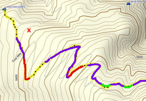
Here's the map above marked up a bit:
Red = Seriously Overgrown - good luck - be happy it's not ALL Manzanita (sections I would only do maybe once again)
Purple = Not bad at all or nothing really serious IMO (definitely sections I would do again without hesitation)
Green = Avalanche traverse (1st one closest to GP) and Super Steep dirt slope (2nd one - closer to Union)


The traverse section was a cakewalk in my book. So much so I did it coming back up too. The two sections marked in the map
are the only worries. It would definitely give some people pause and you have to work around the huge down tree.
If there is snow on those slopes you better have the gear to handle it or turn around. A false step and you could definitely be
in for serious trouble. I recommend you at least have hiking sticks to cross those sections.

I have a question for you. I think I saw a relay tower in your photos at one time... near Union. I haven't a clue where the heck that is.
Is it lower than Union? Below the section from Agassiz?

Next year when the sun is furthest north... need to get back on it and take some pictures in better light... not so much of
this old trail but the great rock features. Would be fun to hike the entire old section down past Ag... then hike up the new trail.
With the Custom Maps on a Garmin GPS I should also be able to better location the old trail portions heading to Sentinel
and also the sections near the Valley.


Chick-on is looking at you!
Re: Agassiz Column, Moran Pt. and Old 4 Mile Trail
January 18, 2012 08:02AM
Quote
chick-on
I have a question for you. I think I saw a relay tower in your photos at one time... near Union. I haven't a clue where the heck that is.
Is it lower than Union? Below the section from Agassiz?

Are you talking about this thing?
http://yosemitenews.info/forum/read.php?3,46585,47192#msg-47192

I don't remember exactly where I saw it recently, but I think it was above the walk over to Moran Point.
Re: Agassiz Column, Moran Pt. and Old 4 Mile Trail
January 18, 2012 09:34AM
Quote
wherever
Quote
chick-on
I have a question for you. I think I saw a relay tower in your photos at one time... near Union. I haven't a clue where the heck that is.
Is it lower than Union? Below the section from Agassiz?

Are you talking about this thing?
http://yosemitenews.info/forum/read.php?3,46585,47192#msg-47192

I don't remember exactly where I saw it recently, but I think it was above the walk over to Moran Point.

This thing?


Apparently it's a microwave reflector. The microwave receiver on the valley end seems to be near the cemetery; I assume the other side is on Turtleback Dome. The reflector is just above Union Point--you can see it from the trail maybe 50 paces past the Union Point junction on your left (going up), but you need to be able to peek over the bushes to see it. I would have guessed that the lowest segment of the old trail (this is it from the "top", near where the waterworks trail starts) passes near it...

avatar Re: Agassiz Column, Moran Pt. and Old 4 Mile Trail
January 18, 2012 10:05AM
Ok, thanks. I dunno. I didn't run smack dab into it and I didn't see it. I was thinking about it.
Looking around... but sometimes you miss stuff right in front of you. Perhaps I was more
in tune with following the trail.

Take a look at #45 on ... it's the lower section ... (45 is just a bit below where your photo was taken)

Set O Old 4 Mile Trail Faux Toes Above Union

I'll find it next time. Thanks


Chick-on is looking at you!
avatar Re: Agassiz Column, Moran Pt. and Old 4 Mile Trail
January 18, 2012 10:22AM
(My guess is that the old trail to Moran Point passes near it. wink )

Here is its approximate location (marked with a red X) about 50 feet above the current Four Mile Trail on your GPS track map:


Edited 1 time(s). Last edit at 01/18/2012 10:23AM by plawrence.
avatar Re: Agassiz Column, Moran Pt. and Old 4 Mile Trail
January 30, 2012 06:07PM
Had some time Sunday so I checked out the lowest portion of the 4 Mile trail ...
the section from the Trailhead on Southside Drive to Sentinel Creek crossing
below Sentinel Rock.
For those that love this stuff... the lower portion can be hiked almost in entirety.
Takes a bit of looking.. but amazingly it is still there.

Using an old map loaded into my Garmin eTrex 30 was able to hike this:


Almost gave up when spied an obvious turn in the old trail. After that it was
fairly easy to follow... YMMV! smiling smiley

Set of photos here

Enjoy (or just Have a Nice Day)
tongue sticking out smiley


Chick-on is looking at you!
avatar Re: Agassiz Column, Moran Pt. and Old 4 Mile Trail
January 30, 2012 10:28PM
Thanks for taking and sharing all those photos. I never would have thought that so much of the old trail would appear to be in fairly good and passible condition after all these years of non-use. Fascinating.


Re: Agassiz Column, Moran Pt. and Old 4 Mile Trail
January 31, 2012 09:18AM
Quote
chick-on

For those that love this stuff... the lower portion can be hiked almost in entirety.
Takes a bit of looking.. but amazingly it is still there.

Thanks again for sharing! I like that old switchback in #35... I think there's one more segment of old trail to be re-discovered: the pre-'34 trail left the new one somewhere along the long, lower traverse that crosses the creek and climbed several switchbacks before rejoining the new trail below Union Point...
avatar Re: Agassiz Column, Moran Pt. and Old 4 Mile Trail
January 31, 2012 11:34AM
Quote
basilbop
Quote
chick-on

For those that love this stuff... the lower portion can be hiked almost in entirety.
Takes a bit of looking.. but amazingly it is still there.

Thanks again for sharing! I like that old switchback in #35... I think there's one more segment of old trail to be re-discovered: the pre-'34 trail left the new one somewhere along the long, lower traverse that crosses the creek and climbed several switchbacks before rejoining the new trail below Union Point...

Back at you. My pleasure.

#6 is the same as #35... this where found the trail and then the hunt was really on for the entire thing.
Yes, next up is the section between Sentinel Creek and the Union Pt. wack-a-doodle past Agassiz.
I nearly started looking... but said that was enough for this time... once all sections are found...
we'll have to do the whole thing from Sentinel Dome down...
Surprisingly they haven't closed the trail for the season yet....


Chick-on is looking at you!


Edited 1 time(s). Last edit at 01/31/2012 03:00PM by chick-on.
avatar Re: Agassiz Column, Moran Pt. and Old 4 Mile Trail
January 31, 2012 11:39AM
Quote
chick-on

Surprisingly they haven't closed the trail yet this year...

I think the Park Service had, and then re-opened it. The last time I was at Glacier Point in December, the Four Mile Trail was clearly signed as closed.


avatar Re: Agassiz Column, Moran Pt. and Old 4 Mile Trail
January 31, 2012 11:55AM
Quote
plawrence
Quote
chick-on

Surprisingly they haven't closed the trail yet this year...

I think the Park Service had, and then re-opened it. The last time I was at Glacier Point in December, the Four Mile Trail was clearly signed as closed.


December this year? tongue sticking out smiley (you know you'd do it to me)
smiling smiley


Chick-on is looking at you!
avatar Re: Agassiz Column, Moran Pt. and Old 4 Mile Trail
January 31, 2012 01:35PM
Did I mention a year? tongue sticking out smiley

(Yes, it was last month, December 2011).
avatar Re: Agassiz Column, Moran Pt. and Old 4 Mile Trail
January 31, 2012 12:54PM
Quote
plawrence
The last time I was at Glacier Point in December, the Four Mile Trail was clearly signed as closed.

It wasn't closed when I was there a couple of weeks ago.
avatar Re: Agassiz Column, Moran Pt. and Old 4 Mile Trail
January 31, 2012 01:38PM
December 10, 2011:


On the blue tape it states "Winter Conditions"
avatar Re: Agassiz Column, Moran Pt. and Old 4 Mile Trail
May 28, 2014 10:20PM
Quote
plawrence
Here is its approximate location ...

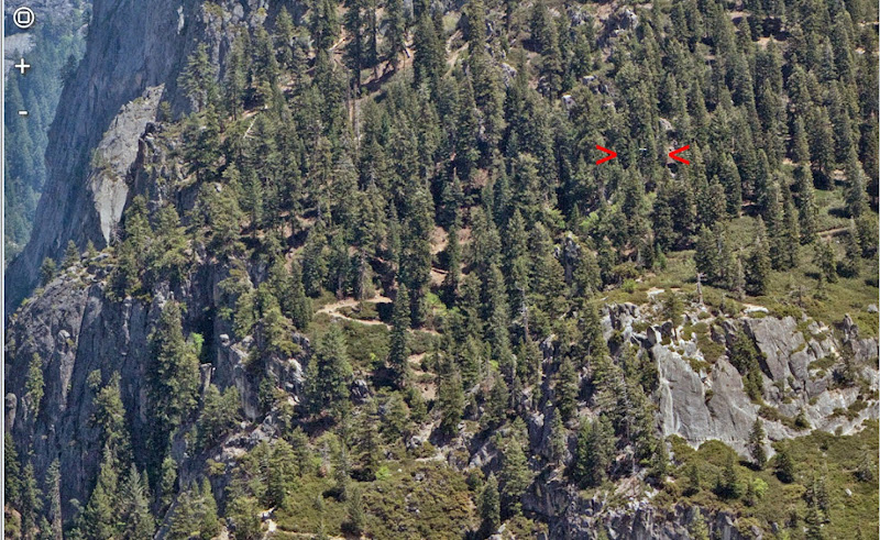
I'm pretty sure that's it between the red pointers. This was cropped from an xRez image taken from Eagle Point.


The two switchbacks visible to the left of Union Point are the ones I call "S1" and "S3". S5, the one that's closest to Moran Point, is hidden in the trees.

The little bit of trail visible at the far right is probably between the Union Point junction and the switchback I call "T1". That would put the mirror somewhere near T2.
avatar Re: Agassiz Column, Moran Pt. and Old 4 Mile Trail
June 09, 2014 11:10AM
Quote
gophersnake
The little bit of trail visible at the far right is probably between the Union Point junction and the switchback I call "T1". That would put the mirror somewhere near T2.

I was there a few days ago. I tried going straight ahead at the T2 switchback (2nd above Union Point) instead of turning, and soon found myself right above the mirror -- close, less than 50 feet. I'll post pics in a day or two.

I looked for a way down from there to the mirror itself, but kept finding the way blocked by rocks and other obstacles. By now I'm almost certain that whoever installed it, got to it from somewhere lower down.

As others have mentioned, you can get glimpses of the mirror over the manzanita from the trail both above and below the Union Point junction. If I were trying to get to it, that's where I'd start from. Since I'm not very skilled at negotiating manzanita, I'd expect to lose part of my shirt in the process.
avatar Re: Agassiz Column, Moran Pt. and Old 4 Mile Trail
June 09, 2014 12:54PM
avatar Re: Agassiz Column, Moran Pt. and Old 4 Mile Trail
November 02, 2011 02:43PM
Quote
wherever
I once spent some time hiking with a map that showed the link between the Four Mile Trail and and the Sentinel Dome Trail as a couple of dashes right down the ridge, and a little bit to the east. Needless to say, there is nothing going right down the ridge, and I failed to find it. Now I see that the old trail link went down in switchbacks a bit west of the ridge. You can be sure that I'll look there again.
Been on that section twice now very recently. When there was snow about a month ago I am certain I found a
very small portion of rock work above the pipe. Below the pipe you will be able to find the old trail (a few very large
switchbacks) which are just above the current trail and just west of the cliff traverse.
On the second trek... failed miserably trying to find anything above the pipe (between pipe and Sentinel Dome trail).
I mentioned previously also that there still exists the trail sign where the old trail met Sentinel Dome / Pohono Trail.

If weather is nice in a couple of weeks... I may well play around this area once again and follow all these
old trails. Thanks to all for the dialogue.


Chick-on is looking at you!
avatar Re: Agassiz Column, Moran Pt. and Old 4 Mile Trail
October 20, 2011 07:40AM
Found this old photo from 1919:


Chick-on is looking at you!
Re: Agassiz Column, Moran Pt. and Old 4 Mile Trail
November 14, 2011 09:01PM
Quote
chick-on
Found this old photo from 1919:


In the 1890's, long before color film was developed, a photolithographic color separation printing method was worked out, using multiple images and inks. Come to think of it, it's not that different from from what a color ink jet printer does, except that it used separate printing plates instead of separate jets. The Library of Congress has a bunch of them collected together. See link: link

Here is Agazziz Column, circa 1898.


One thing is clear: They didn't mind cutting back any brush and small trees that got in the way of a good picture.
avatar Re: Agassiz Column, Moran Pt. and Old 4 Mile Trail
November 14, 2011 10:03PM
Quote
wherever

In the 1890's, long before color film was developed, a photolithographic color separation printing method was worked out, using multiple images and inks. Come to think of it, it's not that different from from what a color ink jet printer does, except that it used separate printing plates instead of separate jets. The Library of Congress has a bunch of them collected together. See link: link

Here is Agazziz Column, circa 1898.


One thing is clear: They didn't mind cutting back any brush and small trees that got in the way of a good picture.


By the color of the sky, it looks like air pollution and smog was far worse in 1898 than it is now. wink


[just kidding, folks]


avatar Re: Agassiz Column, Moran Pt. and Old 4 Mile Trail
November 15, 2011 12:06AM
Quote
plawrence
By the color of the sky, it looks like air pollution and smog was far worse in 1898 than it is now. wink

Either that or the dyes used in film where not as good as those in Velvia.
avatar Re: Agassiz Column, Moran Pt. and Old 4 Mile Trail
November 03, 2011 12:11PM
Interesting thread. Checking out old maps and the trails as they relate to what's out there currently is very cool. There are more people who care than you may think der Baste Target.
avatar Re: Agassiz Column, Moran Pt. and Old 4 Mile Trail
November 08, 2011 07:29PM
Here's now one more data point, courtesy of the USGS historical maps that are now available for download.

The image below is from the USGS 1900 topo map of Yosemite. Note that the survey that the map is based on was conducted in 1893-94.

Here's the alignment of the Four Mile Trail shown on this map:


Note that neither Union Point nor Moran Point are marked on this early USGS topo map.

(By the way, this 1900 USGS map is one of the few maps I've seen that shows the orignal 1890 boundary of Yosemite National Park. The boundary of the park was a lot farther west than the current boundary. As example, all of Cherry Valley was inside of the original Yosemite National Park's boundaries.)


Edited 1 time(s). Last edit at 11/09/2011 12:46AM by plawrence.
avatar Re: Agassiz Column, Moran Pt. and Old 4 Mile Trail
November 13, 2011 09:36PM
You can see Agassiz Column right from the valley floor:

Taken 11/12/11:


Ok, maybe not so well with the naked eye though...
avatar Re: Agassiz Column, Moran Pt. and Old 4 Mile Trail
November 13, 2011 09:48PM
Still, it's a cool shot. Thanks for capturing it!
Sorry, only registered users may post in this forum.

Click here to login