Welcome! Log In Create A New Profile Recent Posts
Yosemite Falls

The Moon is Waxing Gibbous (58% of Full)


Advanced

Re: Chinquapin Falls bushwhack?

All posts are those of the individual authors and the owner of this site does not endorse them. Content should be considered opinion and not fact until verified independently.

Chinquapin Falls bushwhack?
November 25, 2011 08:44PM
Some daydreaming about next year's hikes.

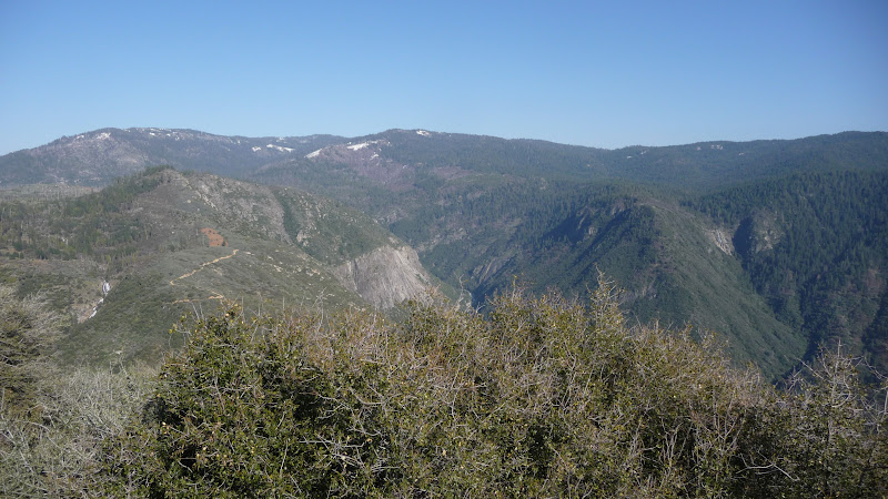
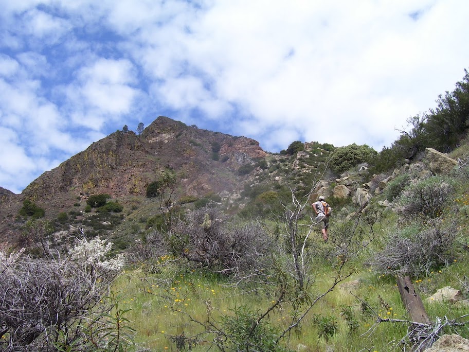
Those of you who have read my posts will recognize the theme of hiking the old abandoned roads and trails in the park. Chick-on's recent post about hiking up the old Glacier Point Road from Chinquapin towards Badge Pass reminded me that farther down the hill is an abandoned trail that used to cross Chinquapin Creek (which was re-named Indian Creek at least a hundred years ago) below Chinquapin and zigzaged down to Henness (which was the group of houses on the south side of the Merced directly opposite El Portal).

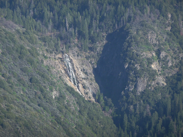
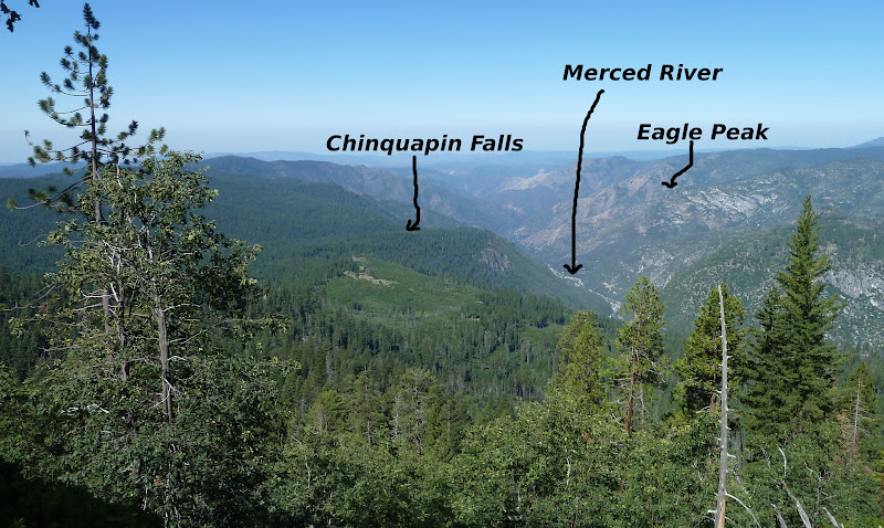
Those of you who know about the more obscure waterfalls in the park are familiar with Chinquapin Falls, which is visible during Spring runoff from the main highway in El Portal. Photos of it on the web all agree that the photo should be taken with a long lens from just east of El Portal. Here is one (link). It looks like this:


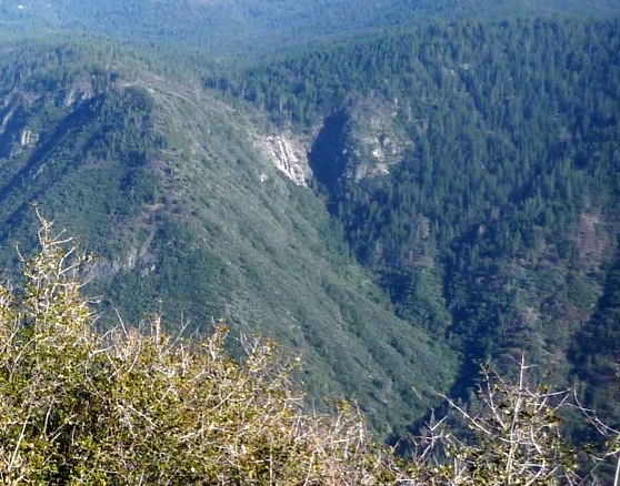
A guy on the climbers forum has posted a couple more photos of the thing. See link. Here are the thumbnails:


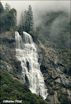
The guidebooks say that the falls is a couple of hundred feet high and you can't get closer because it's on the wrong side of the river. In 1907, the railroad's brochure described it this way:

Winding and curving, twisting and turning, ever climbing, we now reach the Hog's Back, a curve which almost completes the circle; then there is a sudden sweep to the right, and far up, 2000 feet above us on the face of the great cliff is a narrow, white band which shimmers in the light as you gaze. You are looking at the Chinquapin Falls, and the first part of your journey is over. For you have reached El Portal, the Gateway of Yosemite.

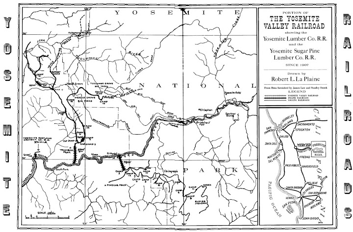
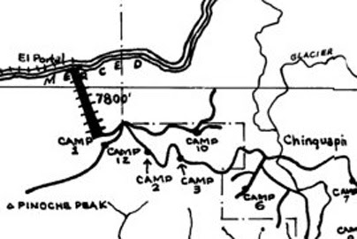
The old trail passed above the falls. Here is a bit of the 1909 USGS topo map:


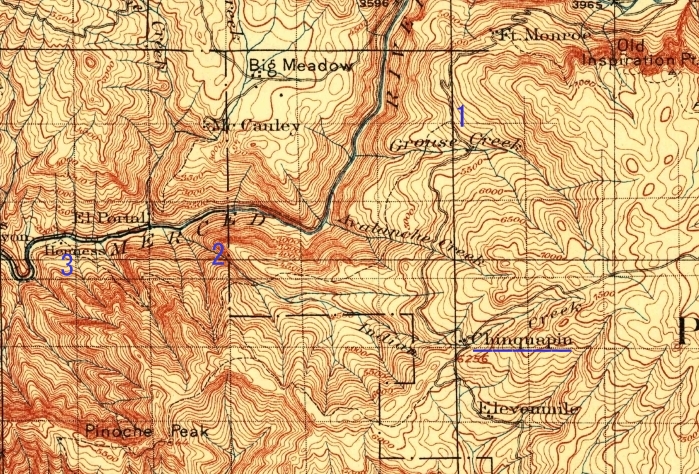
You can see that I have underlined Chinquapin, at the intersection of the old Wawona Road and the old Glacier Point Road, which had two buildings at that time. I have put a "1" where the trail to Henness left the old road near Grouse Creek, a "2" at the location of the falls, and a "3" at Henness. Although the buildings there are gone, along with whatever river crossing existed, it must be possible to still get there, because the fishing sites talk about fishing in the side creeks there. I suppose that there must be a fisherman's use trail from where highway 140 now crosses the river a bit farther west. Of course, there was no road bridge crossing the river in 1909. Highway 140 wasn't built until 1926. The dotted line trail that you see going downriver from Henness goes back up the ridge and over to Hites Cove. There was no trail or road on the south side of the river at or west of Hites Cove at that time. The north side of the river had no road, either, but it had the railroad by then.

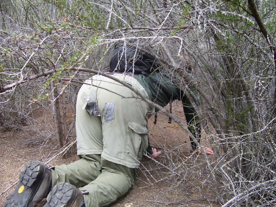
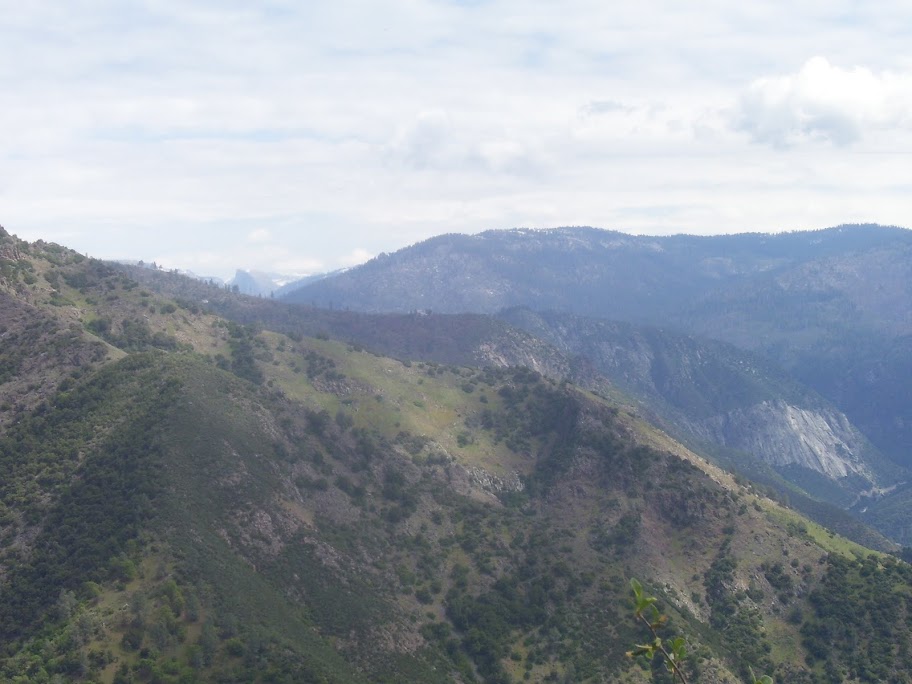
So one bushwhacking scheme would be to trace the old trail until the ridge just above and east of the falls, then follow the ridge down to where you might get a glimpse of the falls. To the west of that point, the trail gets amazingly steep, and I would be surprised if anything still exists. The biggest hiking problem is likely to be brush. The Arch Rock Fire and a few subsequent ones totally destroyed the old forest.

Questions for the forum:
1) Does anyone know anything about a fisherman's trail to Henness?

2)What is the dashed line shown on the modern map below? I have highlighted it with some red Xs. It starts at the fire road between Yosemite West to Pinoche Peak. Is it a fire break? It goes straight down the hill! You can find it here: link


If this thing were passable, it would let you contour over to the base of the falls at about the 3300 foot level....

It must be godawful steep.


Edited 1 time(s). Last edit at 01/24/2013 09:03AM by wherever.
Re: Chinquapin Falls bushwhack?
November 26, 2011 11:53PM
I was first made aware of the trail from Grouse Creek to the El Portal area by viewing an old map, perhaps the one that you showed. In 1969, an NPS colleague spoke of several elderly employees who were familiar with that trail. Two to three years ago, I posed a question of that trail to now-retired NPS employee Jim Snyder, and he said that it was obliterated in several places and hard to follow. Finally, some 4-5 years ago I found mention of a cable car that ran from El Portal to Indian homes on the west side of the Merced River at one time. Perhaps some of the old timers in the El Portal area can shed some light on that device. I'm very pleased that this type of research is being done again.
avatar Re: Chinquapin Falls bushwhack?
November 27, 2011 11:57AM
I don't know the answers to your questions.... but, of course, I've looked at this too.
Believe it or not... just this last week when looking at Old Wawona Rd. near
Fort Monroe. It's been on my noggin ever since seeing the fall from "the other" Eagle Peak:


The big picture looks like this:


I'd attack it from above rather than take that "trail" from 140. Getting a decent view of it looks like it MAY be
fairly painless since there are so many pines above it. I'd stay on the west side of the creek though.
Going to the lookout and then following Henness Ridge to 5764 and then over to 4809 looks nice...


Chick-on is looking at you!
Re: Chinquapin Falls bushwhack?
November 27, 2011 12:45PM
Thanks for the views. Yes, the east bank of the creek looks like brush hell, and the west side has trees. Mostly. But that means that there might be hope of finding the old trail and also figuring out what the dotted line on the map is.


I've been thinking some more about that dotted line. On the map it looks like a fire break, but if so, your photo shows that it hasn't been one for fifty years or more. Otherwise, it looks too steep for a trail, unless there are a lot of switchbacks not shown. More like a climbers trail. I'm guessing it's a utility put up for the three hundred or so house lots at Yosemite West. Not straight enough for power lines. Something buried, maybe, like water, gas, sewage, telephone cable....?

I will definitely have to take a look next year, if Chick-on doesn't beat me to it. Maybe even if he does.

For readers disoriented by your photo, here is some orienting info:


1 is Foresta Falls, 2 is Foresta Road, 3 is Chinquapin Falls, 4 is houses on the ridge at Foresta, and 5 is the west flank of Inspiration Ridge slanting down to the left.


Edited 2 time(s). Last edit at 11/28/2011 10:35PM by wherever.
avatar Re: Chinquapin Falls bushwhack?
November 27, 2011 02:15PM
My Garmin MapSource shows it as a trail. But I dunno. Even Coe isn't that steep!
A buddy of mine tried going to Brown / Pinoche from I believe Hite Cove trail and
he gave up on that... so I'd put the mark on the gps and hit that trail from above.
At least then you can hike on road back up to Yosemite West.
If you look at Google Earth history there used to be a firebreak on the ridge
east of Chinquapin Falls... and that sure looks like it has become overgrown.


Chick-on is looking at you!
avatar Re: Chinquapin Falls bushwhack?
November 28, 2011 09:12PM
Prob. you don't need this... but for fun...
Here's is the view from Glacier Pt. road earlier this year:


It certainly looks like an nice forested hike.

(btw... your orientation photo no longer shows correctly)

Another way would be to try to stay right on the edge of that big shrubbery area... that way you would have
nice views probably for a good distance... rather than looking at pines.

Hope this helps.


Chick-on is looking at you!
Re: Chinquapin Falls bushwhack?
November 28, 2011 10:42PM
Quote
chick-on
(btw... your orientation photo no longer shows correctly)

Well, that's revolting. But it explains one of the reasons why some of my pictures go bad on this forum. Both photos were edits of your photo, but I just uploaded the results from the Picasa editor without saving them separately. At some time since yesterday, Picasa found that they had the same apparent source ID. Even though the pixels were different, it deleted the first one and substituted a pointer to the second. Somebody's bit-saving routine for eliminating duplicates in storage, I suppose....

It should be fixed this time. See above.


Edited 1 time(s). Last edit at 01/09/2012 05:25PM by wherever.
avatar Re: Chinquapin Falls bushwhack?
November 29, 2011 07:15AM
Just a bit of clarification... the ridge in the upper left.... that is Inspiration Ridge.
Remember if you zip down the far side of it you get right to Pohono Trail and Old Inspiration
and a grand view of the valley. Obviously if you did that on #5 you wouldn't get that..
What you would run into is Grouse Creek.

I looked at the old map again... and noticed an interesting tidbit....
If you recall I said I'd go to lookout and then along Henness... it appears that
the current "trail" (still on the park map today) used to go along Henness...
although currently there appears to be two buildings at the terminus of
that "trail" today.

Also interesting... there is a large asphalt pad with a triangle and H
on it next to the lookout tower... I presume this is both a helicopter
landing pad... and also a indicator (H=Henness) ?
Doesn't look like any toper has landed there in ages though.

Anyway, I need to go back into that area and knock off that bit of trail
and also check out Elevenmile Meadow...
I'll take a look next time I'm on 140 for the trail down below.


Chick-on is looking at you!
Re: Chinquapin Falls bushwhack?
November 29, 2011 08:33AM
Quote
chick-on
Just a bit of clarification... the ridge in the upper left.... that is Inspiration Ridge.
Remember if you zip down the far side of it you get right to Pohono Trail and Old Inspiration
and a grand view of the valley. Obviously if you did that on #5 you wouldn't get that..
What you would run into is Grouse Creek.

Right the number 5 on the photo is well below the ridge line. I just put it there to be visible. The ridge hike is right on the ridge line, or even a bit behind what you can see.
avatar Re: Chinquapin Falls bushwhack?
November 29, 2011 08:49AM
Here's another map that may be of interest:


(one way to read this map is... see that photo above will all those trees?
that is all new growth forest)


Chick-on is looking at you!
Re: Chinquapin Falls bushwhack?
November 29, 2011 08:50PM
Quote
chick-on
Here's another map that may be of interest:


(one way to read this map is... see that photo above with all those trees?
that is all new growth forest)

Well, the trees aren't that small. A hundred years old, or so.

I like your railroad map. It has a good sketch of the south side incline. Built in 1912, it operated until 1923, when the giant logs ran out on that side of the Merced. It was then moved to the other side of the river and downstream, where it operated at Mt Trumbull until the '40s. Here is what we are talking about:


This was the steepest logging incline ever built, with a long 78% grade. According to the book on the Yosemite Railroad, you can still see it directly across from the El Portal Store. Well, the store burned down a couple of years ago, and there isn't much of the incline visible, but at least this explains the Y-shaped thing on some of the old topo maps, across the river from the store. In this map, 1 is the logging railroad junction at the corner of the park boundary. 2 is the top of the incline, 3 is the intermediate bump a third of the way down, and 4 is Chinquapin Falls. The railroad network leading from the top of the incline was serviced by tough little shay steam engines. But that's another story. The loaded rail cars went right down the incline.

avatar Re: Chinquapin Falls bushwhack?
November 30, 2011 03:30PM
Some good info here by buster:
http://yosemitenews.info/forum/read.php?3,45677,45904#msg-45904
More stuff worth exploring.

I would have a shot from Trumbull for you... but last winter... the trek from Merced Grove was
a bit too much for the party involved. (some really crap snow shoeing conditions)
Been meaning to climb Trumbull from below... as buster did. But I only have two feet and limited time.
With this forum I end up with so many other great ideas... things get shuffled.


Chick-on is looking at you!
Re: Chinquapin Falls bushwhack?
December 01, 2011 11:17AM
I haven't been up the south side incline. Just seems difficult to get to and then a lot of bushwhacking. Just hasn't appealed to me. Have wanted to go down from Yosemite West but never got around to it. I think it would be hard to follow the incline as you can barely make it out, though when there is snow the contrast makes it easier to see. Maybe I can get a picture of it this weekend.

As for the north side incline, here are some photos.

This isn't a great picture, but it does give you an idea of present state of the incline. Taken from the Hite Cove trail.


When I said I was literally crawling, I wasn't kidding. (As you can see I was too cheap to get new convertible hiking pants)


The upper section of the incline.


The view from the top of the incline.
avatar Re: Chinquapin Falls bushwhack?
December 01, 2011 12:34PM
Quote
buster

When I said I was literally crawling, I wasn't kidding. (As you can see I was too cheap to get new convertible hiking pants)


I sometimes wonder what type of world we all would be living in if no one had invented duct tape.


Quote

The view from the top of the incline.

Thanks for including the obligatory shot of Half Dome. It makes this thread official! wink


avatar Re: Chinquapin Falls bushwhack?
November 30, 2011 08:03PM
Quote
wherever
Well, the trees aren't that small. A hundred years old, or so.

What I was getting at really was that this whole area was pretty much clear cut
until what, the 1920's? It just made me think about what hogwash the
Evergreen Lodge was publishing about the wonderful area around there.
Something to the effect of "come hike in our Old Growth Forests" around
Birch Lake. Uh huh.. I don't think so. Heck, the JUST cut trees in that
area!

That's where I was going.


Chick-on is looking at you!
avatar Re: The Evergreen Lodge
November 30, 2011 09:33PM
Quote
chick-on
Quote
wherever
Well, the trees aren't that small. A hundred years old, or so.

What I was getting at really was that this whole area was pretty much clear cut
until what, the 1920's? It just made me think about what hogwash the
Evergreen Lodge was publishing about the wonderful area around there.
Something to the effect of "come hike in our Old Growth Forests" around
Birch Lake. Uh huh.. I don't think so. Heck, the JUST cut trees in that
area!


That's where I was going.

Just curious, has anyone on this forum actually stayed at the Evergreen Lodge?

If so, how was it?

Occasionally, I've looked at staying there when all the lodging in Yosemite Valley has been booked up, but I've always felt the accommodations were way overpriced for what you got and its location. If I have to stay outside of the park, I would much rather save money and stay either in Buck Meadows, or even Lee Vining.


Re: Chinquapin Falls bushwhack?
December 01, 2011 10:28AM
Quote
wherever

2)What is the dashed line shown on the modern map below? I have highlighted it with some red Xs. It starts at the fire road between Yosemite West to Pinoche Peak. Is it a fire break? It goes straight down the hill!

I believe it is an old trail but I think it is almost completely grown over. There is a cable that crosses the river pretty much at the base of that trail you indicated. I assume it is from PG&E as it follows the power lines that cross the river there, though there are no structures on the other side. It's a big cable so perfectly safe to cross, we did it last year. You just need the requisite climbing gear (harness, pulley, ropes, webbing, etc) to get across. The other side is the old Hennessy Ranch site. Not much there now, just some foundations here and there. I didn't venture up to the falls at all, but I would guess it would be a fair amount of bushwhacking and p.o. to get to the falls. Maybe I'll give it a try this winter/spring to see what it is like.

Here is a photo of us crossing the river.
Re: Chinquapin Falls bushwhack?
January 15, 2012 02:37PM
Quote
buster
Quote
wherever

2)What is the dashed line shown on the modern map below? I have highlighted it with some red Xs. It starts at the fire road between Yosemite West to Pinoche Peak. Is it a fire break? It goes straight down the hill!

I believe it is an old trail but I think it is almost completely grown over. There is a cable that crosses the river pretty much at the base of that trail you indicated. I assume it is from PG&E as it follows the power lines that cross the river there, though there are no structures on the other side. It's a big cable so perfectly safe to cross, we did it last year. You just need the requisite climbing gear (harness, pulley, ropes, webbing, etc) to get across. The other side is the old Hennessy Ranch site. Not much there now, just some foundations here and there. I didn't venture up to the falls at all, but I would guess it would be a fair amount of bushwhacking and p.o. to get to the falls. Maybe I'll give it a try this winter/spring to see what it is like.

Here is a photo of us crossing the river.

We were driving through El Portal on Tuesday afternoon, and stopped to check it out. We also talked to the guy in the new store, and examined the cable across the river.

It doesn't seem to be a power line to Yosemite West. I don't know how they get their power, but this isn't it. What crosses the river next to the steel cable is a couple of video cables and a phone cable. At the El Portal side of the river are three large satellite dishes and a CATV distribution center. It appears that there was a community antenna up on the ridge at one time, perhaps near the summit of the old incline, that fed El Portal and perhaps Yosemite West. When satellites came in, they just put dishes there next to the river and unhooked the antenna cable. At that time, they have reversed the video flow to go up the ridge towards Yosemite West.

The steel cable is for transport across the river. It still has a couple to pulley-wheel trolleys, but they have wooden floors which are rotted out. It's not clear if they were for hauling people, but they would certainly haul a lot of gear. According to the aerial photos, the great flood of '96-97 carried away a lot of the river bank on the Henness side of the river, and probably removed a lot of river-side traces from the incline and the earlier ranch. There are certainly no functional structures over there now. The flood also removed what appeared to be a walkable bank between there and the highway bridge. If you want to get there now, it's either by fisherman's waders in low water, or across the cable, or by hiking up the bank a hundred yards or more downstream of the bridge, and traversing above the cliff.

The store proprietor remembers picking up a pair of guys by the bridge, who had hiked down along the cable, looking for a cable problem. He gave them a ride back up to Yosemite West. So the hike from Yosemite West to El Portal is doable.

If you look at pre-flood images on Google Earth, the path of the old incline is much clearer. It also shows a bunch of logging roads and fire breaks that look much younger than the ninety years since the incline and its feeder shay railroad lines up on the ridge. It's hard to believe that the forest would have supported logging again in that short a time. I don't know what has been going on up there, but the photos make it look possible to get over to the falls from above.

Here is a google earth image from November 1993. If you go to Google Earth of that date and zoom in, you will see all sorts of openings and roads through the forest.


So. Enough armchair musing. Come Spring, it would be good to go up there and take a look.
Re: Chinquapin Falls bushwhack?
January 15, 2012 09:04PM
I'm not sure we are talking about the same place. Where I/we were crossing the river in the photos I posted about is approximately 1/4 mile upstream of where the old incline crossed the river. At the base of the old incline, pretty much across from the intersection of Hwy 140 and El Portal Rd, there is a building along with a few sat dishes, but no cable crossing the river and certainly nothing strong enough to hold a human. At the crossing where I was at, there are overhead cables, what I presume are power cables, but regardless those cables go no farther than the pole on the other side of the river. (As an aside, I assume Yosemite West gets its power from the lines that go up from the old generating station.) Also, there are no trolleys at the cable that I crossed unless they were placed there recently. There are some down the river at Ned's Gulch and at the old Kaiser quarry, which maybe the confusion.
Re: Chinquapin Falls bushwhack?
January 15, 2012 09:23PM
Quote
buster
I'm not sure we are talking about the same place. Where I/we were crossing the river in the photos I posted about is approximately 1/4 mile upstream of where the old incline crossed the river. At the base of the old incline, pretty much across from the intersection of Hwy 140 and El Portal Rd, there is a building along with a few sat dishes, but no cable crossing the river and certainly nothing strong enough to hold a human. At the crossing where I was at, there are overhead cables, what I presume are power cables, but regardless those cables go no farther than the pole on the other side of the river. (As an aside, I assume Yosemite West gets its power from the lines that go up from the old generating station.) Also, there are no trolleys at the cable that I crossed unless they were placed there recently. There are some down the river at Ned's Gulch and at the old Kaiser quarry, which maybe the confusion.

Hm. The cable and trolley that I was talking about are located directly at the satellite dishes. The TV cables that cross the river adjacent to them go into the satellite dishes' attached shed. The phone wires that cross there go to a terminal block on the outside of the shed. We didn't walk upstream from the old incline site in our search, and thus missed seeing the cable that you crossed on....

I'm glad to hear that you found a more substantial steel cable to use than the one I was looking at.

The power line crossing the river at the old generator station goes directly to the west exit of the Wawona Road tunnel, which has lights and a giant exhaust fan. If it goes to Yosemite West from there, it must be buried under the road. Which makes a lot of sense. Perhaps what you explored was a previous power line that once went up there. Perhaps someone on this forum knows what it was for.

Anyway, my main interest was to ascertain whether we could get across the river if we came down the mountain on the old trail. I am satisfied that the best way to do so is to traverse westward to the vicinity of the highway bridge, and come down there.


Edited 1 time(s). Last edit at 01/16/2012 10:58AM by wherever.
avatar Re: Chinquapin Falls bushwhack?
January 16, 2012 08:37AM
I very briefly peeked up at Chinquapin when came out 140 two weeks ago.
I didn't think it look too bad actually. Now that you mention about the bridge
and I look at the map. It's only about 1 mile to where that old trail is.
Looks doable... provided that there isn't a load of PO ... that stuff stops me in
my tracks!
One of the photos I took for you:

(ok, I took it for me too)
ridge on left... I'll pass... but to the right... all those trees... looks good to me


Chick-on is looking at you!
avatar Re: Chinquapin Falls bushwhack?
January 04, 2013 11:45AM
A great site about Yosemite Railroad including Yosemite Lumber Co.
http://www.yosemitevalleyrailroad.com/

Excellent info on Lumber Co:
http://www.yosemitevalleyrailroad.com/LOGGING.COMPANIES/YosemiteLumber.html

including some maps of just how extensive the west side was logged


Chick-on is looking at you!
avatar Re: Chinquapin Falls bushwhack?
January 04, 2013 10:16PM
Cool links. I wish they had information on the Hetch Hetchy Railroad too.

.
avatar Re: Chinquapin Falls bushwhack?
January 10, 2013 03:55PM
Took the maps from the Yosemite Lumber Co. RR site and overlayed them onto
a recent park map. All the logging that took place was a big reason the boundaries
changed quite a bit on the west. Also of interest is the huge number of rail lines they
put in. Of course compare that to a current "national forest" road map and it's small potatoes.


Chick-on is looking at you!


Edited 1 time(s). Last edit at 01/10/2013 09:12PM by chick-on.
avatar Re: Chinquapin Falls bushwhack?
January 10, 2013 08:05PM
Thanks for the overlay. It's very illuminating.
.
Re: Chinquapin Falls bushwhack?
January 23, 2013 08:27PM
Quote
plawrence
Cool links. I wish they had information on the Hetch Hetchy Railroad too.

.
The best information I've seen on the HHRR is in Ted Wurm's book _Hetch_Hetchy_and_Its_Dam_Railroad_. (His title, not mine!) The book
is out of print. But copies can be found if you search for used copies.
avatar Re: Chinquapin Falls bushwhack?
January 05, 2013 06:13PM
I definitely enjoy reading chick-on and wherever's journeys but I'll be darned if I can figure out what PO means. Please enlighten this New Englander of the meaning!


www.pbase.com/caesar77
Re: Chinquapin Falls bushwhack?
January 05, 2013 06:19PM
Quote
Acadia
I definitely enjoy reading chick-on and wherever's journeys but I'll be darned if I can figure out what PO means. Please enlighten this New Englander of the meaning!

My guess: poison oak
avatar Re: Chinquapin Falls bushwhack?
January 05, 2013 06:36PM
AHA! You hit it on the head. Thanks. That had me baffled.


www.pbase.com/caesar77
Re: Chinquapin Falls bushwhack?
January 22, 2018 08:26PM
Quote
wherever
2)What is the dashed line shown on the modern map below? I have highlighted it with some red Xs. It starts at the fire road between Yosemite West to Pinoche Peak. Is it a fire break? It goes straight down the hill!

We were near the top of this dotted line/trail a few weekends ago (boundary marker hunting), and I think that this is the route of the power line to Yosemite West. We found a large underground junction box near its top, where the dotted line connects with the lower logging road north of Henness Ridge (on the USGS map), and there were "don't dig here--call PG&E" signs heading east along this old logging road/railroad bed for at least a few miles.

Oh, and we did find the two markers we were looking for!
Re: Chinquapin Falls bushwhack?
March 14, 2021 10:49PM
Hopefully this thread is not completely dead. I found a link to a map that may be useful for those wanting to explore this area. I will try to return in the spring to look around from the ridge....happy hunting and keep us posted.

https://www.raremaps.com/gallery/detail/21590/lands-of-yosemite-valley-lumber-company-manuscript-logging-yosemite-valley-lumber-company
Re: Chinquapin Falls bushwhack?
March 15, 2021 03:13PM
This is a really neat map... Thanks! It's interesting that the surveyed route of the main railroad south of Chinquapin doesn't match the known grade--the Deer Camp and Alder Creek trails. My guess would be that the railroad was later built to the east of this surveyed route after the park service exchanged lands along the Wawona road with those further to the east to preserve an unlogged corridor along the Wawona road.
Sorry, only registered users may post in this forum.

Click here to login