I have spent about 40 years over my lifetime in California and certainly there was an interval in the late 80's/early 90's with drought, but has there been an interval, in recent memory, when the High Sierra had so little snow and cold after a winter with so much snow? Although it has been a few years since I spent a full winter in California, I do not recall weather like the last few years. It this fully explained by La Nina/El Nino conditions?
The cure for a fallacious argument is a better argument, not the suppression of ideas.
-- Carl Sagan

The Moon is Waning Gibbous (80% of Full)
Re: Sierra Weather
All posts are those of the individual authors and the owner
of this site does not endorse them. Content should be considered opinion
and not fact until verified independently.
December 31, 2011 06:11AM | Moderator Registered: 16 years ago Posts: 1,942 |
December 31, 2011 09:10AM | Registered: 15 years ago Posts: 7,421 |
Franky,
Using cdec I did a little plot of Feb Snow Depth at Dana Mdws and got this:
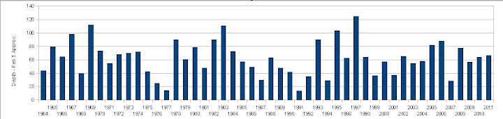
I was knee high to a grass hopper in the 70's... so you do the math there. But I guess those were
drought times. Can you conclude this by early Feb data?
Definitely you can see there are puny years following large years from just Feb. data.
But I think it's too early to worry too much...
As I mentioned in a different thread ...last year we had very little snow from mid-Jan to mid-Feb -ish..
and it wasn't looking that great... then we got dumped on seriously...
and then Jerry Brown declared the drought over... so let's eat cake.
(but yeah, I was looking forward to snow shoeing up on Watkins this Xmas.. and nixed that trip and
went to Kibbie instead... so it's just goofy)
(and if we get the same weather this year as last in the next month... yikes)
Anyway, just my opinion...

Using cdec I did a little plot of Feb Snow Depth at Dana Mdws and got this:
I was knee high to a grass hopper in the 70's... so you do the math there. But I guess those were
drought times. Can you conclude this by early Feb data?
Definitely you can see there are puny years following large years from just Feb. data.
But I think it's too early to worry too much...
As I mentioned in a different thread ...last year we had very little snow from mid-Jan to mid-Feb -ish..
and it wasn't looking that great... then we got dumped on seriously...
and then Jerry Brown declared the drought over... so let's eat cake.
(but yeah, I was looking forward to snow shoeing up on Watkins this Xmas.. and nixed that trip and
went to Kibbie instead... so it's just goofy)
(and if we get the same weather this year as last in the next month... yikes)
Anyway, just my opinion...
|
Re: Sierra Weather December 31, 2011 10:17AM | Registered: 14 years ago Posts: 1,491 |
Yep--76 and 77 were the last big drought years in California. Made a huge impact on the wine business, among other things !
Check our our website: http://www.backpackthesierra.com/
Or just read a good mystery novel set in the Sierra; https://www.amazon.com/Danger-Falling-Rocks-Paul-Wagner/dp/0984884963
Check our our website: http://www.backpackthesierra.com/
Or just read a good mystery novel set in the Sierra; https://www.amazon.com/Danger-Falling-Rocks-Paul-Wagner/dp/0984884963
December 31, 2011 10:44AM | Moderator Registered: 16 years ago Posts: 1,942 |
I am less impressed with the mild climate as the apparent variation from last year. Normally there is regression to the mean, but this is a dramatic change methinks.However. this mild climate is present through many parts of the country after a record year of precipitation, so perhaps it is not really a Sierra anomaly.Quote
balzaccom
Yep--76 and 77 were the last big drought years in California. Made a huge impact on the wine business, among other things !
Have there been many years when Tioga Pass Road has been open in December? Perhaps that is what I find so remarkable.
The cure for a fallacious argument is a better argument, not the suppression of ideas.
-- Carl Sagan
|
Re: Sierra Weather December 31, 2011 06:02PM | Registered: 13 years ago Posts: 35 |
I was living in Wawona in Feb. of 76.The drought presented opportunities to be taken advantage of.High country lake ice skating,hiking from Wawona to the valley and not seeing a soul,trips to the Snow Creek cabin with fresh veggies for Jeff and Nadim who were wintering there.It was a good year.
|
Re: Sierra Weather December 31, 2011 06:31PM | Registered: 14 years ago Posts: 1,986 |
Found this on www.monobasinresearch.org
Dec/Jan closing dates for Tioga Pass
1976 - Dec 29
1995 - Dec 11
1999/2000 Jan 1, 2000
Yearly precipitation data recording in California starts on July 1st and ends the following June 30th so I think it is too early in the recording year to determine what the final amount will be. With the current weather pattern, I doubt that the snow amounts in Yosemite will be the same as last winter. Anyway last year's snow totals was unusual. As for being a mild winter, there might have not been much snow but the daily temperatures, until the past week, have been much colder in Oct and Nov than usual in Yosemite West according to some people we know there.
We were in Yosemite for three days this week and it was really strange to be on Tioga Rd and not see much snow. We did spend some time Thursday walking on Tenaya Lake which will probably be a once in a lifetime thing for us. At sunset we were at Tioga Pass and with the wind blowing, it was cold. On the way back to the Valley we stopped again at Tenaya Lake and were the only people around so there was not much noise and we could hear the ice on Teneya Lake making a weird sound. The ice must have been expanding.
While we were on the lake the rangers came and posted signs that said: " Danger. Yosemite National Park recommends that you do not go on the ice." but they did not make anyone leave.
|
Re: Sierra Weather December 31, 2011 06:45PM | Registered: 16 years ago Posts: 384 |
I've always been fascinated by weather information. Sierra winter precipitation varies greatly:
http://gator1314.hostgator.com/~bestsnow/
select; California
"California's most distinguishing feature is the highest variability in snowfall of any region in the West. The late 80's to early 90's drought included two seasons, 1987 and 1991, when there was virtually no natural snow on the ground by New Year's Day."
The only long term annual snowfall records are for Central Sierra Snow Lab near Donner Summit:
http://www.thestormking.com/Weather/Sierra_Snowfall/sierra_snowfall.html
These Mammoth Mountain stats are the most interesting graphics, especially the colored monthly table:
http://www.skimountaineer.com/CascadeSki/CascadeSnow/MammothMtnSnowfall.gif
During the 1976/1977 drought I backpacked up Bear Creek between the Diversion Dam and Kip Camp early August and could jump across the creek with pack on at several spots.
The winter of 1989/1990 was the next most dramatic also with no snow in December.
Winters where the light blue is lowest on the chart had the driest starts like this winter and there were several.
Notice the amazing following winter of 1990/1991. As dry as 1976/1977 through February and then continuous storms in "The Miracle March". That spring that finally brought to the end, the six year drought, also had some of the most fantastic spring wildflowers.
In the Southern Sierra, the two largest storms in my lifetime were in Feb 1986 and Feb 1998.
The former in Feb 1986 lasting 11 days and causing huge floods in north bay areas of SF Bay caused the most high country avalanches that are still visible as old log piles in the High Sierra backcountry. One of those avalanches still visible roadside is between Tenaya Lake and Pywiak Dome. That avalanche actually ran all across the now soggy meadow clearing swaths of lodgepoles and then ran up above the road some height on Poly Dome. Also caused the old avalanche debris still decaying about Tioga Meadow. And to the east an avalanche coming down from the Mount Warren plateau went across US395 onto the shore of Mono Lake. I actually saw remains of the latter debris as we skied Mammoth Mountain the following weekend.
The latter in Feb 1998 storms caused that amazing flood through Yosemite Valley leaving that incredible high water mark at Valley View. That occurred during the period the Monterey office of the NWS began showing on the early Internet, continuous loop radar graphics of rainfall. I watched that graphic mesmerized as the main front in the Pacific approached Monterey County shores, I have never since seen as yellow and red displays. It washed out many large bridges in Monterey County and San Benito County, flooded the northern San Joaquin Valley areas before crossing the valley into the Yosemite region.
What is considered the snowiest location in California does not have a weather station so no records are available. That is Lassen Peak. Some may expect Shasta to be snowier because it is further north and higher. However Shasta is in a minor rain shadows of the lower Klamath Mountains to its southwest while Lassen just has relatively low coastal mountains to its southwest.
http://www.davidsenesac.com
Edited 3 time(s). Last edit at 12/31/2011 06:55PM by DavidSenesac.
December 31, 2011 08:22PM | Registered: 15 years ago Posts: 1,634 |
December 31, 2011 08:41PM | Registered: 16 years ago Posts: 4,174 |
December 31, 2011 09:04PM | Registered: 15 years ago Posts: 1,634 |
The answers to all those questions can be found here; Intergovernmental Panel on Climate Change. Or here. Or just about any science based website.Quote
plawrence
Just curious, by what metrics will this prediction be validated, or invalidated by? For the prediction above, what exactly constitutes a "weather event"?
December 31, 2011 09:44PM | Registered: 16 years ago Posts: 4,174 |
Quote
Dave
Quote
plawrence
Just curious, by what metrics will this prediction be validated, or invalidated by? For the prediction above, what exactly constitutes a "weather event"?
The answers to all those questions can be found here; Intergovernmental Panel on Climate Change. Or here. Or just about any science based website.
Thanks, I found the first link to the IPCC website to be useful.
Here's the definition of a "Extreme Weather or Climate Event" from their website: "The occurrence of a value of a weather or climate variable above (or below) a threshold value near the upper (or lower) ends of the range of observed values of the variable."
But according to the IPCC, they predict that in the 21st Century there will be MORE, not less, weather events of extreme heat and of heavy precipitation.
January 01, 2012 12:57PM | Registered: 15 years ago Posts: 1,634 |
Yes, more weather "events". I was specifically talking about rain events. Last year, here in Calif, we had more days of heavy precipitation and fewer days of light precip. Here's another link that explains it.Quote
plawrence
But according to the IPCC, they predict that in the 21st Century there will be MORE, not less, weather events of extreme heat and of heavy precipitation.
January 01, 2012 07:23PM | Registered: 16 years ago Posts: 4,174 |
December 31, 2011 08:29PM | Registered: 16 years ago Posts: 4,174 |
Quote
DavidSenesac
The latter in Feb 1998 storms caused that amazing flood through Yosemite Valley leaving that incredible high water mark at Valley View.
Just an FYI: the high water mark at Valley View was caused by the great New Years Day flood of 1997.
http://www.nature.nps.gov/yearinreview/yr_rvw97/chapter05/chapter05_a01.html
and
|
Re: Sierra Weather December 31, 2011 08:39PM | Registered: 14 years ago Posts: 50 |
Quote
DavidSenesac
The only long term annual snowfall records are for Central Sierra Snow Lab near Donner Summit:
http://www.thestormking.com/Weather/Sierra_Snowfall/sierra_snowfall.html
Thanks for this great info and commentary! I'm also a bit of a Sierra winter weather buff. I'm anxious to start reading through Mark McLaughlin's books (from 'the storm king' webpage).
|
Re: Sierra Weather January 09, 2012 04:38PM | Registered: 15 years ago Posts: 696 |
1986 was a big year for a winter/spring storm though. There was avalanche damage on the approach to Donahue Pass...had to climb over many downed trees. Since then, the trail has been rerouted and also rebuilt on the other side of Donahue (lots of steps on either side.) And the bridge at Woods Creek was washed out that year, as was a lot of the local real estate in that area. (Did the JMT that year.)
Ha, my first Sierra backpack was from Bear Division Dam to the Lake Italy area in 1976. Dry, but I didn't really know any difference at that point in my hiking career.
Edit: The placement of this post didn't quite end up where I planned...David I was commenting on your post about Feb 1986...
Edited 2 time(s). Last edit at 01/09/2012 04:42PM by hikerchick395.
|
Re: Sierra Weather December 31, 2011 09:54PM | Registered: 16 years ago Posts: 384 |
Thanks Plawrence, indeed my vague recollection on dates for that event(s) was way off, haha. The Yosemite Flood was December 31, 1996 and the Monterey County floods were a year before on March 13, 1995. These are wikipida snippets:
http://en.wikipedia.org/wiki/Floods_in_California
New Year's Day 1997: Northern California floodA series of subtropical storms, collectively called a pineapple connection, struck northern California from late December 1996 to early January 1997. December 1996 was one of the wettest Decembers on record. The Klamath River on California's North Coast experienced significant flooding which led to the river permanently changing course in some areas. The Klamath National Forest experienced its worst flood since 1974. Unprecedented flows from rain surged into the Feather River basin while melted snow surged into the San Joaquin River basin. Rain fell at elevations up to 11,000 feet (3,400 m), prompting snow melt. The Cosumnes River, a tributary to the San Joaquin River, bore the brunt of the flooding. Sacramento was spared, though levee failures flooded Olivehurst, Arboga, Wilton, Manteca, and Modesto. Massive landslides in the Eldorado National Forest east of Sacramento closed Highway 50. Damages totaled US$35 million (1997 dollars).
Watersheds in the Sierra Nevada were already saturated by the time three subtropical storms added more than 30 inches (760 mm) of rain in late December 1996 and early January 1997. Levee failures due to breaks or overtopping in the Sacramento River Basin resulted in extensive damages. In the San Joaquin River Basin, dozens of levees failed throughout the river system and produced widespread flooding. The Sacramento-San Joaquin River Delta also experienced several levee breaks and levee overtopping. 48 counties were declared disaster areas, including all 46 counties in northern California. Over 23,000 homes and businesses, agricultural lands, bridges, roads and flood management infrastructures – valued at about $2 billion – were damaged. Nine people were killed and 120,000 people were evacuated from their homes.[1] 300 square miles (780 km2) were flooded, including the Yosemite Valley, which flooded for the first time since 1861-62.
No doubt the Sierra Nevada's greatest historical storm occurred at a time before winterized roads when no one was there to witness it.
December 1861 - January 1862: California's Great FloodBeginning on December 24, 1861, and lasting for 45 days, the largest flood in California's recorded history was created, reaching full flood stage in different areas between January 9-12, 1862. The entire Sacramento and San Joaquin valleys were inundated for an extent of 300 miles (480 km), averaging 20 miles (32 km) in breadth. State government was forced to relocate from the capital in Sacramento for 18 months in San Francisco. The rain created an inland sea in Orange County, lasting about three weeks with water standing 4 feet (1.2 m) deep up to 4 miles (6 km) from the river.[1] The Los Angeles basin was flooded from the San Gabriel Mountains to the Palos Verdes Peninsula, at varible depths, excluding the higher lands which became islands until the waters receded. The Los Angeles basin lost 200,000 cattle by way of drowning, as well as homes, ranches, farm crops & vineyards being swept-away.
http://www.davidsenesac.com
|
Re: Sierra Weather January 03, 2012 09:54AM | Registered: 16 years ago Posts: 118 |
I don't know the statistics on Yosemite, but in San Francisco, for example, it had its driest Decembers in 1876 and 1989 with no rain. So in the bay area it has been this dry before. I was reading the NWS forecast discussion last Friday December 30, and this is what the forecaster at the San Francisco Bay Area/Monterey office had to say about it:
From http://www.wrh.noaa.gov/total_forecast/getprod.php?afos=xxxafdmtr&wfo=mtr&version=25
DRIER THAN NORMAL CONDITIONS ARE
TYPICAL OF A COMBINED LA NINA AND NEGATIVE PHASE OF THE PDO WHICH
WE HAVE BEEN IN NOW FOR SEVERAL YEARS. LAST YEAR WAS VERY MUCH AN
ANOMALY AS THE STRENGTH OF THE LA NINA ALLOWED THE LONG WAVE
TROUGH TO BE SLIGHTLY WEST OF WHERE IT IS THIS YEAR AND PUT CA IN
A SEMI-PERMANENT TROUGH. WITH A WEAKER LA NINA AND NEGATIVE PDO
BELOW NORMAL PRECIPITATION IS TYPICAL. WE SAM THIS FOR A MAJORITY OF
THE YEARS IN THE 50S AND 60S EXTENDING INTO THE EARLY 70S.
ALTHOUGH THE MJO APPEARS TO BE ACTIVE RIGHT NOW AND HAS SHOWN
SIGNS OF ACTIVITY OVER THE PAST TWO MONTHS IN REALITY IT APPEARS
TO BE MORE RELATED TO PERIODIC KELVIN WAVES THE EXCITE THE
PERSISTENT LA NINA PATTERN AND THE MJO QUICKLY DIES OUT NEAR 120
TO 130E AND THEN CYCLES BACK INTO THE FAR WESTERN PACIFIC. ONLY IN
OCTOBER DID WE SEE A STRONG MJO IN THE INDIAN OCEAN THAT HELPED
RETROGRADE THE TROUGH BACK OFF THE WEST COAST WHICH GAVE US SOME
EARLY RAINS AND EVEN THESE WERE MOSTLY SOUTH.
SO WE MAY BE IN FOR MORE YEARS WITH BELOW NORMAL RAINFALL THAN
ABOVE NORMAL.
January 03, 2012 01:01PM | Admin Registered: 16 years ago Posts: 17,140 |
A Kelvin wave is a wave in the ocean or atmosphere that balances the Earth's Coriolis force against a topographic boundary such as a coastline, or a waveguide such as the equator. A feature of a Kelvin wave is that it is non-dispersive, i.e., the phase speed of the wave crests is equal to the group speed of the wave energy for all frequencies. This means that it retains its shape in the alongshore direction over time.
http://en.wikipedia.org/wiki/Kelvin_wave
http://en.wikipedia.org/wiki/Kelvin_wave
January 03, 2012 01:24PM | Registered: 16 years ago Posts: 1,882 |
Frank mentioned that it's been a rather mild season so far for much of the country, with possibly an exception in the midwest states. Having grown up in the east, mostly New England, I take great notice of the jet stream pattern. This year the jet stream trough has been more to the center of the country and tends to channel cross-country weather systems up through the Ohio Valley and western New York. A more traditional jet stream pattern in the winter is a trough further east which drives most weather systems up the east coast where they pick up a lot of moisture and proceed through New England dumping lots of snow. I confess I'm not familiar with how changes in the jet stream pattern affects the west coast and Sierra region but believe this has a lot to do with how much snow drops in the Sierra.
|
Re: Sierra Weather January 08, 2012 10:00PM | Registered: 14 years ago Posts: 44 |
Quote
rightstar76
I don't know the statistics on Yosemite, but in San Francisco, for example, it had its driest Decembers in 1876 and 1989 with no rain. So in the bay area it has been this dry before. I was reading the NWS forecast discussion last Friday December 30, and this is what the forecaster at the San Francisco Bay Area/Monterey office had to say about it:
From http://www.wrh.noaa.gov/total_forecast/getprod.php?afos=xxxafdmtr&wfo=mtr&version=25
DRIER THAN NORMAL CONDITIONS ARE
TYPICAL OF A COMBINED LA NINA AND NEGATIVE PHASE OF THE PDO WHICH
WE HAVE BEEN IN NOW FOR SEVERAL YEARS. LAST YEAR WAS VERY MUCH AN
ANOMALY AS THE STRENGTH OF THE LA NINA ALLOWED THE LONG WAVE
TROUGH TO BE SLIGHTLY WEST OF WHERE IT IS THIS YEAR AND PUT CA IN
A SEMI-PERMANENT TROUGH. WITH A WEAKER LA NINA AND NEGATIVE PDO
BELOW NORMAL PRECIPITATION IS TYPICAL. WE SAM THIS FOR A MAJORITY OF
THE YEARS IN THE 50S AND 60S EXTENDING INTO THE EARLY 70S.
ALTHOUGH THE MJO APPEARS TO BE ACTIVE RIGHT NOW AND HAS SHOWN
SIGNS OF ACTIVITY OVER THE PAST TWO MONTHS IN REALITY IT APPEARS
TO BE MORE RELATED TO PERIODIC KELVIN WAVES THE EXCITE THE
PERSISTENT LA NINA PATTERN AND THE MJO QUICKLY DIES OUT NEAR 120
TO 130E AND THEN CYCLES BACK INTO THE FAR WESTERN PACIFIC. ONLY IN
OCTOBER DID WE SEE A STRONG MJO IN THE INDIAN OCEAN THAT HELPED
RETROGRADE THE TROUGH BACK OFF THE WEST COAST WHICH GAVE US SOME
EARLY RAINS AND EVEN THESE WERE MOSTLY SOUTH.
SO WE MAY BE IN FOR MORE YEARS WITH BELOW NORMAL RAINFALL THAN
ABOVE NORMAL.
Thanks for teling us about Kelvin Waves...what is PDO and MJO?
January 09, 2012 03:33AM | Admin Registered: 16 years ago Posts: 17,140 |
Pacific Decadal Oscillation
(Abbrev. PDO) - a recently described pattern of climate variation similar to ENSO though on a timescale of decades and not seasons. It is characterized by SST anomalies of one sign in the north-central Pacific and SST anomalies of another sign to the north and east near the Aleutians and the Gulf of Alaska. It primarily affects weather patterns and sea surface temperatures in the Pacific Northwest, Alaska, and northern Pacific Islands.
Madden-Julian Oscillation
(abbrev. MJO)- Tropical rainfall exhibits strong variability on time scales shorter than the seasonal El Niño-Southern Oscillation (ENSO). These fluctuations in tropical rainfall often go through an entire cycle in 30-60 days, and are referred to as the Madden-Julian Oscillation or intraseasonal oscillations. The intraseasonal oscillations are a naturally occurring component of our coupled ocean-atmosphere system. They significantly affect the atmospheric circulation throughout the global Tropics and subtropics, and also strongly affect the wintertime jet stream and atmospheric circulation features over the North Pacific and western North America. As a result, they have an important impact on storminess and temperatures over the United States. During the summer these oscillations have a modulating effect on hurricane activity in both the Pacific and Atlantic basins.
|
Re: Sierra Weather January 09, 2012 09:38PM | Registered: 13 years ago Posts: 2 |
Well, Frankenfurter (I am not Rocky), in February of 1977 my constant rock climbing buddy and I drove over Tioga Pass and there was no snow in the high country. We climbed a few routes on the granite spires/domes surrounding Tuolumne Meadows, then we cranked it to Dana's summit. Then we drove down to 395 and spent a couple of au natural days at Hot Creek before driving back up over Tioga. Oh, did I say that was mid-February?
But what about the paleo-drought that lasted 40 years over 300 years ago. Tahoe dropped over 40 feet from its standard annual level. Indians ground their acorns on granite shelves that are now covered by over 30 feet of water.
Now imagine a 40-year drought hitting California today. 300+ years ago there were maybe a few tens of thousands of primitive Indians who only used water for drinking and an occasional quick dip. Today with this state approaching 40-million water-wasting residents, a 40-year drought would result in the total collapse of California's collective industries (including agriculture) and there would be an emigration of historical dimensions.
None of these droughts are man-made in spite of the anthropogenic climate change hysteria. They are all directly related to ocean currents (ENSO, PDO, etc) which are loosely cyclical and therefore unavoidable.
|
Re: Sierra Weather January 10, 2012 12:09AM | Registered: 16 years ago Posts: 88 |
Quote
HighCountryJeff
None of these droughts are man-made in spite of the anthropogenic climate change hysteria. They are all directly related to ocean currents (ENSO, PDO, etc) which are loosely cyclical and therefore unavoidable.
Always entertaining when lay people voice their "opinion" on a scientific matter when they have little or no educational background in the field, have done no scientific research of their own and have not published any papers in peer reviewed scientific journals. Sort of like getting your news from talk radio. Who cares what you think. Global warming may still be a debatable issue (well, not really), but I prefer to listen to the arguments of those who have actually studied the issue.
January 10, 2012 05:14AM | Moderator Registered: 16 years ago Posts: 1,942 |
Quote
LVRAY
Quote
HighCountryJeff
None of these droughts are man-made in spite of the anthropogenic climate change hysteria. They are all directly related to ocean currents (ENSO, PDO, etc) which are loosely cyclical and therefore unavoidable.
Always entertaining when lay people voice their "opinion" on a scientific matter when they have little or no educational background in the field, have done no scientific research of their own and have not published any papers in peer reviewed scientific journals. Sort of like getting your news from talk radio. Who cares what you think. Global warming may still be a debatable issue (well, not really), but I prefer to listen to the arguments of those who have actually studied the issue.
Rational behavior has never been easy for us higher apes-- that is way we have politics and religion.
The cure for a fallacious argument is a better argument, not the suppression of ideas.
-- Carl Sagan
Edited 1 time(s). Last edit at 01/10/2012 05:20AM by Frank Furter.
|
Re: Sierra Weather January 09, 2013 06:05AM | Registered: 13 years ago Posts: 2 |
That's fairly presumptuous of you to think I have not thoroughly studied this topic. I know more about the REAL SCIENCE being climate variability/changes than you probably do. One of my closest pals is the leading British climate scientist Peter Taylor, author of "Chill: A Reassessment of Global Warming Theory" (2009). Read his book, the seminal treatise on climate science and the ignorance-driven hysteria driving the debate. Like lemmings to the sea, fueled with the blind allegiance to mythology -- not unlike religious fervor -- the AGW supplicants, sycophants, and toadies worship at the altar of pseudo-scientific dogma. It's politically correct chic to be pro-AGW, looks good on your social networking bio, gets you into the right parties. But in the wings true science weeps!!
January 09, 2013 10:05AM | Moderator Registered: 15 years ago Posts: 1,634 |
Interesting.... I didn't know that knowing someone that wrote a book makes you an expert in that field? That makes me an expert in geology, psychology, and art. I also didn't know that ONE book, not peer reviewed, cancels out all the facts and science that tells us otherwise.Quote
HighCountryJeff
That's fairly presumptuous of you to think I have not thoroughly studied this topic. I know more about the REAL SCIENCE being climate variability/changes than you probably do. One of my closest pals is the leading British climate scientist Peter Taylor, author of "Chill: A Reassessment of Global Warming Theory" (2009). Read his book, the seminal treatise on climate science and the ignorance-driven hysteria driving the debate. Like lemmings to the sea, fueled with the blind allegiance to mythology -- not unlike religious fervor -- the AGW supplicants, sycophants, and toadies worship at the altar of pseudo-scientific dogma. It's politically correct chic to be pro-AGW, looks good on your social networking bio, gets you into the right parties. But in the wings true science weeps!!
January 09, 2013 09:57AM | Moderator Registered: 15 years ago Posts: 1,634 |
They're just doing what their Regressive politicians, in the pay of the oil companies, are telling them to do.Quote
LVRAY
Always entertaining when lay people voice their "opinion" on a scientific matter when they have little or no educational background in the field, have done no scientific research of their own and have not published any papers in peer reviewed scientific journals. Sort of like getting your news from talk radio. Who cares what you think. Global warming may still be a debatable issue (well, not really), but I prefer to listen to the arguments of those who have actually studied the issue.
January 09, 2013 09:55AM | Moderator Registered: 15 years ago Posts: 1,634 |
Those past droughts have nothing to do with the reality of climate change today. It makes no sense to even try and link the two entirely different events. The increase of atmospheric CO2 by about 100ppm (a one third increase) is what matters. Not droughts long ago. The change in the ratio of carbon 12 to carbon 13 in our atmosphere tells us that increase is caused by the burning of fossil fuels.Quote
HighCountryJeff
...None of these droughts are man-made in spite of the anthropogenic climate change hysteria. They are all directly related to ocean currents (ENSO, PDO, etc) which are loosely cyclical and therefore unavoidable.
Sorry, only registered users may post in this forum.

