I was just wasting time, looking at some maps, and noticed that a maintained dirt road, the Sky Ranch Road, goes practically up to the southern park border, and read a report that from the parking spot/trailhead it's a scant 3/4 miles up to Chiquito pass, and, consequently, all sorts of delicious backcountry goodness treats like Ottoway Lakes, Chain Lakes, Spotted Lakes, etc...
That said....
A. Has anyone taken this route in?
B. How was the condition of the road (my fun times vehicle is a 4wd Jeep Liberty, so other than hardcore rock hopping, roads are usually not an issue)
C. Is it really that close to the pass itself?
D. If you've been, what are some of the highlights? I've heard there's a 'Clark Range Circuit' of about 5 easy-going days, but my primary interest is, of course, photography.
Anyone? Buehler?

The Moon is Waning Gibbous (59% of Full)
Re: Quartz Mountain trailhead through Chiquito Pass?
All posts are those of the individual authors and the owner
of this site does not endorse them. Content should be considered opinion
and not fact until verified independently.
|
Quartz Mountain trailhead through Chiquito Pass? March 23, 2012 09:27AM | Registered: 14 years ago Posts: 409 |
March 23, 2012 09:42AM | Registered: 13 years ago Posts: 1,351 |
I've used that trailhead, for a Red Peak Pass/Post Peak Pass loop. Its extremely beautiful up there, I'll have to see if I have a few pictures this evening.
The road is fine for cars as long as nobody's doing construction on it...on my way out they were rebuilding the base without having closed it and I found my Subie going over big rocks for a short stretch. But the normal state of the road is fine for cars, first part is paved, most of the rest is gravel. The final turn to the trailhead (short dirt stretch, no real problem) wasn't signed when I was there, so watch for it.
It is really that close to the pass, and in fact you go down slightly to the pass. No views at the pass itself, its all forested. The good stuff is beyond.
Wilderness permits are from Sierra NF, I picked up the permit from a drop box just north of Oakhurst.
Edited 1 time(s). Last edit at 03/23/2012 09:46AM by ttilley.
|
Re: Quartz Mountain trailhead through Chiquito Pass? March 23, 2012 09:55AM | Registered: 14 years ago Posts: 409 |
Quote
ttilley
I've used that trailhead, for a Red Peak Pass/Post Peak Pass loop. Its extremely beautiful up there, I'll have to see if I have a few pictures this evening.
The road is fine for cars as long as nobody's doing construction on it...on my way out they were rebuilding the base without having closed it and I found my Subie going over big rocks for a short stretch. But the normal state of the road is fine for cars, first part is paved, most of the rest is gravel. The final turn to the trailhead (short dirt stretch, no real problem) wasn't signed when I was there, so watch for it.
It is really that close to the pass, and in fact you go down slightly to the pass. No views at the pass itself, its all forested. The good stuff is beyond.
Wilderness permits are from Sierra NF, I picked up the permit from a drop box just north of Oakhurst.
Most excellent, being able to drive up that high and just jump into the backcountry.
So it's sort of like a Horseshoe Meadows of the west side, I take it.
March 23, 2012 07:18PM | Registered: 13 years ago Posts: 1,351 |
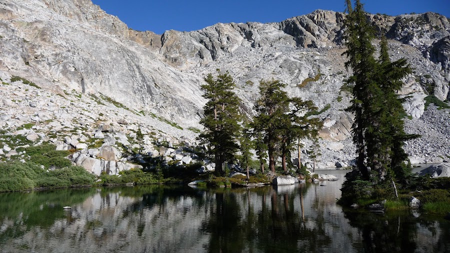
I posted some pictures from a August 2008 trip here: Pictures Here
A few of them: first, Lower Ottoway Lake from near campsite:

Upper Ottoway from Red Peak Pass:

Red Devil Lake, other side of that pass:
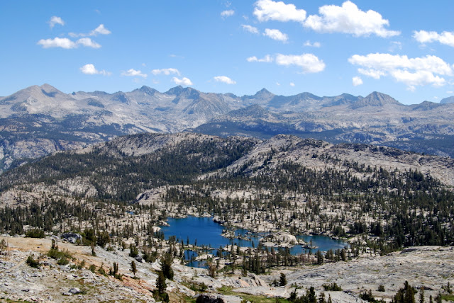
Middle Chain Lake:

A few of them: first, Lower Ottoway Lake from near campsite:
Upper Ottoway from Red Peak Pass:
Red Devil Lake, other side of that pass:
Middle Chain Lake:
|
Re: Quartz Mountain trailhead through Chiquito Pass? March 23, 2012 10:09AM | Registered: 15 years ago Posts: 923 |
The dirt part of the road is really dirty. Close all the vents if it's dry. If you go in hunting season brace yourself - the jeeps with rifle barrels sticking out will be flying down those roads, causing great clouds of dust that you end up stopping and waiting for them to settle....
Chain Lakes is a real nice first night out. Beautiful area.
Chain Lakes is a real nice first night out. Beautiful area.
March 23, 2012 10:26AM | Registered: 14 years ago Posts: 7,421 |
Take a look at this:
http://yosemitenews.info/forum/read.php?3,28637
and this:
http://yosemitenews.info/forum/read.php?3,27226
On the second link there is talk of Globe Rock and I also put a map to Quartz Mtn TH.
Sky Ranch is the painful way to go in. I've come out that way once... and vowed to
make all attempts to avoid that way in or out in the future.
Broken record... ya ya... but yeah, I've done a number of trips from that TH and
done the "5 Pass Loop" in 3 days... Chiquito->Fernandez->Post->Red->Merced
Lots of great great stuff to explore...
Check out this one too:
http://yosemitenews.info/forum/read.php?3,41516,45481#msg-45481
Have fun
March 23, 2012 10:46AM | Registered: 14 years ago Posts: 7,421 |
Check this one out too:
http://yosemitenews.info/forum/read.php?3,28614
This trip was from Quartz.
Day 1 was by all Chain Lakes and to Breeze and up Fernandez Pass and back down with Old Dude
Day 2 was the pictures you see in that thread... and back around to Givens via Red Peak / Merced Pass
Day 3 was out
So... obviously a lot can be seen and explored from Quartz TH.
Have fun
|
Re: Quartz Mountain trailhead through Chiquito Pass? March 23, 2012 11:28AM | Registered: 14 years ago Posts: 409 |
Quote
chick-on
Check this one out too:
http://yosemitenews.info/forum/read.php?3,28614
This trip was from Quartz.
Day 1 was by all Chain Lakes and to Breeze and up Fernandez Pass and back down with Old Dude
Day 2 was the pictures you see in that thread... and back around to Givens via Red Peak / Merced Pass
Day 3 was out
So... obviously a lot can be seen and explored from Quartz TH.
Have fun
Ah, yes! Edna Lake and that funky island!
That sounds like a nice littl 3 dayer.
|
Re: Quartz Mountain trailhead through Chiquito Pass? March 24, 2012 06:06PM | Registered: 13 years ago Posts: 44 |
What is the nearest town or highway to the Sky Ranch road turn off and how long does it take to get to the TH from that point? What about Granite TH? We are thinking of going into that area this summer and know very little about the roads and such in the area you are discussing. We are considering entering via mono meadows or DPP but would like to explore new areas.
March 25, 2012 08:31AM | Registered: 14 years ago Posts: 7,421 |
a) OakhurstQuote
riverkat
What is the nearest town or highway to the Sky Ranch road turn off and how long does it take to get to the TH from that point? What about Granite TH? We are thinking of going into that area this summer and know very little about the roads and such in the area you are discussing. We are considering entering via mono meadows or DPP but would like to explore new areas.
b) Figure an hour (I'm sure I've done it in much less tho... but sometimes I drive like a BOH)
c) Longer... to get to Clover Meadow is more delicious than Quartz
Here's the map you can get at Oakhurst NF Visitor Center where you can get your permit:

This is the preferred route in.
For Clover Meadow area they may give you this map:

I guess by Granite he means Isberg. At least that is the TH I have taken...
You can find great maps of THs here:
http://www.fs.fed.us/r5/forestvisitormaps/
It's what I have used in the past to plan things. Some really great maps. Tried to get the closedcontour guy to add TH to his maps... but I guess not.
You can also pick up something like NG Maps which have the THs on them. For this case Yosemite SE / Ansel Adams Wilderness (#309).
I pick up the NF maps when I'm in there though. They are really sweet.... or you can make them yourself from the link above.
ala:

Also on the NF sites you can find OHV maps. Look at those at you'll get a headache and/or a "are you kidding me?" moment.
Have fun exploring... there's enough out there to keep you busy a very very long time...
For those that don't hike a lot or backpack... the Sierra Scenic Vista Byway is really nice and worth exploring.
More or less it links Sky Ranch + Beasore Rd. with Minarets Rd. Things like the Mile High Vista, Ross Cabin, and
Globe Rock are little gems.
March 25, 2012 08:37AM | Registered: 14 years ago Posts: 7,421 |
One other note... these roads may be windy and unpaved in portions...
but they do not go over any mountain passes. The crest is
(or should I say... the San Joaquin Canyon) still east of "the road end" .
These THs are worthwhile to explore... just be aware they are quota THs
and do fill up. Day 1 into Harriet Lake in Yosemite... ahhh...
(YMMV)
but they do not go over any mountain passes. The crest is
(or should I say... the San Joaquin Canyon) still east of "the road end" .
These THs are worthwhile to explore... just be aware they are quota THs
and do fill up. Day 1 into Harriet Lake in Yosemite... ahhh...
(YMMV)
March 25, 2012 11:39AM | Registered: 15 years ago Posts: 4,173 |
March 25, 2012 01:41PM | Registered: 14 years ago Posts: 7,421 |
My particular sample size is actually not that big... def. not for the busy summer months.
I've been at a couple of the THs later in the year and been the only car though.
In summer I'm certain places like Granite Crk/Isberg will be very very full... there's just
too many lakes that are close to the TH.
I never worry about parking though. I don't think you should. You'll find something.
What Almost said about the hunting season is spot on. They even may stop you and
ask what you're doing. "I am NOT hunting! So why you stopping me? And please don't shoot me!"
|
Re: Quartz Mountain trailhead through Chiquito Pass? March 25, 2012 11:37AM | Registered: 13 years ago Posts: 44 |
Thanks so much for the time and trouble to provide us with a great response ... we printed out your email and added it to our "file" of places to go. This summer will be our first without children (we promise we didn't kill them.... they are actually graduating HS and going off on their own adventures) keeping us tied to the valley and we are chomping at the bit to get out and explore!
March 25, 2012 01:35PM | Registered: 14 years ago Posts: 7,421 |
U R Welcome.
If you have not seen these links you may be interested:
http://yosemitenews.info/forum/read.php?3,28062
and P's trip report
http://yosemitenews.info/forum/read.php?3,46185
If you want actual jpg's of any of this stuff... just hollar
If you have not seen these links you may be interested:
http://yosemitenews.info/forum/read.php?3,28062
and P's trip report
http://yosemitenews.info/forum/read.php?3,46185
If you want actual jpg's of any of this stuff... just hollar
March 23, 2012 11:31AM | Registered: 15 years ago Posts: 4,173 |
Quote
tanngrisnir3
B. How was the condition of the road (my fun times vehicle is a 4wd Jeep Liberty, so other than hardcore rock hopping, roads are usually not an issue)
Slightly off tangent, how do you like your 4WD Jeep Liberty? What year is it?
That's a vehicle I've been thinking of purchasing in the past for backroads traveling, but I've heard and read mix reports on it so I have shied away from it in the past. Has it been reliable? No major mechanical issues?
.
|
Re: Quartz Mountain trailhead through Chiquito Pass? March 23, 2012 12:14PM | Registered: 14 years ago Posts: 409 |
Quote
plawrence
Quote
tanngrisnir3
B. How was the condition of the road (my fun times vehicle is a 4wd Jeep Liberty, so other than hardcore rock hopping, roads are usually not an issue)
Slightly off tangent, how do you like your 4WD Jeep Liberty? What year is it?
That's a vehicle I've been thinking of purchasing in the past for backroads traveling, but I've heard and read mix reports on it so I have shied away from it in the past. Has it been reliable? No major mechanical issues?
.
Love it. Bought it used, at 97,000. Top level of the three (Sport, Renegade then 'Limited') and 'trail-rated' so it's 4wd. It's got leather, power everything, and the good thing was the original owner opted for all the harder core off road things like skid plates, tow package (good for tranny cooler and bigger radiator, even if you don't tow at all), etc... It's a 2007, the last year they made what's known as the KJ style, before they went to the currently produced KK style, which is boxier and uglier (IMO).
Zero mechanical issues whatsoever (I've owned three jeeps, all have been bulletproof)
The best bang for the buck out there for second vehicle, off road advernture stuff is the Jeep Cherokee Sport with that all-time great straight 6 4.0L engine. It could climb walls if it had to, but they feel really light. The first time you open/shut one of their doors, you'll know what I mean.
March 23, 2012 12:32PM | Registered: 15 years ago Posts: 4,173 |
|
Re: Quartz Mountain trailhead through Chiquito Pass? March 24, 2012 07:06AM | Registered: 13 years ago Posts: 1,447 |
As an alternative, we have a Ford Escape Hybrid that we are VERY happy with, 75K miles on it without a problem. And it gets 33-34 mpg. We liked the ride of this car a lot better than the jeep's.
And to bring this back to the original topic, we drove it to Granite Creek trailhead so that we could take a trip from there up to Isberg Post Peak Passes last summer...
here is a photo, and a link to the photo log:

https://picasaweb.google.com/balzaccom/AnselAdamsWilderness2011#
Check our our website: http://www.backpackthesierra.com/
Or just read a good mystery novel set in the Sierra; https://www.amazon.com/Danger-Falling-Rocks-Paul-Wagner/dp/0984884963
And to bring this back to the original topic, we drove it to Granite Creek trailhead so that we could take a trip from there up to Isberg Post Peak Passes last summer...
here is a photo, and a link to the photo log:
https://picasaweb.google.com/balzaccom/AnselAdamsWilderness2011#
Check our our website: http://www.backpackthesierra.com/
Or just read a good mystery novel set in the Sierra; https://www.amazon.com/Danger-Falling-Rocks-Paul-Wagner/dp/0984884963
March 24, 2012 08:26AM | Registered: 14 years ago Posts: 7,421 |
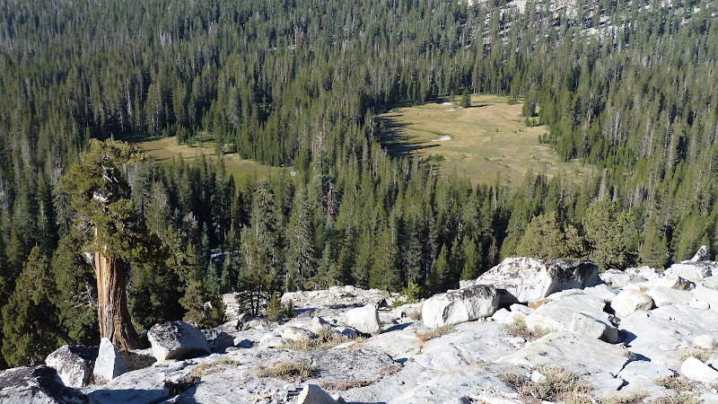
Here's a few more since you asked about lakes on another thread.
Upper Chain:

Breeze:

With the cirque on the south the lighting is trickier with these lakes. I like the Breeze one alot b/c it brings back
memories of crank calling with brothers and sisters "Do you have Sir Walter Raleigh in a can?" ... "well, can you let him out" .. click.
Good times. Was bummed couldn't find the can again on subsequent visits.
Givens is probably rated low by most

For me it's one of those things .. nice reflection... nice memories... so it's nice... first time went there climbed up to
Beuna Vista Crest which is reflected in the lake there...
And Givens Meadow view is gorgeous from near the lake:
Have fun exploring... there's a whole lot more out there...
Upper Chain:
Breeze:
With the cirque on the south the lighting is trickier with these lakes. I like the Breeze one alot b/c it brings back
memories of crank calling with brothers and sisters "Do you have Sir Walter Raleigh in a can?" ... "well, can you let him out" .. click.
Good times. Was bummed couldn't find the can again on subsequent visits.
Givens is probably rated low by most
For me it's one of those things .. nice reflection... nice memories... so it's nice... first time went there climbed up to
Beuna Vista Crest which is reflected in the lake there...
And Givens Meadow view is gorgeous from near the lake:
Have fun exploring... there's a whole lot more out there...
Sorry, only registered users may post in this forum.

