Welcome! Log In Create A New Profile Recent Posts
Yosemite Valley

The Moon is Waxing Gibbous (81% of Full)

JanSport


Advanced

Old Crane Flat Roads (and rail) (for DavidK)

All posts are those of the individual authors and the owner of this site does not endorse them. Content should be considered opinion and not fact until verified independently.

avatar Old Crane Flat Roads (and rail) (for DavidK)
February 08, 2013 07:56AM
When you drive in on 120... you probably notice the old roads zigging around
the current Big Oak Flat Road. Since I love the old maps, playing around with them,
and exploring this sort of thing ... here's an overlay map some may find of interest:
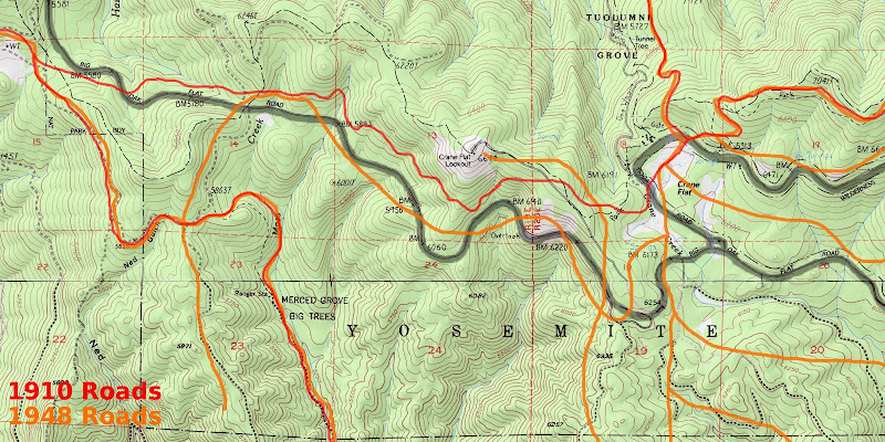


or bigger:
https://lh5.googleusercontent.com/-RvlsEkHgO-U/URUeufPOenI/AAAAAAAABiY/6MPgpuhBB7M/s1152/CraneFlat-Overlay-2.jpg

The older maps are somewhat crude. So you have to just take it as generally where
and how many roads there were. Someday I'll walk the old road you can see many times
around Merced Grove all the way, more or less, to Crane Flat... etc.
If you overlay the Yosemite Lumber company (that map is VERY crude)... then it gets
REALLY messy... well... I'm sure it got REAL messy all over this area... since the entire
area except some very small sections were cut.

Have a few other maps that will share in time.

Hope u Njoy


Chick-on is looking at you!


Edited 1 time(s). Last edit at 02/08/2013 07:57AM by chick-on.
Re: Old Crane Flat Roads (and rail) (for DavidK)
February 08, 2013 09:00AM
Thanks, chick-on! My first "trace-it-on-a-map" exercise was trying to follow the Coulterville Road from Coulterville all the way to the Valley (the whole road is still there and, as you probably know, more-or-less drivable as far as Big Meadow...although much of it requires a pretty high-clearance vehicle these days). When I got into the area approaching and entering the Park, where newer maps SHOW the old road but don't always label it as "Old Coulterville Road," I started getting into some of the spaghetti which your overlay begins to show (and yes, when you lay in the various forestry roads, some areas get very messy). That section's south of your map but you can see some of the "strands" on your map. (For anyone who aren't familiar with the lines of the old roads, The orange/red road which runs immediately left of the "MERCED GROVE" label is the Old Coulterville Road and the red road which is just north of the current BOFR on the left half of the map is the Old BOFR.)

I certainly don't have to tell you but much of that stretch is pretty easy to follow on the ground (as long as you know which way to go at the various intersections). One of the next stretches on my Old Roads To-Do List is Old Coulterville between Little Nellie Falls and Merced Grove...that's the one piece of that road within the current Park boundaries which I've not yet walked.


Edited 1 time(s). Last edit at 02/08/2013 09:08AM by DavidK42.
Re: Old Crane Flat Roads (and rail) (for DavidK)
February 08, 2013 02:06PM
David, I'm fairly certain that the red line to the north of modern Highway 120 on the left side of the map (and then crossing to the south side as you move toward the map's left edge) is not the Old BOF Road, but is the old connector/cutoff road that ran from the Coulterville Road at Hazel Green to the Old BOF Road at Crane Flat. This was originally constructed to be part of the Coulterville Road but was abandoned after being built in favor of a new alignment down through the recently discovered Merced Grove to Little Nellie Falls, Big Meadow, and the Cascades. In later years, this road was rehabilitated and used by stages and, later, cars as a way of getting from the CR to the BOF Road after both roads were taken over by Mariposa County and ceased to be toll facilities. I believe that this connector road was officially abandoned sometime in the 1950s when planning for the new Highway 120 was underway, although the owners of the Hazel Green Ranch in recent years have tried to make a case for it being a usable thoroughfare (I've walked it -- it's not) as part of their lawsuit attempting to force the Park Service to agree to providing access from their property to Highway 120 in the Park at the wide spot where 120 curves to the north in the map's upper left corner. The actual Old BOF Road ran north from Crane Flat down through Tuolumne Grove, not west to Hazel Green. There was no road along the modern Highway 120 alignment north of the Hazel Green pullout until that road was constructed in the early 1960s.


Edited 2 time(s). Last edit at 02/08/2013 02:08PM by Rob65.
Re: Old Crane Flat Roads (and rail) (for DavidK)
February 08, 2013 03:20PM
Oops...that's what I get for responding quickly while trying to pay attention to a conference call at work! eye rolling smiley I saw the part on the right that looked like it went off towards Gin Flat and then got totally sloppy about extrapolating in the other direction...of course the OBOFR went through Tuolumne Grove (and, as you've already pointed out, the alignment seems off on the overlay). Apparently I don't have all the old roads memorized as well as I like to think...Definitely need to get my feet on them more frequently!

Apologies for the misinformation confused smiley
Re: Old Crane Flat Roads (and rail) (for DavidK)
February 08, 2013 03:25PM
Hate it when work gets in the way of Yosemite talk. Or Yosemite visits...
avatar Re: Old Crane Flat Roads (and rail) (for DavidK)
February 08, 2013 11:07AM
Thanks for the link to this map. The map is awesome.


By the way, here's a neat trick one can to with jpegs posted on Picasa or Google+. One can enlarge (or shrink) the photos to a lot more sizes than Google defaults to by changing the URL of the photo. So the image of your map can be enlarged from the size you posted (1152 pixels wide) to an even larger 2400 pixels wide image just by changing the URL from:

https://lh5.googleusercontent.com/-RvlsEkHgO-U/URUeufPOenI/AAAAAAAABiY/6MPgpuhBB7M/s1152/CraneFlat-Overlay-2.jpg

to:
https://lh5.googleusercontent.com/-RvlsEkHgO-U/URUeufPOenI/AAAAAAAABiY/6MPgpuhBB7M/s2400/CraneFlat-Overlay-2.jpg

(Basically, changing the /s1152/ located in the URL to /s2400/ )


avatar Re: Old Crane Flat Roads (and rail) (for DavidK)
February 08, 2013 11:22AM
I posted s800... and gave link to s1152.
But thanks for telling everyone that little tip.
(and to get the link... just hit "quote" and you'll see the link text)


Chick-on is looking at you!


Edited 1 time(s). Last edit at 02/08/2013 11:22AM by chick-on.
Re: Old Crane Flat Roads (and rail) (for DavidK)
February 08, 2013 01:59PM
Thanks for the cool map. But I have some questions as the roads you've traced don't quite match up with my understanding of the old road system in the Crane Flat area. What is the red/orange line that goes off the top of the map on the right hand side? I'm not aware of any road in this location -- it looks as if it is supposed to be the OBOF Road through Tuolumne Grove, but due to a mapping error, it is shifted off to the east from its actual location (shown by a grey line on the base topo next to the "Tunnel Tree" label). Also, the alignment of the OBOF road heading toward Gin Flat from Crane Flat seems off as your map shows it intersecting the new Tioga Road much closer to Crane Flat than it actually does. I'm also not aware of the old road ever crossing the middle of the Crane Flat meadow the way the map shows it doing. The alignment of the old Crane Flat-Hazel Green road (originally built as part of the Coulterville Road but then abandoned after the discovery of Merced Grove and the subsequent re-routing of the CR through the Grove) also seems off, as I've always understood it to be the road you see many times crossing the modern Highway 120 between the Merced Grove parking area and Crane Flat junction, while your map shows it staying to the north of 120. I've walked the eastern part of this road beginning at the modern Tuolumne Grove parking lot and heading SW over to where it hits 120, and this road isn't shown at all on your map as either a red or orange line.

As an aside, a couple of years ago, I followed the westernmost portion of the old Crane Flat-Hazel Green road (which does show up correctly as the red line south of modern 120 in the upper left corner of your map) over to the park boundary and beyond to where it meets up with the Old Coulterville Road at Hazel Green. I found a rusted old iron gate buried in the manzanita and underbrush that was once clearly used to prevent/control vehicles traveling the CR from turning east over to Crane Flat at this junction.

I'm curious to think if you believe the discrepancies I've mentioned are a result of topographic mapping errors that have propagated over the decades or if you think there really were other old roads in the locations you've outlined?
avatar Re: Old Crane Flat Roads (and rail) (for DavidK)
February 08, 2013 03:00PM
I simply took the 1910 map, the 1948 map, and a modern map and worked them
using boundaries and other features and let the chips lie where they may.
I'm in agreement with what you have said... but I could not get the 1910 worked
in such a way to what you have said and still have it mesh with both the east and
west side. Thus my comment w/r to the older maps being crude.

Here is the 1910 Map
Here is the 1948 Map

It would not surprise me if the road went directly thru the meadow N of the modern
gas station. Not in the least.

You may be interested in this:
http://yosemitenews.info/forum/read.php?3,49073,62128#msg-62128

Or simply:


or
https://lh5.googleusercontent.com/-6ZlqPU8CK-E/UO9OqNfRWkI/AAAAAAAABHE/w783uKhsMKE/s1152/YosemiteLumber.jpg

I was going to overlay the Yose Lumber railroad map on to this map... but it was so crude that it really would have
muddled the water even more.

Some day... will walk the roads you see from current 120 and get a nice track. Some of what you have said you have already done.

(actually a larger goofy goal is to simply find all the 1905/1906 boundary markers... a work in progress)

Have fun & Thx


Chick-on is looking at you!
avatar Re: Old Crane Flat Roads (and rail) (for DavidK)
February 08, 2013 06:46PM
To give you an idea... I do this sorta thing with layers and whatnot:


It's amazing that the Yosemite Valley old maps are SOOOO good. Even better than today's maps.
They REALLY took some pride in getting them spot on. Just amazing.
I'll post Snow's Trail when I get some more time and you will see.


Chick-on is looking at you!
avatar Re: Old Crane Flat Roads (and rail) (for DavidK)
March 25, 2013 07:06PM
Quote
Rob65
I'm curious to think if you believe the discrepancies I've mentioned are a result of topographic mapping errors that have propagated over the decades or if you think there really were other old roads in the locations you've outlined?
I can tell you unequivocally that there really were (and still are) old roads on the locations I've outlined.


Chick-on is looking at you!
avatar Re: Old Crane Flat Roads (and rail) (for DavidK)
March 26, 2013 07:25AM
Here's a GPS track of a portion of it.


Chick-on is looking at you!
avatar Re: Old Crane Flat Roads (and rail) (for DavidK)
March 26, 2013 10:08AM
Quote
chick-on

Here's a GPS track of a portion of it.

Cool. But where are the photos? Feed ME!

Pretty please...

(You're just whetting my appetite.)

.
avatar Re: Old Crane Flat Roads (and rail) (for DavidK)
March 26, 2013 02:59PM
Found Prince Albert... didn't let him out:

(found about 10 of these)

A good portion of the road is in pretty nice shape:

(this is a good 1/2 mile away from current 120)

But... with this view... (you can plainly see the road)... uh... well... you are bush whacking...


About 1/2 mile of deliciousness...


If you make it to Crane Flat Lookout Rd. hehehe .. you can hike up to the lookout and then take the trail (yes, there is a trail)
down to the Rockefeller Grove of Sugar Pines (def. NO Sequoias in there) and then take that road back to Merced Grove Parking Lot.
(or you can try to follow it on it's continuation ??? to Tuolumne Grove Parking Lot ??? )


Chick-on is looking at you!
Sorry, only registered users may post in this forum.

Click here to login