Welcome! Log In Create A New Profile Recent Posts
Yosemite Valley

The Moon is Waxing Gibbous (83% of Full)


Advanced

Tioga Road Plowing June 1, 2017 Update

All posts are those of the individual authors and the owner of this site does not endorse them. Content should be considered opinion and not fact until verified independently.

avatar Tioga Road Plowing June 1, 2017 Update
June 01, 2017 01:43PM
Road crews are plowing from west to east and have cut through the Spring Hill avalanche zone located 2 miles east of Tenaya Lake. Crews are still working through deep snow ranging from 6-10 feet on average with occasional drifts close to 20 feet deep. Meanwhile, crews are widening the plowed lanes and performing road repairs elsewhere on Tioga Road.


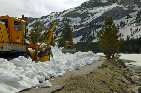
Snow removal crews work near a still-frozen Tenaya Lake
NPS Photo
avatar Tioga Road Plowing June 2, 2017 Update
June 02, 2017 04:42PM
Road crews are plowing from west to east and are near Lamb Dome, which is about halfway between Tenaya Lake and Tuolumne Meadows.
Re: Tioga Road Plowing June 2, 2017 Update
June 03, 2017 07:14PM
Quote
eeek
Road crews are plowing from west to east and are near Lamb Dome, which is about halfway between Tenaya Lake and Tuolumne Meadows.

Wohoo!! Thanks for the info, appreciate it. Keeping my fingers crossed to grab a last minute wilderness permit and campground permit later on smiling smiley
avatar Re: Tioga Road Plowing June 2, 2017 Update
June 05, 2017 09:24AM
The NPS Yosemite site now says "The Tioga Road is closed from South Fork Bridge (6.5 miles east of Tuolumne Grove/NatureBridge in the Crane Flat area) to Tioga Pass."

Doe this mean the Tioga road is partially open past Tamarack Flat?

How about Yosemite Creek?
avatar Re: Tioga Road Plowing June 2, 2017 Update
June 05, 2017 10:19AM
Quote
Coolburn
The NPS Yosemite site now says "The Tioga Road is closed from South Fork Bridge (6.5 miles east of Tuolumne Grove/NatureBridge in the Crane Flat area) to Tioga Pass."

Doe this mean the Tioga road is partially open past Tamarack Flat?

How about Yosemite Creek?

Cool. They are using the gates further towards Tioga Pass.

It certainly means the road is open to South Fork Tuolumne River...
here:
https://mappingsupport.com/p/gmap4.php?ll=37.792371,-119.722910&z=15&t=t4

Not open to Yosemite Creek.

Guess I wasted my time here:
http://yosemitenews.info/forum/read.php?17,89263,89325#msg-89325

You could start your trek here:
https://mappingsupport.com/p/gmap4.php?ll=37.784028,-119.741750&z=15&t=t4

There are bear boxes at this TH. (there are none at Tamarack Flat Campground) (for backpack use)

Have fun


Chick-on is looking at you!
avatar Re: Tioga Road Plowing June 2, 2017 Update
June 05, 2017 10:24AM
And yes, there are creeklets to cross if you take the trail...

Maybe just park at Gin Flat or Tam Creek Campground road junction.
On the OTHER side of the street there is a sign.
iirc it says no overnight camping


Chick-on is looking at you!
avatar Re: Tioga Road Plowing June 2, 2017 Update
June 05, 2017 10:57AM
Chick-on

Nothing you write is a waste of time. I read and appreciate it all! Thanks for the tips and expertise. I'm trying to make sure I have all contingencies covered. Ideally my north rim trek would leave from Tamarack Flat campground, exit Porcupine Flat, and catch the Tuolumne Hiker's bus back to the Tamarack campground, but the road has to be open, the bus has to be running, and it's probably too much to ask for the campground to be open. So I've made plans for everything I can think of, and now I'm narrowing down the options. So it looks like I'm clear to leave from Tamarack, but getting back will be the challenge!
avatar Re: Tioga Road Plowing June 2, 2017 Update
June 05, 2017 11:04AM
Chick-on,

If you were hiking at night, would you take the road or the trail to Tamarack flat campground?
avatar Re: Tioga Road Plowing June 2, 2017 Update
June 05, 2017 11:18AM
Quote
Coolburn
Chick-on,

If you were hiking at night, would you take the road or the trail to Tamarack flat campground?

Why are you hiking at night?

With the winter we had... I'd take the Tam Flat Camground road ...

The trail from Tioga may have washouts... and may be very interesting...

I'd expect Tioga to be open to Yosemite Creek by end of June... though the area near White Wolf holds snow...

Anyzoo... got multiple cars?


Chick-on is looking at you!
avatar Re: Tioga Road Plowing June 2, 2017 Update
June 05, 2017 12:30PM
Rafting the Tuolumne during the day, starting the hike that evening. We will have multiple cars.
avatar Re: Tioga Road Plowing June 2, 2017 Update
June 05, 2017 01:13PM
I asked on account of the wilderness office closing at 4-4:30 ish and all...
And if you got your permit that day... it would be hard to start in the dark
unless you shuttling cars and all...

So I guess someone else in your party is getting your permit or you are
getting it the prior day. Ok

With multiple cars I was going to say to try to put one down in the valley
if needed for a way out and back to your car.

You'll probably want to get to Cascade Creek to camp...
either side of the bridge has places...

You're not allowed to camp in the campground...

Sorry if telling you stuff you already know.

If you put a car at Yosemite Creek for exit... be aware that Old Tioga
is not something you want to hike on... Yosemite Creek may be
very problematic to cross (along with Bluejay and a no named creek
further upstream) ... yadda yadda yadda

So... cross country skillz or some variation and such are a plus

Ask more if u like

Have fun rafting Tuolumne... I'd think you'd be SPENT doing that
and then hiking 4 miles+ the same day... MAY be a "what were we
thinking?" moment...
YMMV as they say

Have fun


Chick-on is looking at you!
Sorry, only registered users may post in this forum.

Click here to login